| YORK MUNI YORK NE |
| |
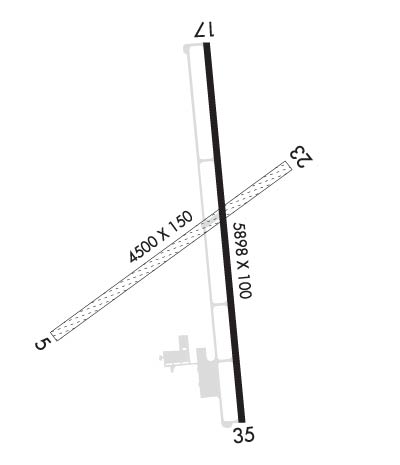
| Lat: N 4053.8 Long: W 09737.4 Elev: 1670 Var: -06 Longest Runway: 5898 | ||
| AWOS: 124.17 CTAF: 122.8 | ||
| ||||||||||||||||||||||||||||||||||||||||||||||||||||||||||||||||||||
| ||||||||||||||||||||||||||||||||||||||||||||||||||||||||||||||||||||
| ||||||||||||||||||||||||||||||||||||||||||||||||||||||||||||||||||||
| Rwy | Rwy | |||||||
| 4500x150 | 4500' | 4500x150 | 4500' | |||||
| 5898x100 | 5898' | 5898x100 | 5498' | |||||
| Runway ID | Single Wheel | Double Wheel | Double Tandem Wheel | Dual Double Wheel |
| 05/23 | N/A | N/A | N/A | N/A |
| 17/35 | 30,000 | 38,000 | N/A | N/A |
| These numbers are Advisory and are not limits. The Airport Manager should have more accurate Weight Limits | ||||
 Airport Diagram might not be current. | |
| Facility Name: | YORK MUNI |
| City Name: | YORK |
| County: | YORK |
| State abbrev: | NE |
| State Name: | NEBRASKA |
| Ownership: | PUBLICLY OWNED |
| Use: | OPEN TO THE PUBLIC |
| Owner's Name: | CITY OF YORK |
| Address: | PO BOX 276 |
| YORK, NE 68467-0276 | |
| Owner's Phone: | 402-363-2600 |
| Manager's Name: | RANDY HALL; RANDY HALL AIRPORT OPS MANAGER |
| Address: | 1112 HWY 34 |
| YORK, NE 68467-3512 | |
| Phone: | 402-366-5876 |
| FAA Region: | CENTRAL |
| FAA Field Office: | NONE |
| Date | Sunrise | Sunset |
|---|---|---|
| 09/24/21 Friday | 7:20 | 19:25 |
| 09/25/21 Saturday | 7:21 | 19:23 |
| 09/26/21 Sunday | 7:22 | 19:21 |
| 09/27/21 Monday | 7:23 | 19:20 |
| 09/28/21 Tuesday | 7:24 | 19:18 |
| 09/29/21 Wednesday | 7:25 | 19:16 |
| 09/30/21 Thursday | 7:26 | 19:14 |
| 10/01/21 Friday | 7:27 | 19:13 |
| 10/02/21 Saturday | 7:28 | 19:11 |
| 10/03/21 Sunday | 7:29 | 19:09 |
| 10/04/21 Monday | 7:30 | 19:08 |
| 10/05/21 Tuesday | 7:31 | 19:06 |
| 10/06/21 Wednesday | 7:32 | 19:05 |
| 10/07/21 Thursday | 7:33 | 19:03 |
| Airport Attendance Schedule | 7 Days A Week 0700-1700; FOR SVC AFTER HRS CALL (402) 366-5876 |
| Airport Status | OPERATIONAL (This Status can change at any time - please check NOTAMS) |
| Airport Lighting Schedule | ACTVT MIRL RY 17/35; PAPI RYS 17 & 35; REIL RYS 17 & 35 - CTAF. |
| Airport Storage Available | Tie Downs, Hanger |
| Extra Services Available | Crop Dusting |
| Wind Indicator | YES - (lighted) |
| Control Tower | NO |
| CTAF Frequency | 122.800 |
| Unicom Frequency | 122.800 |
| Rotating Beacon Color | CLEAR-GREEN (Light Land Airport) |
| Segmented Circle | YES |
| Landing Fee |
| Airport Inspected | STATE - performed by STATE AERONAUTICAL PERSONNEL |
| Inspection Date | 05/20/2020 |
| Type of Fuel Available | Grade 100LL, JET A (freeze point -40C) |
| Airframe Repair Service | MINOR |
| Power Plant Repair Service | MINOR |
| Latitude | N4053.8 |
| Longitude | W09737.4 (ESTIMATED) |
| Arpt Elevation | 1669ft (SURVEYED) |
| Magnetic Variation | 06E |
| 1 miles NW | of YORK |
| Traffic Pattern Altitude | |
| Sectional Chart | OMAHA |
| Operations (Reported) | Yearly | Avg. Daily |
|---|---|---|
| General Aviation Transient | 3950 | 11 |
| General Aviation Local | 6200 | 17 |
| Air Taxi | 300 | 1 |
| Commerical | 0 | 0 |
| Commuter | 0 | 0 |
| Military | 25 | 0 |
| Aircraft based on Field | |
|---|---|
| General Aviation Singles | 18 |
| General Aviation Multi | 0 |
| Jet Aircraft | 0 |
| General Aviation Helicopters | 0 |
| Military Aircraft | 0 |
| Gliders | 2 |
| Ultralights | 0 |
| FSS on field | NO |
| FSS tie-in | COLUMBUS |
| FSS Phone | 1-800-WX-BRIEF |
| Who issues Notams | JYR |
| Notam D service at airport | YES |
| ARTCC Name | MINNEAPOLIS |
| Airport Certification | |
| Aircraft Rescue & Firefighting Index | None |
| Airport of Entry | No |
| Custom Landing Rights | No |
| Joint Civil/Military | No |
| Military Landing rights | No |
| NATIONAL PLAN OF INTEGRATED AIRPORT SYSTEMS (NPIAS) |
| GRANT AGREEMENTS UNDER FAAP/ADAP/AIP |
| ASSURANCES PURSUANT TO TITLE VI, CIVIL RIGHTS ACT OF 1964 |
| RY 35 DESIGNATED AS CALM WIND RY. |
| FOR CD CTC MINNEAPOLIS ARTCC AT 651-463-5588. |
| RWY 05/2 3 NOT PLOWED WINTER MONTHS. |
Airport Communications & Frequencies:
| |||||||||
| Runway: 05 | Runway: 23 | ||
| Mag heading: | 48° | Mag heading: | 228° |
| Rwy Slope: | -.02% Down | Rwy Slope: | .02% Up |
| Approach: | Approach: | ||
| Pattern: | Left Traffic | Pattern: | Left Traffic |
| Markings: | Markings: | ||
| Marking Condition: | Marking Condition: | ||
| Arresting Dev: | Arresting Dev: | ||
| Lat & Long: | N4053.5 W09737.9 | Lat. & Long.: | N4054.0 W09737.2 |
| Elev: | 1665.0 ft. MSL | Elev: | 1664.0 ft. MSL |
| TCH: | TCH: | ||
| Visual Glide Path: | Visual Glide Path: | ||
| Displaced Threshold: | No | Displaced Threshold: | No |
| Touchdown Zone: | YES | Touchdown Zone: | YES |
| Touchdown Elev.: | 1665.0 feet | Touchdown Elev.: | 1664.0 feet |
| Visual Glide Slope: | Visual Glide Slope: | ||
| RVR Equipment: | RVR Equipment: | ||
| RVV Equipment: | NO | RVV Equipment: | NO |
| Approach Lights: | Approach Lights: | ||
| REIL: | NO | REIL: | NO |
| Centerline Lights: | NO | Centerline Lights: | NO |
| Touchdown lights: | NO | Touchdown lights: | NO |
| Runway Category: | Runway with a Visual Approach | Runway Category: | Runway with a Visual Approach |
| Declared Distances: | Declared Distances: | ||
| Obstructions: | POLE; RWY 05 CNTR PIVOT ROTATES INTO APCH DURING IRRIGATION SEASON. | Obstructions: | PLINE |
| Marked: | NOT Marked/Lighted | Marked: | NOT Marked/Lighted |
| Clearance slope: | 21:1 | Clearance slope: | 20:1 |
| Obstruction height: | 46 feet AGL | Obstruction height: | 40 feet AGL |
| Dist. from runway: | 1004 feet | Dist. from runway: | 829 feet |
| Centerline offset: | 219 left of centerline | Centerline offset: | 113 feet right of centerline |
| Comments: | Comments: |
| Runway: 17 | Runway: 35 | ||
| Mag heading: | 169° | Mag heading: | 349° |
| Rwy Slope: | .08% Up | Rwy Slope: | -.08% Down |
| Approach: | Approach: | ||
| Pattern: | Left Traffic | Pattern: | Left Traffic |
| Markings: | NONPRECISION INSTRUMENT | Markings: | NONPRECISION INSTRUMENT |
| Marking Condition: | GOOD | Marking Condition: | GOOD |
| Arresting Dev: | Arresting Dev: | ||
| Lat & Long: | N4054.3 W09737.4 | Lat. & Long.: | N4053.3 W09737.3 |
| Elev: | 1664.9 ft. MSL | Elev: | 1669.7 ft. MSL |
| TCH: | 40 ft. AGL | TCH: | 40 ft. AGL |
| Visual Glide Path: | 3.00 degrees | Visual Glide Path: | 3.00 degrees |
| Displaced Threshold: | No | Displaced Threshold: | 400 feet |
| Touchdown Zone: | YES | Touchdown Zone: | YES |
| Touchdown Elev.: | 1665.0 feet | Touchdown Elev.: | 1669.7 feet |
| Visual Glide Slope: | 2-Light PAPI on LEFT side of Runway | Visual Glide Slope: | 2-Light PAPI on LEFT side of Runway |
| RVR Equipment: | RVR Equipment: | ||
| RVV Equipment: | NO | RVV Equipment: | NO |
| Approach Lights: | Approach Lights: | ||
| REIL: | YES | REIL: | YES |
| Centerline Lights: | NO | Centerline Lights: | NO |
| Touchdown lights: | NO | Touchdown lights: | NO |
| Runway Category: | D | Runway Category: | D |
| Declared Distances: | TORA:5900' TODA:5900' ASDA:5500' LDA:5900' | Declared Distances: | TORA:5900' TODA:5900' ASDA:5900' LDA:5500' |
| Obstructions: | POLE | Obstructions: | ROAD |
| Marked: | NOT Marked/Lighted | Marked: | NOT Marked/Lighted |
| Clearance slope: | 27:1; RWY 35 APCH SLOPE 50:1 DUE TO 12 FT ROAD 1020 FT FROM DSPLCD THLD. | Clearance slope: | 35:1 |
| Obstruction height: | 46 feet AGL | Obstruction height: | 12 feet AGL |
| Dist. from runway: | 1437 feet | Dist. from runway: | 620 feet |
| Centerline offset: | 172 left of centerline | Centerline offset: | |
| Comments: | Comments: |
Thanks for using FltPlan.com
all rights reserved © 1999-2021 by Flight Plan LLC