
| LEESBURG EXECUTIVE LEESBURG VA |
| |
| Lat: N 3904.7 Long: W 07733.5 Elev: 390 Var: +10 Longest Runway: 5500 | ||
| Clr Del: 118.55 AWOS: 125.22 Ground: 120.5 Tower: 127.5 | ||

| |||||||||||||||||||||||||||||||||||||||||||||||||||||||||||||||||||||
| |||||||||||||||||||||||||||||||||||||||||||||||||||||||||||||||||||||
| |||||||||||||||||||||||||||||||||||||||||||||||||||||||||||||||||||||
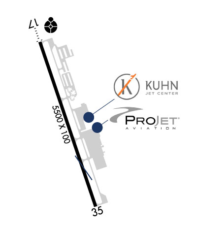
| FBOs at nearby airports who want your business: | |||||||||||||||||
| |||||||||||||||||
| Rwy | Rwy | |||||||
| 5500x100 | 5500' | 111.75 - 171° | 5500x100 | 5500' | ||||
| Runway ID | Single Wheel | Double Wheel | Double Tandem Wheel | Dual Double Wheel |
| 17/35 | 30,000 | 70,000 | N/A | N/A |
| These numbers are Advisory and are not limits. The Airport Manager should have more accurate Weight Limits | ||||
 Airport Diagram might not be current. | |
| Facility Name: | LEESBURG EXEC |
| City Name: | LEESBURG |
| County: | LOUDOUN |
| State abbrev: | VA |
| State Name: | VIRGINIA |
| Ownership: | PUBLICLY OWNED |
| Use: | OPEN TO THE PUBLIC |
| Owner's Name: | TOWN OF LEESBURG |
| Address: | 25 WEST MARKET ST., 25 WEST MARKET ST. |
| LEESBURG, VA 20176 | |
| Owner's Phone: | 703-777-2420 |
| Manager's Name: | SCOTT COFFMAN |
| Address: | 1001 SYCOLIN ROAD, SE, SUITE 7 |
| LEESBURG, VA 20175 | |
| Phone: | 703-737-7125 |
| FAA Region: | EASTERN |
| FAA Field Office: | DCA |
| Date | Sunrise | Sunset |
|---|---|---|
| 09/24/21 Friday | 6:59 | 19:04 |
| 09/25/21 Saturday | 7:00 | 19:03 |
| 09/26/21 Sunday | 7:01 | 19:01 |
| 09/27/21 Monday | 7:02 | 19:00 |
| 09/28/21 Tuesday | 7:03 | 18:58 |
| 09/29/21 Wednesday | 7:04 | 18:56 |
| 09/30/21 Thursday | 7:05 | 18:55 |
| 10/01/21 Friday | 7:06 | 18:53 |
| 10/02/21 Saturday | 7:07 | 18:52 |
| 10/03/21 Sunday | 7:08 | 18:50 |
| 10/04/21 Monday | 7:09 | 18:49 |
| 10/05/21 Tuesday | 7:10 | 18:47 |
| 10/06/21 Wednesday | 7:11 | 18:45 |
| 10/07/21 Thursday | 7:12 | 18:44 |
| Airport Attendance Schedule | 7 Days A Week 0500-2000; FOR SVC AFT HRS CALL 703-889-8558. |
| Airport Status | OPERATIONAL (This Status can change at any time - please check NOTAMS) |
| Airport Lighting Schedule | WHEN ATCT CLSD ACTVT ODALS RWY 17; REIL RWY 17 & 35; PAPI RWY 17 & 35; HIRL RWY 17/35 - CTAF. |
| Airport Storage Available | Tie Downs, Hanger |
| Extra Services Available | Air Ambulance, Charter, Flight Instruction, Aircraft Rental, Aircraft Sales |
| Wind Indicator | YES - (unlit) |
| Control Tower | YES |
| CTAF Frequency | 127.500 |
| Unicom Frequency | 122.975 |
| Rotating Beacon Color | CLEAR-GREEN (Light Land Airport) |
| Segmented Circle | YES |
| Landing Fee | NO |
| Airport Inspected | STATE - performed by STATE AERONAUTICAL PERSONNEL |
| Inspection Date | 09/24/2018 |
| Type of Fuel Available | Grade 100LL, JET A (freeze point -40C) |
| Airframe Repair Service | MAJOR |
| Power Plant Repair Service | MAJOR |
| Latitude | N3904.7 |
| Longitude | W07733.5 (ESTIMATED) |
| Arpt Elevation | 389ft (SURVEYED) |
| Magnetic Variation | 10W |
| 3 miles S | of LEESBURG |
| Traffic Pattern Altitude | 810 |
| Sectional Chart | WASHINGTON |
| Operations (Reported) | Yearly | Avg. Daily |
|---|---|---|
| General Aviation Transient | 12160 | 33 |
| General Aviation Local | 90735 | 249 |
| Air Taxi | 2539 | 7 |
| Commerical | 0 | 0 |
| Commuter | 0 | 0 |
| Military | 1245 | 3 |
| Aircraft based on Field | |
|---|---|
| General Aviation Singles | 167 |
| General Aviation Multi | 22 |
| Jet Aircraft | 11 |
| General Aviation Helicopters | 6 |
| Military Aircraft | 0 |
| Gliders | 1 |
| Ultralights | 0 |
| FSS on field | NO |
| FSS tie-in | LEESBURG |
| FSS Phone | 1-800-WX-BRIEF |
| Who issues Notams | JYO |
| Notam D service at airport | YES |
| ARTCC Name | WASHINGTON |
| Airport Certification | |
| Aircraft Rescue & Firefighting Index | None |
| Airport of Entry | No |
| Custom Landing Rights | YES |
| Joint Civil/Military | No |
| Military Landing rights | YES |
| NATIONAL PLAN OF INTEGRATED AIRPORT SYSTEMS (NPIAS) |
| GRANT AGREEMENTS UNDER FAAP/ADAP/AIP |
| ASSURANCES PURSUANT TO TITLE VI, CIVIL RIGHTS ACT OF 1964 |
| FOR FUEL & OTR SVCS CTC ARPT OPNS ON FREQ 128.95. |
| RAMP FENCE S/W SIDE RAMPS LEAD IN LINES ON WEST RAMP NA. |
| PAEW ON & INVOF ARPT. |
| PSBL THERMAL PLUMES FM PWR PLANT 1.3 NM SSE. |
| FOR CD WHEN ATCT CLSD, CTC POTOMAC APCH 118.55 OR 866-709-4993. |
| DURG ATCT HRS OF OPN, SGL LGT GUN LCTD AT TRML. |
| BIRDS & DEER ON & INVOF ARPT. |
| HEL ACT ON & INVOF ARPT. |
| CALM WIND USE RWY 17. |
Airport Communications & Frequencies:
| |||||||||||||||||||||||||
| Runway: 17 | Runway: 35 | ||
| Mag heading: | 171° | Mag heading: | 351° |
| Rwy Slope: | .17% Up | Rwy Slope: | -.17% Down |
| Approach: | ILS/DME | Approach: | |
| Pattern: | Left Traffic | Pattern: | Left Traffic |
| Markings: | PRECISION INSTRUMENT | Markings: | NONPRECISION INSTRUMENT |
| Marking Condition: | GOOD | Marking Condition: | GOOD |
| Arresting Dev: | Arresting Dev: | ||
| Lat & Long: | N3905.1 W07733.6 | Lat. & Long.: | N3904.2 W07733.3 |
| Elev: | 377.6 ft. MSL | Elev: | 387.2 ft. MSL |
| TCH: | 45 ft. AGL | TCH: | 37 ft. AGL |
| Visual Glide Path: | 3.00 degrees | Visual Glide Path: | 3.00 degrees |
| Displaced Threshold: | No | Displaced Threshold: | No |
| Touchdown Zone: | YES | Touchdown Zone: | YES |
| Touchdown Elev.: | 383.1 feet | Touchdown Elev.: | 389.5 feet |
| Visual Glide Slope: | 4-Light PAPI on LEFT side of Runway | Visual Glide Slope: | 4-Light PAPI on LEFT side of Runway |
| RVR Equipment: | RVR Equipment: | ||
| RVV Equipment: | NO | RVV Equipment: | NO |
| Approach Lights: | ODALS - omnidirectional approach lighting system; NSTD ODALS, 3 LGT CONFIGURATION. | Approach Lights: | |
| REIL: | YES | REIL: | YES |
| Centerline Lights: | NO | Centerline Lights: | NO |
| Touchdown lights: | NO | Touchdown lights: | NO |
| Runway Category: | Precision Instrument Runway | Runway Category: | Runway with a Visual Approach |
| Declared Distances: | Declared Distances: | ||
| Obstructions: | TREE | Obstructions: | TREE |
| Marked: | NOT Marked/Lighted | Marked: | NOT Marked/Lighted |
| Clearance slope: | 36:1 | Clearance slope: | 23:1 |
| Obstruction height: | 24 feet AGL | Obstruction height: | 77 feet AGL |
| Dist. from runway: | 1072 feet | Dist. from runway: | 2041 feet |
| Centerline offset: | 526 left of centerline | Centerline offset: | 362 feet right of centerline |
| Comments: | Comments: |
Thanks for using FltPlan.com
all rights reserved © 1999-2021 by Flight Plan LLC