
| ST JAMES MUNI ST JAMES MN |
| |
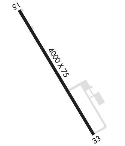
| Lat: N 4359.2 Long: W 09433.5 Elev: 1068 Var: -01 Longest Runway: 3999 | ||
| AWOS: 260K CTAF: 122.9 | ||
| ||||||||||||||||||||||||||||||||||||||||||||
| ||||||||||||||||||||||||||||||||||||||||||||
| ||||||||||||||||||||||||||||||||||||||||||||
| Rwy | Rwy | |||||||
| 3999x75 | 3999' | 3999x75 | 3999' | |||||
| Runway ID | Single Wheel | Double Wheel | Double Tandem Wheel | Dual Double Wheel |
| 15/33 | N/A | N/A | N/A | N/A |
| These numbers are Advisory and are not limits. The Airport Manager should have more accurate Weight Limits | ||||
 Airport Diagram might not be current. | |
| Facility Name: | ST JAMES MUNI |
| City Name: | ST JAMES |
| County: | WATONWAN |
| State abbrev: | MN |
| State Name: | MINNESOTA |
| Ownership: | PUBLICLY OWNED |
| Use: | OPEN TO THE PUBLIC |
| Owner's Name: | CITY OF ST JAMES |
| Address: | 124 ARMSTRONG BLVD S, PO BOX 70 |
| SAINT JAMES, MN 56081 | |
| Owner's Phone: | 507-375-3241 |
| Manager's Name: | AMANDA GLASS |
| Address: | 124 ARMSTRONG BLVD S, PO BOX 70 |
| SAINT JAMES, MN 56081 | |
| Phone: | 507-375-3241 |
| FAA Region: | GREAT LAKES |
| FAA Field Office: | DMA |
| Date | Sunrise | Sunset |
|---|---|---|
| 09/24/21 Friday | 7:07 | 19:12 |
| 09/25/21 Saturday | 7:09 | 19:10 |
| 09/26/21 Sunday | 7:10 | 19:09 |
| 09/27/21 Monday | 7:11 | 19:07 |
| 09/28/21 Tuesday | 7:12 | 19:05 |
| 09/29/21 Wednesday | 7:13 | 19:03 |
| 09/30/21 Thursday | 7:14 | 19:01 |
| 10/01/21 Friday | 7:16 | 18:59 |
| 10/02/21 Saturday | 7:17 | 18:58 |
| 10/03/21 Sunday | 7:18 | 18:56 |
| 10/04/21 Monday | 7:19 | 18:54 |
| 10/05/21 Tuesday | 7:20 | 18:52 |
| 10/06/21 Wednesday | 7:22 | 18:50 |
| 10/07/21 Thursday | 7:23 | 18:49 |
| Airport Attendance Schedule | UNATTENDED; FOR SER CALL 507-375-3121. |
| Airport Status | OPERATIONAL (This Status can change at any time - please check NOTAMS) |
| Airport Lighting Schedule | ACTVT REIL RWY 15 & 33; PAPI RWY 15 & 33; MIRL RWY 15/33 - CTAF. |
| Airport Storage Available | Tie Downs |
| Extra Services Available | NONE |
| Wind Indicator | YES - (lighted) |
| Control Tower | NO |
| CTAF Frequency | 122.900 |
| Unicom Frequency | |
| Rotating Beacon Color | CLEAR-GREEN (Light Land Airport) |
| Segmented Circle | NO |
| Landing Fee |
| Airport Inspected | STATE - performed by STATE AERONAUTICAL PERSONNEL |
| Inspection Date | 08/07/2020 |
| Type of Fuel Available | Grade 100LL; -10FUEL AVBL H24 VIA CREDIT CARD. |
| Airframe Repair Service | NONE |
| Power Plant Repair Service | NONE |
| Latitude | N4359.2 |
| Longitude | W09433.5 (ESTIMATED) |
| Arpt Elevation | 1067ft (SURVEYED) |
| Magnetic Variation | 01E |
| 3 miles E | of ST JAMES |
| Traffic Pattern Altitude | |
| Sectional Chart | OMAHA |
| Operations (Reported) | Yearly | Avg. Daily |
|---|---|---|
| General Aviation Transient | 2285 | 6 |
| General Aviation Local | 3200 | 9 |
| Air Taxi | 0 | 0 |
| Commerical | 0 | 0 |
| Commuter | 0 | 0 |
| Military | 0 | 0 |
| Aircraft based on Field | |
|---|---|
| General Aviation Singles | 11 |
| General Aviation Multi | 0 |
| Jet Aircraft | 1 |
| General Aviation Helicopters | 0 |
| Military Aircraft | 0 |
| Gliders | 0 |
| Ultralights | 0 |
| FSS on field | NO |
| FSS tie-in | PRINCETON |
| FSS Phone | 1-800-WX-BRIEF |
| Who issues Notams | JYG |
| Notam D service at airport | YES |
| ARTCC Name | MINNEAPOLIS |
| Airport Certification | |
| Aircraft Rescue & Firefighting Index | None |
| Airport of Entry | No |
| Custom Landing Rights | No |
| Joint Civil/Military | No |
| Military Landing rights | YES |
| NATIONAL PLAN OF INTEGRATED AIRPORT SYSTEMS (NPIAS) |
| ASSURANCES PURSUANT TO TITLE VI, CIVIL RIGHTS ACT OF 1964 |
| GRANT AGREEMENT HAS EXPIRED; HOWEVER, AGREEMENT REMAINS IN EFFECT FOR THIS FACILITY AS LONG AS IT IS PUBLIC USE. |
| ULTRALIGHT ACT ON & INVOF ARPT. |
| GCO AVBL ON FREQ 121.725 THRU MINNEAPOLIS ARTCC & FLT SVCS. |
| RWY 33 RT OF CTR LINE FRM APP END -120 TO -183 FT CATTAILS IN PRIMARY SURFACE |
| ARR/DEP BLDG ACES CODE FM RAMP: 1215#; ACES CODE FM PRKG LOT: 1215. |
| FOR CD IF UNA VIA GCO CTC MINNEAPOLIS ARTCC AT 651-463-5588. |
Airport Communications & Frequencies:
| |||||||
| Runway: 15 | Runway: 33 | ||
| Mag heading: | 148° | Mag heading: | 328° |
| Rwy Slope: | .10% Up | Rwy Slope: | -.10% Down |
| Approach: | Approach: | ||
| Pattern: | Left Traffic | Pattern: | Left Traffic |
| Markings: | NONPRECISION INSTRUMENT | Markings: | NONPRECISION INSTRUMENT |
| Marking Condition: | GOOD | Marking Condition: | GOOD |
| Arresting Dev: | Arresting Dev: | ||
| Lat & Long: | N4359.5 W09433.7 | Lat. & Long.: | N4358.9 W09433.2 |
| Elev: | 1061.3 ft. MSL | Elev: | 1065.3 ft. MSL |
| TCH: | 40 ft. AGL | TCH: | 40 ft. AGL |
| Visual Glide Path: | 2.83 degrees | Visual Glide Path: | 2.83 degrees |
| Displaced Threshold: | No | Displaced Threshold: | No |
| Touchdown Zone: | YES | Touchdown Zone: | YES |
| Touchdown Elev.: | 1067.3 feet | Touchdown Elev.: | 1067.7 feet |
| Visual Glide Slope: | 4-Light PAPI on LEFT side of Runway | Visual Glide Slope: | 4-Light PAPI on LEFT side of Runway |
| RVR Equipment: | RVR Equipment: | ||
| RVV Equipment: | NO | RVV Equipment: | NO |
| Approach Lights: | Approach Lights: | ||
| REIL: | YES | REIL: | YES |
| Centerline Lights: | NO | Centerline Lights: | NO |
| Touchdown lights: | NO | Touchdown lights: | NO |
| Runway Category: | Runway with a Non-precision Approach | Runway Category: | Runway with a Non-precision Approach |
| Declared Distances: | Declared Distances: |
Thanks for using FltPlan.com
all rights reserved © 1999-2021 by Flight Plan LLC
