| JACKSON COUNTY-REYNOLDS FIELD JACKSON MI |
| |
| Lat: N 4215.6 Long: W 08427.7 Elev: 1001 Var: +07 Longest Runway: 5351 | ||
| Clr Del: 121.9 Dept. ATIS: 125.72 Arr. ATIS: 125.72 AWOS: 125.72 Ground: 121.9 Tower: 128.47 | ||
| ||||||||||||||||||||||||||||||||||||||||||||||||||||||||||||||||||||
| ||||||||||||||||||||||||||||||||||||||||||||||||||||||||||||||||||||
| ||||||||||||||||||||||||||||||||||||||||||||||||||||||||||||||||||||
| Rwy | Rwy | |||||||
| 5351x100 | 5351' | 5351x100 | 5351' | 109.10 - 254° | ||||
| 4000x100 | 4000' | 4000x100 | 4000' | |||||
| Runway ID | Single Wheel | Double Wheel | Double Tandem Wheel | Dual Double Wheel |
| 07/25 | 76,000 | 100,000 | 180,000 | N/A |
| 14/32 | 42,000 | 62,000 | 115,000 | N/A |
| These numbers are Advisory and are not limits. The Airport Manager should have more accurate Weight Limits | ||||
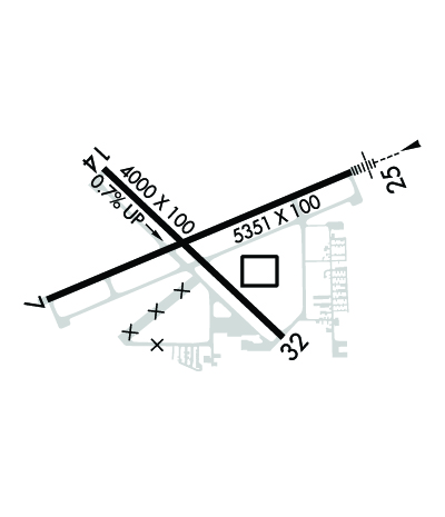 Airport Diagram might not be current. | |
| Facility Name: | JACKSON COUNTY/REYNOLDS FLD |
| City Name: | JACKSON |
| County: | JACKSON |
| State abbrev: | MI |
| State Name: | MICHIGAN |
| Ownership: | PUBLICLY OWNED |
| Use: | OPEN TO THE PUBLIC |
| Owner's Name: | JACKSON COUNTY |
| Address: | 120 W MICHIGAN AVE, JACKSON CO TOWER BLDG 5TH FL |
| JACKSON, MI 49201-1338 | |
| Owner's Phone: | 517-788-4335 |
| Manager's Name: | JUAN ZAPATA |
| Address: | 3606 WILDWOOD AVE |
| JACKSON, MI 49202-1864 | |
| Phone: | 517-788-4225 |
| FAA Region: | GREAT LAKES |
| FAA Field Office: | DET |
| Date | Sunrise | Sunset |
|---|---|---|
| 06/07/26 Sunday | 6:02 | 21:12 |
| 06/08/26 Monday | 6:01 | 21:12 |
| 06/09/26 Tuesday | 6:01 | 21:13 |
| 06/10/26 Wednesday | 6:01 | 21:14 |
| 06/11/26 Thursday | 6:01 | 21:14 |
| 06/12/26 Friday | 6:01 | 21:15 |
| 06/13/26 Saturday | 6:01 | 21:15 |
| 06/14/26 Sunday | 6:01 | 21:16 |
| 06/15/26 Monday | 6:01 | 21:16 |
| 06/16/26 Tuesday | 6:01 | 21:16 |
| 06/17/26 Wednesday | 6:01 | 21:17 |
| 06/18/26 Thursday | 6:01 | 21:17 |
| 06/19/26 Friday | 6:01 | 21:17 |
| 06/20/26 Saturday | 6:01 | 21:18 |
| Airport Attendance Schedule | MON-FRI 0800-1700, SAT-SUN 0800-1500 |
| Airport Status | OPERATIONAL (This Status can change at any time - please check NOTAMS) |
| Airport Lighting Schedule | WHEN ATCT CLSD ACTVT MALSR RWY 25; REIL RWY 07 & 32; PAPI RWY 07, 25, 14 & 32; HIRL RWY 07/25; MIRL RWY 14/32 - CTAF. |
| Airport Storage Available | Tie Downs, Hanger |
| Extra Services Available | Flight Instruction |
| Wind Indicator | YES - (lighted) |
| Control Tower | YES |
| CTAF Frequency | 128.475 |
| Unicom Frequency | 122.950 |
| Rotating Beacon Color | WG |
| Segmented Circle | YES |
| Landing Fee | NO |
| Airport Inspected | STATE - performed by STATE AERONAUTICAL PERSONNEL |
| Inspection Date | 06/12/2025 |
| Type of Fuel Available | Grade 100LL, JET A; -10100LL & JET A+ AVBL SELF SVC ON MAIN RAMP. |
| Airframe Repair Service | MAJOR |
| Power Plant Repair Service | MAJOR |
| Latitude | N4215.6 |
| Longitude | W08427.7 (ESTIMATED) |
| Arpt Elevation | 1000ft (SURVEYED) |
| Magnetic Variation | 07W |
| 2 miles W | of JACKSON |
| Traffic Pattern Altitude | |
| Sectional Chart | DETROIT |
| Operations (Reported) | Yearly | Avg. Daily |
|---|---|---|
| General Aviation Transient | 0 | 0 |
| General Aviation Local | 0 | 0 |
| Air Taxi | 0 | 0 |
| Commerical | 0 | 0 |
| Commuter | 0 | 0 |
| Military | 0 | 0 |
| Aircraft based on Field | |
|---|---|
| General Aviation Singles | 0 |
| General Aviation Multi | 0 |
| Jet Aircraft | 0 |
| General Aviation Helicopters | 0 |
| Military Aircraft | 0 |
| Gliders | 0 |
| Ultralights | 0 |
| FSS on field | NO |
| FSS tie-in | LANSING |
| FSS Phone | 1-800-WX-BRIEF |
| Who issues Notams | JXN |
| Notam D service at airport | YES |
| ARTCC Name | CLEVELAND |
| Airport Certification | |
| Aircraft Rescue & Firefighting Index | None |
| Airport of Entry | No |
| Custom Landing Rights | No |
| Joint Civil/Military | No |
| Military Landing rights | YES |
| NATIONAL PLAN OF INTEGRATED AIRPORT SYSTEMS (NPIAS) |
| GRANT AGREEMENTS UNDER FAAP/ADAP/AIP |
| ASSURANCES PURSUANT TO TITLE VI, CIVIL RIGHTS ACT OF 1964 |
| DEER & LRG BIRDS ON & INVOF ARPT. |
| LOW ALT HEL OPS PROHIBITED INVOF PRISON 4 MI NE. |
| WINTER FICONS UNMON WHEN ATCT CLSD. |
| ACFT TAXIING UP TWY D COULD POSSLY MISS THE TURN FOR TWY A & VIOLATE THE SAFETY ZONE FOR RWY 07/25. |
| FOR CD WHEN ATCT CLSD CTC GREAT LAKES APCH AT 269-459-3345, WHEN APCH CLSD CTC CLEVELAND ARTCC AT 440-774-0224/0490. |
Airport Communications & Frequencies:
| |||||||||||||||||||||||||||||||
| Runway: 07 | Runway: 25 | ||
| Mag heading: | 74° | Mag heading: | 254° |
| Rwy Slope: | .17% Up | Rwy Slope: | -.17% Down |
| Approach: | Approach: | ILS | |
| Pattern: | Left Traffic | Pattern: | Left Traffic |
| Markings: | PRECISION INSTRUMENT | Markings: | PRECISION INSTRUMENT |
| Marking Condition: | GOOD | Marking Condition: | GOOD |
| Arresting Dev: | Arresting Dev: | ||
| Lat & Long: | N4215.5 W08428.3 | Lat. & Long.: | N4215.8 W08427.2 |
| Elev: | 985.0 ft. MSL | Elev: | 993.9 ft. MSL |
| TCH: | 37 ft. AGL | TCH: | 45 ft. AGL |
| Visual Glide Path: | 3.00 degrees | Visual Glide Path: | 3.00 degrees |
| Displaced Threshold: | No | Displaced Threshold: | No |
| Touchdown Zone: | YES | Touchdown Zone: | YES |
| Touchdown Elev.: | 993.0 feet | Touchdown Elev.: | 995.5 feet |
| Visual Glide Slope: | 4-Light PAPI on LEFT side of Runway | Visual Glide Slope: | 4-Light PAPI on LEFT side of Runway |
| RVR Equipment: | RVR Equipment: | ||
| RVV Equipment: | NO | RVV Equipment: | NO |
| Approach Lights: | Approach Lights: | MALSR - 1,400 foot medium intensity approach lighting system with runway alignment indicator lights | |
| REIL: | YES | REIL: | NO |
| Centerline Lights: | NO | Centerline Lights: | NO |
| Touchdown lights: | NO | Touchdown lights: | NO |
| Runway Category: | Runway with a Non-precision Approach having visibility minimums greater than 3/4 mile | Runway Category: | Precision Instrument Runway |
| Declared Distances: | Declared Distances: | ||
| Obstructions: | PLINE | Obstructions: | TREES |
| Marked: | NOT Marked/Lighted | Marked: | NOT Marked/Lighted |
| Clearance slope: | 19:1 | Clearance slope: | 27:1 |
| Obstruction height: | 72 feet AGL | Obstruction height: | 94 feet AGL |
| Dist. from runway: | 1613 feet | Dist. from runway: | 2758 feet |
| Centerline offset: | 660 right of centerline | Centerline offset: | 773 feet left of centerline |
| Comments: | Comments: |
| Runway: 14 | Runway: 32 | ||
| Mag heading: | 140° | Mag heading: | 320° |
| Rwy Slope: | .71% Up | Rwy Slope: | -.71% Down |
| Approach: | Approach: | ||
| Pattern: | Left Traffic | Pattern: | Left Traffic |
| Markings: | NONPRECISION INSTRUMENT | Markings: | NONPRECISION INSTRUMENT |
| Marking Condition: | GOOD | Marking Condition: | GOOD |
| Arresting Dev: | Arresting Dev: | ||
| Lat & Long: | N4215.8 W08428.1 | Lat. & Long.: | N4215.4 W08427.4 |
| Elev: | 972.1 ft. MSL | Elev: | 1000.6 ft. MSL |
| TCH: | 25 ft. AGL | TCH: | 31 ft. AGL |
| Visual Glide Path: | 3.00 degrees | Visual Glide Path: | 3.50 degrees |
| Displaced Threshold: | No | Displaced Threshold: | No |
| Touchdown Zone: | YES | Touchdown Zone: | YES |
| Touchdown Elev.: | 995.7 feet | Touchdown Elev.: | 1000.8 feet |
| Visual Glide Slope: | 4-Light PAPI on LEFT side of Runway | Visual Glide Slope: | 4-Light PAPI on LEFT side of Runway |
| RVR Equipment: | RVR Equipment: | ||
| RVV Equipment: | NO | RVV Equipment: | NO |
| Approach Lights: | Approach Lights: | ||
| REIL: | NO | REIL: | YES |
| Centerline Lights: | NO | Centerline Lights: | NO |
| Touchdown lights: | NO | Touchdown lights: | NO |
| Runway Category: | Runway with a Non-precision Approach | Runway Category: | Runway with a Non-precision Approach |
| Declared Distances: | Declared Distances: | ||
| Obstructions: | TREE | Obstructions: | TREE |
| Marked: | NOT Marked/Lighted | Marked: | NOT Marked/Lighted |
| Clearance slope: | 11:1 | Clearance slope: | 19:1 |
| Obstruction height: | 20 feet AGL | Obstruction height: | 89 feet AGL |
| Dist. from runway: | 438 feet | Dist. from runway: | 1924 feet |
| Centerline offset: | 125 left of centerline | Centerline offset: | 100 feet right of centerline |
| Comments: | Comments: |
Thanks for using FltPlan.com
all rights reserved © 1999-2026 by Flight Plan LLC