| CLARK RGNL JEFFERSONVILLE IN |
| |
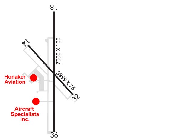
| Lat: N 3822.0 Long: W 08544.3 Elev: 478 Var: +02 Longest Runway: 7000 | ||
| Clr Del: 118.05 AWOS: 118.57 CTAF: 122.7 | ||
| |||||||||||||||||||||||||||||||||||||||||||||||||||||||||||||||||||||
| |||||||||||||||||||||||||||||||||||||||||||||||||||||||||||||||||||||
| |||||||||||||||||||||||||||||||||||||||||||||||||||||||||||||||||||||
| |||||||||||||||||||||||||||||||||||||||||||||||||||||||||||||||||||||
| Rwy | Rwy | |||||||
| 3899x75 | 3899' | 3899x75 | 3899' | |||||
| 7000x100 | 7000' | 111.70 - 181° | 7000x100 | 7000' | ||||
| Runway ID | Single Wheel | Double Wheel | Double Tandem Wheel | Dual Double Wheel |
| 14/32 | 12,000 | N/A | N/A | N/A |
| 18/36 | 45,000 | 60,000 | N/A | N/A |
| These numbers are Advisory and are not limits. The Airport Manager should have more accurate Weight Limits | ||||
 Airport Diagram might not be current. | |
| Facility Name: | CLARK RGNL |
| City Name: | JEFFERSONVILLE |
| County: | CLARK |
| State abbrev: | IN |
| State Name: | INDIANA |
| Ownership: | PUBLICLY OWNED |
| Use: | OPEN TO THE PUBLIC |
| Owner's Name: | SOUTH CENTRAL REGIONAL AIRPORT AUTH |
| Address: | 6003 PROPELLER LANE |
| SELLERSBURG, IN 47172 | |
| Owner's Phone: | 812-246-7460 |
| Manager's Name: | JOHN SECOR |
| Address: | 6003 PROPELLER LANE |
| SELLERSBURG, IN 47172 | |
| Phone: | 812-246-7460 |
| FAA Region: | GREAT LAKES |
| FAA Field Office: | CHI |
| Date | Sunrise | Sunset |
|---|---|---|
| 09/24/21 Friday | 7:32 | 19:37 |
| 09/25/21 Saturday | 7:33 | 19:36 |
| 09/26/21 Sunday | 7:34 | 19:34 |
| 09/27/21 Monday | 7:35 | 19:32 |
| 09/28/21 Tuesday | 7:36 | 19:31 |
| 09/29/21 Wednesday | 7:37 | 19:29 |
| 09/30/21 Thursday | 7:38 | 19:28 |
| 10/01/21 Friday | 7:38 | 19:26 |
| 10/02/21 Saturday | 7:39 | 19:25 |
| 10/03/21 Sunday | 7:40 | 19:23 |
| 10/04/21 Monday | 7:41 | 19:22 |
| 10/05/21 Tuesday | 7:42 | 19:20 |
| 10/06/21 Wednesday | 7:43 | 19:19 |
| 10/07/21 Thursday | 7:44 | 19:17 |
| Airport Attendance Schedule | 7 Days A Week 0600-2300 |
| Airport Status | OPERATIONAL (This Status can change at any time - please check NOTAMS) |
| Airport Lighting Schedule | ACTVT MALSR RWY 18; REIL RWY 18 & 36; PAPI RWY 18 & 36 - CTAF. MIRL RWY 18/36 OPR DUSK-DAWN. RWY 14/32 LGTS PPR - 812-987-2841. |
| Airport Storage Available | Tie Downs, Hanger |
| Extra Services Available | Air Freight, Cargo Handling, Charter, Flight Instruction, Aircraft Rental, Aircraft Sales |
| Wind Indicator | YES - (lighted) |
| Control Tower | NO |
| CTAF Frequency | 122.700 |
| Unicom Frequency | 122.700 |
| Rotating Beacon Color | CLEAR-GREEN (Light Land Airport) |
| Segmented Circle | YES |
| Landing Fee |
| Airport Inspected | STATE - performed by STATE AERONAUTICAL PERSONNEL |
| Inspection Date | 03/31/2020 |
| Type of Fuel Available | Grade 100LL, JET A (freeze point -40C) |
| Airframe Repair Service | MAJOR |
| Power Plant Repair Service | MAJOR |
| Latitude | N3822.0 |
| Longitude | W08544.3 (ESTIMATED) |
| Arpt Elevation | 477ft (SURVEYED) |
| Magnetic Variation | 02W |
| 5 miles N | of JEFFERSONVILLE |
| Traffic Pattern Altitude | 800 |
| Sectional Chart | ST LOUIS |
| Operations (Reported) | Yearly | Avg. Daily |
|---|---|---|
| General Aviation Transient | 21312 | 58 |
| General Aviation Local | 17793 | 49 |
| Air Taxi | 5325 | 15 |
| Commerical | 0 | 0 |
| Commuter | 0 | 0 |
| Military | 0 | 0 |
| Aircraft based on Field | |
|---|---|
| General Aviation Singles | 42 |
| General Aviation Multi | 68 |
| Jet Aircraft | 36 |
| General Aviation Helicopters | 7 |
| Military Aircraft | 0 |
| Gliders | 0 |
| Ultralights | 0 |
| FSS on field | NO |
| FSS tie-in | TERRE HAUTE |
| FSS Phone | 1-800-WX-BRIEF |
| Who issues Notams | HUF |
| Notam D service at airport | YES |
| ARTCC Name | INDIANAPOLIS |
| Airport Certification | |
| Aircraft Rescue & Firefighting Index | None |
| Airport of Entry | No |
| Custom Landing Rights | No |
| Joint Civil/Military | No |
| Military Landing rights | YES |
| NATIONAL PLAN OF INTEGRATED AIRPORT SYSTEMS (NPIAS) |
| GRANT AGREEMENTS UNDER FAAP/ADAP/AIP |
| ASSURANCES PURSUANT TO TITLE VI, CIVIL RIGHTS ACT OF 1964 |
| STUDENT ACT & WILDLIFE ON & INVOF ARPT. |
| LNDG FEE FOR NON BASE ACFT. |
| EMERG PHONE LCTD N SIDE OF AUTH BLDG - CTAF TO OPEN. |
| FOR CD CTC LOUISVILLE APCH AT 502-375-7499 |
Airport Communications & Frequencies:
| ||||||||||||||||
| Runway: 14 | Runway: 32 | ||
| Mag heading: | 140° | Mag heading: | 320° |
| Rwy Slope: | -.21% Down | Rwy Slope: | .21% Up |
| Approach: | Approach: | ||
| Pattern: | Left Traffic | Pattern: | Left Traffic |
| Markings: | BASIC | Markings: | BASIC |
| Marking Condition: | FAIR | Marking Condition: | FAIR |
| Arresting Dev: | Arresting Dev: | ||
| Lat & Long: | N3822.2 W08544.6 | Lat. & Long.: | N3821.8 W08544.0 |
| Elev: | 468.8 ft. MSL | Elev: | 460.8 ft. MSL |
| TCH: | 40 ft. AGL | TCH: | 43 ft. AGL |
| Visual Glide Path: | 3.00 degrees | Visual Glide Path: | 3.38 degrees |
| Displaced Threshold: | No | Displaced Threshold: | No |
| Touchdown Zone: | YES | Touchdown Zone: | YES |
| Touchdown Elev.: | 468.8 feet | Touchdown Elev.: | 461.7 feet |
| Visual Glide Slope: | 2-Light PAPI on LEFT side of Runway | Visual Glide Slope: | 2-Light PAPI on LEFT side of Runway |
| RVR Equipment: | RVR Equipment: | ||
| RVV Equipment: | NO | RVV Equipment: | NO |
| Approach Lights: | Approach Lights: | ||
| REIL: | YES | REIL: | YES |
| Centerline Lights: | NO | Centerline Lights: | NO |
| Touchdown lights: | NO | Touchdown lights: | NO |
| Runway Category: | Runway with a Visual Approach | Runway Category: | Runway with a Visual Approach |
| Declared Distances: | Declared Distances: |
| Runway: 18 | Runway: 36 | ||
| Mag heading: | 182° | Mag heading: | 2° |
| Rwy Slope: | -.23% Down | Rwy Slope: | .23% Up |
| Approach: | ILS | Approach: | |
| Pattern: | Left Traffic | Pattern: | Left Traffic |
| Markings: | PRECISION INSTRUMENT | Markings: | PRECISION INSTRUMENT |
| Marking Condition: | GOOD | Marking Condition: | GOOD |
| Arresting Dev: | Arresting Dev: | ||
| Lat & Long: | N3822.6 W08544.3 | Lat. & Long.: | N3821.4 W08544.3 |
| Elev: | 477.5 ft. MSL | Elev: | 461.2 ft. MSL |
| TCH: | 50 ft. AGL | TCH: | 40 ft. AGL |
| Visual Glide Path: | 3.00 degrees | Visual Glide Path: | 3.00 degrees |
| Displaced Threshold: | No | Displaced Threshold: | No |
| Touchdown Zone: | YES | Touchdown Zone: | YES |
| Touchdown Elev.: | 477.6 feet | Touchdown Elev.: | 461.6 feet |
| Visual Glide Slope: | 4-Light PAPI on LEFT side of Runway | Visual Glide Slope: | 4-Light PAPI on LEFT side of Runway |
| RVR Equipment: | RVR Equipment: | ||
| RVV Equipment: | NO | RVV Equipment: | NO |
| Approach Lights: | MALSR - 1,400 foot medium intensity approach lighting system with runway alignment indicator lights | Approach Lights: | |
| REIL: | YES | REIL: | YES |
| Centerline Lights: | NO | Centerline Lights: | NO |
| Touchdown lights: | NO | Touchdown lights: | NO |
| Runway Category: | Precision Instrument Runway | Runway Category: | Runway with a Visual Approach |
| Declared Distances: | Declared Distances: | ||
| Obstructions: | PLINE | Obstructions: | |
| Marked: | NOT Marked/Lighted | Marked: | |
| Clearance slope: | 42:1 | Clearance slope: | 20:1 |
| Obstruction height: | 70 feet AGL | Obstruction height: | |
| Dist. from runway: | 3150 feet | Dist. from runway: | |
| Centerline offset: | 894 left of centerline | Centerline offset: | |
| Comments: | Comments: |
Thanks for using FltPlan.com
all rights reserved © 1999-2021 by Flight Plan LLC