
| SOUTHERN WISCONSIN RGNL JANESVILLE WI |
| |
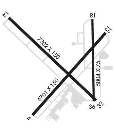
| Lat: N 4237.2 Long: W 08902.5 Elev: 808 Var: +02 Longest Runway: 7302 | ||
| Clr Del: 121.65 Dept. ATIS: 128.25 Arr. ATIS: 128.25 Ground: 121.65 Tower: 118.8 | ||
| ||||||||||||||||||||||||||||||||||||||||||||||||||||||||||||||||||||
| ||||||||||||||||||||||||||||||||||||||||||||||||||||||||||||||||||||
| ||||||||||||||||||||||||||||||||||||||||||||||||||||||||||||||||||||
| ||||||||||||||||||||||||||||||||||||||||||||||||||||||||||||||||||||
| Rwy | Rwy | |||||||
| 6701x150 | 6701' | 109.10 - 043° | 6701x150 | 6701' | ||||
| 7302x150 | 7302' | 7302x150 | 7302' | 111.35 - 315° | ||||
| 5004x75 | 5004' | 5004x75 | 5004' | |||||
| Runway ID | Single Wheel | Double Wheel | Double Tandem Wheel | Dual Double Wheel |
| 04/22 | 95,000 | 130,000 | N/A | N/A |
| 14/32 | 85,000 | 190,000 | N/A | N/A |
| 18/36 | 40,000 | 50,000 | N/A | N/A |
| These numbers are Advisory and are not limits. The Airport Manager should have more accurate Weight Limits | ||||
 Airport Diagram might not be current. | |
| Facility Name: | SOUTHERN WISCONSIN RGNL |
| City Name: | JANESVILLE |
| County: | ROCK |
| State abbrev: | WI |
| State Name: | WISCONSIN |
| Ownership: | PUBLICLY OWNED |
| Use: | OPEN TO THE PUBLIC |
| Owner's Name: | ROCK COUNTY |
| Address: | 51 SOUTH MAIN ST |
| JANESVILLE, WI 53545 | |
| Owner's Phone: | 608-757-5768 |
| Manager's Name: | GREG CULLEN; GREG CULLEN. |
| Address: | 1716 W. AIRPORT RD |
| JANESVILLE, WI 53546 | |
| Phone: | 608-757-5768 |
| FAA Region: | GREAT LAKES |
| FAA Field Office: | CHI |
| Date | Sunrise | Sunset |
|---|---|---|
| 09/24/21 Friday | 6:45 | 18:50 |
| 09/25/21 Saturday | 6:46 | 18:49 |
| 09/26/21 Sunday | 6:48 | 18:47 |
| 09/27/21 Monday | 6:49 | 18:45 |
| 09/28/21 Tuesday | 6:50 | 18:43 |
| 09/29/21 Wednesday | 6:51 | 18:41 |
| 09/30/21 Thursday | 6:52 | 18:40 |
| 10/01/21 Friday | 6:53 | 18:38 |
| 10/02/21 Saturday | 6:54 | 18:36 |
| 10/03/21 Sunday | 6:55 | 18:34 |
| 10/04/21 Monday | 6:56 | 18:33 |
| 10/05/21 Tuesday | 6:58 | 18:31 |
| 10/06/21 Wednesday | 6:59 | 18:29 |
| 10/07/21 Thursday | 7:00 | 18:28 |
| Airport Attendance Schedule | 7 Days A Week 0700-2245; CONDS NOT MONTRD MON-FRI 2245-0700, SAT, SUN OR FED HOLS. |
| Airport Status | OPERATIONAL (This Status can change at any time - please check NOTAMS) |
| Airport Lighting Schedule | ACTVT MALSR RWY 04 & 32; REIL RWY 14 & 22; VASI RWY 32; HIRL RWY 04/22 & 14/32; MIRL RWY 18/36 - CTAF. WHEN ATCT CLSD HIRL RWY 04/22 PRESET ON LOW INTST; INCR INTST - CTAF. PAPI RWY 04, 14, & 22 OPR CONSLY. |
| Airport Storage Available | Tie Downs, Hanger |
| Extra Services Available | Avionics, Charter, Flight Instruction, Aircraft Rental |
| Wind Indicator | YES - (lighted) |
| Control Tower | YES |
| CTAF Frequency | 118.800 |
| Unicom Frequency | 122.950 |
| Rotating Beacon Color | CLEAR-GREEN (Light Land Airport) |
| Segmented Circle | YES |
| Landing Fee | NO |
| Airport Inspected | FEDERAL - performed by FAA AIRPORTS FIELD PERSONNEL |
| Inspection Date | 11/30/2020 |
| Type of Fuel Available | Grade 100LL, JET A (freeze point -40C) |
| Airframe Repair Service | MAJOR |
| Power Plant Repair Service | MAJOR |
| Latitude | N4237.2 |
| Longitude | W08902.5 (ESTIMATED) |
| Arpt Elevation | 807ft (SURVEYED) |
| Magnetic Variation | 02W |
| 3 miles SW | of JANESVILLE |
| Traffic Pattern Altitude | |
| Sectional Chart | CHICAGO |
| Operations (Reported) | Yearly | Avg. Daily |
|---|---|---|
| General Aviation Transient | 23094 | 63 |
| General Aviation Local | 27174 | 74 |
| Air Taxi | 4925 | 13 |
| Commerical | 13 | 0 |
| Commuter | 0 | 0 |
| Military | 600 | 2 |
| Aircraft based on Field | |
|---|---|
| General Aviation Singles | 30 |
| General Aviation Multi | 1 |
| Jet Aircraft | 24 |
| General Aviation Helicopters | 3 |
| Military Aircraft | 0 |
| Gliders | 0 |
| Ultralights | 0 |
| FSS on field | NO |
| FSS tie-in | GREEN BAY |
| FSS Phone | 1-800-WX-BRIEF |
| Who issues Notams | JVL |
| Notam D service at airport | YES |
| ARTCC Name | CHICAGO |
| Airport Certification | CLSD TO SKEDD ACR OPS GTR THAN 9 PSGR SEATS. UNSKEDD ACR OPNS GTR THAN 30 PSGR SEATS; 90 DAY PPR - CALL AMGR. |
| Aircraft Rescue & Firefighting Index | AIRPORT HAS A CERTIFICATE UNDER CFR PART 139 |
| Airport of Entry | No |
| Custom Landing Rights | No |
| Joint Civil/Military | No |
| Military Landing rights | YES |
| NATIONAL PLAN OF INTEGRATED AIRPORT SYSTEMS (NPIAS) |
| GRANT AGREEMENTS UNDER FAAP/ADAP/AIP |
| ASSURANCES PURSUANT TO TITLE VI, CIVIL RIGHTS ACT OF 1964 |
| AGREEMENT UNDER DLAND OR DCLA HAS EXPIRED. |
| LGT SPORT ACFT WITH CRUISE SPEED OF 60 MPH OR LESS ENTER TFC PAT AT 500 AGL. |
| RWY 32 & 36 APCH ENDS CLOSELY ALIGNED; VERIFY CORRECT RWY AND COMPASS HEADING PRIOR TO DEP. |
| RWY 18/3 6 RWY 18/36 NOT AVBL FOR UNSKED ACR AT LEAST 31 PASGR SEATS. |
| RWY 04/2 2 APRONS & RAMPS RSTD TO 155 DTW GROSS WT. |
Airport Communications & Frequencies:
| ||||||||||||||||||||||||||||||
| Runway: 04 | Runway: 22 | ||
| Mag heading: | 44° | Mag heading: | 224° |
| Rwy Slope: | .02% Up | Rwy Slope: | -.02% Down |
| Approach: | ILS | Approach: | |
| Pattern: | Left Traffic | Pattern: | Left Traffic |
| Markings: | PRECISION INSTRUMENT | Markings: | PRECISION INSTRUMENT |
| Marking Condition: | GOOD | Marking Condition: | GOOD |
| Arresting Dev: | Arresting Dev: | ||
| Lat & Long: | N4236.7 W08903.0 | Lat. & Long.: | N4237.5 W08902.0 |
| Elev: | 803.6 ft. MSL | Elev: | 804.7 ft. MSL |
| TCH: | 54 ft. AGL | TCH: | 45 ft. AGL |
| Visual Glide Path: | 3.00 degrees | Visual Glide Path: | 3.00 degrees |
| Displaced Threshold: | No | Displaced Threshold: | No |
| Touchdown Zone: | YES | Touchdown Zone: | YES |
| Touchdown Elev.: | 805.6 feet | Touchdown Elev.: | 805.4 feet |
| Visual Glide Slope: | 4-Light PAPI on LEFT side of Runway | Visual Glide Slope: | 4-Light PAPI on LEFT side of Runway |
| RVR Equipment: | RVR Equipment: | ||
| RVV Equipment: | NO | RVV Equipment: | NO |
| Approach Lights: | MALSR - 1,400 foot medium intensity approach lighting system with runway alignment indicator lights | Approach Lights: | |
| REIL: | NO | REIL: | YES |
| Centerline Lights: | NO | Centerline Lights: | NO |
| Touchdown lights: | NO | Touchdown lights: | NO |
| Runway Category: | Precision Instrument Runway | Runway Category: | Runway with a Non-precision Approach having visibility minimums greater than 3/4 mile |
| Declared Distances: | TORA:6701' TODA:6701' ASDA:6701' LDA:6701' | Declared Distances: | TORA:6701' TODA:6701' ASDA:6701' LDA:6701' |
| Obstructions: | Obstructions: | TREE | |
| Marked: | Marked: | NOT Marked/Lighted | |
| Clearance slope: | 50:1 | Clearance slope: | 31:1 |
| Obstruction height: | Obstruction height: | 83 feet AGL | |
| Dist. from runway: | Dist. from runway: | 2792 feet | |
| Centerline offset: | Centerline offset: | 367 feet right of centerline | |
| Comments: | Comments: |
| Runway: 14 | Runway: 32 | ||
| Mag heading: | 136° | Mag heading: | 316° |
| Rwy Slope: | .14% Up | Rwy Slope: | -.14% Down |
| Approach: | Approach: | ILS/DME | |
| Pattern: | Left Traffic | Pattern: | Left Traffic |
| Markings: | PRECISION INSTRUMENT | Markings: | PRECISION INSTRUMENT |
| Marking Condition: | FAIR | Marking Condition: | GOOD |
| Arresting Dev: | Arresting Dev: | ||
| Lat & Long: | N4237.7 W08903.3 | Lat. & Long.: | N4236.9 W08902.1 |
| Elev: | 795.0 ft. MSL | Elev: | 805.3 ft. MSL |
| TCH: | 60 ft. AGL | TCH: | 51 ft. AGL |
| Visual Glide Path: | 3.00 degrees | Visual Glide Path: | 3.00 degrees |
| Displaced Threshold: | No | Displaced Threshold: | No |
| Touchdown Zone: | YES | Touchdown Zone: | YES |
| Touchdown Elev.: | 802.8 feet | Touchdown Elev.: | 806.1 feet |
| Visual Glide Slope: | 4-Light PAPI on LEFT side of Runway | Visual Glide Slope: | 4-BOX VASI ON LEFT SIDE OF RUNWAY |
| RVR Equipment: | RVR Equipment: | ||
| RVV Equipment: | NO | RVV Equipment: | NO |
| Approach Lights: | Approach Lights: | MALSR - 1,400 foot medium intensity approach lighting system with runway alignment indicator lights | |
| REIL: | YES | REIL: | NO |
| Centerline Lights: | NO | Centerline Lights: | NO |
| Touchdown lights: | NO | Touchdown lights: | NO |
| Runway Category: | D | Runway Category: | Precision Instrument Runway |
| Declared Distances: | TORA:7302' TODA:7302' ASDA:7302' LDA:7302' | Declared Distances: | TORA:7302' TODA:7302' ASDA:7302' LDA:7302' |
| Runway: 18 | Runway: 36 | ||
| Mag heading: | 181° | Mag heading: | 1° |
| Rwy Slope: | -.04% Down | Rwy Slope: | .04% Up |
| Approach: | Approach: | ||
| Pattern: | Left Traffic | Pattern: | Left Traffic |
| Markings: | BASIC | Markings: | BASIC |
| Marking Condition: | FAIR | Marking Condition: | FAIR |
| Arresting Dev: | Arresting Dev: | ||
| Lat & Long: | N4237.7 W08902.2 | Lat. & Long.: | N4236.8 W08902.2 |
| Elev: | 807.7 ft. MSL | Elev: | 805.7 ft. MSL |
| TCH: | TCH: | ||
| Visual Glide Path: | Visual Glide Path: | ||
| Displaced Threshold: | No | Displaced Threshold: | No |
| Touchdown Zone: | YES | Touchdown Zone: | YES |
| Touchdown Elev.: | 807.7 feet | Touchdown Elev.: | 806.3 feet |
| Visual Glide Slope: | Visual Glide Slope: | ||
| RVR Equipment: | RVR Equipment: | ||
| RVV Equipment: | NO | RVV Equipment: | NO |
| Approach Lights: | Approach Lights: | ||
| REIL: | NO | REIL: | NO |
| Centerline Lights: | NO | Centerline Lights: | NO |
| Touchdown lights: | NO | Touchdown lights: | NO |
| Runway Category: | Runway with a Visual Approach | Runway Category: | Runway with a Visual Approach |
| Declared Distances: | TORA:5004' TODA:5004' ASDA:5004' LDA:5004' | Declared Distances: | TORA:5004' TODA:5004' ASDA:5004' LDA:5004' |
| Obstructions: | ROAD | Obstructions: | |
| Marked: | NOT Marked/Lighted | Marked: | |
| Clearance slope: | 11:1 | Clearance slope: | 50:1 |
| Obstruction height: | 16 feet AGL | Obstruction height: | |
| Dist. from runway: | 385 feet | Dist. from runway: | |
| Centerline offset: | 20 right of centerline | Centerline offset: | |
| Comments: | Comments: |
Thanks for using FltPlan.com
all rights reserved © 1999-2021 by Flight Plan LLC


