| JOLIET RGNL JOLIET IL |
| |
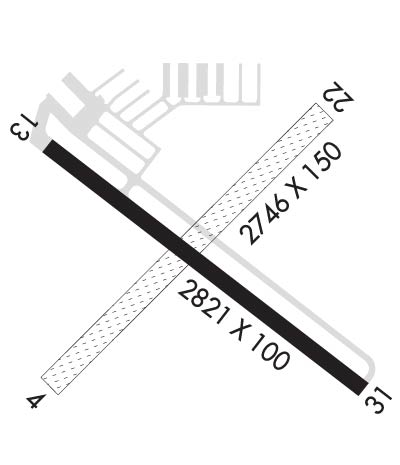
| Lat: N 4131.1 Long: W 08810.5 Elev: 582 Var: +03 Longest Runway: 2821 | ||
| AWOS: 119.97 CTAF: 122.7 | ||
| ||||||||||||||||||||||||||||||||||||||||||||||||||||||||||||||||||||
| ||||||||||||||||||||||||||||||||||||||||||||||||||||||||||||||||||||
| ||||||||||||||||||||||||||||||||||||||||||||||||||||||||||||||||||||
| Rwy | Rwy | |||||||
| 2746x150 | 2746' | 2746x150 | 2746' | |||||
| 2821x100 | 2721' | 2821x100 | 2741' | |||||
| Runway ID | Single Wheel | Double Wheel | Double Tandem Wheel | Dual Double Wheel |
| 04/22 | N/A | N/A | N/A | N/A |
| 13/31 | 8,000 | N/A | N/A | N/A |
| These numbers are Advisory and are not limits. The Airport Manager should have more accurate Weight Limits | ||||
| FltPlan does not have IFR approach charts available for KJOT. |
 Airport Diagram might not be current. | |
| Facility Name: | JOLIET RGNL |
| City Name: | JOLIET |
| County: | WILL |
| State abbrev: | IL |
| State Name: | ILLINOIS |
| Ownership: | PUBLICLY OWNED |
| Use: | OPEN TO THE PUBLIC |
| Owner's Name: | JOLIET PARK DISTRICT |
| Address: | 4000 W JEFFERSON |
| JOLIET, IL 60431 | |
| Owner's Phone: | 815-741-7275 |
| Manager's Name: | JENNIFER MCFARLAND |
| Address: | 4000 W JEFFERSON |
| JOLIET, IL 60431 | |
| Phone: | 815-741-7267 |
| FAA Region: | GREAT LAKES |
| FAA Field Office: | CHI |

| Date | Sunrise | Sunset |
|---|---|---|
| 09/24/21 Friday | 6:42 | 18:47 |
| 09/25/21 Saturday | 6:43 | 18:45 |
| 09/26/21 Sunday | 6:44 | 18:43 |
| 09/27/21 Monday | 6:45 | 18:42 |
| 09/28/21 Tuesday | 6:46 | 18:40 |
| 09/29/21 Wednesday | 6:47 | 18:38 |
| 09/30/21 Thursday | 6:48 | 18:37 |
| 10/01/21 Friday | 6:49 | 18:35 |
| 10/02/21 Saturday | 6:50 | 18:33 |
| 10/03/21 Sunday | 6:51 | 18:31 |
| 10/04/21 Monday | 6:52 | 18:30 |
| 10/05/21 Tuesday | 6:53 | 18:28 |
| 10/06/21 Wednesday | 6:55 | 18:26 |
| 10/07/21 Thursday | 6:56 | 18:25 |
| Airport Attendance Schedule | APR-OCT 7 Days A Week 0700-1800, NOV-MAR 7 Days A Week 0700-1800 |
| Airport Status | OPERATIONAL (This Status can change at any time - please check NOTAMS) |
| Airport Lighting Schedule | MIRL RY 13/31 PRESET ON LOW INTST - TO ACTVT INCR INTST PAPI RY 13; MIRL RY 13/31 - CTAF. |
| Airport Storage Available | Tie Downs, Hanger |
| Extra Services Available | Charter, Flight Instruction, Aircraft Rental, Aircraft Sales |
| Wind Indicator | YES - (lighted) |
| Control Tower | NO |
| CTAF Frequency | 122.700 |
| Unicom Frequency | 122.700 |
| Rotating Beacon Color | CLEAR-GREEN (Light Land Airport) |
| Segmented Circle | NO |
| Landing Fee | NO |
| Airport Inspected | FEDERAL - performed by STATE AERONAUTICAL PERSONNEL |
| Inspection Date | 08/16/2019 |
| Type of Fuel Available | Grade 100LL, JET A (freeze point -40C)MOGAS |
| Airframe Repair Service | MAJOR |
| Power Plant Repair Service | MAJOR |
| Latitude | N4131.1 |
| Longitude | W08810.5 (ESTIMATED) |
| Arpt Elevation | 582ft (SURVEYED) |
| Magnetic Variation | 03W |
| 4 miles W | of JOLIET |
| Traffic Pattern Altitude | |
| Sectional Chart | CHICAGO |
| Operations (Reported) | Yearly | Avg. Daily |
|---|---|---|
| General Aviation Transient | 11300 | 31 |
| General Aviation Local | 11000 | 30 |
| Air Taxi | 2000 | 5 |
| Commerical | 0 | 0 |
| Commuter | 0 | 0 |
| Military | 700 | 2 |
| Aircraft based on Field | |
|---|---|
| General Aviation Singles | 59 |
| General Aviation Multi | 1 |
| Jet Aircraft | 0 |
| General Aviation Helicopters | 3 |
| Military Aircraft | 0 |
| Gliders | 0 |
| Ultralights | 0 |
| FSS on field | NO |
| FSS tie-in | KANKAKEE |
| FSS Phone | 1-800-WX-BRIEF |
| Who issues Notams | JOT |
| Notam D service at airport | YES |
| ARTCC Name | CHICAGO |
| Airport Certification | |
| Aircraft Rescue & Firefighting Index | None |
| Airport of Entry | No |
| Custom Landing Rights | No |
| Joint Civil/Military | No |
| Military Landing rights | YES |
| NATIONAL PLAN OF INTEGRATED AIRPORT SYSTEMS (NPIAS) |
| FOR CD CTC CHICAGO APCH AT 847-289-0926. |
Airport Communications & Frequencies:
| ||||||||||||||
| Runway: 04 | Runway: 22 | ||
| Mag heading: | 47° | Mag heading: | 227° |
| Rwy Slope: | .14% Up | Rwy Slope: | -.14% Down |
| Approach: | Approach: | ||
| Pattern: | Left Traffic | Pattern: | Left Traffic |
| Markings: | Markings: | ||
| Marking Condition: | RWY 04 /22 MKD WITH TIRES PAINTED WHITE; THLD MKD WITH WHITE GRAVEL. | Marking Condition: | |
| Arresting Dev: | Arresting Dev: | ||
| Lat & Long: | N4130.9 W08810.8 | Lat. & Long.: | N4131.2 W08810.3 |
| Elev: | 574.6 ft. MSL | Elev: | 578.4 ft. MSL |
| TCH: | TCH: | ||
| Visual Glide Path: | Visual Glide Path: | ||
| Displaced Threshold: | No | Displaced Threshold: | No |
| Touchdown Zone: | YES | Touchdown Zone: | YES |
| Touchdown Elev.: | 579.8 feet | Touchdown Elev.: | 579.8 feet |
| Visual Glide Slope: | Visual Glide Slope: | ||
| RVR Equipment: | RVR Equipment: | ||
| RVV Equipment: | NO | RVV Equipment: | NO |
| Approach Lights: | Approach Lights: | ||
| REIL: | NO | REIL: | NO |
| Centerline Lights: | NO | Centerline Lights: | NO |
| Touchdown lights: | NO | Touchdown lights: | NO |
| Runway Category: | Runway with a Visual Approach | Runway Category: | Runway with a Visual Approach |
| Declared Distances: | Declared Distances: | ||
| Obstructions: | Obstructions: | TREE | |
| Marked: | Marked: | NOT Marked/Lighted | |
| Clearance slope: | 20:1 | Clearance slope: | 14:1 |
| Obstruction height: | Obstruction height: | 47 feet AGL | |
| Dist. from runway: | Dist. from runway: | 679 feet | |
| Centerline offset: | Centerline offset: | 105 feet right of centerline | |
| Comments: | Comments: |
| Runway: 13 | Runway: 31 | ||
| Mag heading: | 130° | Mag heading: | 310° |
| Rwy Slope: | -.11% Down | Rwy Slope: | .11% Up |
| Approach: | Approach: | ||
| Pattern: | Left Traffic | Pattern: | Left Traffic |
| Markings: | NONPRECISION INSTRUMENT | Markings: | NONPRECISION INSTRUMENT |
| Marking Condition: | GOOD | Marking Condition: | GOOD |
| Arresting Dev: | Arresting Dev: | ||
| Lat & Long: | N4131.2 W08810.8 | Lat. & Long.: | N4130.9 W08810.3 |
| Elev: | 580.5 ft. MSL | Elev: | 577.4 ft. MSL |
| TCH: | 41 ft. AGL | TCH: | |
| Visual Glide Path: | 3.50 degrees | Visual Glide Path: | |
| Displaced Threshold: | 100 feet | Displaced Threshold: | 80 feet |
| Touchdown Zone: | YES | Touchdown Zone: | YES |
| Touchdown Elev.: | 582.3 feet | Touchdown Elev.: | 582.3 feet |
| Visual Glide Slope: | 4-Light PAPI on RIGHT side of Runway | Visual Glide Slope: | |
| RVR Equipment: | RVR Equipment: | ||
| RVV Equipment: | NO | RVV Equipment: | NO |
| Approach Lights: | Approach Lights: | ||
| REIL: | NO | REIL: | NO |
| Centerline Lights: | NO | Centerline Lights: | NO |
| Touchdown lights: | NO | Touchdown lights: | NO |
| Runway Category: | Runway with a Visual Approach | Runway Category: | Runway with a Visual Approach |
| Declared Distances: | Declared Distances: | ||
| Obstructions: | TREE | Obstructions: | TREE |
| Marked: | NOT Marked/Lighted | Marked: | NOT Marked/Lighted |
| Clearance slope: | 10:1; APCH RATIO 21:1 TO DSPLCD THLD. | Clearance slope: | 7:1; APCH RATIO 12:1 TO DSPLCD THLD. |
| Obstruction height: | 49 feet AGL | Obstruction height: | 73 feet AGL |
| Dist. from runway: | 730 feet | Dist. from runway: | 719 feet |
| Centerline offset: | 210 left of centerline | Centerline offset: | 132 feet right of centerline |
| Comments: | Comments: |
Thanks for using FltPlan.com
all rights reserved © 1999-2021 by Flight Plan LLC