
| JOHNSTON COUNTY SMITHFIELD NC |
| |
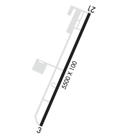
| Lat: N 3532.5 Long: W 07823.4 Elev: 164 Var: +09 Longest Runway: 5500 | ||
| Clr Del: GCO 135.07 AWOS: 120.22 CTAF: 122.72 | ||
| ||||||
| ||||||
|
| Rwy | Rwy | |||||||
| 5500x100 | 5500' | 111.15 - 032° | 5500x100 | 5500' | ||||
| Runway ID | Single Wheel | Double Wheel | Double Tandem Wheel | Dual Double Wheel |
| 03/21 | 65,000 | 65,000 | N/A | N/A |
| These numbers are Advisory and are not limits. The Airport Manager should have more accurate Weight Limits | ||||
 Airport Diagram might not be current. | |
| Facility Name: | JOHNSTON RGNL |
| City Name: | SMITHFIELD |
| County: | JOHNSTON |
| State abbrev: | NC |
| State Name: | NORTH CAROLINA |
| Ownership: | PUBLICLY OWNED |
| Use: | OPEN TO THE PUBLIC |
| Owner's Name: | JOHNSTON CO ARPT AUTH |
| Address: | 3149 SWIFT CREEK RD |
| SMITHFIELD, NC 27577-9803 | |
| Owner's Phone: | 919-934-0992 |
| Manager's Name: | PHIL LANIER |
| Address: | 3149 SWIFT CREEK RD |
| SMITHFIELD, NC 27577-9803 | |
| Phone: | 919-934-0992 |
| FAA Region: | SOUTHERN |
| FAA Field Office: | MEM |

| Date | Sunrise | Sunset |
|---|---|---|
| 09/24/21 Friday | 7:03 | 19:08 |
| 09/25/21 Saturday | 7:04 | 19:06 |
| 09/26/21 Sunday | 7:04 | 19:05 |
| 09/27/21 Monday | 7:05 | 19:03 |
| 09/28/21 Tuesday | 7:06 | 19:02 |
| 09/29/21 Wednesday | 7:07 | 19:01 |
| 09/30/21 Thursday | 7:07 | 18:59 |
| 10/01/21 Friday | 7:08 | 18:58 |
| 10/02/21 Saturday | 7:09 | 18:56 |
| 10/03/21 Sunday | 7:10 | 18:55 |
| 10/04/21 Monday | 7:11 | 18:53 |
| 10/05/21 Tuesday | 7:11 | 18:52 |
| 10/06/21 Wednesday | 7:12 | 18:51 |
| 10/07/21 Thursday | 7:13 | 18:49 |
| Airport Attendance Schedule | 7 Days A Week 0800-1800; UNATNDD THANKSGIVING AND CHRISTMAS DAY. |
| Airport Status | OPERATIONAL (This Status can change at any time - please check NOTAMS) |
| Airport Lighting Schedule | ACTVT MALSR RWY 03; REIL RWY 21 AND TWY LGTS; MIRL 3/21 - CTAF. PAPI RWY 03 & 21 OPER CONSLY. |
| Airport Storage Available | Tie Downs |
| Extra Services Available | Air Ambulance, Avionics, Flight Instruction, Aircraft Rental |
| Wind Indicator | YES - (lighted) |
| Control Tower | NO |
| CTAF Frequency | 122.725 |
| Unicom Frequency | 122.725 |
| Rotating Beacon Color | CLEAR-GREEN (Light Land Airport) |
| Segmented Circle | YES |
| Landing Fee | NO |
| Airport Inspected | STATE - performed by STATE AERONAUTICAL PERSONNEL |
| Inspection Date | 08/13/2020 |
| Type of Fuel Available | Grade 100LL, JET A-1 (icing inhibitor, freeze point -50C) |
| Airframe Repair Service | MAJOR |
| Power Plant Repair Service | MAJOR |
| Latitude | N3532.5 |
| Longitude | W07823.4 (ESTIMATED) |
| Arpt Elevation | 164ft (SURVEYED) |
| Magnetic Variation | 09W |
| 3 miles NW | of SMITHFIELD |
| Traffic Pattern Altitude | 1035 |
| Sectional Chart | CHARLOTTE |
| Operations (Reported) | Yearly | Avg. Daily |
|---|---|---|
| General Aviation Transient | 32000 | 88 |
| General Aviation Local | 40350 | 111 |
| Air Taxi | 0 | 0 |
| Commerical | 0 | 0 |
| Commuter | 0 | 0 |
| Military | 1000 | 3 |
| Aircraft based on Field | |
|---|---|
| General Aviation Singles | 80 |
| General Aviation Multi | 7 |
| Jet Aircraft | 5 |
| General Aviation Helicopters | 1 |
| Military Aircraft | 0 |
| Gliders | 0 |
| Ultralights | 0 |
| FSS on field | NO |
| FSS tie-in | RALEIGH |
| FSS Phone | 1-800-WX-BRIEF |
| Who issues Notams | JNX |
| Notam D service at airport | YES |
| ARTCC Name | WASHINGTON |
| Airport Certification | |
| Aircraft Rescue & Firefighting Index | None |
| Airport of Entry | No |
| Custom Landing Rights | No |
| Joint Civil/Military | No |
| Military Landing rights | YES |
| NATIONAL PLAN OF INTEGRATED AIRPORT SYSTEMS (NPIAS) |
| GRANT AGREEMENTS UNDER FAAP/ADAP/AIP |
| ASSURANCES PURSUANT TO TITLE VI, CIVIL RIGHTS ACT OF 1964 |
| AVOID OVERFLIGHTS OF HOUSING AREA IN TFC PAT FOR NOISE ABATEMENT. FLY WIDER DNWNDS & LONGER DEP LEGS. |
| GCO AVBL ON FREQ 135.075 THRU RDU CD & FLT SVCS. |
| BE ALERT WHEN TAXING NEAR SOUTH RAMP/CORPORATE HNGR. |
| KEY CODE ACCESS TO PILOT LOUNGE AT PILOT/CREW RAMP |
| HEL FLT T OPS INVOF ARPT. |
| GPU AVBL. |
| FOR CD IF RALEIGH APCH UNA VIA GCO CTC WASHINGTON ARTCC AT 703-771-3587. |
| DEER AND COYOTE ON & INVOF ARPT. |
| RWY 21 HAS +65 FT UNMKD PWR LN 2000 FT FM THR LEFT AND RIGHT OF CNTRLN. |
| 50 FT AGL TWR 200 FT SW OF RWY 03 CNTRLN. |
| RWY 03/2 1 HAS A 150 FT STOPWAY ON BOTH ENDS. |
Airport Communications & Frequencies:
| ||||||||||||||
| Runway: 03 | Runway: 21 | ||
| Mag heading: | 32° | Mag heading: | 212° |
| Rwy Slope: | .31% Up | Rwy Slope: | -.31% Down |
| Approach: | ILS/DME | Approach: | |
| Pattern: | Left Traffic | Pattern: | Left Traffic |
| Markings: | PRECISION INSTRUMENT | Markings: | NONPRECISION INSTRUMENT |
| Marking Condition: | GOOD | Marking Condition: | GOOD |
| Arresting Dev: | Arresting Dev: | ||
| Lat & Long: | N3532.0 W07823.6 | Lat. & Long.: | N3532.9 W07823.2 |
| Elev: | 146.9 ft. MSL | Elev: | 164.0 ft. MSL |
| TCH: | 45 ft. AGL | TCH: | 49 ft. AGL |
| Visual Glide Path: | 3.00 degrees | Visual Glide Path: | 4.00 degrees |
| Displaced Threshold: | No | Displaced Threshold: | No |
| Touchdown Zone: | YES | Touchdown Zone: | YES |
| Touchdown Elev.: | 146.9 feet | Touchdown Elev.: | 164.0 feet |
| Visual Glide Slope: | 4-Light PAPI on LEFT side of Runway | Visual Glide Slope: | 4-Light PAPI on LEFT side of Runway |
| RVR Equipment: | RVR Equipment: | ||
| RVV Equipment: | NO | RVV Equipment: | NO |
| Approach Lights: | MALSR - 1,400 foot medium intensity approach lighting system with runway alignment indicator lights | Approach Lights: | |
| REIL: | NO | REIL: | YES |
| Centerline Lights: | NO | Centerline Lights: | NO |
| Touchdown lights: | NO | Touchdown lights: | NO |
| Runway Category: | Precision Instrument Runway | Runway Category: | Runway with a Non-precision Approach having visibility minimums greater than 3/4 mile |
| Declared Distances: | Declared Distances: | ||
| Obstructions: | TREES | Obstructions: | TREES |
| Marked: | NOT Marked/Lighted | Marked: | NOT Marked/Lighted |
| Clearance slope: | 1:1 | Clearance slope: | 4:1 |
| Obstruction height: | 58 feet AGL | Obstruction height: | 15 feet AGL |
| Dist. from runway: | 294 feet | Dist. from runway: | 264 feet |
| Centerline offset: | 504 right of centerline | Centerline offset: | 370 feet right of centerline |
| Comments: | 31 FT TREES 0-200 FT FROM THLD OFFSET 418 FT LEFT OF CNTLN, AND 64 FT TREES 0-200 FT FROM THLD OFFSET 472 FT RIGHT OF CNTLN. | Comments: | 6 FT GROUND 0-200 FT FR THR OFFSET 301 LEFT OF CNTRLN |
Thanks for using FltPlan.com
all rights reserved © 1999-2021 by Flight Plan LLC