
| JAMESTOWN RGNL JAMESTOWN ND |
| |
| Lat: N 4655.8 Long: W 09840.7 Elev: 1500 Var: -04 Longest Runway: 6502 | ||
| AWOS: 118.42 CTAF: 123.0 | ||
| ||||||||||||||||||||||||||||||||||||||||||||
| ||||||||||||||||||||||||||||||||||||||||||||
| ||||||||||||||||||||||||||||||||||||||||||||
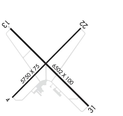
| Rwy | Rwy | |||||||
| 5750x75 | 5750' | 5750x75 | 5750' | |||||
| 6502x100 | 6502' | 6502x100 | 6502' | 109.30 - 310° | ||||
| Runway ID | Single Wheel | Double Wheel | Double Tandem Wheel | Dual Double Wheel |
| 04/22 | 85,000 | 103,000 | 162,000 | N/A |
| 13/31 | 130,000 | 160,000 | 250,000 | N/A |
| These numbers are Advisory and are not limits. The Airport Manager should have more accurate Weight Limits | ||||
 Airport Diagram might not be current. | |
| Facility Name: | JAMESTOWN RGNL |
| City Name: | JAMESTOWN |
| County: | STUTSMAN |
| State abbrev: | ND |
| State Name: | NORTH DAKOTA |
| Ownership: | PUBLICLY OWNED |
| Use: | OPEN TO THE PUBLIC |
| Owner's Name: | JAMESTOWN RGNL ARPT AUTHORITY |
| Address: | PO BOX 1560 |
| JAMESTOWN, ND 58402 | |
| Owner's Phone: | 701-252-6466 |
| Manager's Name: | KATIE HEMMER |
| Address: | PO BOX 1560 |
| JAMESTOWN, ND 58402 | |
| Phone: | 701-252-6466 |
| FAA Region: | GREAT LAKES |
| FAA Field Office: | DMA |
| Date | Sunrise | Sunset |
|---|---|---|
| 06/12/26 Friday | 5:40 | 21:30 |
| 06/13/26 Saturday | 5:39 | 21:30 |
| 06/14/26 Sunday | 5:39 | 21:31 |
| 06/15/26 Monday | 5:39 | 21:31 |
| 06/16/26 Tuesday | 5:39 | 21:32 |
| 06/17/26 Wednesday | 5:39 | 21:32 |
| 06/18/26 Thursday | 5:39 | 21:32 |
| 06/19/26 Friday | 5:39 | 21:33 |
| 06/20/26 Saturday | 5:40 | 21:33 |
| 06/21/26 Sunday | 5:40 | 21:33 |
| 06/22/26 Monday | 5:40 | 21:33 |
| 06/23/26 Tuesday | 5:40 | 21:33 |
| 06/24/26 Wednesday | 5:41 | 21:34 |
| 06/25/26 Thursday | 5:41 | 21:34 |
| Airport Attendance Schedule | MON-FRI 0800-1700 |
| Airport Status | OPERATIONAL (This Status can change at any time - please check NOTAMS) |
| Airport Lighting Schedule | ACTVT MALSR RWY 31; REIL RWYS 04, 13, & 22; MIRL RWY 04/22; HIRL RWY 13/31 - CTAF. PAPI RWYS 04, 13, 22, & 31 OPR CONSLY. |
| Airport Storage Available | Tie Downs, Hanger |
| Extra Services Available | Crop Dusting, Air Ambulance, Charter, Flight Instruction, Aircraft Rental, Aircraft Sales, Annual Surveying |
| Wind Indicator | YES - (lighted) |
| Control Tower | NO |
| CTAF Frequency | 123.000 |
| Unicom Frequency | 123.000 |
| Rotating Beacon Color | WG |
| Segmented Circle | YES |
| Landing Fee | NO |
| Airport Inspected | FEDERAL - performed by FAA AIRPORTS FIELD PERSONNEL |
| Inspection Date | 09/17/2025 |
| Type of Fuel Available | Grade 100LL, JET A (freeze point -40C); -10100LL AVBL 24 HRS WITH CREDIT CARD. 24 HR PILOT LOUNGE AVBL. |
| Airframe Repair Service | MAJOR |
| Power Plant Repair Service | MAJOR |
| Latitude | N4655.8 |
| Longitude | W09840.7 (ESTIMATED) |
| Arpt Elevation | 1499ft (SURVEYED) |
| Magnetic Variation | 04E |
| 2 miles NE | of JAMESTOWN |
| Traffic Pattern Altitude | |
| Sectional Chart | TWIN CITIES |
| Operations (Reported) | Yearly | Avg. Daily |
|---|---|---|
| General Aviation Transient | 0 | 0 |
| General Aviation Local | 0 | 0 |
| Air Taxi | 0 | 0 |
| Commerical | 0 | 0 |
| Commuter | 0 | 0 |
| Military | 0 | 0 |
| Aircraft based on Field | |
|---|---|
| General Aviation Singles | 0 |
| General Aviation Multi | 0 |
| Jet Aircraft | 0 |
| General Aviation Helicopters | 0 |
| Military Aircraft | 0 |
| Gliders | 0 |
| Ultralights | 0 |
| FSS on field | NO |
| FSS tie-in | GRAND FORKS |
| FSS Phone | 1-800-WX-BRIEF |
| Who issues Notams | JMS |
| Notam D service at airport | YES |
| ARTCC Name | MINNEAPOLIS |
| Airport Certification | AIRPORT RECEIVING SCHEDULED AIR CARRIER SERVICE FROM CARRIERS CERTIFICATED BY THE CIVIL AERONAUTICS BOARD; 48 HRS PPR FOR UNSKED ACR OPNS WITH MORE THAN 30 PSGR SEATS CALL AMGR 701-252-6466. ACR OPS INVOLVING ACFT WITH MORE THAN 9 PSGRS NOT AUZD IN EXCESS OF 15 MINS BEFORE OR AFTER SKED ARR/DEP TIMES WITHOUT PRIOR COORDINATION WITH AMGR AND CONFIRMATION THAT ARFF IS AVBL PRIOR TO LANDING OR TAKEOFF. |
| Aircraft Rescue & Firefighting Index | AIRPORT HAS A CERTIFICATE UNDER CFR PART 139 |
| Airport of Entry | No |
| Custom Landing Rights | No |
| Joint Civil/Military | No |
| Military Landing rights | YES |
| NATIONAL PLAN OF INTEGRATED AIRPORT SYSTEMS (NPIAS) |
| GRANT AGREEMENTS UNDER FAAP/ADAP/AIP |
| ASSURANCES PURSUANT TO TITLE VI, CIVIL RIGHTS ACT OF 1964 |
| AGREEMENT UNDER DLAND OR DCLA HAS EXPIRED. |
| THIS AIRPORT HAS BEEN SURVEYED BY THE NATIONAL GEODETIC SURVEY. |
| BIRDS ON AND INVOF ARPT. |
| FBO FUELING AFTER HOURS PHONE 701-952-1515. |
| FOR CD IF UNA TO CTC ON FSS FREQ, CTC MINNEAPOLIS ARTCC AT 651-463-5588. |
| RWY 04/2 2 PCR VALUE: 80/F/D/X/T |
| RWY 13/3 1 PCR VALUE: 490/F/C/X/T |
Airport Communications & Frequencies:
| |||||||||
| Runway: 04 | Runway: 22 | ||
| Mag heading: | 41° | Mag heading: | 221° |
| Rwy Slope: | .10% Up | Rwy Slope: | -.10% Down |
| Approach: | Approach: | ||
| Pattern: | Left Traffic | Pattern: | Left Traffic |
| Markings: | NONPRECISION INSTRUMENT | Markings: | NONPRECISION INSTRUMENT |
| Marking Condition: | GOOD | Marking Condition: | GOOD |
| Arresting Dev: | Arresting Dev: | ||
| Lat & Long: | N4655.5 W09841.2 | Lat. & Long.: | N4656.1 W09840.2 |
| Elev: | 1493.8 ft. MSL | Elev: | 1499.6 ft. MSL |
| TCH: | 22 ft. AGL | TCH: | 21 ft. AGL |
| Visual Glide Path: | 3.00 degrees | Visual Glide Path: | 3.00 degrees |
| Displaced Threshold: | No | Displaced Threshold: | No |
| Touchdown Zone: | YES | Touchdown Zone: | YES |
| Touchdown Elev.: | 1495.8 feet | Touchdown Elev.: | 1499.9 feet |
| Visual Glide Slope: | 4-Light PAPI on LEFT side of Runway | Visual Glide Slope: | 4-Light PAPI on LEFT side of Runway |
| RVR Equipment: | RVR Equipment: | ||
| RVV Equipment: | NO | RVV Equipment: | NO |
| Approach Lights: | Approach Lights: | ||
| REIL: | YES | REIL: | YES |
| Centerline Lights: | NO | Centerline Lights: | NO |
| Touchdown lights: | NO | Touchdown lights: | NO |
| Runway Category: | Runway with a Non-precision Approach having visibility minimums greater than 3/4 mile | Runway Category: | D |
| Declared Distances: | TORA:5750' TODA:5750' ASDA:5750' LDA:5750' | Declared Distances: | TORA:5750' TODA:5750' ASDA:5750' LDA:5750' |
| Runway: 13 | Runway: 31 | ||
| Mag heading: | 131° | Mag heading: | 311° |
| Rwy Slope: | -.04% Down | Rwy Slope: | .04% Up |
| Approach: | Approach: | ILS | |
| Pattern: | Left Traffic | Pattern: | Left Traffic |
| Markings: | NONPRECISION INSTRUMENT | Markings: | PRECISION INSTRUMENT |
| Marking Condition: | GOOD | Marking Condition: | GOOD |
| Arresting Dev: | Arresting Dev: | ||
| Lat & Long: | N4656.1 W09841.2 | Lat. & Long.: | N4655.4 W09840.1 |
| Elev: | 1499.8 ft. MSL | Elev: | 1496.9 ft. MSL |
| TCH: | 49 ft. AGL | TCH: | 52 ft. AGL |
| Visual Glide Path: | 3.00 degrees | Visual Glide Path: | 3.00 degrees |
| Displaced Threshold: | No | Displaced Threshold: | No |
| Touchdown Zone: | YES | Touchdown Zone: | YES |
| Touchdown Elev.: | 1499.8 feet | Touchdown Elev.: | 1497.5 feet |
| Visual Glide Slope: | 4-Light PAPI on LEFT side of Runway | Visual Glide Slope: | 4-Light PAPI on LEFT side of Runway |
| RVR Equipment: | RVR Equipment: | ||
| RVV Equipment: | NO | RVV Equipment: | NO |
| Approach Lights: | Approach Lights: | MALSR - 1,400 foot medium intensity approach lighting system with runway alignment indicator lights | |
| REIL: | YES | REIL: | NO |
| Centerline Lights: | NO | Centerline Lights: | NO |
| Touchdown lights: | NO | Touchdown lights: | NO |
| Runway Category: | Runway with a Non-precision Approach having visibility minimums greater than 3/4 mile | Runway Category: | Precision Instrument Runway |
| Declared Distances: | TORA:6502' TODA:6502' ASDA:6502' LDA:6502' | Declared Distances: | TORA:6502' TODA:6502' ASDA:6502' LDA:6502' |
| Obstructions: | TREE | Obstructions: | |
| Marked: | NOT Marked/Lighted | Marked: | |
| Clearance slope: | 37:1 | Clearance slope: | 50:1 |
| Obstruction height: | 46 feet AGL | Obstruction height: | |
| Dist. from runway: | 1927 feet | Dist. from runway: | |
| Centerline offset: | 70 right of centerline | Centerline offset: | |
| Comments: | Comments: |
Thanks for using FltPlan.com
all rights reserved © 1999-2026 by Flight Plan LLC
