
| JOPLIN RGNL JOPLIN MO |
| |
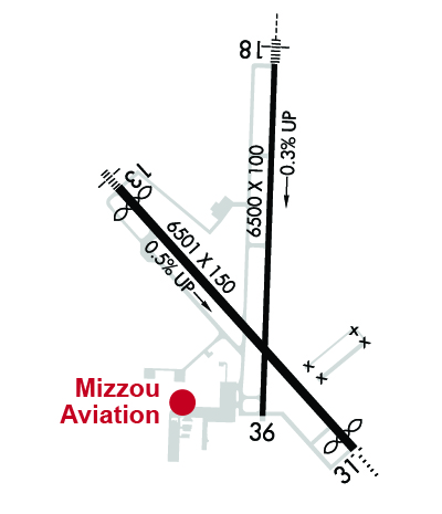
| Lat: N 3709.2 Long: W 09429.9 Elev: 978 Var: -04 Longest Runway: 6501 | ||
| Dept. ATIS: 120.85 Arr. ATIS: 120.85 Ground: 121.6 Tower: 119.8 | ||
| |||||||||||||||||||||||||||||||||||||||||||||||||||||||||||||
| |||||||||||||||||||||||||||||||||||||||||||||||||||||||||||||
| |||||||||||||||||||||||||||||||||||||||||||||||||||||||||||||
| Rwy | Rwy | |||||||
| 6501x150 | 6113' | 110.30 - 133° | 6501x150 | 6202' | ||||
| 6501x100 | 6501' | 108.90 - 178° | 6501x100 | 6501' | ||||
| Runway ID | Single Wheel | Double Wheel | Double Tandem Wheel | Dual Double Wheel |
| 13/31 | 80,000 | 105,000 | 170,000 | N/A |
| 18/36 | 30,000 | 60,000 | N/A | N/A |
| These numbers are Advisory and are not limits. The Airport Manager should have more accurate Weight Limits | ||||
 Airport Diagram might not be current. | |
| Facility Name: | JOPLIN RGNL |
| City Name: | JOPLIN |
| County: | JASPER |
| State abbrev: | MO |
| State Name: | MISSOURI |
| Ownership: | PUBLICLY OWNED |
| Use: | OPEN TO THE PUBLIC |
| Owner's Name: | CITY OF JOPLIN |
| Address: | 602 S. MAIN STREET |
| JOPLIN, MO 64802-1355 | |
| Owner's Phone: | 417-624-0820 |
| Manager's Name: | MR. STEVE STOCKAM |
| Address: | 602 S. MAIN STREET |
| JOPLIN, MO 64802 | |
| Phone: | 417-623-0262 |
| FAA Region: | CENTRAL |
| FAA Field Office: | NONE |
| Date | Sunrise | Sunset |
|---|---|---|
| 09/24/21 Friday | 7:07 | 19:12 |
| 09/25/21 Saturday | 7:08 | 19:11 |
| 09/26/21 Sunday | 7:09 | 19:09 |
| 09/27/21 Monday | 7:10 | 19:08 |
| 09/28/21 Tuesday | 7:11 | 19:06 |
| 09/29/21 Wednesday | 7:11 | 19:05 |
| 09/30/21 Thursday | 7:12 | 19:03 |
| 10/01/21 Friday | 7:13 | 19:02 |
| 10/02/21 Saturday | 7:14 | 19:00 |
| 10/03/21 Sunday | 7:15 | 18:59 |
| 10/04/21 Monday | 7:16 | 18:57 |
| 10/05/21 Tuesday | 7:17 | 18:56 |
| 10/06/21 Wednesday | 7:18 | 18:54 |
| 10/07/21 Thursday | 7:18 | 18:53 |
| Airport Attendance Schedule | 7 Days A Week 0500-0000 |
| Airport Status | OPERATIONAL (This Status can change at any time - please check NOTAMS) |
| Airport Lighting Schedule | WHEN ATCT CLSD ACTVT MALSF RWY 13; ODALS RWY 31; HIRL RWY 13/31 - CTAF. MALSR RWY 18; PAPI RWY 31 AND 36; HIRL RWY 18/36 - OPR DUSK-DAWN. |
| Airport Storage Available | Tie Downs, Hanger |
| Extra Services Available | Air Freight, Air Ambulance, Charter, Flight Instruction, Aircraft Rental, Aircraft Sales |
| Wind Indicator | YES - (lighted) |
| Control Tower | YES |
| CTAF Frequency | 119.800 |
| Unicom Frequency | 122.950 |
| Rotating Beacon Color | CLEAR-GREEN (Light Land Airport) |
| Segmented Circle | NO |
| Landing Fee | NO |
| Airport Inspected | FEDERAL - performed by FAA AIRPORTS FIELD PERSONNEL |
| Inspection Date | 01/14/2020 |
| Type of Fuel Available | Grade 100LL, JET A (freeze point -40C) |
| Airframe Repair Service | MAJOR |
| Power Plant Repair Service | MAJOR |
| Latitude | N3709.2 |
| Longitude | W09429.9 (ESTIMATED) |
| Arpt Elevation | 977ft (ESTIMATED) |
| Magnetic Variation | 04E |
| 4 miles N | of JOPLIN |
| Traffic Pattern Altitude | |
| Sectional Chart | KANSAS CITY |
| Operations (Reported) | Yearly | Avg. Daily |
|---|---|---|
| General Aviation Transient | 3725 | 10 |
| General Aviation Local | 18624 | 51 |
| Air Taxi | 0 | 0 |
| Commerical | 1588 | 4 |
| Commuter | 0 | 0 |
| Military | 93 | 0 |
| Aircraft based on Field | |
|---|---|
| General Aviation Singles | 105 |
| General Aviation Multi | 10 |
| Jet Aircraft | 8 |
| General Aviation Helicopters | 2 |
| Military Aircraft | 0 |
| Gliders | 0 |
| Ultralights | 3 |
| FSS on field | NO |
| FSS tie-in | COLUMBIA |
| FSS Phone | 1-800-WX-BRIEF |
| Who issues Notams | JLN |
| Notam D service at airport | YES |
| ARTCC Name | KANSAS CITY |
| Airport Certification | AIRPORT RECEIVING SCHEDULED AIR CARRIER SERVICE FROM CARRIERS CERTIFICATED BY THE CIVIL AERONAUTICS BOARD; PPR 48 HRS FOR UNSKED ACR OPNS WITH MORE THAN 30 PSGR SEATS CALL AMGR 417-623-0262. |
| Aircraft Rescue & Firefighting Index | AIRPORT HAS A CERTIFICATE UNDER CFR PART 139 |
| Airport of Entry | No |
| Custom Landing Rights | No |
| Joint Civil/Military | No |
| Military Landing rights | YES |
| NATIONAL PLAN OF INTEGRATED AIRPORT SYSTEMS (NPIAS) |
| GRANT AGREEMENTS UNDER FAAP/ADAP/AIP |
| ASSURANCES PURSUANT TO TITLE VI, CIVIL RIGHTS ACT OF 1964 |
| AGREEMENT UNDER DLAND OR DCLA HAS EXPIRED. |
| BIRDS ON & INVOF ARPT SPRING & FALL. |
| PPR 48 HRS FOR ACFT CARRYING HAZARDOUS OR EXPLOSIVE CARGO. |
| FOR CD IF UNA TO CTC ON FSS FREQ, CTC KANSAS CITY ARTCC AT 913-254-8508. |
Airport Communications & Frequencies:
| |||||||||||||||
| Runway: 13 | Runway: 31 | ||
| Mag heading: | 134° | Mag heading: | 314° |
| Rwy Slope: | .45% Up | Rwy Slope: | -.45% Down |
| Approach: | ILS | Approach: | |
| Pattern: | Left Traffic | Pattern: | Left Traffic |
| Markings: | PRECISION INSTRUMENT | Markings: | NONPRECISION INSTRUMENT |
| Marking Condition: | FAIR | Marking Condition: | FAIR |
| Arresting Dev: | Arresting Dev: | ||
| Lat & Long: | N3709.5 W09430.4 | Lat. & Long.: | N3708.7 W09429.5 |
| Elev: | 947.1 ft. MSL | Elev: | 976.6 ft. MSL |
| TCH: | TCH: | 47 ft. AGL | |
| Visual Glide Path: | Visual Glide Path: | 3.00 degrees | |
| Displaced Threshold: | 388 feet | Displaced Threshold: | 299 feet |
| Touchdown Zone: | YES | Touchdown Zone: | YES |
| Touchdown Elev.: | 969.5 feet | Touchdown Elev.: | 977.7 feet |
| Visual Glide Slope: | Visual Glide Slope: | 4-Light PAPI on LEFT side of Runway | |
| RVR Equipment: | RVR Equipment: | ||
| RVV Equipment: | YES | RVV Equipment: | NO |
| Approach Lights: | MALSF - 1,400 foot medium intensity approach lighting system with sequenced flashers | Approach Lights: | ODALS - omnidirectional approach lighting system |
| REIL: | NO | REIL: | NO |
| Centerline Lights: | NO | Centerline Lights: | NO |
| Touchdown lights: | NO | Touchdown lights: | NO |
| Runway Category: | Precision Instrument Runway | Runway Category: | D |
| Declared Distances: | TORA:6500' TODA:6500' ASDA:6201' LDA:5813' | Declared Distances: | TORA:6500' TODA:6500' ASDA:6112' LDA:5813' |
| Obstructions: | TREE | Obstructions: | TREE |
| Marked: | NOT Marked/Lighted | Marked: | NOT Marked/Lighted |
| Clearance slope: | 17:1; APCH RATIO FROM DSPLCD THR 33:1 | Clearance slope: | 21:1; APCH RATIO FROM DSPLCD THR 32:1 |
| Obstruction height: | 36 feet AGL | Obstruction height: | 47 feet AGL |
| Dist. from runway: | 825 feet | Dist. from runway: | 1200 feet |
| Centerline offset: | 490 right of centerline | Centerline offset: | 300 feet left of centerline |
| Comments: | Comments: |
| Runway: 18 | Runway: 36 | ||
| Mag heading: | 178° | Mag heading: | 358° |
| Rwy Slope: | .33% Up | Rwy Slope: | -.33% Down |
| Approach: | ILS/DME | Approach: | |
| Pattern: | Left Traffic | Pattern: | Left Traffic |
| Markings: | PRECISION INSTRUMENT | Markings: | NONPRECISION INSTRUMENT |
| Marking Condition: | FAIR | Marking Condition: | FAIR |
| Arresting Dev: | Arresting Dev: | ||
| Lat & Long: | N3709.8 W09429.8 | Lat. & Long.: | N3708.8 W09429.9 |
| Elev: | 949.5 ft. MSL | Elev: | 971.0 ft. MSL |
| TCH: | TCH: | 38 ft. AGL | |
| Visual Glide Path: | Visual Glide Path: | 3.00 degrees | |
| Displaced Threshold: | No | Displaced Threshold: | No |
| Touchdown Zone: | YES | Touchdown Zone: | YES |
| Touchdown Elev.: | 964.5 feet | Touchdown Elev.: | 972.6 feet |
| Visual Glide Slope: | Visual Glide Slope: | 4-Light PAPI on LEFT side of Runway | |
| RVR Equipment: | TOUCHDOWN | RVR Equipment: | ROLLOUT |
| RVV Equipment: | NO | RVV Equipment: | NO |
| Approach Lights: | MALSR - 1,400 foot medium intensity approach lighting system with runway alignment indicator lights | Approach Lights: | |
| REIL: | NO | REIL: | NO |
| Centerline Lights: | NO | Centerline Lights: | NO |
| Touchdown lights: | NO | Touchdown lights: | NO |
| Runway Category: | Precision Instrument Runway | Runway Category: | Runway with a Non-precision Approach having visibility minimums greater than 3/4 mile |
| Declared Distances: | TORA:6499' TODA:6499' ASDA:6499' LDA:6499' | Declared Distances: | TORA:6499' TODA:6499' ASDA:6499' LDA:6499' |
| Obstructions: | POLE | Obstructions: | |
| Marked: | NOT Marked/Lighted | Marked: | |
| Clearance slope: | 31:1 | Clearance slope: | 50:1 |
| Obstruction height: | 15 feet AGL | Obstruction height: | |
| Dist. from runway: | 675 feet | Dist. from runway: | |
| Centerline offset: | 400 right of centerline | Centerline offset: | |
| Comments: | Comments: |
Thanks for using FltPlan.com
all rights reserved © 1999-2021 by Flight Plan LLC