
| JULIAN CARROLL JACKSON KY |
| |
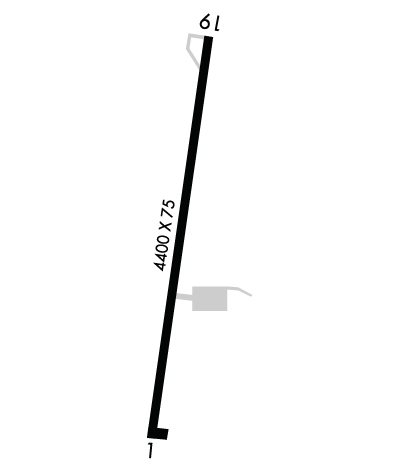
| Lat: N 3735.6 Long: W 08319.0 Elev: 1381 Var: +04 Longest Runway: 4400 | ||
| AWOS: 118.37 CTAF: 122.8 | ||
| ||||||
| ||||||
|
| Rwy | Rwy | |||||||
| 4400x75 | 4400' | 4400x75 | 4400' | |||||
| Runway ID | Single Wheel | Double Wheel | Double Tandem Wheel | Dual Double Wheel |
| 01/19 | 12,500 | N/A | N/A | N/A |
| These numbers are Advisory and are not limits. The Airport Manager should have more accurate Weight Limits | ||||
 Airport Diagram might not be current. | |
| Facility Name: | JULIAN CARROLL |
| City Name: | JACKSON |
| County: | BREATHITT |
| State abbrev: | KY |
| State Name: | KENTUCKY |
| Ownership: | PUBLICLY OWNED |
| Use: | OPEN TO THE PUBLIC |
| Owner's Name: | JACKSON-BREATHITT COUNTY |
| Address: | 208 AIRPORT ROAD |
| JACKSON, KY 41339 | |
| Owner's Phone: | (606) 666-3800 |
| Manager's Name: | JOHNNY DEATON; ARPT BOARD CHAIRMAN JOHNNY MACO DEATON |
| Address: | 208 AIRPORT ROAD; AIRPORT ADDRESS 1333 AIRPORT ROAD, JACKSON KY 41339 |
| JACKSON, KY 41339 | |
| Phone: | (606) 568-5356 |
| FAA Region: | SOUTHERN |
| FAA Field Office: | MEM |

| Date | Sunrise | Sunset |
|---|---|---|
| 09/24/21 Friday | 7:23 | 19:27 |
| 09/25/21 Saturday | 7:23 | 19:26 |
| 09/26/21 Sunday | 7:24 | 19:24 |
| 09/27/21 Monday | 7:25 | 19:23 |
| 09/28/21 Tuesday | 7:26 | 19:21 |
| 09/29/21 Wednesday | 7:27 | 19:20 |
| 09/30/21 Thursday | 7:28 | 19:18 |
| 10/01/21 Friday | 7:29 | 19:17 |
| 10/02/21 Saturday | 7:29 | 19:15 |
| 10/03/21 Sunday | 7:30 | 19:14 |
| 10/04/21 Monday | 7:31 | 19:12 |
| 10/05/21 Tuesday | 7:32 | 19:11 |
| 10/06/21 Wednesday | 7:33 | 19:09 |
| 10/07/21 Thursday | 7:34 | 19:08 |
| Airport Attendance Schedule | UNATTENDED |
| Airport Status | OPERATIONAL (This Status can change at any time - please check NOTAMS) |
| Airport Lighting Schedule | ACTVT MIRL RY 01/19 & REILS RYS 0/19 - CTAF. |
| Airport Storage Available | Tie Downs |
| Extra Services Available | NONE |
| Wind Indicator | YES - (unlit) |
| Control Tower | NO |
| CTAF Frequency | 122.800 |
| Unicom Frequency | 122.800 |
| Rotating Beacon Color | CLEAR-GREEN (Light Land Airport) |
| Segmented Circle | YES |
| Landing Fee | NO |
| Airport Inspected | STATE - performed by STATE AERONAUTICAL PERSONNEL |
| Inspection Date | 07/09/2019 |
| Type of Fuel Available | None |
| Airframe Repair Service | NONE |
| Power Plant Repair Service | NONE |
| Latitude | N3735.6 |
| Longitude | W08319.0 (ESTIMATED) |
| Arpt Elevation | 1380ft (SURVEYED) |
| Magnetic Variation | 04W |
| 3 miles NE | of JACKSON |
| Traffic Pattern Altitude | |
| Sectional Chart | CINCINNATI |
| Operations (Reported) | Yearly | Avg. Daily |
|---|---|---|
| General Aviation Transient | 75 | 0 |
| General Aviation Local | 200 | 1 |
| Air Taxi | 50 | 0 |
| Commerical | 0 | 0 |
| Commuter | 0 | 0 |
| Military | 50 | 0 |
| Aircraft based on Field | |
|---|---|
| General Aviation Singles | 0 |
| General Aviation Multi | 0 |
| Jet Aircraft | 0 |
| General Aviation Helicopters | 0 |
| Military Aircraft | 0 |
| Gliders | 0 |
| Ultralights | 0 |
| FSS on field | NO |
| FSS tie-in | LOUISVILLE |
| FSS Phone | 1-800-WX-BRIEF |
| Who issues Notams | JKL |
| Notam D service at airport | YES |
| ARTCC Name | INDIANAPOLIS |
| Airport Certification | |
| Aircraft Rescue & Firefighting Index | None |
| Airport of Entry | No |
| Custom Landing Rights | No |
| Joint Civil/Military | No |
| Military Landing rights | No |
| NATIONAL PLAN OF INTEGRATED AIRPORT SYSTEMS (NPIAS) |
| FOR CD CTC INDIANAPOLIS ARTCC AT 317-247-2411. |
Airport Communications & Frequencies:
| |||||||||
| Runway: 01 | Runway: 19 | ||
| Mag heading: | 12° | Mag heading: | 192° |
| Rwy Slope: | .64% Up | Rwy Slope: | -.64% Down |
| Approach: | Approach: | ||
| Pattern: | Left Traffic | Pattern: | Left Traffic |
| Markings: | NONPRECISION INSTRUMENT | Markings: | NONPRECISION INSTRUMENT |
| Marking Condition: | GOOD | Marking Condition: | GOOD |
| Arresting Dev: | Arresting Dev: | ||
| Lat & Long: | N3735.3 W08319.1 | Lat. & Long.: | N3736.0 W08319.0 |
| Elev: | 1352.9 ft. MSL | Elev: | 1380.9 ft. MSL |
| TCH: | TCH: | ||
| Visual Glide Path: | Visual Glide Path: | ||
| Displaced Threshold: | No | Displaced Threshold: | No |
| Touchdown Zone: | YES | Touchdown Zone: | YES |
| Touchdown Elev.: | 1367.1 feet | Touchdown Elev.: | 1380.9 feet |
| Visual Glide Slope: | Visual Glide Slope: | ||
| RVR Equipment: | RVR Equipment: | ||
| RVV Equipment: | NO | RVV Equipment: | NO |
| Approach Lights: | Approach Lights: | ||
| REIL: | YES | REIL: | YES |
| Centerline Lights: | NO | Centerline Lights: | NO |
| Touchdown lights: | NO | Touchdown lights: | NO |
| Runway Category: | Runway with a Non-precision Approach | Runway Category: | Runway with a Visual Approach |
| Declared Distances: | Declared Distances: | ||
| Obstructions: | TREES | Obstructions: | TREES |
| Marked: | NOT Marked/Lighted | Marked: | NOT Marked/Lighted |
| Clearance slope: | 2:1 | Clearance slope: | 1:1 |
| Obstruction height: | 24 feet AGL | Obstruction height: | 18 feet AGL |
| Dist. from runway: | 249 feet | Dist. from runway: | 224 feet |
| Centerline offset: | Centerline offset: | 50 feet right of centerline | |
| Comments: | Comments: |
Thanks for using FltPlan.com
all rights reserved © 1999-2021 by Flight Plan LLC