
| CHAUTAUQUA COUNTY/JAMESTOWN JAMESTOWN NY |
| |
| Lat: N 4209.2 Long: W 07915.5 Elev: 1723 Var: +10 Longest Runway: 5300 | ||
| Clr Del: 126.05 AWOS: 118.42 CTAF: 122.97 | ||
| ||||||||||||||||||||||||||||||||||||||||||||
| ||||||||||||||||||||||||||||||||||||||||||||
| ||||||||||||||||||||||||||||||||||||||||||||
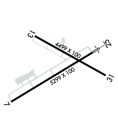
| Rwy | Rwy | |||||||
| 5300x100 | 5300' | 5300x100 | 5300' | 109.70 - 248° | ||||
| 4499x100 | 4499' | 4499x100 | 4499' | |||||
| Runway ID | Single Wheel | Double Wheel | Double Tandem Wheel | Dual Double Wheel |
| 07/25 | 57,000 | 95,000 | 125,000 | N/A |
| 13/31 | 31,000 | 56,000 | N/A | N/A |
| These numbers are Advisory and are not limits. The Airport Manager should have more accurate Weight Limits | ||||
 Airport Diagram might not be current. | |
| Facility Name: | CHAUTAUQUA COUNTY/JAMESTOWN |
| City Name: | JAMESTOWN |
| County: | CHAUTAUQUA |
| State abbrev: | NY |
| State Name: | NEW YORK |
| Ownership: | PUBLICLY OWNED |
| Use: | OPEN TO THE PUBLIC |
| Owner's Name: | CHAUTAUQUA COUNTY |
| Address: | NORTH ERIE ST., COUNTY OFFICE BLDGS |
| MAYVILLE, NY 14757 | |
| Owner's Phone: | 716-753-4800 |
| Manager's Name: | JOHN MACHEMER |
| Address: | 3163 AIRPORT DR |
| JAMESTOWN, NY 14701 | |
| Phone: | 716-581-0062 |
| FAA Region: | EASTERN |
| FAA Field Office: | NYC |
| Date | Sunrise | Sunset |
|---|---|---|
| 06/08/26 Monday | 5:41 | 20:51 |
| 06/09/26 Tuesday | 5:41 | 20:52 |
| 06/10/26 Wednesday | 5:41 | 20:52 |
| 06/11/26 Thursday | 5:40 | 20:53 |
| 06/12/26 Friday | 5:40 | 20:53 |
| 06/13/26 Saturday | 5:40 | 20:54 |
| 06/14/26 Sunday | 5:40 | 20:54 |
| 06/15/26 Monday | 5:40 | 20:55 |
| 06/16/26 Tuesday | 5:40 | 20:55 |
| 06/17/26 Wednesday | 5:40 | 20:56 |
| 06/18/26 Thursday | 5:40 | 20:56 |
| 06/19/26 Friday | 5:41 | 20:56 |
| 06/20/26 Saturday | 5:41 | 20:56 |
| 06/21/26 Sunday | 5:41 | 20:57 |
| Airport Attendance Schedule | M-F 0600-1430 LCL |
| Airport Status | OPERATIONAL (This Status can change at any time - please check NOTAMS) |
| Airport Lighting Schedule | ACTVT MALSR RWY 25; REIL RWY 31; PAPI RWY 13 & 31; VASI RWY 07; HIRL RWY 07/25; MIRL RWY 13/31 & TWY LGTS - CTAF. |
| Airport Storage Available | Tie Downs, Hanger |
| Extra Services Available | Air Freight, Flight Instruction, Aircraft Rental, Aircraft Sales |
| Wind Indicator | YES - (lighted) |
| Control Tower | NO |
| CTAF Frequency | 122.975 |
| Unicom Frequency | 122.975 |
| Rotating Beacon Color | WG |
| Segmented Circle | YES |
| Landing Fee | YES; LNDG FEE MULTI-ENGINE ACFT ONLY. |
| Airport Inspected | 5010-1 PUBLIC USE MAILOUT PROGRAM - performed by FAA AIRPORTS FIELD PERSONNEL |
| Inspection Date | 07/01/2025 |
| Type of Fuel Available | Grade 100LL, JET A (freeze point -40C) |
| Airframe Repair Service | MAJOR |
| Power Plant Repair Service | MAJOR |
| Latitude | N4209.2 |
| Longitude | W07915.5 (ESTIMATED) |
| Arpt Elevation | 1723ft (SURVEYED) |
| Magnetic Variation | 10W |
| 3 miles N | of JAMESTOWN |
| Traffic Pattern Altitude | |
| Sectional Chart | DETROIT |
| Operations (Reported) | Yearly | Avg. Daily |
|---|---|---|
| General Aviation Transient | 0 | 0 |
| General Aviation Local | 0 | 0 |
| Air Taxi | 0 | 0 |
| Commerical | 0 | 0 |
| Commuter | 0 | 0 |
| Military | 0 | 0 |
| Aircraft based on Field | |
|---|---|
| General Aviation Singles | 0 |
| General Aviation Multi | 0 |
| Jet Aircraft | 0 |
| General Aviation Helicopters | 0 |
| Military Aircraft | 0 |
| Gliders | 0 |
| Ultralights | 0 |
| FSS on field | NO |
| FSS tie-in | BUFFALO |
| FSS Phone | 1-800-WX-BRIEF |
| Who issues Notams | JHW |
| Notam D service at airport | YES |
| ARTCC Name | CLEVELAND |
| Airport Certification | AIRPORT RECEIVING SCHEDULED AIR CARRIER SERVICE FROM CARRIERS CERTIFICATED BY THE CIVIL AERONAUTICS BOARD |
| Aircraft Rescue & Firefighting Index | AIRPORT HAS A CERTIFICATE UNDER CFR PART 139 |
| Airport of Entry | No |
| Custom Landing Rights | No |
| Joint Civil/Military | No |
| Military Landing rights | YES |
| NATIONAL PLAN OF INTEGRATED AIRPORT SYSTEMS (NPIAS) |
| GRANT AGREEMENTS UNDER FAAP/ADAP/AIP |
| SURPLUS PROPERTY AGREEMENT UNDER PUBLIC LAW 289 |
| ASSURANCES PURSUANT TO TITLE VI, CIVIL RIGHTS ACT OF 1964 |
| DEER AND BIRDS ON & INVOF ARPT. |
| SNOW REMOVAL OPS AVBL DURING NORMAL ATTENDANCE HRS; SNOW REMOVAL MAY BE LIMITED ON HOLIDAYS & WEEKENDS. |
| FOR CD CTC BUFFALO APCH AT 716-626-6920, WHEN APCH CLSD CTC CLEVELAND ARTCC AT 440-774-0232. |
| ATTENDANCE HRS AND SERVICES AVAILABLE ARE SUBJECT TO CHANGE, CALL AIRPORT MANAGER AT 716-484-0204 TO CONFIRM. |
| RWY/TWY CONDITIONS NOT MONITORED OUTSIDE OF NORMAL ATTENDANCE HRS. |
| 24 HR PPR FOR AIR CARRIER OPS WITH MORE THAN 9 PAX SEATS. CONTACT ARPT MGR AT 716-484-0204. FOR EMERGENCIES AFTER HRS, CALL 911 FOR MUTUAL AID SERVICE. |
| ARFF INDEX B CPBL. |
| RWY 07/2 5 PCR VALUE: 250/F/B/W/T |
| RWY 13/3 1 PCR VALUE: 148/F/C/W/T |
Airport Communications & Frequencies:
| |||||||||||||
| Runway: 07 | Runway: 25 | ||
| Mag heading: | 69° | Mag heading: | 249° |
| Rwy Slope: | -.04% Down | Rwy Slope: | .04% Up |
| Approach: | Approach: | ILS/DME | |
| Pattern: | Left Traffic | Pattern: | Left Traffic |
| Markings: | NONPRECISION INSTRUMENT | Markings: | PRECISION INSTRUMENT |
| Marking Condition: | GOOD | Marking Condition: | GOOD |
| Arresting Dev: | Arresting Dev: | ||
| Lat & Long: | N4208.9 W07916.1 | Lat. & Long.: | N4209.3 W07915.1 |
| Elev: | 1720.6 ft. MSL | Elev: | 1718.6 ft. MSL |
| TCH: | 52 ft. AGL | TCH: | |
| Visual Glide Path: | 3.00 degrees | Visual Glide Path: | |
| Displaced Threshold: | No | Displaced Threshold: | No |
| Touchdown Zone: | YES | Touchdown Zone: | YES |
| Touchdown Elev.: | 1721.6 feet | Touchdown Elev.: | 1721.2 feet |
| Visual Glide Slope: | 4-BOX VASI ON LEFT SIDE OF RUNWAY | Visual Glide Slope: | |
| RVR Equipment: | RVR Equipment: | ||
| RVV Equipment: | NO | RVV Equipment: | NO |
| Approach Lights: | Approach Lights: | MALSR - 1,400 foot medium intensity approach lighting system with runway alignment indicator lights | |
| REIL: | NO | REIL: | NO |
| Centerline Lights: | NO | Centerline Lights: | NO |
| Touchdown lights: | NO | Touchdown lights: | NO |
| Runway Category: | Runway with a Non-precision Approach having visibility minimums greater than 3/4 mile | Runway Category: | Precision Instrument Runway |
| Declared Distances: | TORA:5300' TODA:5300' ASDA:5300' LDA:5300' | Declared Distances: | TORA:5300' TODA:5300' ASDA:5300' LDA:5300' |
| Runway: 13 | Runway: 31 | ||
| Mag heading: | 129° | Mag heading: | 309° |
| Rwy Slope: | -.36% Down | Rwy Slope: | .36% Up |
| Approach: | Approach: | ||
| Pattern: | Left Traffic | Pattern: | Left Traffic |
| Markings: | NONPRECISION INSTRUMENT | Markings: | NONPRECISION INSTRUMENT |
| Marking Condition: | GOOD | Marking Condition: | GOOD |
| Arresting Dev: | Arresting Dev: | ||
| Lat & Long: | N4209.5 W07915.8 | Lat. & Long.: | N4209.1 W07914.9 |
| Elev: | 1723.3 ft. MSL | Elev: | 1707.2 ft. MSL |
| TCH: | 45 ft. AGL | TCH: | 51 ft. AGL |
| Visual Glide Path: | 3.00 degrees | Visual Glide Path: | 3.00 degrees |
| Displaced Threshold: | No | Displaced Threshold: | No |
| Touchdown Zone: | YES | Touchdown Zone: | YES |
| Touchdown Elev.: | 1723.3 feet | Touchdown Elev.: | 1715.2 feet |
| Visual Glide Slope: | 4-Light PAPI on LEFT side of Runway | Visual Glide Slope: | 4-Light PAPI on LEFT side of Runway |
| RVR Equipment: | RVR Equipment: | ||
| RVV Equipment: | NO | RVV Equipment: | NO |
| Approach Lights: | Approach Lights: | ||
| REIL: | NO | REIL: | YES |
| Centerline Lights: | NO | Centerline Lights: | NO |
| Touchdown lights: | NO | Touchdown lights: | NO |
| Runway Category: | Runway with a Non-precision Approach having visibility minimums greater than 3/4 mile | Runway Category: | Runway with a Non-precision Approach having visibility minimums greater than 3/4 mile |
| Declared Distances: | TORA:4499' TODA:4499' ASDA:4499' LDA:4499' | Declared Distances: | TORA:4499' TODA:4499' ASDA:4499' LDA:4499' |
| Obstructions: | TREE | Obstructions: | BLDG |
| Marked: | NOT Marked/Lighted | Marked: | MARKED and LIGHTED |
| Clearance slope: | 17:1 | Clearance slope: | 16:1 |
| Obstruction height: | 69 feet AGL | Obstruction height: | 61 feet AGL |
| Dist. from runway: | 1400 feet | Dist. from runway: | 1200 feet |
| Centerline offset: | 240 left of centerline | Centerline offset: | 300 feet left of centerline |
| Comments: | Comments: |
Thanks for using FltPlan.com
all rights reserved © 1999-2026 by Flight Plan LLC
