
| SANTA YNEZ SANTA YNEZ CA |
| |
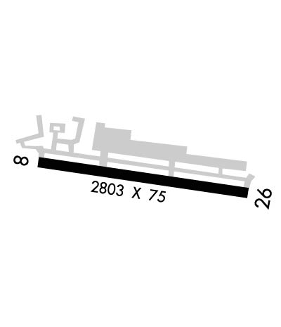
| Lat: N 3436.4 Long: W 12004.5 Elev: 674 Var: -14 Longest Runway: 2803 | ||
| AWOS: 118.07 CTAF: 122.8 | ||
| ||||||||||||||||||||||||||||||||||||||||||||
| ||||||||||||||||||||||||||||||||||||||||||||
| ||||||||||||||||||||||||||||||||||||||||||||
| Rwy | Rwy | |||||||
| 2803x75 | 2803' | 2803x75 | 2803' | |||||
| Runway ID | Single Wheel | Double Wheel | Double Tandem Wheel | Dual Double Wheel |
| 08/26 | 12,500 | N/A | N/A | N/A |
| These numbers are Advisory and are not limits. The Airport Manager should have more accurate Weight Limits | ||||
 Airport Diagram might not be current. | |
| Facility Name: | SANTA YNEZ/KUNKLE FLD |
| City Name: | SANTA YNEZ |
| County: | SANTA BARBARA |
| State abbrev: | CA |
| State Name: | CALIFORNIA |
| Ownership: | PUBLICLY OWNED |
| Use: | OPEN TO THE PUBLIC |
| Owner's Name: | COUNTY OF SANTA BARBARA |
| Address: | 123 EAST ANAPAMU, P.O. BOX 91610 |
| SANTA BARBARA, CA 93190-1610 | |
| Owner's Phone: | 805-568-3037 |
| Manager's Name: | DAVE ROMERO |
| Address: | 900 AIRPORT ROAD, P.O. BOX 1572 |
| SANTA YNEZ, CA 93460 | |
| Phone: | 805-688-8390 |
| FAA Region: | WESTERN-PACIFIC |
| FAA Field Office: | LAX |

| Date | Sunrise | Sunset |
|---|---|---|
| 06/08/26 Monday | 5:47 | 20:12 |
| 06/09/26 Tuesday | 5:47 | 20:12 |
| 06/10/26 Wednesday | 5:47 | 20:13 |
| 06/11/26 Thursday | 5:47 | 20:13 |
| 06/12/26 Friday | 5:47 | 20:14 |
| 06/13/26 Saturday | 5:47 | 20:14 |
| 06/14/26 Sunday | 5:47 | 20:14 |
| 06/15/26 Monday | 5:47 | 20:15 |
| 06/16/26 Tuesday | 5:47 | 20:15 |
| 06/17/26 Wednesday | 5:47 | 20:15 |
| 06/18/26 Thursday | 5:47 | 20:16 |
| 06/19/26 Friday | 5:47 | 20:16 |
| 06/20/26 Saturday | 5:48 | 20:16 |
| 06/21/26 Sunday | 5:48 | 20:16 |
| Airport Attendance Schedule | 7 Days A Week 0700-1900 |
| Airport Status | OPERATIONAL (This Status can change at any time - please check NOTAMS) |
| Airport Lighting Schedule | MIRL RWY 08/26 PRESET LOW INTST; TO INCR INTST & ACTVT REIL RWY 08 & 26; TWY LGTS - CTAF. PAPI RWY 08 & 26 OPR CONSLY. |
| Airport Storage Available | Tie Downs |
| Extra Services Available | Charter, Glider, Flight Instruction, Aircraft Rental, Glider Towing |
| Wind Indicator | YES - (lighted) |
| Control Tower | NO |
| CTAF Frequency | 122.800 |
| Unicom Frequency | 122.800 |
| Rotating Beacon Color | WG |
| Segmented Circle | YES |
| Landing Fee | NO |
| Airport Inspected | STATE - performed by STATE AERONAUTICAL PERSONNEL |
| Inspection Date | 12/08/2025 |
| Type of Fuel Available | Grade 100LL, JET A (freeze point -40C); -10FUEL AVBL 24 HRS USING AUTOMATED SYSTEM. |
| Airframe Repair Service | NONE |
| Power Plant Repair Service | NONE |
| Latitude | N3436.4 |
| Longitude | W12004.5 (ESTIMATED) |
| Arpt Elevation | 674ft (SURVEYED) |
| Magnetic Variation | 14E |
| 1 miles SE | of SANTA YNEZ |
| Traffic Pattern Altitude | |
| Sectional Chart | LOS ANGELES |
| Operations (Reported) | Yearly | Avg. Daily |
|---|---|---|
| General Aviation Transient | 0 | 0 |
| General Aviation Local | 0 | 0 |
| Air Taxi | 0 | 0 |
| Commerical | 0 | 0 |
| Commuter | 0 | 0 |
| Military | 0 | 0 |
| Aircraft based on Field | |
|---|---|
| General Aviation Singles | 0 |
| General Aviation Multi | 0 |
| Jet Aircraft | 0 |
| General Aviation Helicopters | 0 |
| Military Aircraft | 0 |
| Gliders | 0 |
| Ultralights | 0 |
| FSS on field | NO |
| FSS tie-in | HAWTHORNE |
| FSS Phone | 1-800-WX-BRIEF |
| Who issues Notams | IZA |
| Notam D service at airport | YES |
| ARTCC Name | LOS ANGELES |
| Airport Certification | |
| Aircraft Rescue & Firefighting Index | None |
| Airport of Entry | No |
| Custom Landing Rights | No |
| Joint Civil/Military | No |
| Military Landing rights | YES |
| NATIONAL PLAN OF INTEGRATED AIRPORT SYSTEMS (NPIAS) |
| GRANT AGREEMENTS UNDER FAAP/ADAP/AIP |
| ASSURANCES PURSUANT TO TITLE VI, CIVIL RIGHTS ACT OF 1964 |
| RWY 26 TKOF RCMD HDG 210 DEG AT ARPT PERIMETER IF SAFETY PMT FOR NOISE ABATEMENT. |
| GLIDER OPNS ON DIRT APCH ZONE RWY 26; GLIDERS OPERG RIGHT TFC RWY 26. |
| ULTRALIGHT OPNS SOUTH OF RWY 08/26. |
| HELICOPTERS APCH FROM NORTH & SOUTH ON EAST END OF ARPT |
| FOR CD CTC LOS ANGELES ARTCC AT 661-575-2079. |
Airport Communications & Frequencies:
| |||||||||||||||||
| Runway: 08 | Runway: 26 | ||
| Mag heading: | 84° | Mag heading: | 264° |
| Rwy Slope: | .69% Up | Rwy Slope: | -.69% Down |
| Approach: | Approach: | ||
| Pattern: | Right Traffic | Pattern: | Left Traffic |
| Markings: | NONPRECISION INSTRUMENT | Markings: | BASIC |
| Marking Condition: | GOOD | Marking Condition: | FAIR |
| Arresting Dev: | Arresting Dev: | ||
| Lat & Long: | N3436.4 W12004.8 | Lat. & Long.: | N3436.4 W12004.3 |
| Elev: | 655.0 ft. MSL | Elev: | 674.3 ft. MSL |
| TCH: | 31 ft. AGL | TCH: | 22 ft. AGL |
| Visual Glide Path: | 3.00 degrees | Visual Glide Path: | 3.00 degrees |
| Displaced Threshold: | No | Displaced Threshold: | No |
| Touchdown Zone: | YES | Touchdown Zone: | YES |
| Touchdown Elev.: | 674.3 feet | Touchdown Elev.: | 674.3 feet |
| Visual Glide Slope: | 2-Light PAPI on LEFT side of Runway | Visual Glide Slope: | 2-Light PAPI on LEFT side of Runway |
| RVR Equipment: | RVR Equipment: | ||
| RVV Equipment: | NO | RVV Equipment: | NO |
| Approach Lights: | Approach Lights: | ||
| REIL: | YES | REIL: | YES |
| Centerline Lights: | NO | Centerline Lights: | NO |
| Touchdown lights: | NO | Touchdown lights: | NO |
| Runway Category: | Runway with a Non-precision Approach | Runway Category: | Runway with a Visual Approach |
| Declared Distances: | Declared Distances: | ||
| Obstructions: | HILL | Obstructions: | |
| Marked: | NOT Marked/Lighted | Marked: | |
| Clearance slope: | 32:1 | Clearance slope: | 50:1 |
| Obstruction height: | 17 feet AGL | Obstruction height: | |
| Dist. from runway: | 750 feet | Dist. from runway: | |
| Centerline offset: | 150 left of centerline | Centerline offset: | |
| Comments: | Comments: |
Thanks for using FltPlan.com
all rights reserved © 1999-2026 by Flight Plan LLC