
| INYOKERN INYOKERN CA |
| |
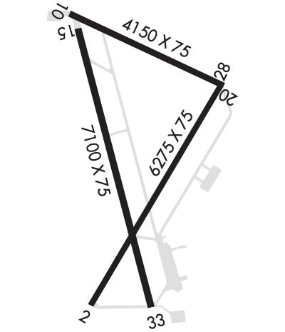
| Lat: N 3539.5 Long: W 11749.8 Elev: 2457 Var: -14 Longest Runway: 7100 | ||
| CTAF: 122.8 | ||
| ||||||
|
| Rwy | Rwy | |||||||
| 6275x75 | 6275' | 6275x75 | 5955' | |||||
| 4150x75 | 4150' | 4150x75 | 4047' | |||||
| 7100x75 | 7100' | 7100x75 | 7100' | |||||
| Runway ID | Single Wheel | Double Wheel | Double Tandem Wheel | Dual Double Wheel |
| 02/20 | 30,000 | 50,000 | 80,000 | N/A |
| 10/28 | 24,000 | N/A | N/A | N/A |
| 15/33 | 24,000 | N/A | N/A | N/A |
| These numbers are Advisory and are not limits. The Airport Manager should have more accurate Weight Limits | ||||
 Airport Diagram might not be current. | |
| Facility Name: | INYOKERN |
| City Name: | INYOKERN |
| County: | KERN |
| State abbrev: | CA |
| State Name: | CALIFORNIA |
| Ownership: | PUBLICLY OWNED |
| Use: | OPEN TO THE PUBLIC |
| Owner's Name: | INDIAN WELLS VALLEY APT DIST |
| Address: | P.O. BOX 634 |
| INYOKERN, CA 93527 | |
| Owner's Phone: | 760-377-5844 |
| Manager's Name: | SCOTT A. SEYMOUR; AIRPORT DIRECTOR. EMAIL: SCOTT@INYOKERNAIRPORT.COM |
| Address: | 1669 AIRPORT ROAD |
| INYOKERN, CA 93527 | |
| Phone: | 760-377-5844 |
| FAA Region: | WESTERN-PACIFIC |
| FAA Field Office: | LAX |
| Date | Sunrise | Sunset |
|---|---|---|
| 09/24/21 Friday | 6:41 | 18:45 |
| 09/25/21 Saturday | 6:41 | 18:44 |
| 09/26/21 Sunday | 6:42 | 18:42 |
| 09/27/21 Monday | 6:43 | 18:41 |
| 09/28/21 Tuesday | 6:44 | 18:40 |
| 09/29/21 Wednesday | 6:45 | 18:38 |
| 09/30/21 Thursday | 6:45 | 18:37 |
| 10/01/21 Friday | 6:46 | 18:35 |
| 10/02/21 Saturday | 6:47 | 18:34 |
| 10/03/21 Sunday | 6:48 | 18:32 |
| 10/04/21 Monday | 6:49 | 18:31 |
| 10/05/21 Tuesday | 6:49 | 18:30 |
| 10/06/21 Wednesday | 6:50 | 18:28 |
| 10/07/21 Thursday | 6:51 | 18:27 |
| Airport Attendance Schedule | MON-FRI 0700-1700 |
| Airport Status | OPERATIONAL (This Status can change at any time - please check NOTAMS) |
| Airport Lighting Schedule | ACTVT VASI RWY 20; MIRL RWYS 02/20, 10/28, 15/33 - CTAF. PAPI RWYS 02, 15 & 33 OPR CONSLY. |
| Airport Storage Available | Tie Downs, Hanger |
| Extra Services Available | Air Freight, Glider, Flight Instruction, Glider Towing |
| Wind Indicator | YES - (lighted) |
| Control Tower | NO |
| CTAF Frequency | 122.800 |
| Unicom Frequency | 122.800; AUTOMATED UNICOM - 3 CLICKS FOR ARPT ADVISORY & WEATHER OR DIAL 617-262-3825, 4 CLICKS FOR RADIO CHECK. |
| Rotating Beacon Color | CLEAR-GREEN (Light Land Airport) |
| Segmented Circle | YES |
| Landing Fee | NO |
| Airport Inspected | FEDERAL - performed by STATE AERONAUTICAL PERSONNEL |
| Inspection Date | 03/22/2021 |
| Type of Fuel Available | Grade 100LL, JET A (freeze point -40C); -10AFTER 1600 CALLOUT FEE FOR SVC CALL (760) 382-3383. |
| Airframe Repair Service | MINOR |
| Power Plant Repair Service | MINOR |
| Latitude | N3539.5 |
| Longitude | W11749.8 (ESTIMATED) |
| Arpt Elevation | 2457ft (SURVEYED) |
| Magnetic Variation | 14E |
| 1 miles NW | of INYOKERN |
| Traffic Pattern Altitude | |
| Sectional Chart | LOS ANGELES |
| Operations (Reported) | Yearly | Avg. Daily |
|---|---|---|
| General Aviation Transient | 6700 | 18 |
| General Aviation Local | 20000 | 55 |
| Air Taxi | 1650 | 5 |
| Commerical | 1374 | 4 |
| Commuter | 0 | 0 |
| Military | 3000 | 8 |
| Aircraft based on Field | |
|---|---|
| General Aviation Singles | 24 |
| General Aviation Multi | 5 |
| Jet Aircraft | 0 |
| General Aviation Helicopters | 0 |
| Military Aircraft | 0 |
| Gliders | 0 |
| Ultralights | 0 |
| FSS on field | NO |
| FSS tie-in | RIVERSIDE |
| FSS Phone | 1-800-WX-BRIEF |
| Who issues Notams | IYK |
| Notam D service at airport | YES |
| ARTCC Name | LOS ANGELES |
| Airport Certification | |
| Aircraft Rescue & Firefighting Index | None |
| Airport of Entry | No |
| Custom Landing Rights | No |
| Joint Civil/Military | No |
| Military Landing rights | No |
| NATIONAL PLAN OF INTEGRATED AIRPORT SYSTEMS (NPIAS) |
| GRANT AGREEMENTS UNDER FAAP/ADAP/AIP |
| SURPLUS PROPERTY AGREEMENT UNDER PUBLIC LAW 289 |
| ASSURANCES PURSUANT TO TITLE VI, CIVIL RIGHTS ACT OF 1964 |
| AGREEMENT UNDER DLAND OR DCLA HAS EXPIRED. |
| THIS AIRPORT HAS BEEN SURVEYED BY THE NATIONAL GEODETIC SURVEY. |
| RY 02/20 & 15/33 HAVE DSTC RMNG SIGNS. |
| FREQUENT GLIDER OPNS ON WEEKENDS. |
| FOR CD CTC LOS ANGELES ARTCC AT 661-575-2079. |
| RWY 10/2 8 CHUNKS OF PAVEMENT ERODED AT RWY 28 THLD. NMRS LRG CRACKS ON RWY. |
Airport Communications & Frequencies:
| ||||||||||||||
| Runway: 02 | Runway: 20 | ||
| Mag heading: | 17° | Mag heading: | 197° |
| Rwy Slope: | -.44% Down | Rwy Slope: | .44% Up |
| Approach: | Approach: | ||
| Pattern: | Left Traffic | Pattern: | Right Traffic |
| Markings: | NONPRECISION INSTRUMENT | Markings: | NONPRECISION INSTRUMENT |
| Marking Condition: | GOOD | Marking Condition: | GOOD |
| Arresting Dev: | Arresting Dev: | ||
| Lat & Long: | N3538.9 W11750.0 | Lat. & Long.: | N3539.8 W11749.4 |
| Elev: | 2441.6 ft. MSL | Elev: | 2413.7 ft. MSL |
| TCH: | 40 ft. AGL | TCH: | 35 ft. AGL |
| Visual Glide Path: | 3.30 degrees | Visual Glide Path: | 3.00 degrees |
| Displaced Threshold: | No | Displaced Threshold: | 320 feet |
| Touchdown Zone: | YES | Touchdown Zone: | YES |
| Touchdown Elev.: | 2442.0 feet | Touchdown Elev.: | 2430.0 feet |
| Visual Glide Slope: | 2-Light PAPI on LEFT side of Runway | Visual Glide Slope: | 4-BOX VASI ON LEFT SIDE OF RUNWAY |
| RVR Equipment: | RVR Equipment: | ||
| RVV Equipment: | NO | RVV Equipment: | NO |
| Approach Lights: | Approach Lights: | ||
| REIL: | NO | REIL: | NO |
| Centerline Lights: | NO | Centerline Lights: | NO |
| Touchdown lights: | NO | Touchdown lights: | NO |
| Runway Category: | Runway with a Non-precision Approach having visibility minimums greater than 3/4 mile | Runway Category: | Runway with a Visual Approach |
| Declared Distances: | Declared Distances: |
| Runway: 10 | Runway: 28 | ||
| Mag heading: | 101° | Mag heading: | 281° |
| Rwy Slope: | -1.05% Down | Rwy Slope: | 1.05% Up |
| Approach: | Approach: | ||
| Pattern: | Left Traffic | Pattern: | Left Traffic |
| Markings: | NUMBERS ONLY | Markings: | NUMBERS ONLY |
| Marking Condition: | FAIR | Marking Condition: | FAIR |
| Arresting Dev: | Arresting Dev: | ||
| Lat & Long: | N3540.1 W11750.1 | Lat. & Long.: | N3539.8 W11749.3 |
| Elev: | 2456.7 ft. MSL | Elev: | 2413.3 ft. MSL |
| TCH: | TCH: | ||
| Visual Glide Path: | Visual Glide Path: | ||
| Displaced Threshold: | No | Displaced Threshold: | 103 feet |
| Touchdown Zone: | YES | Touchdown Zone: | YES |
| Touchdown Elev.: | 2457.0 feet | Touchdown Elev.: | 2447.0 feet |
| Visual Glide Slope: | Visual Glide Slope: | ||
| RVR Equipment: | RVR Equipment: | ||
| RVV Equipment: | NO | RVV Equipment: | NO |
| Approach Lights: | Approach Lights: | ||
| REIL: | NO | REIL: | NO |
| Centerline Lights: | NO | Centerline Lights: | NO |
| Touchdown lights: | NO | Touchdown lights: | NO |
| Runway Category: | Runway with a Visual Approach | Runway Category: | Runway with a Visual Approach |
| Declared Distances: | Declared Distances: |
| Runway: 15 | Runway: 33 | ||
| Mag heading: | 152° | Mag heading: | 332° |
| Rwy Slope: | -.37% Down | Rwy Slope: | .37% Up |
| Approach: | Approach: | ||
| Pattern: | Left Traffic | Pattern: | Left Traffic |
| Markings: | BASIC | Markings: | BASIC |
| Marking Condition: | GOOD | Marking Condition: | GOOD |
| Arresting Dev: | Arresting Dev: | ||
| Lat & Long: | N3540.0 W11750.1 | Lat. & Long.: | N3538.9 W11749.7 |
| Elev: | 2454.9 ft. MSL | Elev: | 2428.8 ft. MSL |
| TCH: | 40 ft. AGL | TCH: | 40 ft. AGL |
| Visual Glide Path: | 3.00 degrees | Visual Glide Path: | 3.30 degrees |
| Displaced Threshold: | No | Displaced Threshold: | No |
| Touchdown Zone: | YES | Touchdown Zone: | YES |
| Touchdown Elev.: | 2455.0 feet | Touchdown Elev.: | 2446.0 feet |
| Visual Glide Slope: | 2-Light PAPI on LEFT side of Runway | Visual Glide Slope: | 2-Light PAPI on LEFT side of Runway |
| RVR Equipment: | RVR Equipment: | ||
| RVV Equipment: | NO | RVV Equipment: | NO |
| Approach Lights: | Approach Lights: | ||
| REIL: | NO | REIL: | NO |
| Centerline Lights: | NO | Centerline Lights: | NO |
| Touchdown lights: | NO | Touchdown lights: | NO |
| Runway Category: | Runway with a Visual Approach | Runway Category: | Runway with a Visual Approach |
| Declared Distances: | Declared Distances: |
Thanks for using FltPlan.com
all rights reserved © 1999-2021 by Flight Plan LLC
