
| WABASH MUNI WABASH IN |
| |
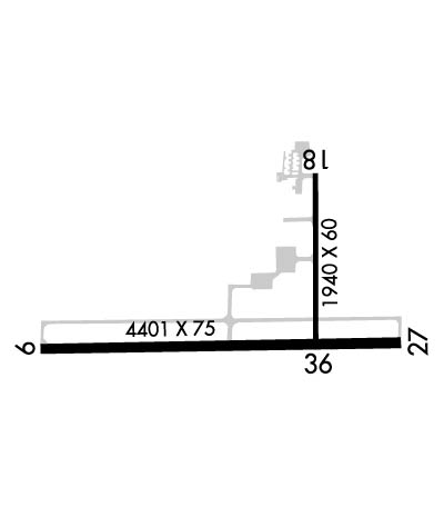
| Lat: N 4045.7 Long: W 08547.9 Elev: 796 Var: +03 Longest Runway: 4401 | ||
| CTAF: 122.8 | ||
| ||||||||||||||||||||||||||||||||||||||||||||
| ||||||||||||||||||||||||||||||||||||||||||||
| Rwy | Rwy | |||||||
| 4401x75 | 4401' | 4401x75 | 4401' | |||||
| 1940x60 | 1537' | 1940x60 | 1940' | |||||
| Runway ID | Single Wheel | Double Wheel | Double Tandem Wheel | Dual Double Wheel |
| 09/27 | 27,000 | N/A | N/A | N/A |
| 18/36 | 27,000 | N/A | N/A | N/A |
| These numbers are Advisory and are not limits. The Airport Manager should have more accurate Weight Limits | ||||
 Airport Diagram might not be current. | |
| Facility Name: | WABASH MUNI |
| City Name: | WABASH |
| County: | WABASH |
| State abbrev: | IN |
| State Name: | INDIANA |
| Ownership: | PUBLICLY OWNED |
| Use: | OPEN TO THE PUBLIC |
| Owner's Name: | WABASH BOAC |
| Address: | 283 W. 400 S. |
| WABASH, IN 46992 | |
| Owner's Phone: | 260-563-4705 |
| Manager's Name: | JOHN DERBY |
| Address: | 283 W. 400 S. |
| WABASH, IN 46992 | |
| Phone: | 260-563-4705; 260-571-2039 |
| FAA Region: | GREAT LAKES |
| FAA Field Office: | CHI |
| Date | Sunrise | Sunset |
|---|---|---|
| 09/24/21 Friday | 7:32 | 19:37 |
| 09/25/21 Saturday | 7:33 | 19:36 |
| 09/26/21 Sunday | 7:34 | 19:34 |
| 09/27/21 Monday | 7:35 | 19:32 |
| 09/28/21 Tuesday | 7:36 | 19:31 |
| 09/29/21 Wednesday | 7:37 | 19:29 |
| 09/30/21 Thursday | 7:38 | 19:27 |
| 10/01/21 Friday | 7:39 | 19:26 |
| 10/02/21 Saturday | 7:40 | 19:24 |
| 10/03/21 Sunday | 7:42 | 19:22 |
| 10/04/21 Monday | 7:43 | 19:21 |
| 10/05/21 Tuesday | 7:44 | 19:19 |
| 10/06/21 Wednesday | 7:45 | 19:17 |
| 10/07/21 Thursday | 7:46 | 19:16 |
| Airport Attendance Schedule | MAY - OCT SUN 1230 - 1730, NOV - APR SUN 1230 - 1700, MAY-OCT MON - SAT 0800-1800, NOV-APR MON - SAT 0800-1700 |
| Airport Status | OPERATIONAL (This Status can change at any time - please check NOTAMS) |
| Airport Lighting Schedule | ACTVT REIL RWY 09 & 27 - CTAF. MIRL RWY 09/27 PRESET LOW INTST; INCR INTST - CTAF. |
| Airport Storage Available | Tie Downs |
| Extra Services Available | Charter, Flight Instruction, Aircraft Rental |
| Wind Indicator | YES - (lighted) |
| Control Tower | NO |
| CTAF Frequency | 122.800 |
| Unicom Frequency | 122.800 |
| Rotating Beacon Color | CLEAR-GREEN (Light Land Airport) |
| Segmented Circle | NO |
| Landing Fee | NO |
| Airport Inspected | STATE - performed by STATE AERONAUTICAL PERSONNEL |
| Inspection Date | 10/09/2019 |
| Type of Fuel Available | Grade 100LL, JET A (freeze point -40C); -1024 HR CREDIT CARD FUELSVC AVBL. |
| Airframe Repair Service | NONE |
| Power Plant Repair Service | NONE |
| Latitude | N4045.7 |
| Longitude | W08547.9 (ESTIMATED) |
| Arpt Elevation | 795ft (SURVEYED) |
| Magnetic Variation | 03W |
| 3 miles SE | of WABASH |
| Traffic Pattern Altitude | |
| Sectional Chart | CHICAGO |
| Operations (Reported) | Yearly | Avg. Daily |
|---|---|---|
| General Aviation Transient | 1306 | 4 |
| General Aviation Local | 3109 | 9 |
| Air Taxi | 90 | 0 |
| Commerical | 0 | 0 |
| Commuter | 0 | 0 |
| Military | 0 | 0 |
| Aircraft based on Field | |
|---|---|
| General Aviation Singles | 10 |
| General Aviation Multi | 1 |
| Jet Aircraft | 0 |
| General Aviation Helicopters | 0 |
| Military Aircraft | 0 |
| Gliders | 0 |
| Ultralights | 0 |
| FSS on field | NO |
| FSS tie-in | TERRE HAUTE |
| FSS Phone | 1-800-WX-BRIEF |
| Who issues Notams | HUF |
| Notam D service at airport | YES |
| ARTCC Name | CHICAGO |
| Airport Certification | |
| Aircraft Rescue & Firefighting Index | None |
| Airport of Entry | No |
| Custom Landing Rights | No |
| Joint Civil/Military | No |
| Military Landing rights | YES |
| NATIONAL PLAN OF INTEGRATED AIRPORT SYSTEMS (NPIAS) |
| GRANT AGREEMENTS UNDER FAAP/ADAP/AIP |
| ASSURANCES PURSUANT TO TITLE VI, CIVIL RIGHTS ACT OF 1964 |
| FOR CD CTC CHICAGO ARTCC AT 630-906-8921. |
Airport Communications & Frequencies:
| |||||||||||||||||
| Runway: 09 | Runway: 27 | ||
| Mag heading: | 92° | Mag heading: | 272° |
| Rwy Slope: | -.04% Down | Rwy Slope: | .04% Up |
| Approach: | Approach: | ||
| Pattern: | Left Traffic; ULTRALIGHT USE R TFC PAT. | Pattern: | Left Traffic |
| Markings: | NONPRECISION INSTRUMENT | Markings: | NONPRECISION INSTRUMENT |
| Marking Condition: | FAIR | Marking Condition: | FAIR |
| Arresting Dev: | Arresting Dev: | ||
| Lat & Long: | N4045.7 W08548.5 | Lat. & Long.: | N4045.7 W08547.5 |
| Elev: | 793.4 ft. MSL | Elev: | 791.7 ft. MSL |
| TCH: | 32 ft. AGL | TCH: | 32 ft. AGL |
| Visual Glide Path: | 3.00 degrees | Visual Glide Path: | 3.00 degrees |
| Displaced Threshold: | No | Displaced Threshold: | No |
| Touchdown Zone: | YES | Touchdown Zone: | YES |
| Touchdown Elev.: | 795.6 feet | Touchdown Elev.: | 795.6 feet |
| Visual Glide Slope: | 2-Light PAPI on LEFT side of Runway | Visual Glide Slope: | 2-Light PAPI on LEFT side of Runway |
| RVR Equipment: | RVR Equipment: | ||
| RVV Equipment: | NO | RVV Equipment: | NO |
| Approach Lights: | Approach Lights: | ||
| REIL: | YES | REIL: | YES |
| Centerline Lights: | NO | Centerline Lights: | NO |
| Touchdown lights: | NO | Touchdown lights: | NO |
| Runway Category: | Runway with a Visual Approach | Runway Category: | Runway with a Non-precision Approach |
| Declared Distances: | Declared Distances: | ||
| Obstructions: | ROAD; +54 FT UNLGTD PLINE 1275 FT FM RWY END; 19:1 OBSTN CLNC SLOPE. | Obstructions: | TREES |
| Marked: | NOT Marked/Lighted | Marked: | NOT Marked/Lighted |
| Clearance slope: | 20:1 | Clearance slope: | 23:1 |
| Obstruction height: | 15 feet AGL | Obstruction height: | 50 feet AGL |
| Dist. from runway: | 500 feet | Dist. from runway: | 1380 feet |
| Centerline offset: | Centerline offset: | ||
| Comments: | Comments: |
| Runway: 18 | Runway: 36 | ||
| Mag heading: | 182° | Mag heading: | 2° |
| Rwy Slope: | .12% Up | Rwy Slope: | -.12% Down |
| Approach: | Approach: | ||
| Pattern: | Left Traffic | Pattern: | Left Traffic |
| Markings: | BASIC | Markings: | BASIC |
| Marking Condition: | FAIR | Marking Condition: | FAIR |
| Arresting Dev: | Arresting Dev: | ||
| Lat & Long: | N4046.0 W08547.8 | Lat. & Long.: | N4045.7 W08547.8 |
| Elev: | 790.4 ft. MSL | Elev: | 792.8 ft. MSL |
| TCH: | TCH: | ||
| Visual Glide Path: | Visual Glide Path: | ||
| Displaced Threshold: | 403 feet | Displaced Threshold: | No |
| Touchdown Zone: | YES | Touchdown Zone: | YES |
| Touchdown Elev.: | 793.6 feet | Touchdown Elev.: | 793.6 feet |
| Visual Glide Slope: | Visual Glide Slope: | ||
| RVR Equipment: | RVR Equipment: | ||
| RVV Equipment: | NO | RVV Equipment: | NO |
| Approach Lights: | Approach Lights: | ||
| REIL: | NO | REIL: | NO |
| Centerline Lights: | NO | Centerline Lights: | NO |
| Touchdown lights: | NO | Touchdown lights: | NO |
| Runway Category: | Runway with a Visual Approach | Runway Category: | Runway with a Visual Approach |
| Declared Distances: | Declared Distances: | ||
| Obstructions: | TREES | Obstructions: | TREES |
| Marked: | NOT Marked/Lighted | Marked: | NOT Marked/Lighted |
| Clearance slope: | 13:1; APCH RATIO 20:1 TO DSPLCD THR. | Clearance slope: | 8:1 |
| Obstruction height: | 84 feet AGL | Obstruction height: | 60 feet AGL |
| Dist. from runway: | 1298 feet | Dist. from runway: | 650 feet |
| Centerline offset: | Centerline offset: | 100 feet right of centerline | |
| Comments: | Comments: |
Thanks for using FltPlan.com
all rights reserved © 1999-2021 by Flight Plan LLC
