| GOGEBIC-IRON COUNTY IRONWOOD MI |
| |
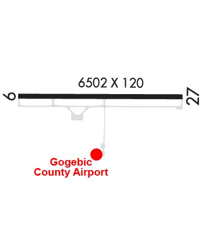
| Lat: N 4631.6 Long: W 09007.9 Elev: 1230 Var: -00 Longest Runway: 6502 | ||
| AWOS: 125.17 CTAF: 122.8 | ||
| |||||||||||||||||||||||
| |||||||||||||||||||||||
| |||||||||||||||||||||||
| Rwy | Rwy | |||||||
| 6502x100 | 6502' | 6502x100 | 6502' | 111.50 - 270° | ||||
| Runway ID | Single Wheel | Double Wheel | Double Tandem Wheel | Dual Double Wheel |
| 09/27 | 85,000 | 150,000 | 280,000 | N/A |
| These numbers are Advisory and are not limits. The Airport Manager should have more accurate Weight Limits | ||||
 Airport Diagram might not be current. | |
| Facility Name: | GOGEBIC-IRON COUNTY |
| City Name: | IRONWOOD |
| County: | GOGEBIC |
| State abbrev: | MI |
| State Name: | MICHIGAN |
| Ownership: | PUBLICLY OWNED |
| Use: | OPEN TO THE PUBLIC |
| Owner's Name: | GOGEBIC COUNTY |
| Address: | GOGEBIC CO COURTHOUSE, 200 N MOORE ST |
| BESSEMER, MI 49911-1052 | |
| Owner's Phone: | 906-932-3121 |
| Manager's Name: | MICHAEL HARMA |
| Address: | E5560 AIRPORT RD |
| IRONWOOD, MI 49938-9202 | |
| Phone: | 906-932-3121 |
| FAA Region: | GREAT LAKES |
| FAA Field Office: | DET |
| Date | Sunrise | Sunset |
|---|---|---|
| 09/24/21 Friday | 6:50 | 18:55 |
| 09/25/21 Saturday | 6:51 | 18:53 |
| 09/26/21 Sunday | 6:52 | 18:51 |
| 09/27/21 Monday | 6:54 | 18:49 |
| 09/28/21 Tuesday | 6:55 | 18:47 |
| 09/29/21 Wednesday | 6:56 | 18:45 |
| 09/30/21 Thursday | 6:57 | 18:43 |
| 10/01/21 Friday | 6:59 | 18:41 |
| 10/02/21 Saturday | 7:00 | 18:39 |
| 10/03/21 Sunday | 7:01 | 18:37 |
| 10/04/21 Monday | 7:03 | 18:35 |
| 10/05/21 Tuesday | 7:04 | 18:33 |
| 10/06/21 Wednesday | 7:05 | 18:31 |
| 10/07/21 Thursday | 7:07 | 18:29 |
| Airport Attendance Schedule | 7 Days A Week 0500-2230 |
| Airport Status | OPERATIONAL (This Status can change at any time - please check NOTAMS) |
| Airport Lighting Schedule | ACTVT MALSR RWY 27; REIL RWY 09; PAPI RWY 09; HIRL RWY 09/27 - CTAF. |
| Airport Storage Available | Tie Downs, Hanger |
| Extra Services Available | NONE |
| Wind Indicator | YES - (lighted) |
| Control Tower | NO |
| CTAF Frequency | 122.800 |
| Unicom Frequency | 122.800 |
| Rotating Beacon Color | CLEAR-GREEN (Light Land Airport) |
| Segmented Circle | YES |
| Landing Fee | YES; WAIVED WITH FUEL PURCHASE. |
| Airport Inspected | FEDERAL - performed by FAA AIRPORTS FIELD PERSONNEL |
| Inspection Date | 06/07/2021 |
| Type of Fuel Available | Grade 100LL, JET A (freeze point -40C) |
| Airframe Repair Service | None |
| Power Plant Repair Service | None |
| Latitude | N4631.6 |
| Longitude | W09007.9 (ESTIMATED) |
| Arpt Elevation | 1230ft (SURVEYED) |
| Magnetic Variation | 00E |
| 7 miles NE | of IRONWOOD |
| Traffic Pattern Altitude | |
| Sectional Chart | GREEN BAY |
| Operations (Reported) | Yearly | Avg. Daily |
|---|---|---|
| General Aviation Transient | 1550 | 4 |
| General Aviation Local | 2000 | 5 |
| Air Taxi | 500 | 1 |
| Commerical | 1706 | 5 |
| Commuter | 0 | 0 |
| Military | 10 | 0 |
| Aircraft based on Field | |
|---|---|
| General Aviation Singles | 16 |
| General Aviation Multi | 3 |
| Jet Aircraft | 0 |
| General Aviation Helicopters | 0 |
| Military Aircraft | 0 |
| Gliders | 0 |
| Ultralights | 0 |
| FSS on field | NO |
| FSS tie-in | GREEN BAY |
| FSS Phone | 1-800-WX-BRIEF |
| Who issues Notams | IWD |
| Notam D service at airport | YES |
| ARTCC Name | MINNEAPOLIS |
| Airport Certification | AIRPORT RECEIVING SCHEDULED AIR CARRIER SERVICE FROM CARRIERS CERTIFICATED BY THE CIVIL AERONAUTICS BOARD; ARPT CLSD TO UNSKED ACR OPS GTR THAN 30 PAX SEATS EXC 48 HR PPR CALL AMGR. |
| Aircraft Rescue & Firefighting Index | AIRPORT HAS A CERTIFICATE UNDER CFR PART 139 |
| Airport of Entry | No |
| Custom Landing Rights | No |
| Joint Civil/Military | No |
| Military Landing rights | YES |
| NATIONAL PLAN OF INTEGRATED AIRPORT SYSTEMS (NPIAS) |
| GRANT AGREEMENTS UNDER FAAP/ADAP/AIP |
| ASSURANCES PURSUANT TO TITLE VI, CIVIL RIGHTS ACT OF 1964 |
| VARIOUS WILDLIFE ON & INVOF ARPT. |
| ARPT SIGNS MAY BE SNOW COVD DRG WINTER MONTHS. |
| BE ALERT FOR PAEW DRG SNOW REMOVAL. |
| ARFF PSNL MNT CTAF DRG ALL SKEDD ACR OPS. |
| ARPT PSNL MNT CTAF DRG ALL SKEDD ACR OPS TO PRVD SFC COND RPRTS DRG WINTER WX. |
| COLD TEMPERATURE RESTRICTED AIRPORT. ALTITUDE CORRECTION REQUIRED AT OR BELOW -27C. |
| SFC CONDS UNMON MON-FRI 2230-0500, SAT 2230-0800, & SUN 2000-0800. |
| FOR CD IF UNA TO CTC ON FSS FREQ, CTC MINNEAPOLIS ARTCC AT 651-463-5588. |
Airport Communications & Frequencies:
| |||||||||
| Runway: 09 | Runway: 27 | ||
| Mag heading: | 90° | Mag heading: | 270° |
| Rwy Slope: | .11% Up | Rwy Slope: | -.11% Down |
| Approach: | Approach: | ILS | |
| Pattern: | Left Traffic | Pattern: | Left Traffic |
| Markings: | PRECISION INSTRUMENT | Markings: | PRECISION INSTRUMENT |
| Marking Condition: | GOOD | Marking Condition: | GOOD |
| Arresting Dev: | Arresting Dev: | ||
| Lat & Long: | N4631.7 W09008.7 | Lat. & Long.: | N4631.6 W09007.1 |
| Elev: | 1222.9 ft. MSL | Elev: | 1230.1 ft. MSL |
| TCH: | 47 ft. AGL | TCH: | |
| Visual Glide Path: | 3.00 degrees | Visual Glide Path: | |
| Displaced Threshold: | No | Displaced Threshold: | No |
| Touchdown Zone: | YES | Touchdown Zone: | YES |
| Touchdown Elev.: | 1229.8 feet | Touchdown Elev.: | 1230.3 feet |
| Visual Glide Slope: | 4-Light PAPI on LEFT side of Runway | Visual Glide Slope: | |
| RVR Equipment: | RVR Equipment: | ||
| RVV Equipment: | NO | RVV Equipment: | NO |
| Approach Lights: | Approach Lights: | MALSR - 1,400 foot medium intensity approach lighting system with runway alignment indicator lights | |
| REIL: | YES | REIL: | NO |
| Centerline Lights: | NO | Centerline Lights: | NO |
| Touchdown lights: | NO | Touchdown lights: | NO |
| Runway Category: | Runway with a Non-precision Approach having visibility minimums greater than 3/4 mile | Runway Category: | Precision Instrument Runway |
| Declared Distances: | TORA:6501' TODA:6501' ASDA:6501' LDA:6501' | Declared Distances: | TORA:6501' TODA:6501' ASDA:6501' LDA:6501' |
| Obstructions: | TREES | Obstructions: | TREES |
| Marked: | NOT Marked/Lighted | Marked: | NOT Marked/Lighted |
| Clearance slope: | 26:1 | Clearance slope: | 42:1 |
| Obstruction height: | 97 feet AGL | Obstruction height: | 104 feet AGL |
| Dist. from runway: | 2817 feet | Dist. from runway: | 4578 feet |
| Centerline offset: | 587 right of centerline | Centerline offset: | 480 feet left of centerline |
| Comments: | Comments: |
Thanks for using FltPlan.com
all rights reserved © 1999-2021 by Flight Plan LLC