
| PHOENIX-MESA GATEWAY PHOENIX AZ |
| |
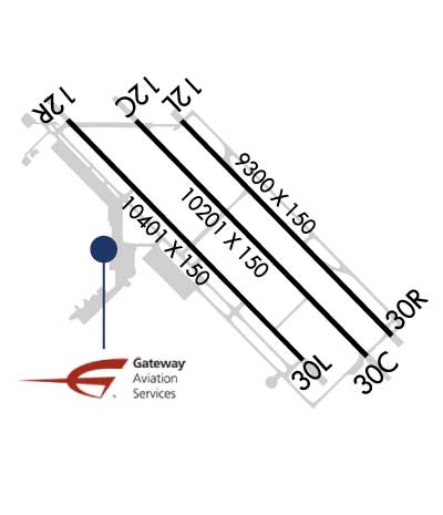
| Lat: N 3318.5 Long: W 11139.3 Elev: 1384 Var: -13 Longest Runway: 10401 | ||
| Clr Del: 135.05 Dept. ATIS: 133.5 Arr. ATIS: 133.5 AWOS: 133.5 Ground: 128.25 Tower: 120.6 | ||
| |||||||||||||||||||||||||||||||||||||||||||||||||||||||||||||||||||||
| |||||||||||||||||||||||||||||||||||||||||||||||||||||||||||||||||||||
| |||||||||||||||||||||||||||||||||||||||||||||||||||||||||||||||||||||
| Rwy | Rwy | |||||||
| 10201x150 | 10201' | 10201x150 | 10201' | 110.15 - 302° | ||||
| 9300x150 | 9300' | 9300x150 | 9300' | |||||
| 10401x150 | 10401' | 10401x150 | 10401' | |||||
| Runway ID | Single Wheel | Double Wheel | Double Tandem Wheel | Dual Double Wheel |
| 12C/30C | 55,000 | 95,000 | 185,000 | 550,000 |
| 12L/30R | 75,000 | 210,000 | 590,000 | 850,000 |
| 12R/30L | 55,000 | 95,000 | 185,000 | 550,000 |
| These numbers are Advisory and are not limits. The Airport Manager should have more accurate Weight Limits | ||||
 Airport Diagram might not be current. | |
| Facility Name: | PHOENIX-MESA GATEWAY |
| City Name: | PHOENIX |
| County: | MARICOPA |
| State abbrev: | AZ |
| State Name: | ARIZONA |
| Ownership: | PUBLICLY OWNED |
| Use: | OPEN TO THE PUBLIC |
| Owner's Name: | PHX MESA GATEWAY AIRPORT AUTHORITY |
| Address: | 5835 S. SOSSAMAN RD |
| MESA, AZ 85212-0919 | |
| Owner's Phone: | (480) 988-7570 |
| Manager's Name: | J. BRIAN O'NEILL |
| Address: | PHX-MESA GATEWAY AIRPORT AUTHORITY, 5835 S. SOSSAMAN ROAD |
| MESA, AZ 85212-0919 | |
| Phone: | (480) 988-7708 |
| FAA Region: | WESTERN-PACIFIC |
| FAA Field Office: | PHX |
| Date | Sunrise | Sunset |
|---|---|---|
| 09/24/21 Friday | 6:16 | 18:21 |
| 09/25/21 Saturday | 6:17 | 18:19 |
| 09/26/21 Sunday | 6:17 | 18:18 |
| 09/27/21 Monday | 6:18 | 18:17 |
| 09/28/21 Tuesday | 6:19 | 18:15 |
| 09/29/21 Wednesday | 6:19 | 18:14 |
| 09/30/21 Thursday | 6:20 | 18:13 |
| 10/01/21 Friday | 6:21 | 18:11 |
| 10/02/21 Saturday | 6:21 | 18:10 |
| 10/03/21 Sunday | 6:22 | 18:09 |
| 10/04/21 Monday | 6:23 | 18:07 |
| 10/05/21 Tuesday | 6:24 | 18:06 |
| 10/06/21 Wednesday | 6:24 | 18:05 |
| 10/07/21 Thursday | 6:25 | 18:03 |
| Airport Attendance Schedule | CONTINUOUS |
| Airport Status | OPERATIONAL (This Status can change at any time - please check NOTAMS) |
| Airport Lighting Schedule | FOR REIL RWY 12L & 30R CTC ATCT. AFTER ATCT CLSD, ARPT LGTS REMAIN ON. |
| Airport Storage Available | Tie Downs, Hanger |
| Extra Services Available | Air Ambulance, Cargo Handling, Charter, Flight Instruction, Aircraft Rental |
| Wind Indicator | YES - (unlit) |
| Control Tower | YES |
| CTAF Frequency | 120.600 |
| Unicom Frequency | |
| Rotating Beacon Color | CLEAR-GREEN (Light Land Airport) |
| Segmented Circle | YES |
| Landing Fee | YES; NO LDG FEE FOR US GOV OWNED, NON-REVENUE AND FLIGHT TRAINING ACFT UP TO 12,500 LBS. |
| Airport Inspected | FEDERAL - performed by FAA AIRPORTS FIELD PERSONNEL |
| Inspection Date | 02/21/2019 |
| Type of Fuel Available | Grade 100LL, JET A (freeze point -40C); -10FUEL AVBL 24 HRS CTC 480-988-7700 OR 129.875. |
| Airframe Repair Service | MINOR |
| Power Plant Repair Service | None |
| Latitude | N3318.5 |
| Longitude | W11139.3 (ESTIMATED) |
| Arpt Elevation | 1384ft (SURVEYED) |
| Magnetic Variation | 13E |
| 20 miles SE | of PHOENIX |
| Traffic Pattern Altitude | 1218; TPA FIXED WING 1218 FT AGL, JET 1718 FT AGL, ROTORCRAFT 718 FT AGL. |
| Sectional Chart | PHOENIX |
| Operations (Reported) | Yearly | Avg. Daily |
|---|---|---|
| General Aviation Transient | 65228 | 179 |
| General Aviation Local | 160307 | 439 |
| Air Taxi | 45324 | 124 |
| Commerical | 12197 | 33 |
| Commuter | 0 | 0 |
| Military | 5865 | 16 |
| Aircraft based on Field | |
|---|---|
| General Aviation Singles | 87 |
| General Aviation Multi | 20 |
| Jet Aircraft | 18 |
| General Aviation Helicopters | 1 |
| Military Aircraft | 0 |
| Gliders | 0 |
| Ultralights | 0 |
| FSS on field | NO |
| FSS tie-in | PRESCOTT |
| FSS Phone | 1-800-WX-BRIEF |
| Who issues Notams | IWA |
| Notam D service at airport | YES |
| ARTCC Name | ALBUQUERQUE |
| Airport Certification | AIRPORT RECEIVING SCHEDULED AIR CARRIER SERVICE FROM CARRIERS CERTIFICATED BY THE CIVIL AERONAUTICS BOARD |
| Aircraft Rescue & Firefighting Index | AIRPORT HAS A CERTIFICATE UNDER CFR PART 139 |
| Airport of Entry | No |
| Custom Landing Rights | No; US CUSTOMS USER FEE ARPT. |
| Joint Civil/Military | No |
| Military Landing rights | YES |
| NATIONAL PLAN OF INTEGRATED AIRPORT SYSTEMS (NPIAS) |
| VOLUNTARY NOISE ABATEMENT PROCEDURES IN EFFECT. AVOID LOW OVERFLIGHT OF NOISE SENSITIVE AREAS SURROUNDING AIRPORT. FOR NOISE ABATEMENT INFO CTC AIRPORT (480) 988-7637. |
| BE ALERT FOR CROP DUSTING ACTIVITY INVOF ARPT. |
| BE ALERT FOR CROP DUSTING ACTIVITY AT OR BELOW 2000 FEET MSL BETWEEN 2 AND 3 MILES ON APCH FOR RWY 30R, RWY 30L AND RWY 30C. |
| TWY W BETWEEN TWY H AND TWY V RSTD TO ACFT WITH WING SPAN LESS THAN 135 FT TWY W BETWEEN TWY T AND TWY V RSTRD TO ACFT WITH WING SPAN LESS THAN 118 FT. |
| TWY Y RSTD TO ACFT WITH WINGSPAN LESS THAN 79 FT. |
| 7 FT CHAIN LINK FENCE ON SOUTHERN PORTION OF MIDDLE RAMP. |
| LARGE/HEAVY ACFT TAXI WITH INBOARD ENGINES ONLY. |
| TWY T ACCESSIBLE FOR ACFT WITH WINGSPAN BETWEEN 119 FT AND 170 FT WITH WING WALKERS FROM TWY W SOUTH OF TWY V. |
| ALL NON-EMERG ACFT OPS OF AV-8 MODEL ACFT, ALL VARIATIONS, LIMITED TO RWY 12L/30R. |
| 24-HR PRIOR PERMISSION REQ FOR UNSCHEDULED AIR CARRIER OPS WITH MORE THAN 30 PASSENGER SEATS, CALL ARPT OPS. |
| FOR CD WHEN ATCT CLSD, CTC PHOENIX APCH AT 602-306-2565. |
| OCNL WILDLIFE INVOF ARPT. |
| RWY 12C/ 30CRWY 12C FIRST 1000 FT CONC, RWY 30C FIRST 3500 FT CONC, REMAINING CENTER PORTION ASPH. |
Airport Communications & Frequencies:
| |||||||||||||||||||||||||||||||||
| Runway: 12C | Runway: 30C | ||
| Mag heading: | 123° | Mag heading: | 303° |
| Rwy Slope: | .32% Up | Rwy Slope: | -.32% Down |
| Approach: | Approach: | LOC/GS | |
| Pattern: | Left Traffic | Pattern: | Left Traffic |
| Markings: | PRECISION INSTRUMENT | Markings: | PRECISION INSTRUMENT |
| Marking Condition: | GOOD | Marking Condition: | GOOD |
| Arresting Dev: | MA-1A | Arresting Dev: | MA-1A |
| Lat & Long: | N3319.1 W11140.0 | Lat. & Long.: | N3317.9 W11138.6 |
| Elev: | 1347.7 ft. MSL | Elev: | 1380.5 ft. MSL |
| TCH: | 50 ft. AGL | TCH: | 49 ft. AGL |
| Visual Glide Path: | 3.00 degrees | Visual Glide Path: | 3.00 degrees |
| Displaced Threshold: | No | Displaced Threshold: | No |
| Touchdown Zone: | YES | Touchdown Zone: | YES |
| Touchdown Elev.: | 1358.5 feet | Touchdown Elev.: | 1380.5 feet |
| Visual Glide Slope: | 4-Light PAPI on LEFT side of Runway | Visual Glide Slope: | 4-Light PAPI on LEFT side of Runway |
| RVR Equipment: | RVR Equipment: | ||
| RVV Equipment: | NO | RVV Equipment: | NO |
| Approach Lights: | Approach Lights: | ||
| REIL: | NO | REIL: | NO |
| Centerline Lights: | NO | Centerline Lights: | NO |
| Touchdown lights: | NO | Touchdown lights: | NO |
| Runway Category: | Runway with a Non-precision Approach having visibility minimums greater than 3/4 mile | Runway Category: | Precision Instrument Runway |
| Declared Distances: | TORA:10201' TODA:10201' ASDA:10201' LDA:10201' | Declared Distances: | TORA:10201' TODA:10201' ASDA:10201' LDA:10201' |
| Runway: 12L | Runway: 30R | ||
| Mag heading: | 123° | Mag heading: | 303° |
| Rwy Slope: | .30% Up | Rwy Slope: | -.30% Down |
| Approach: | Approach: | ||
| Pattern: | Left Traffic | Pattern: | Right Traffic |
| Markings: | PRECISION INSTRUMENT | Markings: | PRECISION INSTRUMENT |
| Marking Condition: | GOOD | Marking Condition: | GOOD |
| Arresting Dev: | MA-1A | Arresting Dev: | MA-1A |
| Lat & Long: | N3319.1 W11139.7 | Lat. & Long.: | N3318.0 W11138.4 |
| Elev: | 1356.3 ft. MSL | Elev: | 1384.1 ft. MSL |
| TCH: | 74 ft. AGL | TCH: | 75 ft. AGL |
| Visual Glide Path: | 3.00 degrees | Visual Glide Path: | 3.00 degrees |
| Displaced Threshold: | No | Displaced Threshold: | No |
| Touchdown Zone: | YES | Touchdown Zone: | YES |
| Touchdown Elev.: | 1365.0 feet | Touchdown Elev.: | 1384.1 feet |
| Visual Glide Slope: | 4-Light PAPI on LEFT side of Runway | Visual Glide Slope: | 4-Light PAPI on LEFT side of Runway |
| RVR Equipment: | RVR Equipment: | ||
| RVV Equipment: | NO | RVV Equipment: | NO |
| Approach Lights: | Approach Lights: | ||
| REIL: | YES | REIL: | YES |
| Centerline Lights: | NO | Centerline Lights: | NO |
| Touchdown lights: | NO | Touchdown lights: | NO |
| Runway Category: | Runway with a Visual Approach | Runway Category: | Runway with a Visual Approach |
| Declared Distances: | TORA:9300' TODA:9300' ASDA:9300' LDA:9300' | Declared Distances: | TORA:9300' TODA:9300' ASDA:9300' LDA:9300' |
| Runway: 12R | Runway: 30L | ||
| Mag heading: | 123° | Mag heading: | 303° |
| Rwy Slope: | .32% Up | Rwy Slope: | -.32% Down |
| Approach: | Approach: | ||
| Pattern: | Right Traffic | Pattern: | Left Traffic |
| Markings: | PRECISION INSTRUMENT | Markings: | PRECISION INSTRUMENT |
| Marking Condition: | GOOD | Marking Condition: | GOOD |
| Arresting Dev: | MA-1A | Arresting Dev: | MA-1A |
| Lat & Long: | N3319.1 W11140.4 | Lat. & Long.: | N3317.8 W11138.9 |
| Elev: | 1341.2 ft. MSL | Elev: | 1374.2 ft. MSL |
| TCH: | 60 ft. AGL | TCH: | 60 ft. AGL |
| Visual Glide Path: | 3.00 degrees | Visual Glide Path: | 3.00 degrees |
| Displaced Threshold: | No | Displaced Threshold: | No |
| Touchdown Zone: | YES | Touchdown Zone: | YES |
| Touchdown Elev.: | 1348.8 feet | Touchdown Elev.: | 1374.2 feet |
| Visual Glide Slope: | 4-Light PAPI on LEFT side of Runway | Visual Glide Slope: | 4-Light PAPI on LEFT side of Runway |
| RVR Equipment: | RVR Equipment: | ||
| RVV Equipment: | NO | RVV Equipment: | NO |
| Approach Lights: | Approach Lights: | ||
| REIL: | NO | REIL: | NO |
| Centerline Lights: | NO | Centerline Lights: | NO |
| Touchdown lights: | NO | Touchdown lights: | NO |
| Runway Category: | Runway with a Non-precision Approach having visibility minimums greater than 3/4 mile | Runway Category: | Runway with a Non-precision Approach having visibility minimums greater than 3/4 mile |
| Declared Distances: | TORA:10401' TODA:10401' ASDA:10401' LDA:10401' | Declared Distances: | TORA:10401' TODA:10401' ASDA:10401' LDA:10401' |
Thanks for using FltPlan.com
all rights reserved © 1999-2021 by Flight Plan LLC