
| ITHACA TOMPKINS RGNL ITHACA NY |
| |
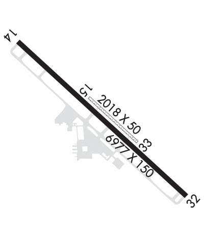
| Lat: N 4229.5 Long: W 07627.5 Elev: 1099 Var: +12 Longest Runway: 6977 | ||
| Clr Del: 121.8 Dept. ATIS: 125.17 Arr. ATIS: 125.17 AWOS: 125.17 Ground: 121.8 Tower: 119.6 | ||
| ||||||||||||||||||||||||||||||||||||||||||||
| ||||||||||||||||||||||||||||||||||||||||||||
| ||||||||||||||||||||||||||||||||||||||||||||
| Rwy | Rwy | |||||||
| 6977x150 | 6977' | 6977x150 | 6977' | 108.70 - 324° | ||||
| 2018x50 | 2018' | 2018x50 | 2018' | |||||
| Runway ID | Single Wheel | Double Wheel | Double Tandem Wheel | Dual Double Wheel |
| 14/32 | 100,000 | 192,000 | 574,000 | 1,044,000 |
| 15/33 | N/A | N/A | N/A | N/A |
| These numbers are Advisory and are not limits. The Airport Manager should have more accurate Weight Limits | ||||
 Airport Diagram might not be current. | |
| Facility Name: | ITHACA TOMPKINS INTL |
| City Name: | ITHACA |
| County: | TOMPKINS |
| State abbrev: | NY |
| State Name: | NEW YORK |
| Ownership: | PUBLICLY OWNED |
| Use: | OPEN TO THE PUBLIC |
| Owner's Name: | TOMPKINS COUNTY |
| Address: | 125 EAST COURT ST |
| ITHACA, NY 14850 | |
| Owner's Phone: | 607-274-5551 |
| Manager's Name: | ROXAN NOBLE |
| Address: | 72 BROWN RD |
| ITHACA, NY 14850 | |
| Phone: | 607-257-0456 |
| FAA Region: | EASTERN |
| FAA Field Office: | NYC |
| Date | Sunrise | Sunset |
|---|---|---|
| 06/08/26 Monday | 5:29 | 20:41 |
| 06/09/26 Tuesday | 5:28 | 20:42 |
| 06/10/26 Wednesday | 5:28 | 20:42 |
| 06/11/26 Thursday | 5:28 | 20:43 |
| 06/12/26 Friday | 5:28 | 20:43 |
| 06/13/26 Saturday | 5:28 | 20:44 |
| 06/14/26 Sunday | 5:28 | 20:44 |
| 06/15/26 Monday | 5:28 | 20:45 |
| 06/16/26 Tuesday | 5:28 | 20:45 |
| 06/17/26 Wednesday | 5:28 | 20:46 |
| 06/18/26 Thursday | 5:28 | 20:46 |
| 06/19/26 Friday | 5:28 | 20:46 |
| 06/20/26 Saturday | 5:28 | 20:46 |
| 06/21/26 Sunday | 5:28 | 20:47 |
| Airport Attendance Schedule | CONTINUOUS; FBO AVBL 0600-1900; FBO SVCS CTC 131.6; AFT HRS CALL 607-279-0392 OR 800-876-1551. |
| Airport Status | OPERATIONAL (This Status can change at any time - please check NOTAMS) |
| Airport Lighting Schedule | WHEN ATCT CLSD ACTVT MALSR RWY 32; HIRL RWY 14/32; TWY LGTS - CTAF. PAPI RWYS 14 & 32 OPR CONSLY. |
| Airport Storage Available | Tie Downs, Hanger |
| Extra Services Available | Charter, Flight Instruction, Aircraft Rental |
| Wind Indicator | YES - (lighted) |
| Control Tower | YES |
| CTAF Frequency | 119.600 |
| Unicom Frequency | 122.950; UNICOM UNMON. |
| Rotating Beacon Color | WG |
| Segmented Circle | NO |
| Landing Fee | YES; LDG FEE FOR TSNT ACFT. |
| Airport Inspected | FEDERAL - performed by FAA AIRPORTS FIELD PERSONNEL |
| Inspection Date | 07/22/2025 |
| Type of Fuel Available | Grade 100LL, JET A (freeze point -40C) |
| Airframe Repair Service | MAJOR |
| Power Plant Repair Service | MAJOR |
| Latitude | N4229.5 |
| Longitude | W07627.5 (ESTIMATED) |
| Arpt Elevation | 1099ft (SURVEYED) |
| Magnetic Variation | 12W |
| 3 miles NE | of ITHACA |
| Traffic Pattern Altitude | |
| Sectional Chart | NEW YORK |
| Operations (Reported) | Yearly | Avg. Daily |
|---|---|---|
| General Aviation Transient | 0 | 0 |
| General Aviation Local | 0 | 0 |
| Air Taxi | 0 | 0 |
| Commerical | 0 | 0 |
| Commuter | 0 | 0 |
| Military | 0 | 0 |
| Aircraft based on Field | |
|---|---|
| General Aviation Singles | 0 |
| General Aviation Multi | 0 |
| Jet Aircraft | 0 |
| General Aviation Helicopters | 0 |
| Military Aircraft | 0 |
| Gliders | 0 |
| Ultralights | 0 |
| FSS on field | NO |
| FSS tie-in | BUFFALO |
| FSS Phone | 1-800-WX-BRIEF |
| Who issues Notams | ITH |
| Notam D service at airport | YES |
| ARTCC Name | NEW YORK |
| Airport Certification | AIRPORT RECEIVING SCHEDULED AIR CARRIER SERVICE FROM CARRIERS CERTIFICATED BY THE CIVIL AERONAUTICS BOARD |
| Aircraft Rescue & Firefighting Index | AIRPORT HAS A CERTIFICATE UNDER CFR PART 139 |
| Airport of Entry | No |
| Custom Landing Rights | No |
| Joint Civil/Military | No |
| Military Landing rights | YES |
| NATIONAL PLAN OF INTEGRATED AIRPORT SYSTEMS (NPIAS) |
| GRANT AGREEMENTS UNDER FAAP/ADAP/AIP |
| ASSURANCES PURSUANT TO TITLE VI, CIVIL RIGHTS ACT OF 1964 |
| DEER & FLOCKS OF BIRDS ON & INVOF ARPT. |
| COLD TEMPERATURE AIRPORT. ALTITUDE CORRECTION REQUIRED AT OR BELOW -18C. |
| FOR CD IF UNA TO CTC ON FSS FREQ, CTC NEW YORK ARTCC. |
| FOR CD WHEN TWR AND ELM APCH CLSD CTC NEW YORK ARTCC. |
| PILOTS CONDUCTING EFVS OPS; BE AWARE LED ALS IN USE RWY 32. |
| RWY 15/3 3 RWY 15/33 CLSD NGTS, WINTER MONTHS AND AFT HVY RAIN. |
| RWY 14/3 2 PCR VALUE: 980/F/B/X/T |
Airport Communications & Frequencies:
| |||||||||||||||||||||||||||
| Runway: 14 | Runway: 32 | ||
| Mag heading: | 145° | Mag heading: | 325° |
| Rwy Slope: | .32% Up | Rwy Slope: | -.32% Down |
| Approach: | Approach: | ILS | |
| Pattern: | Left Traffic | Pattern: | Left Traffic |
| Markings: | PRECISION INSTRUMENT | Markings: | PRECISION INSTRUMENT |
| Marking Condition: | GOOD | Marking Condition: | GOOD |
| Arresting Dev: | Arresting Dev: | ||
| Lat & Long: | N4229.9 W07628.1 | Lat. & Long.: | N4229.1 W07627.0 |
| Elev: | 1076.5 ft. MSL | Elev: | 1099.0 ft. MSL |
| TCH: | 50 ft. AGL | TCH: | 53 ft. AGL |
| Visual Glide Path: | 3.00 degrees | Visual Glide Path: | 3.20 degrees |
| Displaced Threshold: | No | Displaced Threshold: | No |
| Touchdown Zone: | YES | Touchdown Zone: | YES |
| Touchdown Elev.: | 1082.7 feet | Touchdown Elev.: | 1099.0 feet |
| Visual Glide Slope: | 4-Light PAPI on LEFT side of Runway | Visual Glide Slope: | 4-Light PAPI on LEFT side of Runway |
| RVR Equipment: | ROLLOUT | RVR Equipment: | TOUCHDOWN |
| RVV Equipment: | NO | RVV Equipment: | NO |
| Approach Lights: | Approach Lights: | MALSR - 1,400 foot medium intensity approach lighting system with runway alignment indicator lights | |
| REIL: | NO | REIL: | NO |
| Centerline Lights: | NO | Centerline Lights: | NO |
| Touchdown lights: | NO | Touchdown lights: | NO |
| Runway Category: | Runway with a Non-precision Approach having visibility minimums greater than 3/4 mile | Runway Category: | Precision Instrument Runway |
| Declared Distances: | TORA:6977' TODA:6977' ASDA:6602' LDA:6602' | Declared Distances: | TORA:6977' TODA:6977' ASDA:6602' LDA:6602' |
| Obstructions: | Obstructions: | TREES | |
| Marked: | Marked: | NOT Marked/Lighted | |
| Clearance slope: | 50:1 | Clearance slope: | 31:1 |
| Obstruction height: | Obstruction height: | 642 feet AGL | |
| Dist. from runway: | Dist. from runway: | 20360 feet | |
| Centerline offset: | Centerline offset: | 2000 feet right of centerline | |
| Comments: | Comments: |
| Runway: 15 | Runway: 33 | ||
| Mag heading: | 144° | Mag heading: | 325° |
| Rwy Slope: | .29% Up | Rwy Slope: | -.29% Down |
| Approach: | Approach: | ||
| Pattern: | Left Traffic | Pattern: | Left Traffic |
| Markings: | Markings: | ||
| Marking Condition: | RWY 15/33 THRS MKD WITH WHITE LIME BAR; EDGES MKD WITH REFLECTORS. | Marking Condition: | |
| Arresting Dev: | Arresting Dev: | ||
| Lat & Long: | N4229.6 W07627.6 | Lat. & Long.: | N4229.4 W07627.3 |
| Elev: | 1080.5 ft. MSL | Elev: | 1086.4 ft. MSL |
| TCH: | TCH: | ||
| Visual Glide Path: | Visual Glide Path: | ||
| Displaced Threshold: | No | Displaced Threshold: | No |
| Touchdown Zone: | YES | Touchdown Zone: | YES |
| Touchdown Elev.: | 1086.4 feet | Touchdown Elev.: | 1086.4 feet |
| Visual Glide Slope: | Visual Glide Slope: | ||
| RVR Equipment: | RVR Equipment: | ||
| RVV Equipment: | NO | RVV Equipment: | NO |
| Approach Lights: | Approach Lights: | ||
| REIL: | NO | REIL: | NO |
| Centerline Lights: | NO | Centerline Lights: | NO |
| Touchdown lights: | NO | Touchdown lights: | NO |
| Runway Category: | Runway with a Visual Approach | Runway Category: | Runway with a Visual Approach |
| Declared Distances: | Declared Distances: | ||
| Obstructions: | ROAD | Obstructions: | ANT |
| Marked: | NOT Marked/Lighted | Marked: | LIGHTED |
| Clearance slope: | 15:1 | Clearance slope: | 21:1 |
| Obstruction height: | 15 feet AGL | Obstruction height: | 55 feet AGL |
| Dist. from runway: | 238 feet | Dist. from runway: | 1200 feet |
| Centerline offset: | Centerline offset: | 50 feet right of centerline | |
| Comments: | Comments: |
Thanks for using FltPlan.com
all rights reserved © 1999-2026 by Flight Plan LLC
