| SLOULIN FLD INTL (CLSD) WILLISTON ND |
| |
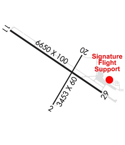
| Lat: N 4810.7 Long: W 10338.5 Elev: 1982 Var: -09 Longest Runway: 6650 | ||
| AWOS: 125.92 CTAF: 122.8 | ||
| ||||||||||||||||||||||||||||||
| ||||||||||||||||||||||||||||||
| ||||||||||||||||||||||||||||||
| ||||||||||||||||||||||||||||||
| Rwy | Rwy | |||||||
| 3453x60 | 3453' | 3453x60 | 3453' | |||||
| 6650x100 | 6650' | 6650x100 | 6650' | 108.70 - 295° | ||||
| Runway ID | Single Wheel | Double Wheel | Double Tandem Wheel | Dual Double Wheel |
| 02/20 | 13,000 | N/A | N/A | N/A |
| 11/29 | 16,000 | 25,000 | N/A | N/A |
| These numbers are Advisory and are not limits. The Airport Manager should have more accurate Weight Limits | ||||
 Airport Diagram might not be current. | |
| Facility Name: | SLOULIN FLD INTL |
| City Name: | WILLISTON |
| County: | WILLIAMS |
| State abbrev: | ND |
| State Name: | NORTH DAKOTA |
| Ownership: | PUBLICLY OWNED |
| Use: | OPEN TO THE PUBLIC |
| Owner's Name: | CITY OF WILLISTON |
| Address: | PO BOX 1306 |
| WILLISTON, ND 58801 | |
| Owner's Phone: | 701-774-8594 |
| Manager's Name: | ANTHONY DUDAS |
| Address: | P O BOX 1306 |
| WILLISTON, ND 58801 | |
| Phone: | 701-774-8594 |
| FAA Region: | GREAT LAKES |
| FAA Field Office: | DMA |
| Date | Sunrise | Sunset |
|---|---|---|
| 10/31/19 Thursday | 8:38 | 18:38 |
| 11/01/19 Friday | 8:40 | 18:36 |
| 11/02/19 Saturday | 8:41 | 18:34 |
| 11/03/19 Sunday | 7:43 | 17:33 |
| 11/04/19 Monday | 7:44 | 17:31 |
| 11/05/19 Tuesday | 7:46 | 17:30 |
| 11/06/19 Wednesday | 7:47 | 17:28 |
| 11/07/19 Thursday | 7:49 | 17:27 |
| 11/08/19 Friday | 7:51 | 17:25 |
| 11/09/19 Saturday | 7:52 | 17:24 |
| 11/10/19 Sunday | 7:54 | 17:23 |
| 11/11/19 Monday | 7:55 | 17:21 |
| 11/12/19 Tuesday | 7:57 | 17:20 |
| 11/13/19 Wednesday | 7:58 | 17:19 |
| Airport Attendance Schedule | APR-OCT 7 Days A Week 0800-2100, NOV-MAR 7 Days A Week 0800-1900 |
| Airport Status | CLOSED PERMANENTLY (This Status can change at any time - please check NOTAMS) |
| Airport Lighting Schedule | ACTVT MALSR RWY 29; REIL RWY 02 & 11; PAPI RWY 02, 11, 20, 29; MIRL RWY 02/20 - CTAF. MIRL RWY 11/29 PRESET ON LOW INTST DUSK-DAWN; TO INCR INTST - CTAF. |
| Airport Storage Available | Tie Downs, Hanger |
| Extra Services Available | Air Freight, Air Ambulance, Cargo Handling, Charter, Flight Instruction, Aircraft Rental, Annual Surveying |
| Wind Indicator | YES - (lighted) |
| Control Tower | NO |
| CTAF Frequency | 122.800 |
| Unicom Frequency | 122.800 |
| Rotating Beacon Color | CLEAR-GREEN (Light Land Airport) |
| Segmented Circle | YES |
| Landing Fee | NO |
| Airport Inspected | FEDERAL - performed by FAA AIRPORTS FIELD PERSONNEL |
| Inspection Date | 05/22/2019 |
| Type of Fuel Available | Grade 100LL, JET A (freeze point -40C); AFT HRS FUEL CTC - (701) 774-2300. |
| Airframe Repair Service | MAJOR |
| Power Plant Repair Service | MAJOR |
| Latitude | N4810.7 |
| Longitude | W10338.5 (ESTIMATED) |
| Arpt Elevation | 1981ft (ESTIMATED) |
| Magnetic Variation | 09E |
| 2 miles N | of WILLISTON |
| Traffic Pattern Altitude | 800 |
| Sectional Chart | BILLINGS |
| Operations (Reported) | Yearly | Avg. Daily |
|---|---|---|
| General Aviation Transient | 29646 | 81 |
| General Aviation Local | 6533 | 18 |
| Air Taxi | 3500 | 10 |
| Commerical | 3285 | 9 |
| Commuter | 0 | 0 |
| Military | 50 | 0 |
| Aircraft based on Field | |
|---|---|
| General Aviation Singles | 42 |
| General Aviation Multi | 5 |
| Jet Aircraft | 0 |
| General Aviation Helicopters | 2 |
| Military Aircraft | 0 |
| Gliders | 0 |
| Ultralights | 0 |
| FSS on field | NO |
| FSS tie-in | GRAND FORKS |
| FSS Phone | 1-800-WX-BRIEF |
| Who issues Notams | ISN |
| Notam D service at airport | YES |
| ARTCC Name | SALT LAKE CITY |
| Airport Certification | AIRPORT RECEIVING SCHEDULED AIR CARRIER SERVICE FROM CARRIERS CERTIFICATED BY THE CIVIL AERONAUTICS BOARD |
| Aircraft Rescue & Firefighting Index | AIRPORT HAS A CERTIFICATE UNDER CFR PART 139 |
| Airport of Entry | YES |
| Custom Landing Rights | No |
| Joint Civil/Military | No |
| Military Landing rights | YES |
| NATIONAL PLAN OF INTEGRATED AIRPORT SYSTEMS (NPIAS) |
| GRANT AGREEMENTS UNDER FAAP/ADAP/AIP |
| ASSURANCES PURSUANT TO TITLE VI, CIVIL RIGHTS ACT OF 1964 |
| THIS AIRPORT HAS BEEN SURVEYED BY THE NATIONAL GEODETIC SURVEY. |
| BIRDS AND DEER ON AND INVOF ARPT. |
| 48 HRS PPR FOR UNSKED ACR OPNS WITH MORE THAN 30 PSGR SEATS CTC - AMGR. RWY 02/20 NOT AVBL FOR SKEDD AIR CARRIER OPS INVOLVING AIRCRAFT DESIGNED FOR 10 OR MORE PSGR SEATS AND UNSKED AIR CARRIER OPS WITH MORE THAN 30 PSGR SEATS. |
| U.S. CUSTOMS CALL - 701-770-2460/2461/2849. |
| COLD TEMPERATURE RESTRICTED AIRPORT. ALTITUDE CORRECTION REQUIRED AT OR BELOW -36C. |
| ARPT SFC COND UNMON 0100 - 0500 DAILY. |
| ARPT SELF SVC FUEL NOT AVBL. |
| (ARPT STATUS) ARPT CLSD PERMLY. |
| RWY 11 165 FT POWERLINE ACROSS APCH END 3500 FT TO 3700 FT FM RWY END. |
| RWY 29 64 FT UNLGTD CRANE 0.64 NM SW APCH END. |
Airport Communications & Frequencies:
| |||||||||
| Runway: 02 | Runway: 20 | ||
| Mag heading: | 21° | Mag heading: | 201° |
| Rwy Slope: | .03% Up | Rwy Slope: | -.03% Down |
| Approach: | Approach: | ||
| Pattern: | Left Traffic | Pattern: | Right Traffic |
| Markings: | BASIC | Markings: | BASIC |
| Marking Condition: | GOOD | Marking Condition: | GOOD |
| Arresting Dev: | Arresting Dev: | ||
| Lat & Long: | N4810.3 W10338.6 | Lat. & Long.: | N4810.8 W10338.2 |
| Elev: | 1915.4 ft. MSL | Elev: | 1916.5 ft. MSL |
| TCH: | 32 ft. AGL | TCH: | 32 ft. AGL |
| Visual Glide Path: | 4.00 degrees | Visual Glide Path: | 4.00 degrees |
| Displaced Threshold: | No | Displaced Threshold: | No |
| Touchdown Zone: | YES | Touchdown Zone: | YES |
| Touchdown Elev.: | 1919.5 feet | Touchdown Elev.: | 1919.5 feet |
| Visual Glide Slope: | 2-Light PAPI on LEFT side of Runway | Visual Glide Slope: | 2-Light PAPI on LEFT side of Runway |
| RVR Equipment: | RVR Equipment: | ||
| RVV Equipment: | NO | RVV Equipment: | NO |
| Approach Lights: | Approach Lights: | ||
| REIL: | YES | REIL: | YES |
| Centerline Lights: | NO | Centerline Lights: | NO |
| Touchdown lights: | NO | Touchdown lights: | NO |
| Runway Category: | Runway with a Visual Approach | Runway Category: | Runway with a Visual Approach |
| Declared Distances: | TORA:3453' TODA:3453' ASDA:3453' LDA:3453' | Declared Distances: | TORA:3453' TODA:3453' ASDA:3453' LDA:3453' |
| Obstructions: | POLE | Obstructions: | |
| Marked: | NOT Marked/Lighted | Marked: | |
| Clearance slope: | 29:1 | Clearance slope: | 50:1 |
| Obstruction height: | 39 feet AGL | Obstruction height: | |
| Dist. from runway: | 1347 feet | Dist. from runway: | |
| Centerline offset: | 68 left of centerline | Centerline offset: | |
| Comments: | Comments: |
| Runway: 11 | Runway: 29 | ||
| Mag heading: | 115° | Mag heading: | 295° |
| Rwy Slope: | -1.31% Down | Rwy Slope: | 1.31% Up |
| Approach: | Approach: | ILS | |
| Pattern: | Right Traffic | Pattern: | Left Traffic |
| Markings: | PRECISION INSTRUMENT | Markings: | PRECISION INSTRUMENT |
| Marking Condition: | GOOD | Marking Condition: | GOOD |
| Arresting Dev: | Arresting Dev: | ||
| Lat & Long: | N4811.0 W10339.3 | Lat. & Long.: | N4810.4 W10337.9 |
| Elev: | 1981.5 ft. MSL | Elev: | 1894.1 ft. MSL |
| TCH: | 37 ft. AGL | TCH: | 49 ft. AGL |
| Visual Glide Path: | 3.60 degrees | Visual Glide Path: | 3.00 degrees |
| Displaced Threshold: | No | Displaced Threshold: | No |
| Touchdown Zone: | YES | Touchdown Zone: | YES |
| Touchdown Elev.: | 1981.5 feet | Touchdown Elev.: | 1929.9 feet |
| Visual Glide Slope: | 4-Light PAPI on LEFT side of Runway | Visual Glide Slope: | 4-Light PAPI on LEFT side of Runway |
| RVR Equipment: | RVR Equipment: | ||
| RVV Equipment: | NO | RVV Equipment: | NO |
| Approach Lights: | Approach Lights: | MALSR - 1,400 foot medium intensity approach lighting system with runway alignment indicator lights | |
| REIL: | YES | REIL: | NO |
| Centerline Lights: | NO | Centerline Lights: | NO |
| Touchdown lights: | NO | Touchdown lights: | NO |
| Runway Category: | Runway with a Non-precision Approach having visibility minimums greater than 3/4 mile | Runway Category: | Precision Instrument Runway |
| Declared Distances: | TORA:6650' TODA:6650' ASDA:6650' LDA:6650' | Declared Distances: | TORA:6650' TODA:6650' ASDA:6650' LDA:6650' |
| Obstructions: | PLINE | Obstructions: | |
| Marked: | LIGHTED | Marked: | |
| Clearance slope: | 21:1 | Clearance slope: | 50:1 |
| Obstruction height: | 155 feet AGL | Obstruction height: | |
| Dist. from runway: | 3478 feet | Dist. from runway: | |
| Centerline offset: | 249 left of centerline | Centerline offset: | |
| Comments: | Comments: |
Thanks for using FltPlan.com
all rights reserved © 1999-2019 by Flight Plan LLC