
| IMPERIAL COUNTY IMPERIAL CA |
| |
| Lat: N 3250.1 Long: W 11534.7 Elev: -54 Var: -14 Longest Runway: 5308 | ||
| AWOS: 132.17 CTAF: 122.7 | ||
| ||||||||||||||||||||||||||||||||||||||||||||
| ||||||||||||||||||||||||||||||||||||||||||||
| ||||||||||||||||||||||||||||||||||||||||||||
| Rwy | Rwy | |||||||
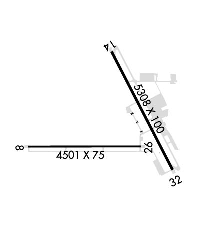
| 4501x75 | 4501' | 4501x75 | 4501' | |||||
| 5308x100 | 5308' | 5308x100 | 5308' | |||||
| Runway ID | Single Wheel | Double Wheel | Double Tandem Wheel | Dual Double Wheel |
| 08/26 | 50,000 | 50,000 | N/A | N/A |
| 14/32 | 60,000 | 80,000 | 102,000 | 130,000 |
| These numbers are Advisory and are not limits. The Airport Manager should have more accurate Weight Limits | ||||
 Airport Diagram might not be current. | |
| Facility Name: | IMPERIAL COUNTY |
| City Name: | IMPERIAL |
| County: | IMPERIAL |
| State abbrev: | CA |
| State Name: | CALIFORNIA |
| Ownership: | PUBLICLY OWNED |
| Use: | OPEN TO THE PUBLIC |
| Owner's Name: | IMPERIAL COUNTY |
| Address: | 1099 AIRPORT ROAD |
| IMPERIAL, CA 92251 | |
| Owner's Phone: | (442) 265-3220 |
| Manager's Name: | SANDRA GUTIERREZ |
| Address: | 1099 AIRPORT ROAD |
| IMPERIAL, CA 92251 | |
| Phone: | (442) 265-3220 |
| FAA Region: | WESTERN-PACIFIC |
| FAA Field Office: | LAX |
| Date | Sunrise | Sunset |
|---|---|---|
| 09/24/21 Friday | 6:32 | 18:36 |
| 09/25/21 Saturday | 6:32 | 18:35 |
| 09/26/21 Sunday | 6:33 | 18:34 |
| 09/27/21 Monday | 6:34 | 18:32 |
| 09/28/21 Tuesday | 6:34 | 18:31 |
| 09/29/21 Wednesday | 6:35 | 18:30 |
| 09/30/21 Thursday | 6:36 | 18:28 |
| 10/01/21 Friday | 6:36 | 18:27 |
| 10/02/21 Saturday | 6:37 | 18:26 |
| 10/03/21 Sunday | 6:38 | 18:24 |
| 10/04/21 Monday | 6:38 | 18:23 |
| 10/05/21 Tuesday | 6:39 | 18:22 |
| 10/06/21 Wednesday | 6:40 | 18:21 |
| 10/07/21 Thursday | 6:40 | 18:19 |
| Airport Attendance Schedule | 7 Days A Week 0700-1630 |
| Airport Status | OPERATIONAL (This Status can change at any time - please check NOTAMS) |
| Airport Lighting Schedule | ACTVT MIRL RWYS 08/26 & 14/32 - CTAF. |
| Airport Storage Available | Tie Downs |
| Extra Services Available | Air Freight, Crop Dusting, Air Ambulance, Charter |
| Wind Indicator | YES - (unlit) |
| Control Tower | NO |
| CTAF Frequency | 122.700 |
| Unicom Frequency | 122.700 |
| Rotating Beacon Color | CLEAR-GREEN (Light Land Airport) |
| Segmented Circle | YES |
| Landing Fee | YES; OVERNIGHT TIE-DOWN FEE. |
| Airport Inspected | FEDERAL - performed by FAA AIRPORTS FIELD PERSONNEL |
| Inspection Date | 01/28/2020 |
| Type of Fuel Available | Grade 100LL, JET A (freeze point -40C) |
| Airframe Repair Service | NONE |
| Power Plant Repair Service | NONE |
| Latitude | N3250.1 |
| Longitude | W11534.7 (ESTIMATED) |
| Arpt Elevation | -54ft (SURVEYED) |
| Magnetic Variation | 14E |
| 1 miles S | of IMPERIAL |
| Traffic Pattern Altitude | |
| Sectional Chart | PHOENIX |
| Operations (Reported) | Yearly | Avg. Daily |
|---|---|---|
| General Aviation Transient | 3550 | 10 |
| General Aviation Local | 5850 | 16 |
| Air Taxi | 0 | 0 |
| Commerical | 1220 | 3 |
| Commuter | 0 | 0 |
| Military | 3748 | 10 |
| Aircraft based on Field | |
|---|---|
| General Aviation Singles | 35 |
| General Aviation Multi | 2 |
| Jet Aircraft | 0 |
| General Aviation Helicopters | 3 |
| Military Aircraft | 0 |
| Gliders | 0 |
| Ultralights | 0 |
| FSS on field | NO |
| FSS tie-in | SAN DIEGO |
| FSS Phone | 1-800-WX-BRIEF |
| Who issues Notams | IPL |
| Notam D service at airport | YES |
| ARTCC Name | LOS ANGELES |
| Airport Certification | AIRPORT RECEIVING SCHEDULED AIR CARRIER SERVICE FROM CARRIERS CERTIFICATED BY THE CIVIL AERONAUTICS BOARD; RWY 8/26 NOT AVBL FOR SKED ACR OPNS WITH MORE THAN 9 PSGR SEATS OR UNSKED ACR AT LEAST 31 PSGR SEATS. |
| Aircraft Rescue & Firefighting Index | AIRPORT HAS A CERTIFICATE UNDER CFR PART 139 |
| Airport of Entry | No |
| Custom Landing Rights | No |
| Joint Civil/Military | No |
| Military Landing rights | YES |
| NATIONAL PLAN OF INTEGRATED AIRPORT SYSTEMS (NPIAS) |
| GRANT AGREEMENTS UNDER FAAP/ADAP/AIP |
| ASSURANCES PURSUANT TO TITLE VI, CIVIL RIGHTS ACT OF 1964 |
| PPR FOR NON-SKEDD AIR CARRIER ARFF SER, CONTACT AMER 442-264-3220. |
| TWY C3 CLSD BTN RWY 14/32 AND TWY C5. |
| NOISE ABATEMENT: NOISE SENSITIVE AREA NE EDGE OF AP: SCHOOLS AND RESIDENTIAL. CONDS PMTG, HEL ARRS SHOULD BE TO RWY 32, TOUCHDOWN MIDFIELD (BTN TWY A4 AND A3). HEL DEPARTURES SHOULD BE FM RWY 14 MIDFIELD. WHEN CONDS REQ RWY 32 DEPARTURE, MNTN RWY CNTRLN FOR 1.5 NM BEFORE INITIATING TURN. FOR HEL TRNG PATS/AUTOROTATIONS USE RWY 08/26, MAX OF 3 CIRCUITS. BTN SS-SR AVOID CONS PAT CIRCUITS. |
| FOR CD IF UNA TO CTC ON FSS FREQ, CTC LOS ANGELES ARTCC AT 661-575-2079. |
| AVOID NAF EL CENTRO TFC; ACFT DEPG RWY 26 MAKE IMT RIGHT TURN - STAY BELOW 1000 FT; CTC NAF TWR 119.1 FOR ADZY. |
| FRQ HIGH-SPD MIL JET TFC TRANSITS IMPERIAL COUNTY TFC AREA WB DESCENDING VFR TO NAF EL CENRTO. AVOID 2500 FT TO 3500 FT MSL NEAR IMPERIAL COUNTY. CTC NAF TWR 119.1 FOR NAVY TFC ADZY. |
| RADIO ANT +70 FT LCTD ON CTL TWR AT MIDFIELD RWY 14/32 AND 500 FT WEST RWY CNTRLN. |
Airport Communications & Frequencies:
| |||||||||
| Runway: 08 | Runway: 26 | ||
| Mag heading: | 76° | Mag heading: | 256° |
| Rwy Slope: | .00% Up | Rwy Slope: | .00% Down |
| Approach: | Approach: | ||
| Pattern: | Left Traffic | Pattern: | Right Traffic |
| Markings: | BASIC | Markings: | BASIC |
| Marking Condition: | GOOD | Marking Condition: | GOOD |
| Arresting Dev: | Arresting Dev: | ||
| Lat & Long: | N3249.9 W11535.4 | Lat. & Long.: | N3249.9 W11534.5 |
| Elev: | -55.1 ft. MSL | Elev: | -55.0 ft. MSL |
| TCH: | 45 ft. AGL | TCH: | 45 ft. AGL |
| Visual Glide Path: | 3.00 degrees | Visual Glide Path: | 3.00 degrees |
| Displaced Threshold: | No | Displaced Threshold: | No |
| Touchdown Zone: | YES | Touchdown Zone: | YES |
| Touchdown Elev.: | -54.5 feet | Touchdown Elev.: | -54.4 feet |
| Visual Glide Slope: | 4-Light PAPI on LEFT side of Runway | Visual Glide Slope: | 4-Light PAPI on LEFT side of Runway |
| RVR Equipment: | RVR Equipment: | ||
| RVV Equipment: | NO | RVV Equipment: | NO |
| Approach Lights: | Approach Lights: | ||
| REIL: | NO | REIL: | NO |
| Centerline Lights: | NO | Centerline Lights: | NO |
| Touchdown lights: | NO | Touchdown lights: | NO |
| Runway Category: | Runway with a Visual Approach | Runway Category: | Runway with a Visual Approach |
| Declared Distances: | TORA:4501' TODA:4501' ASDA:4501' LDA:4501' | Declared Distances: | TORA:4501' TODA:4501' ASDA:4501' LDA:4501' |
| Obstructions: | PLINE | Obstructions: | POLE |
| Marked: | MARKED and LIGHTED | Marked: | NOT Marked/Lighted |
| Clearance slope: | 23:1 | Clearance slope: | 42:1 |
| Obstruction height: | 59 feet AGL | Obstruction height: | 32 feet AGL |
| Dist. from runway: | 1600 feet | Dist. from runway: | 1575 feet |
| Centerline offset: | Centerline offset: | 250 feet right of centerline | |
| Comments: | Comments: |
| Runway: 14 | Runway: 32 | ||
| Mag heading: | 139° | Mag heading: | 319° |
| Rwy Slope: | .02% Up | Rwy Slope: | -.02% Down |
| Approach: | Approach: | ||
| Pattern: | Left Traffic | Pattern: | Right Traffic |
| Markings: | NONPRECISION INSTRUMENT | Markings: | NONPRECISION INSTRUMENT |
| Marking Condition: | GOOD | Marking Condition: | GOOD |
| Arresting Dev: | Arresting Dev: | ||
| Lat & Long: | N3250.6 W11534.8 | Lat. & Long.: | N3249.8 W11534.3 |
| Elev: | -55.1 ft. MSL | Elev: | -53.9 ft. MSL |
| TCH: | 45 ft. AGL | TCH: | 45 ft. AGL |
| Visual Glide Path: | 3.00 degrees | Visual Glide Path: | 3.00 degrees |
| Displaced Threshold: | No | Displaced Threshold: | No |
| Touchdown Zone: | YES | Touchdown Zone: | YES |
| Touchdown Elev.: | -54.7 feet | Touchdown Elev.: | -53.6 feet |
| Visual Glide Slope: | 4-Light PAPI on LEFT side of Runway | Visual Glide Slope: | 4-Light PAPI on LEFT side of Runway |
| RVR Equipment: | RVR Equipment: | ||
| RVV Equipment: | NO | RVV Equipment: | NO |
| Approach Lights: | Approach Lights: | ||
| REIL: | NO | REIL: | NO |
| Centerline Lights: | NO | Centerline Lights: | NO |
| Touchdown lights: | NO | Touchdown lights: | NO |
| Runway Category: | Runway with a Visual Approach | Runway Category: | Runway with a Visual Approach |
| Declared Distances: | TORA:5304' TODA:5304' ASDA:5304' LDA:5304' | Declared Distances: | TORA:5304' TODA:5304' ASDA:5304' LDA:5304' |
| Obstructions: | FENCE | Obstructions: | ROAD |
| Marked: | LIGHTED | Marked: | NOT Marked/Lighted |
| Clearance slope: | 25:1 | Clearance slope: | 26:1 |
| Obstruction height: | 9 feet AGL | Obstruction height: | 15 feet AGL |
| Dist. from runway: | 425 feet | Dist. from runway: | 600 feet |
| Centerline offset: | 130 left of centerline | Centerline offset: | 150 feet right of centerline |
| Comments: | Comments: |
Thanks for using FltPlan.com
all rights reserved © 1999-2021 by Flight Plan LLC
