| FALLS INTL INTERNATIONAL FALLS MN |
| |
| Lat: N 4833.9 Long: W 09324.1 Elev: 1184 Var: -03 Longest Runway: 7400 | ||
| AWOS: 120.0 CTAF: 122.8 | ||
| ||||||||||||||||||||||||||||||||||||||||||||
| ||||||||||||||||||||||||||||||||||||||||||||
| ||||||||||||||||||||||||||||||||||||||||||||
| FBOs at nearby airports who want your business: | |||||||||||||||||
| |||||||||||||||||
| Rwy | Rwy | |||||||
| 2999x75 | 2999' | 2999x75 | 2999' | |||||
| 7400x150 | 7400' | 109.10 - 132° | 7400x150 | 7400' | 111.95 - 312° | |||
| 6200x100 | 6200' | 6200x100 | 6200' | |||||
| Runway ID | Single Wheel | Double Wheel | Double Tandem Wheel | Dual Double Wheel |
| 04/22 | 12,500 | N/A | N/A | N/A |
| 13/31 | 100,000 | 125,000 | 190,000 | N/A |
| 14/32 | N/A | N/A | N/A | N/A |
| These numbers are Advisory and are not limits. The Airport Manager should have more accurate Weight Limits | ||||
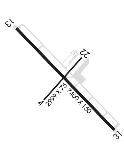 Airport Diagram might not be current. | |
| Facility Name: | FALLS INTL-EINARSON FLD |
| City Name: | INTERNATIONAL FALLS |
| County: | KOOCHICHING |
| State abbrev: | MN |
| State Name: | MINNESOTA |
| Ownership: | PUBLICLY OWNED |
| Use: | OPEN TO THE PUBLIC |
| Owner's Name: | CITY OF INTL FALLS |
| Address: | PO BOX 392 |
| INTERNATIONAL FALLS, MN 56649-0392 | |
| Owner's Phone: | 218-283-4461 |
| Manager's Name: | THOR EINARSON |
| Address: | 3214 2ND AVE E; THOR@EINARSONFLYING.COM. |
| INTERNATIONAL FALLS, MN 56649-8955 | |
| Phone: | 218-283-4461 |
| FAA Region: | GREAT LAKES |
| FAA Field Office: | DMA |
| Date | Sunrise | Sunset |
|---|---|---|
| 09/24/21 Friday | 7:03 | 19:08 |
| 09/25/21 Saturday | 7:04 | 19:06 |
| 09/26/21 Sunday | 7:06 | 19:03 |
| 09/27/21 Monday | 7:07 | 19:01 |
| 09/28/21 Tuesday | 7:08 | 18:59 |
| 09/29/21 Wednesday | 7:10 | 18:57 |
| 09/30/21 Thursday | 7:11 | 18:55 |
| 10/01/21 Friday | 7:13 | 18:53 |
| 10/02/21 Saturday | 7:14 | 18:51 |
| 10/03/21 Sunday | 7:16 | 18:49 |
| 10/04/21 Monday | 7:17 | 18:47 |
| 10/05/21 Tuesday | 7:18 | 18:45 |
| 10/06/21 Wednesday | 7:20 | 18:43 |
| 10/07/21 Thursday | 7:21 | 18:41 |
| Airport Attendance Schedule | 7 Days A Week DALGT; FOR ATTENDANT 0000-0500 CALL 218-283-2712. |
| Airport Status | OPERATIONAL (This Status can change at any time - please check NOTAMS) |
| Airport Lighting Schedule | ACTVT MALSR RWY 13 & 31; REIL RWY 14 & 32; HIRL RWY 13/31; MIRL RWY 14/32 - CTAF. PAPI RWY 13, 31, 14, & 32 OPR CONSLY. |
| Airport Storage Available | Tie Downs, Hanger |
| Extra Services Available | Air Ambulance, Charter, Flight Instruction, Aircraft Rental |
| Wind Indicator | YES - (unlit) |
| Control Tower | NO |
| CTAF Frequency | 122.800 |
| Unicom Frequency | 122.800 |
| Rotating Beacon Color | CLEAR-GREEN (Light Land Airport) |
| Segmented Circle | NO |
| Landing Fee | NO |
| Airport Inspected | FEDERAL - performed by FAA AIRPORTS FIELD PERSONNEL |
| Inspection Date | 09/10/2019 |
| Type of Fuel Available | Grade 100LL, JET A (freeze point -40C) |
| Airframe Repair Service | None |
| Power Plant Repair Service | None |
| Latitude | N4833.9 |
| Longitude | W09324.1 (ESTIMATED) |
| Arpt Elevation | 1184ft (SURVEYED) |
| Magnetic Variation | 03E |
| 0 miles S | of INTERNATIONAL FALLS |
| Traffic Pattern Altitude | |
| Sectional Chart | TWIN CITIES |
| Operations (Reported) | Yearly | Avg. Daily |
|---|---|---|
| General Aviation Transient | 20000 | 55 |
| General Aviation Local | 15000 | 41 |
| Air Taxi | 2500 | 7 |
| Commerical | 1250 | 3 |
| Commuter | 0 | 0 |
| Military | 100 | 0 |
| Aircraft based on Field | |
|---|---|
| General Aviation Singles | 20 |
| General Aviation Multi | 0 |
| Jet Aircraft | 0 |
| General Aviation Helicopters | 0 |
| Military Aircraft | 0 |
| Gliders | 0 |
| Ultralights | 0 |
| FSS on field | NO |
| FSS tie-in | PRINCETON |
| FSS Phone | 1-800-WX-BRIEF |
| Who issues Notams | INL |
| Notam D service at airport | YES |
| ARTCC Name | MINNEAPOLIS |
| Airport Certification | AIRPORT RECEIVING SCHEDULED AIR CARRIER SERVICE FROM CARRIERS CERTIFICATED BY THE CIVIL AERONAUTICS BOARD; ACR OPS NA IN EXCESS OF 15 MINS BFR OR AFT SKEDD ARR/DEP TIMES WO PRIOR CDN WITH AMGR. 24 HR PPR FOR UNSKED ACR OPS GTR THAN 30 PAX SEATS - CALL AMGR. |
| Aircraft Rescue & Firefighting Index | AIRPORT HAS A CERTIFICATE UNDER CFR PART 139 |
| Airport of Entry | YES |
| Custom Landing Rights | YES |
| Joint Civil/Military | No |
| Military Landing rights | YES |
| NATIONAL PLAN OF INTEGRATED AIRPORT SYSTEMS (NPIAS) |
| GRANT AGREEMENTS UNDER FAAP/ADAP/AIP |
| ASSURANCES PURSUANT TO TITLE VI, CIVIL RIGHTS ACT OF 1964 |
| AGREEMENT UNDER DLAND OR DCLA HAS EXPIRED. |
| GULLS & DEER ON & INVOF ARPT. |
| FOR CD IF UNA TO CTC ON FSS FREQ, CTC MINNEAPOLIS ARTCC AT 651-463-5588. |
| FLD CONDS UNMON 0000-0500, CALL 218-283-2712. |
| RWY 04/2 2 CLSD TO SKEDD ACR OPS GTR THAN 9 PAX SEATS OR UNSKED ACR OPS GTR THAN 30 PAX SEATS. CLSD AT NGT. CLSD DRG WINTER MONTHS. |
Airport Communications & Frequencies:
| |||||||||
| Runway: 04 | Runway: 22 | ||
| Mag heading: | 39° | Mag heading: | 219° |
| Rwy Slope: | .37% Up | Rwy Slope: | -.37% Down |
| Approach: | Approach: | ||
| Pattern: | Left Traffic | Pattern: | Left Traffic |
| Markings: | BASIC | Markings: | BASIC |
| Marking Condition: | FAIR | Marking Condition: | FAIR |
| Arresting Dev: | Arresting Dev: | ||
| Lat & Long: | N4833.8 W09324.4 | Lat. & Long.: | N4834.1 W09323.9 |
| Elev: | 1170.0 ft. MSL | Elev: | 1181.1 ft. MSL |
| TCH: | TCH: | ||
| Visual Glide Path: | Visual Glide Path: | ||
| Displaced Threshold: | No | Displaced Threshold: | No |
| Touchdown Zone: | YES | Touchdown Zone: | YES |
| Touchdown Elev.: | 1181.1 feet | Touchdown Elev.: | 1181.1 feet |
| Visual Glide Slope: | Visual Glide Slope: | ||
| RVR Equipment: | RVR Equipment: | ||
| RVV Equipment: | NO | RVV Equipment: | NO |
| Approach Lights: | Approach Lights: | ||
| REIL: | NO | REIL: | NO |
| Centerline Lights: | NO | Centerline Lights: | NO |
| Touchdown lights: | NO | Touchdown lights: | NO |
| Runway Category: | Runway with a Visual Approach | Runway Category: | Runway with a Visual Approach |
| Declared Distances: | TORA:2999' TODA:2999' ASDA:2999' LDA:2999' | Declared Distances: | TORA:2999' TODA:2999' ASDA:2999' LDA:2999' |
| Runway: 13 | Runway: 31 | ||
| Mag heading: | 133° | Mag heading: | 313° |
| Rwy Slope: | -.24% Down | Rwy Slope: | .24% Up |
| Approach: | ILS | Approach: | ILS |
| Pattern: | Left Traffic | Pattern: | Left Traffic |
| Markings: | PRECISION INSTRUMENT | Markings: | PRECISION INSTRUMENT |
| Marking Condition: | GOOD | Marking Condition: | GOOD |
| Arresting Dev: | Arresting Dev: | ||
| Lat & Long: | N4834.4 W09324.8 | Lat. & Long.: | N4833.5 W09323.5 |
| Elev: | 1184.4 ft. MSL | Elev: | 1166.4 ft. MSL |
| TCH: | 52 ft. AGL | TCH: | 45 ft. AGL |
| Visual Glide Path: | 3.00 degrees | Visual Glide Path: | 3.00 degrees |
| Displaced Threshold: | No | Displaced Threshold: | No |
| Touchdown Zone: | YES | Touchdown Zone: | YES |
| Touchdown Elev.: | 1184.4 feet | Touchdown Elev.: | 1166.4 feet |
| Visual Glide Slope: | 4-Light PAPI on LEFT side of Runway | Visual Glide Slope: | 4-Light PAPI on LEFT side of Runway |
| RVR Equipment: | RVR Equipment: | ||
| RVV Equipment: | NO | RVV Equipment: | NO |
| Approach Lights: | MALSR - 1,400 foot medium intensity approach lighting system with runway alignment indicator lights | Approach Lights: | MALSR - 1,400 foot medium intensity approach lighting system with runway alignment indicator lights |
| REIL: | NO | REIL: | NO |
| Centerline Lights: | NO | Centerline Lights: | NO |
| Touchdown lights: | NO | Touchdown lights: | NO |
| Runway Category: | Precision Instrument Runway | Runway Category: | Precision Instrument Runway |
| Declared Distances: | TORA:7400' TODA:7400' ASDA:7400' LDA:7400' | Declared Distances: | TORA:7400' TODA:7400' ASDA:7400' LDA:7400' |
| Runway: 14 | Runway: 32 | ||
| Mag heading: | 133° | Mag heading: | 313° |
| Rwy Slope: | -.29% Down | Rwy Slope: | .29% Up |
| Approach: | Approach: | ||
| Pattern: | Left Traffic | Pattern: | Left Traffic |
| Markings: | NONPRECISION INSTRUMENT | Markings: | NONPRECISION INSTRUMENT |
| Marking Condition: | FAIR | Marking Condition: | FAIR |
| Arresting Dev: | Arresting Dev: | ||
| Lat & Long: | N4834.3 W09324.6 | Lat. & Long.: | N4833.6 W09323.5 |
| Elev: | 1182.3 ft. MSL | Elev: | 1164.5 ft. MSL |
| TCH: | 30 ft. AGL | TCH: | 41 ft. AGL |
| Visual Glide Path: | 3.00 degrees | Visual Glide Path: | 3.00 degrees |
| Displaced Threshold: | No | Displaced Threshold: | No |
| Touchdown Zone: | YES | Touchdown Zone: | YES |
| Touchdown Elev.: | 1182.3 feet | Touchdown Elev.: | 1174.9 feet |
| Visual Glide Slope: | 2-Light PAPI on RIGHT side of Runway | Visual Glide Slope: | 2-Light PAPI on LEFT side of Runway |
| RVR Equipment: | RVR Equipment: | ||
| RVV Equipment: | NO | RVV Equipment: | NO |
| Approach Lights: | Approach Lights: | ||
| REIL: | YES | REIL: | YES |
| Centerline Lights: | NO | Centerline Lights: | NO |
| Touchdown lights: | NO | Touchdown lights: | NO |
| Runway Category: | Runway with a Non-precision Approach having visibility minimums greater than 3/4 mile | Runway Category: | Runway with a Non-precision Approach having visibility minimums greater than 3/4 mile |
| Declared Distances: | TORA:6200' TODA:6200' ASDA:5800' LDA:5800' | Declared Distances: | TORA:6200' TODA:6200' ASDA:5800' LDA:5800' |
Thanks for using FltPlan.com
all rights reserved © 1999-2021 by Flight Plan LLC