
| WINKLER COUNTY WINK TX |
| |
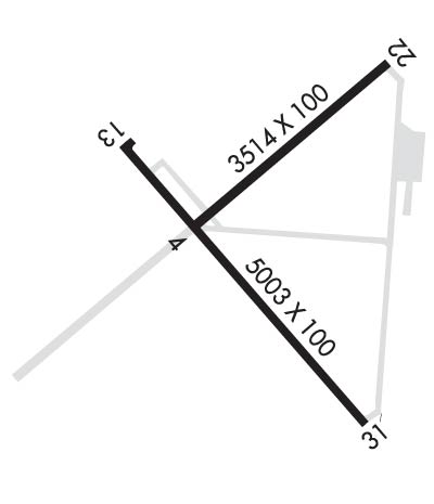
| Lat: N 3146.8 Long: W 10312.1 Elev: 2822 Var: -08 Longest Runway: 5003 | ||
| AWOS: 118.32 CTAF: 123.0 | ||
| ||||||||||||||||||||||||||||||||||||||||||||
| ||||||||||||||||||||||||||||||||||||||||||||
| ||||||||||||||||||||||||||||||||||||||||||||
| Rwy | Rwy | |||||||
| 3514x100 | 3514' | 3514x100 | 3514' | |||||
| 5003x100 | 5003' | 5003x100 | 5003' | |||||
| Runway ID | Single Wheel | Double Wheel | Double Tandem Wheel | Dual Double Wheel |
| 04/22 | 26,000 | 40,000 | N/A | N/A |
| 13/31 | 26,000 | 40,000 | N/A | N/A |
| These numbers are Advisory and are not limits. The Airport Manager should have more accurate Weight Limits | ||||
 Airport Diagram might not be current. | |
| Facility Name: | WINKLER COUNTY |
| City Name: | WINK |
| County: | WINKLER |
| State abbrev: | TX |
| State Name: | TEXAS |
| Ownership: | PUBLICLY OWNED |
| Use: | OPEN TO THE PUBLIC |
| Owner's Name: | WINKLER COUNTY |
| Address: | WINKLER COUNTY COURTHOUSE, P.O. DRAWER Y |
| KERMIT, TX 79745 | |
| Owner's Phone: | 432-586-6658 |
| Manager's Name: | LESLIE BULLARD |
| Address: | P.O. BOX 26 |
| KERMIT, TX 79745 | |
| Phone: | (432) 294-4247 |
| FAA Region: | SOUTHWEST |
| FAA Field Office: | TEX |
| Date | Sunrise | Sunset |
|---|---|---|
| 09/24/21 Friday | 7:42 | 19:47 |
| 09/25/21 Saturday | 7:43 | 19:46 |
| 09/26/21 Sunday | 7:43 | 19:44 |
| 09/27/21 Monday | 7:44 | 19:43 |
| 09/28/21 Tuesday | 7:45 | 19:42 |
| 09/29/21 Wednesday | 7:45 | 19:41 |
| 09/30/21 Thursday | 7:46 | 19:39 |
| 10/01/21 Friday | 7:47 | 19:38 |
| 10/02/21 Saturday | 7:47 | 19:37 |
| 10/03/21 Sunday | 7:48 | 19:35 |
| 10/04/21 Monday | 7:48 | 19:34 |
| 10/05/21 Tuesday | 7:49 | 19:33 |
| 10/06/21 Wednesday | 7:50 | 19:32 |
| 10/07/21 Thursday | 7:50 | 19:30 |
| Airport Attendance Schedule | MON-SAT 0800-1800 |
| Airport Status | OPERATIONAL (This Status can change at any time - please check NOTAMS) |
| Airport Lighting Schedule | MIRL RWYS 04/22 & 13/31 PRESET LOW INTST; TO INCR INTST & ACTVT PAPI RWY 13 - CTAF. |
| Airport Storage Available | Tie Downs, Hanger |
| Extra Services Available | NONE |
| Wind Indicator | YES - (lighted) |
| Control Tower | NO |
| CTAF Frequency | 123.000 |
| Unicom Frequency | 123.000 |
| Rotating Beacon Color | CLEAR-GREEN (Light Land Airport) |
| Segmented Circle | YES |
| Landing Fee | NO |
| Airport Inspected | STATE - performed by PRIVATE CONTRACT PERSONNEL |
| Inspection Date | 05/20/2021 |
| Type of Fuel Available | Grade 100LL, JET A; -10FUEL AVBL 24 HRS SELF SERVE OR FULL SERVICE. |
| Airframe Repair Service | NONE |
| Power Plant Repair Service | NONE |
| Latitude | N3146.8 |
| Longitude | W10312.1 (ESTIMATED) |
| Arpt Elevation | 2821ft (SURVEYED) |
| Magnetic Variation | 08E |
| 3 miles NW | of WINK |
| Traffic Pattern Altitude | |
| Sectional Chart | EL PASO |
| Operations (Reported) | Yearly | Avg. Daily |
|---|---|---|
| General Aviation Transient | 2200 | 6 |
| General Aviation Local | 520 | 1 |
| Air Taxi | 0 | 0 |
| Commerical | 0 | 0 |
| Commuter | 0 | 0 |
| Military | 0 | 0 |
| Aircraft based on Field | |
|---|---|
| General Aviation Singles | 13 |
| General Aviation Multi | 0 |
| Jet Aircraft | 0 |
| General Aviation Helicopters | 1 |
| Military Aircraft | 0 |
| Gliders | 0 |
| Ultralights | 0 |
| FSS on field | NO |
| FSS tie-in | SAN ANGELO |
| FSS Phone | 1-800-WX-BRIEF |
| Who issues Notams | INK |
| Notam D service at airport | YES |
| ARTCC Name | FORT WORTH |
| Airport Certification | |
| Aircraft Rescue & Firefighting Index | None |
| Airport of Entry | No |
| Custom Landing Rights | No |
| Joint Civil/Military | No |
| Military Landing rights | YES |
| NATIONAL PLAN OF INTEGRATED AIRPORT SYSTEMS (NPIAS) |
| GRANT AGREEMENT HAS EXPIRED; HOWEVER, AGREEMENT REMAINS IN EFFECT FOR THIS FACILITY AS LONG AS IT IS PUBLIC USE. |
| AGREEMENT UNDER DLAND OR DCLA HAS EXPIRED. |
| THIS AIRPORT HAS BEEN SURVEYED BY THE NATIONAL GEODETIC SURVEY. |
| FOR CD IF UNA TO CTC ON FSS FREQ, CTC FORT WORTH ARTCC AT 817-858-7584. |
Airport Communications & Frequencies:
| |||||||||
| Runway: 04 | Runway: 22 | ||
| Mag heading: | 42° | Mag heading: | 222° |
| Rwy Slope: | -.20% Down | Rwy Slope: | .20% Up |
| Approach: | Approach: | ||
| Pattern: | Left Traffic | Pattern: | Left Traffic |
| Markings: | BASIC | Markings: | BASIC |
| Marking Condition: | GOOD | Marking Condition: | GOOD |
| Arresting Dev: | Arresting Dev: | ||
| Lat & Long: | N3146.8 W10312.3 | Lat. & Long.: | N3147.1 W10311.8 |
| Elev: | 2817.6 ft. MSL | Elev: | 2810.5 ft. MSL |
| TCH: | TCH: | ||
| Visual Glide Path: | Visual Glide Path: | ||
| Displaced Threshold: | No | Displaced Threshold: | No |
| Touchdown Zone: | YES | Touchdown Zone: | YES |
| Touchdown Elev.: | 2817.8 feet | Touchdown Elev.: | 2816.1 feet |
| Visual Glide Slope: | Visual Glide Slope: | ||
| RVR Equipment: | RVR Equipment: | ||
| RVV Equipment: | NO | RVV Equipment: | NO |
| Approach Lights: | Approach Lights: | ||
| REIL: | NO | REIL: | NO |
| Centerline Lights: | NO | Centerline Lights: | NO |
| Touchdown lights: | NO | Touchdown lights: | NO |
| Runway Category: | Runway with a Visual Approach | Runway Category: | Runway with a Visual Approach |
| Declared Distances: | Declared Distances: | ||
| Obstructions: | BRUSH | Obstructions: | PLINE |
| Marked: | NOT Marked/Lighted | Marked: | MARKED |
| Clearance slope: | Clearance slope: | 30:1 | |
| Obstruction height: | 8 feet AGL | Obstruction height: | 23 feet AGL |
| Dist. from runway: | 200 feet | Dist. from runway: | 900 feet |
| Centerline offset: | 39 right of centerline | Centerline offset: | 130 feet left of centerline |
| Comments: | Comments: | + 6 FT SCATTERED BRUSH FM THR TO 200 FT FM THR, 115 FT R. |
| Runway: 13 | Runway: 31 | ||
| Mag heading: | 132° | Mag heading: | 312° |
| Rwy Slope: | -.20% Down | Rwy Slope: | .20% Up |
| Approach: | Approach: | ||
| Pattern: | Left Traffic | Pattern: | Left Traffic |
| Markings: | NONPRECISION INSTRUMENT | Markings: | NONPRECISION INSTRUMENT |
| Marking Condition: | GOOD | Marking Condition: | GOOD |
| Arresting Dev: | Arresting Dev: | ||
| Lat & Long: | N3147.0 W10312.5 | Lat. & Long.: | N3146.3 W10311.9 |
| Elev: | 2821.6 ft. MSL | Elev: | 2811.8 ft. MSL |
| TCH: | 22 ft. AGL | TCH: | |
| Visual Glide Path: | 3.00 degrees | Visual Glide Path: | |
| Displaced Threshold: | No | Displaced Threshold: | No |
| Touchdown Zone: | YES | Touchdown Zone: | YES |
| Touchdown Elev.: | 2821.6 feet | Touchdown Elev.: | 2817.6 feet |
| Visual Glide Slope: | 2-Light PAPI on LEFT side of Runway | Visual Glide Slope: | |
| RVR Equipment: | RVR Equipment: | ||
| RVV Equipment: | NO | RVV Equipment: | NO |
| Approach Lights: | Approach Lights: | ||
| REIL: | NO | REIL: | NO |
| Centerline Lights: | NO | Centerline Lights: | NO |
| Touchdown lights: | NO | Touchdown lights: | NO |
| Runway Category: | D | Runway Category: | D |
| Declared Distances: | Declared Distances: | ||
| Obstructions: | BRUSH | Obstructions: | BRUSH |
| Marked: | NOT Marked/Lighted | Marked: | NOT Marked/Lighted |
| Clearance slope: | Clearance slope: | ||
| Obstruction height: | 5 feet AGL | Obstruction height: | 8 feet AGL |
| Dist. from runway: | 200 feet | Dist. from runway: | 200 feet |
| Centerline offset: | 244 right of centerline | Centerline offset: | 285 feet left of centerline |
| Comments: | + 6 FT SCATTERED BRUSH FM THR TO 200 FT FM THR, 243 FT R AND 258 FT L. | Comments: | + 6 FT BRUSH FM THR TO 200 FT FM THR, 354 FT R AND 248 FT L. |
Thanks for using FltPlan.com
all rights reserved © 1999-2021 by Flight Plan LLC
