
| HILLSBORO MUNI HILLSBORO TX |
| |
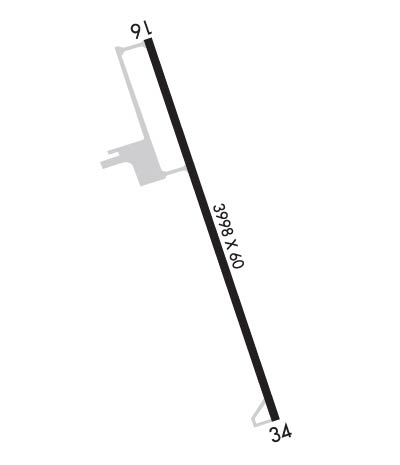
| Lat: N 3205.0 Long: W 09705.8 Elev: 686 Var: -06 Longest Runway: 3998 | ||
| AWOS: 118.72 CTAF: 122.9 | ||
| ||||||||||||||||||||||||||||||||||||||||||||
| ||||||||||||||||||||||||||||||||||||||||||||
| ||||||||||||||||||||||||||||||||||||||||||||
| Rwy | Rwy | |||||||
| 3998x60 | 3998' | 3998x60 | 3998' | |||||
| Runway ID | Single Wheel | Double Wheel | Double Tandem Wheel | Dual Double Wheel |
| 16/34 | 12,500 | N/A | N/A | N/A |
| These numbers are Advisory and are not limits. The Airport Manager should have more accurate Weight Limits | ||||
 Airport Diagram might not be current. | |
| Facility Name: | HILLSBORO MUNI |
| City Name: | HILLSBORO |
| County: | HILL |
| State abbrev: | TX |
| State Name: | TEXAS |
| Ownership: | PUBLICLY OWNED |
| Use: | OPEN TO THE PUBLIC |
| Owner's Name: | CITY OF HILLSBORO |
| Address: | PO BOX 568 |
| HILLSBORO, TX 76645 | |
| Owner's Phone: | 254-582-3271 |
| Manager's Name: | JOHN GRAHAM |
| Address: | 1000 AIRPORT BLVD, SUITE 101 |
| HILLSBORO, TX 76645 | |
| Phone: | 254-582-3731 |
| FAA Region: | SOUTHWEST |
| FAA Field Office: | TEX |
| Date | Sunrise | Sunset |
|---|---|---|
| 09/24/21 Friday | 7:18 | 19:23 |
| 09/25/21 Saturday | 7:18 | 19:21 |
| 09/26/21 Sunday | 7:19 | 19:20 |
| 09/27/21 Monday | 7:20 | 19:19 |
| 09/28/21 Tuesday | 7:20 | 19:17 |
| 09/29/21 Wednesday | 7:21 | 19:16 |
| 09/30/21 Thursday | 7:22 | 19:15 |
| 10/01/21 Friday | 7:22 | 19:13 |
| 10/02/21 Saturday | 7:23 | 19:12 |
| 10/03/21 Sunday | 7:23 | 19:11 |
| 10/04/21 Monday | 7:24 | 19:10 |
| 10/05/21 Tuesday | 7:25 | 19:08 |
| 10/06/21 Wednesday | 7:25 | 19:07 |
| 10/07/21 Thursday | 7:26 | 19:06 |
| Airport Attendance Schedule | MON-FRI 0800-1700 |
| Airport Status | OPERATIONAL (This Status can change at any time - please check NOTAMS) |
| Airport Lighting Schedule | SS-SR MIRL RWY 16/34 PRESET LOW INTST; TO INCR INTST - CTAF. PAPI RWY 16 OPR CONSLY. |
| Airport Storage Available | Tie Downs, Hanger |
| Extra Services Available | Crop Dusting, Flight Instruction, Parachute Jumping |
| Wind Indicator | YES - (lighted) |
| Control Tower | NO |
| CTAF Frequency | 122.900 |
| Unicom Frequency | |
| Rotating Beacon Color | CLEAR-GREEN (Light Land Airport) |
| Segmented Circle | YES |
| Landing Fee |
| Airport Inspected | STATE - performed by PRIVATE CONTRACT PERSONNEL |
| Inspection Date | 04/15/2019 |
| Type of Fuel Available | Grade 100LL, JET A (freeze point -40C); -10FOR FUEL AFT HRS CALL 254-582-8604. SELF SERVE AVBL WITH CREDIT CARD. |
| Airframe Repair Service | MAJOR |
| Power Plant Repair Service | MAJOR |
| Latitude | N3205.0 |
| Longitude | W09705.8 (ESTIMATED) |
| Arpt Elevation | 685ft (SURVEYED) |
| Magnetic Variation | 06E |
| 5 miles N | of HILLSBORO |
| Traffic Pattern Altitude | |
| Sectional Chart | DALLAS-FT WORTH |
| Operations (Reported) | Yearly | Avg. Daily |
|---|---|---|
| General Aviation Transient | 2700 | 7 |
| General Aviation Local | 8100 | 22 |
| Air Taxi | 0 | 0 |
| Commerical | 0 | 0 |
| Commuter | 0 | 0 |
| Military | 0 | 0 |
| Aircraft based on Field | |
|---|---|
| General Aviation Singles | 20 |
| General Aviation Multi | 3 |
| Jet Aircraft | 0 |
| General Aviation Helicopters | 1 |
| Military Aircraft | 0 |
| Gliders | 0 |
| Ultralights | 0 |
| FSS on field | NO |
| FSS tie-in | FORT WORTH |
| FSS Phone | 1-800-WX-BRIEF |
| Who issues Notams | INJ |
| Notam D service at airport | YES |
| ARTCC Name | FORT WORTH |
| Airport Certification | |
| Aircraft Rescue & Firefighting Index | None |
| Airport of Entry | No |
| Custom Landing Rights | No |
| Joint Civil/Military | No |
| Military Landing rights | No |
| NATIONAL PLAN OF INTEGRATED AIRPORT SYSTEMS (NPIAS) |
| GRANT AGREEMENTS UNDER FAAP/ADAP/AIP |
| ASSURANCES PURSUANT TO TITLE VI, CIVIL RIGHTS ACT OF 1964 |
| NOISE SENSITIVE AREA: EXTEND PATTERN ON TKOF AND LNDG RY 16 TO AVOID FLYING OVER HOUSES TO THE SE & EAST SIDE OF ARPT. |
| SKYDIVING ACTIVITY INVOF ARPT. |
| FOR CD CTC FORT WORTH ARTCC AT 817-858-7584. |
Airport Communications & Frequencies:
| |||||||||||||||
| Runway: 16 | Runway: 34 | ||
| Mag heading: | 156° | Mag heading: | 336° |
| Rwy Slope: | -.26% Down | Rwy Slope: | .26% Up |
| Approach: | Approach: | ||
| Pattern: | Left Traffic | Pattern: | Left Traffic |
| Markings: | NONPRECISION INSTRUMENT | Markings: | NONPRECISION INSTRUMENT |
| Marking Condition: | GOOD | Marking Condition: | GOOD |
| Arresting Dev: | Arresting Dev: | ||
| Lat & Long: | N3205.3 W09706.0 | Lat. & Long.: | N3204.7 W09705.7 |
| Elev: | 685.7 ft. MSL | Elev: | 675.5 ft. MSL |
| TCH: | 24 ft. AGL | TCH: | |
| Visual Glide Path: | 3.50 degrees | Visual Glide Path: | |
| Displaced Threshold: | No | Displaced Threshold: | No |
| Touchdown Zone: | YES | Touchdown Zone: | YES |
| Touchdown Elev.: | 685.7 feet | Touchdown Elev.: | 683.5 feet |
| Visual Glide Slope: | 2-Light PAPI on LEFT side of Runway | Visual Glide Slope: | |
| RVR Equipment: | RVR Equipment: | ||
| RVV Equipment: | NO | RVV Equipment: | NO |
| Approach Lights: | Approach Lights: | ||
| REIL: | NO | REIL: | NO |
| Centerline Lights: | NO | Centerline Lights: | NO |
| Touchdown lights: | NO | Touchdown lights: | NO |
| Runway Category: | Runway with a Non-precision Approach | Runway Category: | Runway with a Non-precision Approach |
| Declared Distances: | Declared Distances: |
Thanks for using FltPlan.com
all rights reserved © 1999-2021 by Flight Plan LLC
