| FORD IRON MNTN KINGSFORD MI |
| |
| Lat: N 4549.1 Long: W 08806.9 Elev: 1182 Var: +02 Longest Runway: 6502 | ||
| AWOS: 119.02 CTAF: 122.8 | ||
| |||||||||||||||||||||||||||||||||||||||||||||||||||||||||||||||||||||
| |||||||||||||||||||||||||||||||||||||||||||||||||||||||||||||||||||||
| |||||||||||||||||||||||||||||||||||||||||||||||||||||||||||||||||||||
| |||||||||||||||||||||||||||||||||||||||||||||||||||||||||||||||||||||
| Rwy | Rwy | |||||||
| 6502x150 | 6502' | 111.50 - 009° | 6502x150 | 6502' | ||||
| 3810x75 | 3810' | 3810x75 | 3810' | |||||
| Runway ID | Single Wheel | Double Wheel | Double Tandem Wheel | Dual Double Wheel |
| 01/19 | 100,000 | 100,000 | 190,000 | N/A |
| 13/31 | 30,000 | 50,000 | 80,000 | N/A |
| These numbers are Advisory and are not limits. The Airport Manager should have more accurate Weight Limits | ||||
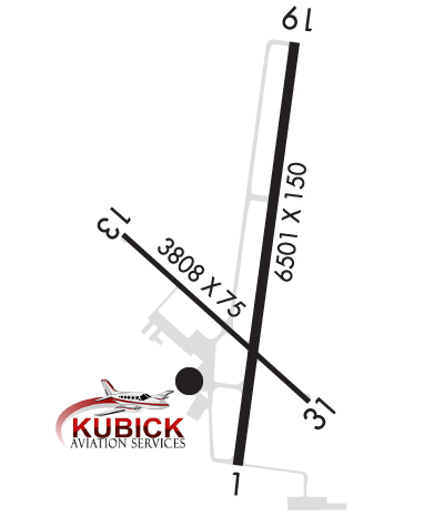 Airport Diagram might not be current. | |
| Facility Name: | FORD |
| City Name: | IRON MOUNTAIN KINGSFORD |
| County: | DICKINSON |
| State abbrev: | MI |
| State Name: | MICHIGAN |
| Ownership: | PUBLICLY OWNED |
| Use: | OPEN TO THE PUBLIC |
| Owner's Name: | DICKINSON COUNTY |
| Address: | COUNTY COURT HOUSE |
| IRON MOUNTAIN, MI 49802 | |
| Owner's Phone: | 906-774-2573 |
| Manager's Name: | TIM HOWEN |
| Address: | FORD ARPT |
| KINGSFORD, MI 49801 | |
| Phone: | 906-774-4870; CELL 906-201-1866. |
| FAA Region: | GREAT LAKES |
| FAA Field Office: | DET |

| Date | Sunrise | Sunset |
|---|---|---|
| 06/07/26 Sunday | 5:03 | 20:40 |
| 06/08/26 Monday | 5:03 | 20:40 |
| 06/09/26 Tuesday | 5:03 | 20:41 |
| 06/10/26 Wednesday | 5:02 | 20:42 |
| 06/11/26 Thursday | 5:02 | 20:42 |
| 06/12/26 Friday | 5:02 | 20:43 |
| 06/13/26 Saturday | 5:02 | 20:43 |
| 06/14/26 Sunday | 5:02 | 20:44 |
| 06/15/26 Monday | 5:02 | 20:44 |
| 06/16/26 Tuesday | 5:02 | 20:45 |
| 06/17/26 Wednesday | 5:02 | 20:45 |
| 06/18/26 Thursday | 5:02 | 20:45 |
| 06/19/26 Friday | 5:02 | 20:46 |
| 06/20/26 Saturday | 5:02 | 20:46 |
| Airport Attendance Schedule | 7 Days A Week 0600-2100 |
| Airport Status | OPERATIONAL (This Status can change at any time - please check NOTAMS) |
| Airport Lighting Schedule | ACTVT MALSR RWY 01; REIL RWY 19 & 31; PAPI RWY 19 & 31; HIRL RWY 01/19; MIRL RWY 13/31 - CTAF. |
| Airport Storage Available | Tie Downs, Hanger |
| Extra Services Available | Air Freight, Charter, Flight Instruction, Aircraft Rental |
| Wind Indicator | YES - (lighted) |
| Control Tower | NO |
| CTAF Frequency | 122.800 |
| Unicom Frequency | 122.800; UNICOM IREG MNTD. |
| Rotating Beacon Color | WG |
| Segmented Circle | NO |
| Landing Fee | YES |
| Airport Inspected | FEDERAL - performed by FAA AIRPORTS FIELD PERSONNEL |
| Inspection Date | 05/21/2025 |
| Type of Fuel Available | Grade 100LL, JET A (freeze point -40C) |
| Airframe Repair Service | MAJOR |
| Power Plant Repair Service | MAJOR |
| Latitude | N4549.1 |
| Longitude | W08806.9 (ESTIMATED) |
| Arpt Elevation | 1182ft (SURVEYED) |
| Magnetic Variation | 02W |
| 3 miles W | of IRON MOUNTAIN KINGSFORD |
| Traffic Pattern Altitude | 800; TPA FOR JET/TURBO-JET AND PROP ACFT OVER 12500LBS IS 1500' AGL. |
| Sectional Chart | GREEN BAY |
| Operations (Reported) | Yearly | Avg. Daily |
|---|---|---|
| General Aviation Transient | 0 | 0 |
| General Aviation Local | 0 | 0 |
| Air Taxi | 0 | 0 |
| Commerical | 0 | 0 |
| Commuter | 0 | 0 |
| Military | 0 | 0 |
| Aircraft based on Field | |
|---|---|
| General Aviation Singles | 0 |
| General Aviation Multi | 0 |
| Jet Aircraft | 0 |
| General Aviation Helicopters | 0 |
| Military Aircraft | 0 |
| Gliders | 0 |
| Ultralights | 0 |
| FSS on field | NO |
| FSS tie-in | GREEN BAY |
| FSS Phone | 1-800-WX-BRIEF |
| Who issues Notams | IMT |
| Notam D service at airport | YES |
| ARTCC Name | MINNEAPOLIS |
| Airport Certification | AIRPORT RECEIVING SCHEDULED AIR CARRIER SERVICE FROM CARRIERS CERTIFICATED BY THE CIVIL AERONAUTICS BOARD; ACR OPS GTR THAN 9 PAX SEATS NA IF NOT WI 15 MINS OF SKEDD ARR/DEP TIME EXC BY PRIOR CDN WITH AMGR & CFMN ARFF IS AVBL PRIOR TO TKOF/LDG. |
| Aircraft Rescue & Firefighting Index | AIRPORT HAS A CERTIFICATE UNDER CFR PART 139 |
| Airport of Entry | No |
| Custom Landing Rights | No |
| Joint Civil/Military | No |
| Military Landing rights | YES |
| NATIONAL PLAN OF INTEGRATED AIRPORT SYSTEMS (NPIAS) |
| GRANT AGREEMENTS UNDER FAAP/ADAP/AIP |
| ASSURANCES PURSUANT TO TITLE VI, CIVIL RIGHTS ACT OF 1964 |
| DEER, COYOTES, & BIRDS ON & INVOF ARPT. |
| 48 HRS PPR FOR UNSKED ACR OPS GTR THAN 30 PAX SEATS - CALL AMGR CELL. |
| ARFF CREWS MNT CTAF/UNICOM DRG ALL ACR OPS. |
| SNOW REMOVAL CREWS MNT CTAF/UNICOM DRG ALL ACR OPS TO PRVD SFC COND RPRTS. |
| FLD CONDS UNMON OCT 15 THRU APR 1 BTN 2100-0600. |
| RWY 13/3 1 RWY 13/31 NOT AVBL FOR PART 121/PART 380 OPS WITH SKED PAX CARRYING OPS MORE THAN 9 PAX SEATS AND NON-SKED PAX CARRYING OPS MORE THAN 30 PAX SEATS. |
| RWY 01/1 9 PCR VALUE: 159/F/B/X/T |
| RWY 13/3 1 PCR VALUE: 99/F/B/X/T |
Airport Communications & Frequencies:
| |||||||||
| Runway: 01 | Runway: 19 | ||
| Mag heading: | 10° | Mag heading: | 190° |
| Rwy Slope: | .77% Up | Rwy Slope: | -.77% Down |
| Approach: | ILS | Approach: | |
| Pattern: | Left Traffic | Pattern: | Left Traffic |
| Markings: | PRECISION INSTRUMENT | Markings: | PRECISION INSTRUMENT |
| Marking Condition: | GOOD | Marking Condition: | GOOD |
| Arresting Dev: | Arresting Dev: | ||
| Lat & Long: | N4548.6 W08806.9 | Lat. & Long.: | N4549.7 W08806.7 |
| Elev: | 1132.0 ft. MSL | Elev: | 1182.0 ft. MSL |
| TCH: | TCH: | 42 ft. AGL | |
| Visual Glide Path: | Visual Glide Path: | 3.00 degrees | |
| Displaced Threshold: | No | Displaced Threshold: | No |
| Touchdown Zone: | YES | Touchdown Zone: | YES |
| Touchdown Elev.: | 1132.8 feet | Touchdown Elev.: | 1182.0 feet |
| Visual Glide Slope: | Visual Glide Slope: | 4-Light PAPI on LEFT side of Runway | |
| RVR Equipment: | RVR Equipment: | ||
| RVV Equipment: | NO | RVV Equipment: | NO |
| Approach Lights: | MALSR - 1,400 foot medium intensity approach lighting system with runway alignment indicator lights | Approach Lights: | |
| REIL: | NO | REIL: | YES |
| Centerline Lights: | NO | Centerline Lights: | NO |
| Touchdown lights: | NO | Touchdown lights: | NO |
| Runway Category: | Precision Instrument Runway | Runway Category: | Runway with a Non-precision Approach having visibility minimums greater than 3/4 mile |
| Declared Distances: | TORA:6502' TODA:6502' ASDA:6502' LDA:6502' | Declared Distances: | TORA:6502' TODA:6502' ASDA:6376' LDA:6376' |
| Runway: 13 | Runway: 31 | ||
| Mag heading: | 134° | Mag heading: | 314° |
| Rwy Slope: | -.10% Down | Rwy Slope: | .10% Up |
| Approach: | Approach: | ||
| Pattern: | Left Traffic | Pattern: | Left Traffic |
| Markings: | NONPRECISION INSTRUMENT | Markings: | NONPRECISION INSTRUMENT |
| Marking Condition: | FAIR | Marking Condition: | FAIR |
| Arresting Dev: | Arresting Dev: | ||
| Lat & Long: | N4549.2 W08807.3 | Lat. & Long.: | N4548.8 W08806.7 |
| Elev: | 1128.6 ft. MSL | Elev: | 1124.8 ft. MSL |
| TCH: | TCH: | 40 ft. AGL | |
| Visual Glide Path: | Visual Glide Path: | 4.00 degrees | |
| Displaced Threshold: | No | Displaced Threshold: | No |
| Touchdown Zone: | YES | Touchdown Zone: | YES |
| Touchdown Elev.: | 1130.9 feet | Touchdown Elev.: | 1130.9 feet |
| Visual Glide Slope: | Visual Glide Slope: | 4-Light PAPI on LEFT side of Runway | |
| RVR Equipment: | RVR Equipment: | ||
| RVV Equipment: | NO | RVV Equipment: | NO |
| Approach Lights: | Approach Lights: | ||
| REIL: | NO | REIL: | YES |
| Centerline Lights: | NO | Centerline Lights: | NO |
| Touchdown lights: | NO | Touchdown lights: | NO |
| Runway Category: | Runway with a Non-precision Approach | Runway Category: | Runway with a Non-precision Approach |
| Declared Distances: | TORA:3810' TODA:3810' ASDA:3810' LDA:3810' | Declared Distances: | TORA:3810' TODA:3810' ASDA:3810' LDA:3810' |
Thanks for using FltPlan.com
all rights reserved © 1999-2026 by Flight Plan LLC