
| MADISON MUNI MADISON IN |
| |
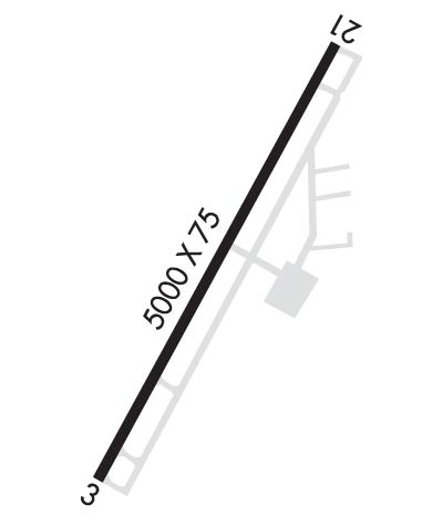
| Lat: N 3845.6 Long: W 08527.9 Elev: 819 Var: +03 Longest Runway: 5000 | ||
| AWOS: 119.17 CTAF: 123.0 | ||
| ||||||||||||||||||||||||||||||||||||||||||||
| ||||||||||||||||||||||||||||||||||||||||||||
| ||||||||||||||||||||||||||||||||||||||||||||
| Rwy | Rwy | |||||||
| 5000x75 | 5000' | 5000x75 | 5000' | |||||
| Runway ID | Single Wheel | Double Wheel | Double Tandem Wheel | Dual Double Wheel |
| 03/21 | 61,000 | 82,000 | N/A | N/A |
| These numbers are Advisory and are not limits. The Airport Manager should have more accurate Weight Limits | ||||
 Airport Diagram might not be current. | |
| Facility Name: | MADISON RGNL |
| City Name: | MADISON |
| County: | JEFFERSON |
| State abbrev: | IN |
| State Name: | INDIANA |
| Ownership: | PUBLICLY OWNED |
| Use: | OPEN TO THE PUBLIC |
| Owner's Name: | MADISON BOAC |
| Address: | 101 W. MAIN ST. |
| MADISON, IN 47250 | |
| Owner's Phone: | 812-273-1914 |
| Manager's Name: | BRENT SPRY |
| Address: | 3919 W. IMS LANE |
| MADISON, IN 47250 | |
| Phone: | 812-273-1914 |
| FAA Region: | GREAT LAKES |
| FAA Field Office: | CHI |

| Date | Sunrise | Sunset |
|---|---|---|
| 06/08/26 Monday | 6:17 | 21:05 |
| 06/09/26 Tuesday | 6:17 | 21:06 |
| 06/10/26 Wednesday | 6:17 | 21:06 |
| 06/11/26 Thursday | 6:16 | 21:07 |
| 06/12/26 Friday | 6:16 | 21:07 |
| 06/13/26 Saturday | 6:16 | 21:08 |
| 06/14/26 Sunday | 6:16 | 21:08 |
| 06/15/26 Monday | 6:16 | 21:08 |
| 06/16/26 Tuesday | 6:16 | 21:09 |
| 06/17/26 Wednesday | 6:16 | 21:09 |
| 06/18/26 Thursday | 6:17 | 21:09 |
| 06/19/26 Friday | 6:17 | 21:10 |
| 06/20/26 Saturday | 6:17 | 21:10 |
| 06/21/26 Sunday | 6:17 | 21:10 |
| Airport Attendance Schedule | MAR-OCT 7 Days A Week 0800-1800, NOV-FEB 7 Days A Week 0800-1700; UNATNDD THANKSGIVING, CHRISTMAS & NEW YEARS. |
| Airport Status | OPERATIONAL (This Status can change at any time - please check NOTAMS) |
| Airport Lighting Schedule | ACTVT MALSF RWY 03; REIL RWY 21; PAPI RWY 03 & 21; HIRL RWY 03/21 - CTAF. |
| Airport Storage Available | Tie Downs, Hanger |
| Extra Services Available | Crop Dusting, Air Ambulance, Flight Instruction, Aircraft Rental |
| Wind Indicator | YES - (lighted) |
| Control Tower | NO |
| CTAF Frequency | 123.000 |
| Unicom Frequency | 123.000 |
| Rotating Beacon Color | WG |
| Segmented Circle | NO |
| Landing Fee | NO |
| Airport Inspected | STATE - performed by STATE AERONAUTICAL PERSONNEL |
| Inspection Date | 02/10/2025 |
| Type of Fuel Available | Grade 100LL, JET A (freeze point -40C); -10SELF SERVE AVBL. |
| Airframe Repair Service | MAJOR |
| Power Plant Repair Service | MAJOR |
| Latitude | N3845.6 |
| Longitude | W08527.9 (ESTIMATED) |
| Arpt Elevation | 819ft (SURVEYED) |
| Magnetic Variation | 03W |
| 4 miles W | of MADISON |
| Traffic Pattern Altitude | |
| Sectional Chart | ST LOUIS |
| Operations (Reported) | Yearly | Avg. Daily |
|---|---|---|
| General Aviation Transient | 0 | 0 |
| General Aviation Local | 0 | 0 |
| Air Taxi | 0 | 0 |
| Commerical | 0 | 0 |
| Commuter | 0 | 0 |
| Military | 0 | 0 |
| Aircraft based on Field | |
|---|---|
| General Aviation Singles | 0 |
| General Aviation Multi | 0 |
| Jet Aircraft | 0 |
| General Aviation Helicopters | 0 |
| Military Aircraft | 0 |
| Gliders | 0 |
| Ultralights | 0 |
| FSS on field | NO |
| FSS tie-in | TERRE HAUTE |
| FSS Phone | 1-800-WX-BRIEF |
| Who issues Notams | HUF |
| Notam D service at airport | YES |
| ARTCC Name | INDIANAPOLIS |
| Airport Certification | |
| Aircraft Rescue & Firefighting Index | None |
| Airport of Entry | No |
| Custom Landing Rights | No |
| Joint Civil/Military | No |
| Military Landing rights | YES |
| NATIONAL PLAN OF INTEGRATED AIRPORT SYSTEMS (NPIAS) |
| GRANT AGREEMENTS UNDER FAAP/ADAP/AIP |
| ASSURANCES PURSUANT TO TITLE VI, CIVIL RIGHTS ACT OF 1964 |
| THIS AIRPORT HAS BEEN SURVEYED BY THE NATIONAL GEODETIC SURVEY. |
| FOR CD CTC LOUISVILLE APCH AT 502-375-7499 |
Airport Communications & Frequencies:
| ||||||||||||||
| Runway: 03 | Runway: 21 | ||
| Mag heading: | 35° | Mag heading: | 215° |
| Rwy Slope: | .24% Up | Rwy Slope: | -.24% Down |
| Approach: | Approach: | ||
| Pattern: | Left Traffic | Pattern: | Left Traffic |
| Markings: | NONPRECISION INSTRUMENT | Markings: | NONPRECISION INSTRUMENT |
| Marking Condition: | GOOD | Marking Condition: | GOOD |
| Arresting Dev: | Arresting Dev: | ||
| Lat & Long: | N3845.2 W08528.2 | Lat. & Long.: | N3845.9 W08527.6 |
| Elev: | 807.2 ft. MSL | Elev: | 819.1 ft. MSL |
| TCH: | 42 ft. AGL | TCH: | 39 ft. AGL |
| Visual Glide Path: | 3.50 degrees | Visual Glide Path: | 3.00 degrees |
| Displaced Threshold: | No | Displaced Threshold: | No |
| Touchdown Zone: | YES | Touchdown Zone: | YES |
| Touchdown Elev.: | 812.4 feet | Touchdown Elev.: | 819.1 feet |
| Visual Glide Slope: | 4-Light PAPI on LEFT side of Runway | Visual Glide Slope: | 2-Light PAPI on LEFT side of Runway |
| RVR Equipment: | RVR Equipment: | ||
| RVV Equipment: | NO | RVV Equipment: | NO |
| Approach Lights: | MALSF - 1,400 foot medium intensity approach lighting system with sequenced flashers | Approach Lights: | |
| REIL: | NO | REIL: | YES |
| Centerline Lights: | NO | Centerline Lights: | NO |
| Touchdown lights: | NO | Touchdown lights: | NO |
| Runway Category: | Runway with a Non-precision Approach | Runway Category: | Runway with a Visual Approach |
| Declared Distances: | Declared Distances: | ||
| Obstructions: | TREES | Obstructions: | CROPS |
| Marked: | LIGHTED | Marked: | NOT Marked/Lighted |
| Clearance slope: | 20:1 | Clearance slope: | 20:1 |
| Obstruction height: | 80 feet AGL | Obstruction height: | 10 feet AGL |
| Dist. from runway: | 1850 feet | Dist. from runway: | 201 feet |
| Centerline offset: | 435 right of centerline | Centerline offset: | |
| Comments: | Comments: |
Thanks for using FltPlan.com
all rights reserved © 1999-2026 by Flight Plan LLC