
| WILMINGTON AIR PARK WILMINGTON OH |
| |
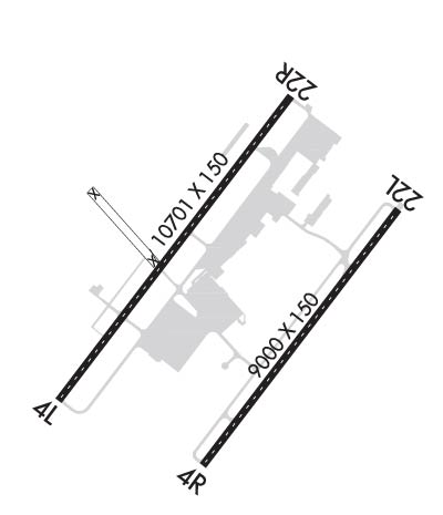
| Lat: N 3925.7 Long: W 08347.5 Elev: 1077 Var: +07 Longest Runway: 10701 | ||
| Clr Del: 128.85 Dept. ATIS: 124.92 Arr. ATIS: 124.92 AWOS: 124.92 Ground: 121.6 Tower: 119.47 | ||
| ||||||||||||||||||||||||||||||||||||||||||||
| ||||||||||||||||||||||||||||||||||||||||||||
| ||||||||||||||||||||||||||||||||||||||||||||
| Rwy | Rwy | |||||||
| 10701x150 | 10701' | 110.70 - 044° | 10701x150 | 10701' | 110.70 - 224° | |||
| 9000x150 | 9000' | 109.35 - 044° | 9000x150 | 9000' | 109.35 - 224° | |||
| Runway ID | Single Wheel | Double Wheel | Double Tandem Wheel | Dual Double Wheel |
| 04L/22R | 100,000 | 200,000 | 390,000 | 750,000 |
| 04R/22L | 100,000 | 200,000 | 390,000 | 750,000 |
| These numbers are Advisory and are not limits. The Airport Manager should have more accurate Weight Limits | ||||
 Airport Diagram might not be current. | |
| Facility Name: | WILMINGTON AIR PARK |
| City Name: | WILMINGTON |
| County: | CLINTON |
| State abbrev: | OH |
| State Name: | OHIO |
| Ownership: | PUBLICLY OWNED |
| Use: | OPEN TO THE PUBLIC |
| Owner's Name: | CLINTON COUNTY PORT AUTHORITY |
| Address: | 1113 AIRPORT RD |
| WILMINGTON, OH 45177-8904 | |
| Owner's Phone: | 937-536-1776 |
| Manager's Name: | JEREMY HEARD |
| Address: | 145 HUNTER DR |
| WILMINGTON, OH 45177-9550 | |
| Phone: | 937-366-2114 |
| FAA Region: | GREAT LAKES |
| FAA Field Office: | DET |
| Date | Sunrise | Sunset |
|---|---|---|
| 09/24/21 Friday | 7:24 | 19:29 |
| 09/25/21 Saturday | 7:25 | 19:28 |
| 09/26/21 Sunday | 7:26 | 19:26 |
| 09/27/21 Monday | 7:27 | 19:24 |
| 09/28/21 Tuesday | 7:28 | 19:23 |
| 09/29/21 Wednesday | 7:29 | 19:21 |
| 09/30/21 Thursday | 7:30 | 19:20 |
| 10/01/21 Friday | 7:31 | 19:18 |
| 10/02/21 Saturday | 7:32 | 19:16 |
| 10/03/21 Sunday | 7:33 | 19:15 |
| 10/04/21 Monday | 7:34 | 19:13 |
| 10/05/21 Tuesday | 7:35 | 19:12 |
| 10/06/21 Wednesday | 7:36 | 19:10 |
| 10/07/21 Thursday | 7:37 | 19:09 |
| Airport Attendance Schedule | MON-FRI 0700-2300, SAT-SUN 0800-1700 |
| Airport Status | OPERATIONAL (This Status can change at any time - please check NOTAMS) |
| Airport Lighting Schedule | PAPI RWY 04L/22R OPER CONSLY FM SS - SR INCL WEEKENDS. AFT HRS ACTVT CNTRLN LGTS RWY 04L/22R; TDZL RWY 22R; HIRL RWY 04L/22R - CTAF. ALL RWY 04R/22L LGTS UNAVBL UFN. |
| Airport Storage Available | NONE |
| Extra Services Available | NONE |
| Wind Indicator | YES - (lighted) |
| Control Tower | YES |
| CTAF Frequency | 119.475 |
| Unicom Frequency | |
| Rotating Beacon Color | CLEAR-GREEN (Light Land Airport) |
| Segmented Circle | NO |
| Landing Fee | YES |
| Airport Inspected | FEDERAL - performed by FAA AIRPORTS FIELD PERSONNEL |
| Inspection Date | 03/23/2018 |
| Type of Fuel Available | JET A (freeze point -40C) |
| Airframe Repair Service | MAJOR |
| Power Plant Repair Service | MAJOR |
| Latitude | N3925.7 |
| Longitude | W08347.5 (ESTIMATED) |
| Arpt Elevation | 1076ft (SURVEYED) |
| Magnetic Variation | 07W |
| 2 miles SE | of WILMINGTON |
| Traffic Pattern Altitude | |
| Sectional Chart | CINCINNATI |
| Operations (Reported) | Yearly | Avg. Daily |
|---|---|---|
| General Aviation Transient | 0 | 0 |
| General Aviation Local | 0 | 0 |
| Air Taxi | 900 | 2 |
| Commerical | 100 | 0 |
| Commuter | 0 | 0 |
| Military | 0 | 0 |
| Aircraft based on Field | |
|---|---|
| General Aviation Singles | 0 |
| General Aviation Multi | 0 |
| Jet Aircraft | 0 |
| General Aviation Helicopters | 0 |
| Military Aircraft | 0 |
| Gliders | 0 |
| Ultralights | 0 |
| FSS on field | NO |
| FSS tie-in | DAYTON |
| FSS Phone | 1-800-WX-BRIEF |
| Who issues Notams | ILN |
| Notam D service at airport | YES |
| ARTCC Name | INDIANAPOLIS |
| Airport Certification | CLSD TO SKEDD ACR OPS WITH GTR THAN 9 PSGR SEATS. UNSKED ACR OPS GTR THAN 30 PSGR SEATS. 90-DAY PPR; ARFF INDEX B AVBL 48 HR PPR. CALL AMGR 937-366-2114. |
| Aircraft Rescue & Firefighting Index | AIRPORT HAS A CERTIFICATE UNDER CFR PART 139 |
| Airport of Entry | No |
| Custom Landing Rights | No; US CUSTOMS USER FEE ARPT. |
| Joint Civil/Military | No |
| Military Landing rights | No |
| 4 HR PPR FOR ALL TSNT ACFT CALL AMGR 937-366-2282 DRG OPER HRS. AFT HRS CALL FLT CTL 937-366-2114. |
| FOR CD CTC COLUMBUS APCH AT 614-338-8537. |
| RWY 04R/ 22LRY 04R/22L CLOSED UFN. |
| RWY 04L/ 22RHAS 1000 FT PAVED AREA ON SW END AND 200 FT PAVED AREA ON NE END. |
| RWY 04R/ 22LHAS 200 FT PAVED AREA EACH END. |
Airport Communications & Frequencies:
| |||||||||||||||||||||||||||
| Runway: 04L | Runway: 22R | ||
| Mag heading: | 44° | Mag heading: | 224° |
| Rwy Slope: | .22% Up | Rwy Slope: | -.22% Down |
| Approach: | ILS | Approach: | ILS |
| Pattern: | Left Traffic | Pattern: | Left Traffic |
| Markings: | PRECISION INSTRUMENT | Markings: | PRECISION INSTRUMENT |
| Marking Condition: | GOOD | Marking Condition: | GOOD |
| Arresting Dev: | Arresting Dev: | ||
| Lat & Long: | N3925.2 W08348.6 | Lat. & Long.: | N3926.6 W08347.2 |
| Elev: | 1053.0 ft. MSL | Elev: | 1076.7 ft. MSL |
| TCH: | 62 ft. AGL | TCH: | 71 ft. AGL |
| Visual Glide Path: | 3.00 degrees | Visual Glide Path: | 3.00 degrees |
| Displaced Threshold: | No | Displaced Threshold: | No |
| Touchdown Zone: | YES | Touchdown Zone: | YES |
| Touchdown Elev.: | 1056.6 feet | Touchdown Elev.: | 1076.7 feet |
| Visual Glide Slope: | 4-Light PAPI on LEFT side of Runway; RY 04L PAPI RESTRICTED BYD 8 DEG LEFT & RIGHT OF CNTRLN. | Visual Glide Slope: | 4-Light PAPI on LEFT side of Runway; RY 22R PAPI-4L, RESTRICTED BYD 8 DEGS LEFT AND RIGHT OF CENTERLINE. |
| RVR Equipment: | TOUCHDOWN-MIDFIELD-ROLLOUT | RVR Equipment: | TOUCHDOWN-MIDFIELD-ROLLOUT |
| RVV Equipment: | NO | RVV Equipment: | NO |
| Approach Lights: | MALSR - 1,400 foot medium intensity approach lighting system with runway alignment indicator lights | Approach Lights: | ALSF2 - standard 2,400 foot high intensity approach lighting system with sequenced flashers, Category II or III |
| REIL: | NO | REIL: | NO |
| Centerline Lights: | YES | Centerline Lights: | YES |
| Touchdown lights: | NO | Touchdown lights: | YES |
| Runway Category: | Precision Instrument Runway | Runway Category: | Precision Instrument Runway |
| Declared Distances: | TORA:10701' TODA:10701' ASDA:10701' LDA:10701' | Declared Distances: | TORA:10701' TODA:10701' ASDA:10701' LDA:10701' |
| Runway: 04R | Runway: 22L | ||
| Mag heading: | 44° | Mag heading: | 224° |
| Rwy Slope: | .38% Up | Rwy Slope: | -.38% Down |
| Approach: | ILS/DME | Approach: | ILS/DME |
| Pattern: | Left Traffic | Pattern: | Left Traffic |
| Markings: | PRECISION INSTRUMENT | Markings: | PRECISION INSTRUMENT |
| Marking Condition: | GOOD | Marking Condition: | GOOD |
| Arresting Dev: | Arresting Dev: | ||
| Lat & Long: | N3924.9 W08347.7 | Lat. & Long.: | N3926.0 W08346.5 |
| Elev: | 1042.5 ft. MSL | Elev: | 1076.5 ft. MSL |
| TCH: | 71 ft. AGL | TCH: | 71 ft. AGL |
| Visual Glide Path: | 3.00 degrees | Visual Glide Path: | 3.00 degrees |
| Displaced Threshold: | No | Displaced Threshold: | No |
| Touchdown Zone: | YES | Touchdown Zone: | YES |
| Touchdown Elev.: | 1045.5 feet | Touchdown Elev.: | 1076.5 feet |
| Visual Glide Slope: | 4-Light PAPI on LEFT side of Runway | Visual Glide Slope: | 4-Light PAPI on LEFT side of Runway |
| RVR Equipment: | TOUCHDOWN-MIDFIELD-ROLLOUT | RVR Equipment: | TOUCHDOWN-MIDFIELD-ROLLOUT |
| RVV Equipment: | NO | RVV Equipment: | NO |
| Approach Lights: | MALSR - 1,400 foot medium intensity approach lighting system with runway alignment indicator lights | Approach Lights: | ALSF2 - standard 2,400 foot high intensity approach lighting system with sequenced flashers, Category II or III |
| REIL: | NO | REIL: | NO |
| Centerline Lights: | YES | Centerline Lights: | YES |
| Touchdown lights: | NO | Touchdown lights: | YES |
| Runway Category: | Precision Instrument Runway | Runway Category: | Precision Instrument Runway |
| Declared Distances: | TORA:9000' TODA:9000' ASDA:9000' LDA:9000' | Declared Distances: | TORA:9000' TODA:9000' ASDA:9000' LDA:9000' |
Thanks for using FltPlan.com
all rights reserved © 1999-2021 by Flight Plan LLC
