
| SKYLARK FIELD KILLEEN TX |
| |
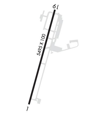
| Lat: N 3105.2 Long: W 09741.2 Elev: 848 Var: -05 Longest Runway: 5495 | ||
| Clr Del: 121.7 AWOS: 128.57 CTAF: 122.7 | ||
| ||||||
| ||||||
|
| Rwy | Rwy | |||||||
| 5495x100 | 4641' | 108.30 - 011° | 5495x100 | 5495' | ||||
| Runway ID | Single Wheel | Double Wheel | Double Tandem Wheel | Dual Double Wheel |
| 01/19 | 17,000 | 50,000 | N/A | N/A |
| These numbers are Advisory and are not limits. The Airport Manager should have more accurate Weight Limits | ||||
 Airport Diagram might not be current. | |
| Facility Name: | SKYLARK FLD |
| City Name: | KILLEEN |
| County: | BELL |
| State abbrev: | TX |
| State Name: | TEXAS |
| Ownership: | PUBLICLY OWNED |
| Use: | OPEN TO THE PUBLIC |
| Owner's Name: | CITY OF KILLEEN |
| Address: | BOX 1329 |
| KILLEEN, TX 76541 | |
| Owner's Phone: | 254-501-7600 |
| Manager's Name: | MATTHEW VAN VALKENBURGH |
| Address: | 8101 CLEAR CREEK RD., BOX C |
| KILLEEN, TX 76549 | |
| Phone: | 254-501-8700 |
| FAA Region: | SOUTHWEST |
| FAA Field Office: | TEX |
| Date | Sunrise | Sunset |
|---|---|---|
| 09/24/21 Friday | 7:20 | 19:25 |
| 09/25/21 Saturday | 7:21 | 19:24 |
| 09/26/21 Sunday | 7:21 | 19:22 |
| 09/27/21 Monday | 7:22 | 19:21 |
| 09/28/21 Tuesday | 7:22 | 19:20 |
| 09/29/21 Wednesday | 7:23 | 19:19 |
| 09/30/21 Thursday | 7:24 | 19:17 |
| 10/01/21 Friday | 7:24 | 19:16 |
| 10/02/21 Saturday | 7:25 | 19:15 |
| 10/03/21 Sunday | 7:26 | 19:14 |
| 10/04/21 Monday | 7:26 | 19:12 |
| 10/05/21 Tuesday | 7:27 | 19:11 |
| 10/06/21 Wednesday | 7:27 | 19:10 |
| 10/07/21 Thursday | 7:28 | 19:09 |
| Airport Attendance Schedule | MON-FRI 0800-1700 |
| Airport Status | OPERATIONAL (This Status can change at any time - please check NOTAMS) |
| Airport Lighting Schedule | SS-SR. MIRL RY 01/19 PRESET LOW INTST; TO INCR INTST & ACTVT TWY LIGHTS - CTAF. |
| Airport Storage Available | Tie Downs |
| Extra Services Available | Flight Instruction, Aircraft Rental |
| Wind Indicator | YES - (lighted) |
| Control Tower | NO |
| CTAF Frequency | 122.700 |
| Unicom Frequency | 122.700 |
| Rotating Beacon Color | CLEAR-GREEN (Light Land Airport) |
| Segmented Circle | YES |
| Landing Fee | NO |
| Airport Inspected | FEDERAL - performed by PRIVATE CONTRACT PERSONNEL |
| Inspection Date | 04/17/2019 |
| Type of Fuel Available | Grade 100LL, JET A (freeze point -40C) |
| Airframe Repair Service | MINOR |
| Power Plant Repair Service | MINOR |
| Latitude | N3105.2 |
| Longitude | W09741.2 (ESTIMATED) |
| Arpt Elevation | 847ft (SURVEYED) |
| Magnetic Variation | 05E |
| 3 miles E | of KILLEEN |
| Traffic Pattern Altitude | |
| Sectional Chart | SAN ANTONIO |
| Operations (Reported) | Yearly | Avg. Daily |
|---|---|---|
| General Aviation Transient | 7000 | 19 |
| General Aviation Local | 21000 | 58 |
| Air Taxi | 0 | 0 |
| Commerical | 0 | 0 |
| Commuter | 0 | 0 |
| Military | 365 | 1 |
| Aircraft based on Field | |
|---|---|
| General Aviation Singles | 38 |
| General Aviation Multi | 1 |
| Jet Aircraft | 0 |
| General Aviation Helicopters | 2 |
| Military Aircraft | 0 |
| Gliders | 0 |
| Ultralights | 0 |
| FSS on field | NO |
| FSS tie-in | SAN ANGELO |
| FSS Phone | 1-800-WX-BRIEF |
| Who issues Notams | ILE |
| Notam D service at airport | YES |
| ARTCC Name | HOUSTON |
| Airport Certification | |
| Aircraft Rescue & Firefighting Index | None |
| Airport of Entry | No |
| Custom Landing Rights | No |
| Joint Civil/Military | No |
| Military Landing rights | YES |
| NATIONAL PLAN OF INTEGRATED AIRPORT SYSTEMS (NPIAS) |
| GRANT AGREEMENTS UNDER FAAP/ADAP/AIP |
| ASSURANCES PURSUANT TO TITLE VI, CIVIL RIGHTS ACT OF 1964 |
| FOR CD CTC FORT WORTH ARTCC AT 817-858-7584. |
| ARPT PHYSICAL ADDRESS 1523 STONETREE RD. KILLEEN, TX. |
Airport Communications & Frequencies:
| ||||||||||||||||
| Runway: 01 | Runway: 19 | ||
| Mag heading: | 12° | Mag heading: | 192° |
| Rwy Slope: | -.13% Down | Rwy Slope: | .13% Up |
| Approach: | LOC/DME | Approach: | |
| Pattern: | Right Traffic | Pattern: | Left Traffic |
| Markings: | PRECISION INSTRUMENT | Markings: | BASIC |
| Marking Condition: | GOOD | Marking Condition: | GOOD |
| Arresting Dev: | Arresting Dev: | ||
| Lat & Long: | N3104.7 W09741.3 | Lat. & Long.: | N3105.6 W09741.0 |
| Elev: | 847.3 ft. MSL | Elev: | 840.4 ft. MSL |
| TCH: | 72 ft. AGL | TCH: | 45 ft. AGL |
| Visual Glide Path: | 3.00 degrees | Visual Glide Path: | 3.00 degrees |
| Displaced Threshold: | 854 feet | Displaced Threshold: | No |
| Touchdown Zone: | YES | Touchdown Zone: | YES |
| Touchdown Elev.: | 843.2 feet | Touchdown Elev.: | 840.6 feet |
| Visual Glide Slope: | 4-Light PAPI on LEFT side of Runway | Visual Glide Slope: | 4-Light PAPI on LEFT side of Runway |
| RVR Equipment: | RVR Equipment: | ||
| RVV Equipment: | NO | RVV Equipment: | NO |
| Approach Lights: | Approach Lights: | ||
| REIL: | YES | REIL: | NO |
| Centerline Lights: | NO | Centerline Lights: | NO |
| Touchdown lights: | NO | Touchdown lights: | NO |
| Runway Category: | Precision Instrument Runway | Runway Category: | Runway with a Visual Approach |
| Declared Distances: | TORA:5495' TODA:5495' ASDA:5495' LDA:4651' | Declared Distances: | TORA:5495' TODA:5495' ASDA:5295' LDA:5295' |
| Obstructions: | ROAD | Obstructions: | PLINE |
| Marked: | NOT Marked/Lighted | Marked: | NOT Marked/Lighted |
| Clearance slope: | APCH RATIO 0:1 FM DSPLCD THLD TO BASED ON +14 FT GROUND AT DSPLCD THLD 500 FT L. | Clearance slope: | |
| Obstruction height: | 20 feet AGL | Obstruction height: | 24 feet AGL |
| Dist. from runway: | 200 feet | Dist. from runway: | 200 feet |
| Centerline offset: | 120 right of centerline | Centerline offset: | 495 feet right of centerline |
| Comments: | +9 FT BLDG 100 FT FM RY END 407 FT LEFT. | Comments: | +4 FT GROUND 183 FT LEFT AT THLD. |
Thanks for using FltPlan.com
all rights reserved © 1999-2021 by Flight Plan LLC
