
| WINDHAM WILLIMANTIC CT |
| |
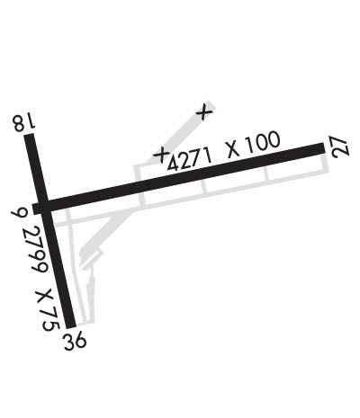
| Lat: N 4144.6 Long: W 07210.8 Elev: 246 Var: +15 Longest Runway: 4271 | ||
| Clr Del: 128.6 AWOS: 133.67 CTAF: 122.97 | ||
| ||||||
| ||||||
| ||||||
|
| Rwy | Rwy | |||||||
| 4271x100 | 4013' | 4271x100 | 4271' | 108.35 - 269° | ||||
| 2799x75 | 2799' | 2799x75 | 2000' | |||||
| Runway ID | Single Wheel | Double Wheel | Double Tandem Wheel | Dual Double Wheel |
| 09/27 | 30,000 | N/A | N/A | N/A |
| 18/36 | 30,000 | N/A | N/A | N/A |
| These numbers are Advisory and are not limits. The Airport Manager should have more accurate Weight Limits | ||||
 Airport Diagram might not be current. | |
| Facility Name: | WINDHAM |
| City Name: | WILLIMANTIC |
| County: | WINDHAM |
| State abbrev: | CT |
| State Name: | CONNECTICUT |
| Ownership: | PUBLICLY OWNED |
| Use: | OPEN TO THE PUBLIC |
| Owner's Name: | CONNECTICUT AIRPORT AUTHORITY |
| Address: | SUITE 160, 334 ELLA GRASSO TURNPIKE |
| WINDSOR LOCKS, CT 06096 | |
| Owner's Phone: | 860-292-2000 |
| Manager's Name: | BARRY PALLANCK |
| Address: | CONNECTICUT AIRPORT AUTHORITY, 155 TOWER AVE. |
| GROTON, CT 06340 | |
| Phone: | 860-883-6448 |
| FAA Region: | NEW ENGLAND |
| FAA Field Office: | NONE |
| Date | Sunrise | Sunset |
|---|---|---|
| 09/24/21 Friday | 6:38 | 18:43 |
| 09/25/21 Saturday | 6:39 | 18:41 |
| 09/26/21 Sunday | 6:40 | 18:39 |
| 09/27/21 Monday | 6:41 | 18:38 |
| 09/28/21 Tuesday | 6:42 | 18:36 |
| 09/29/21 Wednesday | 6:43 | 18:34 |
| 09/30/21 Thursday | 6:44 | 18:33 |
| 10/01/21 Friday | 6:45 | 18:31 |
| 10/02/21 Saturday | 6:46 | 18:29 |
| 10/03/21 Sunday | 6:47 | 18:27 |
| 10/04/21 Monday | 6:48 | 18:26 |
| 10/05/21 Tuesday | 6:50 | 18:24 |
| 10/06/21 Wednesday | 6:51 | 18:22 |
| 10/07/21 Thursday | 6:52 | 18:21 |
| Airport Attendance Schedule | UNATTENDED |
| Airport Status | OPERATIONAL (This Status can change at any time - please check NOTAMS) |
| Airport Lighting Schedule | ACTVT REIL RWY 27; MIRL RWY 09/27- CTAF. |
| Airport Storage Available | Tie Downs |
| Extra Services Available | Flight Instruction |
| Wind Indicator | YES - (unlit) |
| Control Tower | NO |
| CTAF Frequency | 122.975 |
| Unicom Frequency | 122.975 |
| Rotating Beacon Color | CLEAR-GREEN (Light Land Airport) |
| Segmented Circle | YES |
| Landing Fee | NO; LDG FEE FOR BUS/CORPORATE ACFT. |
| Airport Inspected | STATE - performed by STATE AERONAUTICAL PERSONNEL |
| Inspection Date | 03/30/2021 |
| Type of Fuel Available | Grade 100LL, JET A; -10SELF SVC FUEL, CREDIT CARD ONLY: VISA, MASTERCARD & DISCOVER.; -A+SELF SERVICE FUEL CREDIT CARD ONLY: VISA, MASTERCARD & DISCOVER. JET A HAS OVER WING AND SINGLE POINT NOZZLES. |
| Airframe Repair Service | MAJOR |
| Power Plant Repair Service | MAJOR |
| Latitude | N4144.6 |
| Longitude | W07210.8 (ESTIMATED) |
| Arpt Elevation | 246ft (SURVEYED) |
| Magnetic Variation | 15W |
| 3 miles NE | of WILLIMANTIC |
| Traffic Pattern Altitude | |
| Sectional Chart | NEW YORK |
| Operations (Reported) | Yearly | Avg. Daily |
|---|---|---|
| General Aviation Transient | 5800 | 16 |
| General Aviation Local | 8000 | 22 |
| Air Taxi | 100 | 0 |
| Commerical | 0 | 0 |
| Commuter | 0 | 0 |
| Military | 200 | 1 |
| Aircraft based on Field | |
|---|---|
| General Aviation Singles | 54 |
| General Aviation Multi | 1 |
| Jet Aircraft | 0 |
| General Aviation Helicopters | 0 |
| Military Aircraft | 0 |
| Gliders | 1 |
| Ultralights | 0 |
| FSS on field | NO |
| FSS tie-in | BRIDGEPORT |
| FSS Phone | 1-800-WX-BRIEF |
| Who issues Notams | IJD |
| Notam D service at airport | YES |
| ARTCC Name | BOSTON |
| Airport Certification | |
| Aircraft Rescue & Firefighting Index | None |
| Airport of Entry | No |
| Custom Landing Rights | No |
| Joint Civil/Military | No |
| Military Landing rights | YES |
| NATIONAL PLAN OF INTEGRATED AIRPORT SYSTEMS (NPIAS) |
| GRANT AGREEMENTS UNDER FAAP/ADAP/AIP |
| CONVEYANCE UNDER SCETION 16, FEDERAL AIRPORT ACT OF 1946 OR SECTION 23, AIRPORT AND AIRWAY DEVELOPMENT ACT OF 1970 |
| ASSURANCES PURSUANT TO TITLE VI, CIVIL RIGHTS ACT OF 1964 |
| AGREEMENT UNDER DLAND OR DCLA HAS EXPIRED. |
| 4 OBS LGTS ON SRNDG HILLS OTS INDEFLY. |
| BIRDS ON & INVOF ARPT. |
| FOR CD CTC YANKEE APCH AT 860-386-3597. |
Airport Communications & Frequencies:
| |||||||||||||||||||
| Runway: 09 | Runway: 27 | ||
| Mag heading: | 89° | Mag heading: | 269° |
| Rwy Slope: | .00% | Rwy Slope: | .00% |
| Approach: | Approach: | LOC/DME | |
| Pattern: | Left Traffic | Pattern: | Left Traffic |
| Markings: | NONPRECISION INSTRUMENT | Markings: | NONPRECISION INSTRUMENT |
| Marking Condition: | FAIR | Marking Condition: | FAIR |
| Arresting Dev: | Arresting Dev: | ||
| Lat & Long: | N4144.6 W07211.1 | Lat. & Long.: | N4144.8 W07210.2 |
| Elev: | 239.1 ft. MSL | Elev: | 239.1 ft. MSL |
| TCH: | TCH: | ||
| Visual Glide Path: | Visual Glide Path: | ||
| Displaced Threshold: | 258 feet | Displaced Threshold: | No |
| Touchdown Zone: | YES | Touchdown Zone: | YES |
| Touchdown Elev.: | 239.4 feet | Touchdown Elev.: | 239.4 feet |
| Visual Glide Slope: | Visual Glide Slope: | ||
| RVR Equipment: | RVR Equipment: | ||
| RVV Equipment: | NO | RVV Equipment: | NO |
| Approach Lights: | Approach Lights: | ||
| REIL: | NO | REIL: | YES |
| Centerline Lights: | NO | Centerline Lights: | NO |
| Touchdown lights: | NO | Touchdown lights: | NO |
| Runway Category: | Runway with a Non-precision Approach having visibility minimums greater than 3/4 mile | Runway Category: | Runway with a Non-precision Approach having visibility minimums greater than 3/4 mile |
| Declared Distances: | Declared Distances: | ||
| Obstructions: | TREES | Obstructions: | TREE |
| Marked: | NOT Marked/Lighted | Marked: | NOT Marked/Lighted |
| Clearance slope: | APCH RATIO 25:1 TO DSPLCD THR. | Clearance slope: | 5:1 |
| Obstruction height: | 53 feet AGL | Obstruction height: | 36 feet AGL |
| Dist. from runway: | 210 feet | Dist. from runway: | 415 feet |
| Centerline offset: | 220 left of centerline | Centerline offset: | 255 feet left of centerline |
| Comments: | Comments: |
| Runway: 18 | Runway: 36 | ||
| Mag heading: | 178° | Mag heading: | 358° |
| Rwy Slope: | .40% Up | Rwy Slope: | -.40% Down |
| Approach: | Approach: | ||
| Pattern: | Left Traffic | Pattern: | Left Traffic |
| Markings: | BASIC | Markings: | BASIC |
| Marking Condition: | GOOD | Marking Condition: | GOOD |
| Arresting Dev: | Arresting Dev: | ||
| Lat & Long: | N4144.8 W07211.1 | Lat. & Long.: | N4144.3 W07211.0 |
| Elev: | 234.8 ft. MSL | Elev: | 245.9 ft. MSL |
| TCH: | TCH: | ||
| Visual Glide Path: | Visual Glide Path: | ||
| Displaced Threshold: | No | Displaced Threshold: | 799 feet |
| Touchdown Zone: | YES | Touchdown Zone: | YES |
| Touchdown Elev.: | 246.1 feet | Touchdown Elev.: | 243.1 feet |
| Visual Glide Slope: | Visual Glide Slope: | ||
| RVR Equipment: | RVR Equipment: | ||
| RVV Equipment: | NO | RVV Equipment: | NO |
| Approach Lights: | Approach Lights: | ||
| REIL: | NO | REIL: | NO |
| Centerline Lights: | NO | Centerline Lights: | NO |
| Touchdown lights: | NO | Touchdown lights: | NO |
| Runway Category: | Runway with a Visual Approach | Runway Category: | Runway with a Visual Approach |
| Declared Distances: | Declared Distances: | ||
| Obstructions: | TREES | Obstructions: | TREES |
| Marked: | NOT Marked/Lighted | Marked: | NOT Marked/Lighted |
| Clearance slope: | 13:1 | Clearance slope: | 10:1; APCH RATIO 20:1 TO DSPLCD THR. |
| Obstruction height: | 46 feet AGL | Obstruction height: | 60 feet AGL |
| Dist. from runway: | 800 feet | Dist. from runway: | 800 feet |
| Centerline offset: | 200 right of centerline | Centerline offset: | 50 feet left of centerline |
| Comments: | Comments: |
Thanks for using FltPlan.com
all rights reserved © 1999-2021 by Flight Plan LLC
