NOTICE: Information listed below may not be current.Airport Ident: KIGX
| Airport Name: HORACE WILLIAMS, NORTH CAROLINA
Latitude: N3556.1 Longitude: W07904.0
Field Elevation: 512' Variation: W8° as of 01/06
Daylight Savings: N/A
Customs: N/A
|
|
| DISTANCE from: | KTEB to KIGX = 377 nm
| KMIA to KIGX = 612 nm
| KORD to KIGX = 549 nm
| KDAL to KIGX = 898 nm
| KSEA to KIGX = 2027 nm
| KLAX to KIGX = 1926 nm
|
|
| AIRPORT TYPE: | | Active civil airports controlled and operated by civil authorities primarily for use by civil aircraft, although military may have landing privileges and/or contract rights. Minimum facilities are available which include: control tower (or some similar control system, such as a Flight Service Station which issues clearances and advisories when there is no tower or the tower is not in operation), lighting (may be flare pots, etc.), petrol, oils and lubricants (POL), and facilities for organizational maintenance or better. |
|
Rotating Beacon: YES
|
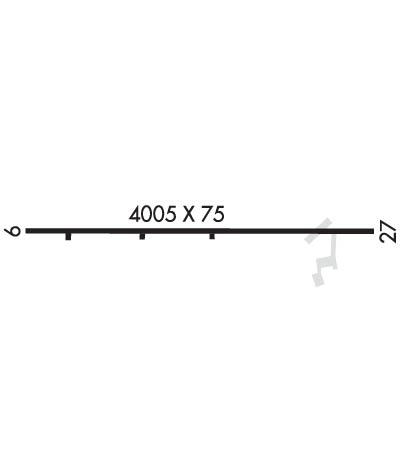
| RUNWAY INFORMATION: | Runway Ident: 27 /09
Runway Length: 4005
Runway Width: 75
Runway Surface: ASPHALT, ASPHALTIC CONCRETE, TAR MACADAM, OR BITUMEN BOUND MACADAM (INCLUDING ANY OF THESE SURFACE TYPES WITH CONCRETE ENDS).
Runway PCN Rating: -
Runway PCN Evaluation Method: N/A
Runway Open: YES
| Runway 27 Information
Runway True Heading: 262°
Runway Displaced Threshold: 51.1'
Takeoff Distance Available: 4005
Landing Distance Available: 3494
Runway Latitude: N3556.1
Runway Longitude: W07903.6
Runway Elevation: 488'
Runway Slope: .6°
Runway TDZE: 510'
Runway Lighting: PCL, MIRL, REIL, Alignment of Elements System (APAP), PAPI
| Runway 09 Information
Runway True Heading: 82°
Takeoff Distance Available: 4005
Landing Distance Available: 4005
Runway Latitude: N3556.1
Runway Longitude: W07904.4
Runway Elevation: 512'
Runway Slope: -.6°
Runway TDZE: 512
Runway Lighting: PCL, MIRL, REIL, Alignment of Elements System (APAP), PAPI
|
|
|
COMMUNICATION INFORMATION
APPROACH/DEPARTURE CONTROL - RALEIGH APP/DEP
132.35 256.9
AUTOMATED SURFACE OBSERVATION SYSTEM - ASOS
134.575
CLEARANCE DELIVERY - CLNC DEL
126.5
FLIGHT SERVICE STATION - RALEIGH RDO
UNICOM OR CTAF/UNICOM - CTAF/UNICOM
123.0
|
COMMUNICATION REMARKS
AUTOMATED SURFACE OBSERVATION SYSTEM - C919-942-2538.
|
AIRPORT NAVAIDS
RD - GREON (NDB) - Bearing: 321° Distance: 12.2 nm
RDU - RALEIGH-DURHAM (VORTAC) - Bearing: 294° Distance: 14.3 nm
|