
| LAUGHLIN/BULLHEAD INTL BULLHEAD CITY AZ |
| |
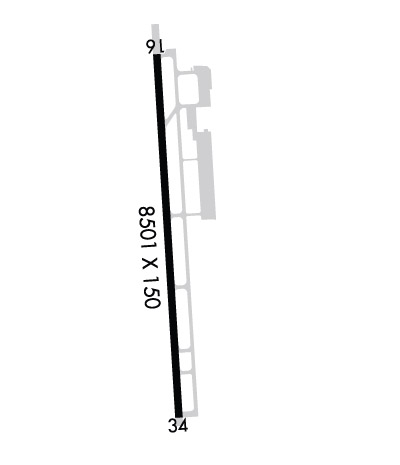
| Lat: N 3509.3 Long: W 11433.6 Elev: 707 Var: -12 Longest Runway: 8501 | ||
| Clr Del: 118.25 tw cld Dept. ATIS: 119.82 Arr. ATIS: 119.82 AWOS: 119.82 Ground: 118.25 Tower: 123.9 | ||
| ||||||||||||||||||||||||||||||||||||||||||||
| ||||||||||||||||||||||||||||||||||||||||||||
| ||||||||||||||||||||||||||||||||||||||||||||
| Rwy | Rwy | |||||||
| 8501x150 | 8501' | 8501x150 | 8501' | |||||
| Runway ID | Single Wheel | Double Wheel | Double Tandem Wheel | Dual Double Wheel |
| 16/34 | 75,000 | 200,000 | 400,000 | N/A |
| These numbers are Advisory and are not limits. The Airport Manager should have more accurate Weight Limits | ||||
 Airport Diagram might not be current. | |
| Facility Name: | LAUGHLIN/BULLHEAD INTL |
| City Name: | BULLHEAD CITY |
| County: | MOHAVE |
| State abbrev: | AZ |
| State Name: | ARIZONA |
| Ownership: | PUBLICLY OWNED |
| Use: | OPEN TO THE PUBLIC |
| Owner's Name: | MOHAVE COUNTY |
| Address: | BOX 390 |
| KINGMAN, AZ 86402 | |
| Owner's Phone: | |
| Manager's Name: | JEREMY KEATING; JEREMY KEATING-EMAIL: JKEATING@FLYIFP.COM |
| Address: | 2550 LAUGHLIN VIEW DR |
| BULLHEAD CITY, AZ 86429 | |
| Phone: | 928-754-2134 |
| FAA Region: | WESTERN-PACIFIC |
| FAA Field Office: | PHX |
| Date | Sunrise | Sunset |
|---|---|---|
| 09/24/21 Friday | 6:28 | 18:32 |
| 09/25/21 Saturday | 6:28 | 18:31 |
| 09/26/21 Sunday | 6:29 | 18:29 |
| 09/27/21 Monday | 6:30 | 18:28 |
| 09/28/21 Tuesday | 6:31 | 18:27 |
| 09/29/21 Wednesday | 6:31 | 18:25 |
| 09/30/21 Thursday | 6:32 | 18:24 |
| 10/01/21 Friday | 6:33 | 18:22 |
| 10/02/21 Saturday | 6:34 | 18:21 |
| 10/03/21 Sunday | 6:34 | 18:20 |
| 10/04/21 Monday | 6:35 | 18:18 |
| 10/05/21 Tuesday | 6:36 | 18:17 |
| 10/06/21 Wednesday | 6:37 | 18:15 |
| 10/07/21 Thursday | 6:38 | 18:14 |
| Airport Attendance Schedule | CONTINUOUS; FOR SVCS & FUEL 0600-0000 CTC FREQ 122.85 , BTN 0000-0600 SVCS & FUEL NOT AVBL. |
| Airport Status | OPERATIONAL (This Status can change at any time - please check NOTAMS) |
| Airport Lighting Schedule | ACTVT MIRL RWY 16/34; REIL RWY 16/34 - CTAF. |
| Airport Storage Available | Tie Downs, Hanger |
| Extra Services Available | Air Freight, Air Ambulance, Charter |
| Wind Indicator | YES - (lighted) |
| Control Tower | YES |
| CTAF Frequency | 123.900 |
| Unicom Frequency | |
| Rotating Beacon Color | CLEAR-GREEN (Light Land Airport) |
| Segmented Circle | YES |
| Landing Fee | NO |
| Airport Inspected | FEDERAL - performed by FAA AIRPORTS FIELD PERSONNEL |
| Inspection Date | 05/20/2019 |
| Type of Fuel Available | Grade 100LL, JET A (freeze point -40C) |
| Airframe Repair Service | None |
| Power Plant Repair Service | None |
| Latitude | N3509.3 |
| Longitude | W11433.6 (ESTIMATED) |
| Arpt Elevation | 707ft (SURVEYED) |
| Magnetic Variation | 12E |
| 1 miles N | of BULLHEAD CITY |
| Traffic Pattern Altitude | |
| Sectional Chart | PHOENIX |
| Operations (Reported) | Yearly | Avg. Daily |
|---|---|---|
| General Aviation Transient | 5685 | 16 |
| General Aviation Local | 1024 | 3 |
| Air Taxi | 1862 | 5 |
| Commerical | 1502 | 4 |
| Commuter | 0 | 0 |
| Military | 451 | 1 |
| Aircraft based on Field | |
|---|---|
| General Aviation Singles | 14 |
| General Aviation Multi | 6 |
| Jet Aircraft | 2 |
| General Aviation Helicopters | 4 |
| Military Aircraft | 0 |
| Gliders | 0 |
| Ultralights | 0 |
| FSS on field | NO |
| FSS tie-in | PRESCOTT |
| FSS Phone | 1-800-WX-BRIEF |
| Who issues Notams | IFP |
| Notam D service at airport | YES |
| ARTCC Name | LOS ANGELES |
| Airport Certification | AIRPORT RECEIVING SCHEDULED AIR CARRIER SERVICE FROM CARRIERS CERTIFICATED BY THE CIVIL AERONAUTICS BOARD |
| Aircraft Rescue & Firefighting Index | AIRPORT HAS A CERTIFICATE UNDER CFR PART 139 |
| Airport of Entry | No |
| Custom Landing Rights | No |
| Joint Civil/Military | No |
| Military Landing rights | YES |
| NATIONAL PLAN OF INTEGRATED AIRPORT SYSTEMS (NPIAS) |
| GRANT AGREEMENTS UNDER FAAP/ADAP/AIP |
| ASSURANCES PURSUANT TO TITLE VI, CIVIL RIGHTS ACT OF 1964 |
| MTNS NW, NE, E AND SE. |
| NOISE SENSITIVE AREAS NE AND SE OF ARPT. |
| SFC CONDITIONS NOT MONITORED 0600Z-1200Z DAILY. |
| TWY A5 BTN TWY-A AND GEN AVIATION APRON LTD TO ACFT WITH WINGSPAN LESS THAN 79 FT. |
| NO RADAR SERVICES AVBL BLW 6000 FT. |
| LARGE COMMERCIAL AIRLINE ACFT OPERATING AFTER TWR HRS. |
| RISING TERRAIN TO THE NORTH & SOUTH OF RY ENDS. |
| POWERLINE PARALLEL TO RY 16 625 FT LEFT OF CNTRLN 1300 FT FROM RY END 66 FT HIGH. |
| TPA FOR LIGHT ACFT 999 FT AGL, TPA FOR HIGH PERFORMANCE ACFT 1499 FT AGL. |
| TWY ALPHA 4 LIMITED TO ACFT WITH WINGSPANS LESS THAN 79 FT. |
| BIRDS ON AND IN VICINITY OF AIRPORT SEP-DEC. |
Airport Communications & Frequencies:
| |||||||||||||
| Runway: 16 | Runway: 34 | ||
| Mag heading: | 164° | Mag heading: | 344° |
| Rwy Slope: | .96% Up | Rwy Slope: | -.96% Down |
| Approach: | Approach: | ||
| Pattern: | Right Traffic | Pattern: | Left Traffic |
| Markings: | NONPRECISION INSTRUMENT | Markings: | NONPRECISION INSTRUMENT |
| Marking Condition: | GOOD | Marking Condition: | GOOD |
| Arresting Dev: | Arresting Dev: | ||
| Lat & Long: | N3510.0 W11433.6 | Lat. & Long.: | N3508.6 W11433.5 |
| Elev: | 625.5 ft. MSL | Elev: | 707.1 ft. MSL |
| TCH: | 49 ft. AGL | TCH: | 45 ft. AGL |
| Visual Glide Path: | 3.00 degrees | Visual Glide Path: | 3.00 degrees |
| Displaced Threshold: | No | Displaced Threshold: | No |
| Touchdown Zone: | YES | Touchdown Zone: | YES |
| Touchdown Elev.: | 645.5 feet | Touchdown Elev.: | 707.1 feet |
| Visual Glide Slope: | 4-Light PAPI on LEFT side of Runway | Visual Glide Slope: | 4-Light PAPI on LEFT side of Runway |
| RVR Equipment: | RVR Equipment: | ||
| RVV Equipment: | NO | RVV Equipment: | NO |
| Approach Lights: | Approach Lights: | ||
| REIL: | YES | REIL: | YES |
| Centerline Lights: | NO | Centerline Lights: | NO |
| Touchdown lights: | NO | Touchdown lights: | NO |
| Runway Category: | Runway with a Non-precision Approach having visibility minimums greater than 3/4 mile | Runway Category: | Runway with a Non-precision Approach having visibility minimums greater than 3/4 mile |
| Declared Distances: | TORA:8500' TODA:8500' ASDA:8500' LDA:8500' | Declared Distances: | TORA:8500' TODA:8500' ASDA:8500' LDA:8500' |
| Obstructions: | POLE | Obstructions: | |
| Marked: | NOT Marked/Lighted | Marked: | |
| Clearance slope: | 24:1 | Clearance slope: | 50:1 |
| Obstruction height: | 123 feet AGL | Obstruction height: | |
| Dist. from runway: | 3200 feet | Dist. from runway: | |
| Centerline offset: | 550 left of centerline | Centerline offset: | |
| Comments: | Comments: |
Thanks for using FltPlan.com
all rights reserved © 1999-2021 by Flight Plan LLC