| IDAHO FALLS RGNL IDAHO FALLS ID |
| |
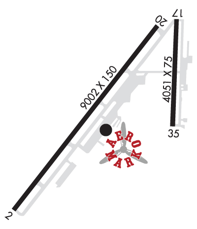
| Lat: N 4330.8 Long: W 11204.2 Elev: 4744 Var: -12 Longest Runway: 9002 | ||
| Clr Del: 121.7 Dept. ATIS: 135.32 Arr. ATIS: 135.32 AWOS: 135.32 Ground: 121.7 Tower: 118.5 | ||
| |||||||||||||||||||||||||||||||||||||||||||||||||||||||||||||||||||||
| |||||||||||||||||||||||||||||||||||||||||||||||||||||||||||||||||||||
| |||||||||||||||||||||||||||||||||||||||||||||||||||||||||||||||||||||
| Rwy | Rwy | |||||||
| 9002x150 | 9002' | 9002x150 | 9002' | 111.10 - 206° | ||||
| 3964x75 | 3964' | 3964x75 | 3964' | |||||
| Runway ID | Single Wheel | Double Wheel | Double Tandem Wheel | Dual Double Wheel |
| 03/21 | 140,000 | 175,000 | 270,000 | N/A |
| 17/35 | 43,000 | 58,000 | N/A | N/A |
| These numbers are Advisory and are not limits. The Airport Manager should have more accurate Weight Limits | ||||
 Airport Diagram might not be current. | |
| Facility Name: | IDAHO FALLS RGNL |
| City Name: | IDAHO FALLS |
| County: | BONNEVILLE |
| State abbrev: | ID |
| State Name: | IDAHO |
| Ownership: | PUBLICLY OWNED |
| Use: | OPEN TO THE PUBLIC |
| Owner's Name: | CITY OF IDAHO FALLS |
| Address: | PO BOX 50220 |
| IDAHO FALLS, ID 83405 | |
| Owner's Phone: | 208-612-8224 |
| Manager's Name: | RICK CLOUTIER; AIRPORT DIRECTOR |
| Address: | 2140 N SKYLINE |
| IDAHO FALLS, ID 83402 | |
| Phone: | (208) 612-8224 |
| FAA Region: | NORTHWEST MOUNTAIN |
| FAA Field Office: | HLN |

| Date | Sunrise | Sunset |
|---|---|---|
| 09/24/21 Friday | 7:18 | 19:22 |
| 09/25/21 Saturday | 7:19 | 19:20 |
| 09/26/21 Sunday | 7:20 | 19:19 |
| 09/27/21 Monday | 7:21 | 19:17 |
| 09/28/21 Tuesday | 7:22 | 19:15 |
| 09/29/21 Wednesday | 7:23 | 19:13 |
| 09/30/21 Thursday | 7:24 | 19:11 |
| 10/01/21 Friday | 7:26 | 19:10 |
| 10/02/21 Saturday | 7:27 | 19:08 |
| 10/03/21 Sunday | 7:28 | 19:06 |
| 10/04/21 Monday | 7:29 | 19:04 |
| 10/05/21 Tuesday | 7:30 | 19:02 |
| 10/06/21 Wednesday | 7:31 | 19:01 |
| 10/07/21 Thursday | 7:33 | 18:59 |
| Airport Attendance Schedule | 7 Days A Week 0530-2130; ON CALL 24 HRS PHONE 208-390-8746 OR 208-390-3624. |
| Airport Status | OPERATIONAL (This Status can change at any time - please check NOTAMS) |
| Airport Lighting Schedule | WHEN ATCT CLSD, ACTVT MALSR RWY 21; REIL RWY 03; PAPI RWY 03; HIRL RWY 03/21 - CTAF. |
| Airport Storage Available | Tie Downs, Hanger |
| Extra Services Available | Air Freight, Avionics, Cargo Handling, Charter, Flight Instruction, Aircraft Rental, Aircraft Sales |
| Wind Indicator | YES - (lighted) |
| Control Tower | YES |
| CTAF Frequency | 118.500 |
| Unicom Frequency | 122.950 |
| Rotating Beacon Color | CLEAR-GREEN (Light Land Airport) |
| Segmented Circle | YES |
| Landing Fee | NO |
| Airport Inspected | FEDERAL - performed by FAA AIRPORTS FIELD PERSONNEL |
| Inspection Date | 01/27/2020 |
| Type of Fuel Available | Grade 100LL, JET A-1 (freeze point -50C) |
| Airframe Repair Service | MAJOR |
| Power Plant Repair Service | MAJOR |
| Latitude | N4330.8 |
| Longitude | W11204.2 (ESTIMATED) |
| Arpt Elevation | 4743ft (SURVEYED) |
| Magnetic Variation | 12E |
| 2 miles NW | of IDAHO FALLS |
| Traffic Pattern Altitude | TPA 1500 AGL (MULTI-ENG/TURBOJET ACFT), 1000 AGL (SGL ENG ACFT), 500 AGL (ROTORCRAFT). |
| Sectional Chart | SALT LAKE CITY |
| Operations (Reported) | Yearly | Avg. Daily |
|---|---|---|
| General Aviation Transient | 13058 | 36 |
| General Aviation Local | 8535 | 23 |
| Air Taxi | 10140 | 28 |
| Commerical | 1152 | 3 |
| Commuter | 0 | 0 |
| Military | 267 | 1 |
| Aircraft based on Field | |
|---|---|
| General Aviation Singles | 128 |
| General Aviation Multi | 29 |
| Jet Aircraft | 6 |
| General Aviation Helicopters | 5 |
| Military Aircraft | 0 |
| Gliders | 3 |
| Ultralights | 0 |
| FSS on field | NO |
| FSS tie-in | BOISE |
| FSS Phone | 1-800-WX-BRIEF |
| Who issues Notams | IDA |
| Notam D service at airport | YES |
| ARTCC Name | SALT LAKE CITY |
| Airport Certification | AIRPORT RECEIVING SCHEDULED AIR CARRIER SERVICE FROM CARRIERS CERTIFICATED BY THE CIVIL AERONAUTICS BOARD; 24 HR PPR FOR UNSKED ACR OPNS WITH MORE THAN 30 PAX SEATS CALL AMGR 208-612-8224. |
| Aircraft Rescue & Firefighting Index | AIRPORT HAS A CERTIFICATE UNDER CFR PART 139 |
| Airport of Entry | No |
| Custom Landing Rights | No |
| Joint Civil/Military | No |
| Military Landing rights | YES |
| NATIONAL PLAN OF INTEGRATED AIRPORT SYSTEMS (NPIAS) |
| GRANT AGREEMENTS UNDER FAAP/ADAP/AIP |
| ASSURANCES PURSUANT TO TITLE VI, CIVIL RIGHTS ACT OF 1964 |
| AGREEMENT UNDER DLAND OR DCLA HAS EXPIRED. |
| WHEN ATCT CLSD, TWY A BTN A1 AND HOLD SHORT LINE FOR RWY 17 IS CLSD TO PROTECT RWY 21 PA. |
| FQT VEHICLE TFC ON EAST RAMP ADJ TO TWY B. |
| FOR CD IF UNA TO CTC ON FSS FREQ, CTC SALT LAKE ARTCC AT 801-320-2568. |
| FLOCKS OF BIRDS & WATERFOWL ON & INVOF ARPT ALL YEAR. |
| EXTSV AGRICULTURAL OPNS INVOF OF ARPT. |
| ACFT OPS BE ALERT FOR POSSIBLE INCURSIONS; NO LINE OF SIGHT BTN RWYS. |
| SFC CONDITIONS UNMONITORED 2300-0530. |
| RWY 21 AND RWY 17 APCH ENDS IN CLOSE PROXIMITY. WRONG RWY DEP/ARR RISK. CHK RWY ALNMT. INTERSECTING FLT PATHS FOR RWYS 21 & 17, AND RWYS 03 & 35. |
| SELF SVC FUEL EAST OF TWY BRAVO AVBL 24 HRS. |
| ALL COMMERCIAL ACFT ADVISE PRIOR TO PUSHBACK. |
| IDA SVC GND COM OUTLET CMSND KEY FREQ 121.725: 2 TIMES FUEL DLVY; 4 TIMES SLC ARTCC; 6 TIMES BOI FSS; 8 TIMES 911 DISPATCH SVC WHEN TWR CLSD. |
| RWY 17/3 5 TKOF/LDG NA SS-SR EXC WHEN ATCT AVBL. |
Airport Communications & Frequencies:
| |||||||||||||||||||||
| Runway: 03 | Runway: 21 | ||
| Mag heading: | 26° | Mag heading: | 206° |
| Rwy Slope: | -.12% Down | Rwy Slope: | .12% Up |
| Approach: | Approach: | ILS/DME | |
| Pattern: | Left Traffic | Pattern: | Left Traffic |
| Markings: | PRECISION INSTRUMENT | Markings: | PRECISION INSTRUMENT |
| Marking Condition: | GOOD | Marking Condition: | GOOD |
| Arresting Dev: | Arresting Dev: | ||
| Lat & Long: | N4330.2 W11205.1 | Lat. & Long.: | N4331.3 W11203.9 |
| Elev: | 4742.0 ft. MSL | Elev: | 4731.3 ft. MSL |
| TCH: | 50 ft. AGL | TCH: | 50 ft. AGL |
| Visual Glide Path: | 3.00 degrees | Visual Glide Path: | 3.00 degrees |
| Displaced Threshold: | No | Displaced Threshold: | No |
| Touchdown Zone: | YES | Touchdown Zone: | YES |
| Touchdown Elev.: | 4743.7 feet | Touchdown Elev.: | 4734.6 feet |
| Visual Glide Slope: | 4-Light PAPI on LEFT side of Runway | Visual Glide Slope: | 4-Light PAPI on LEFT side of Runway |
| RVR Equipment: | ROLLOUT | RVR Equipment: | TOUCHDOWN |
| RVV Equipment: | NO | RVV Equipment: | NO |
| Approach Lights: | Approach Lights: | MALSR - 1,400 foot medium intensity approach lighting system with runway alignment indicator lights | |
| REIL: | YES | REIL: | NO |
| Centerline Lights: | NO | Centerline Lights: | NO |
| Touchdown lights: | NO | Touchdown lights: | NO |
| Runway Category: | D | Runway Category: | Precision Instrument Runway |
| Declared Distances: | TORA:9002' TODA:9002' ASDA:9002' LDA:9002' | Declared Distances: | TORA:9002' TODA:9002' ASDA:9002' LDA:9002' |
| Runway: 17 | Runway: 35 | ||
| Mag heading: | 170° | Mag heading: | 350° |
| Rwy Slope: | .00% Up | Rwy Slope: | .00% Down |
| Approach: | Approach: | ||
| Pattern: | Left Traffic | Pattern: | Left Traffic |
| Markings: | BASIC | Markings: | BASIC |
| Marking Condition: | GOOD | Marking Condition: | GOOD |
| Arresting Dev: | Arresting Dev: | ||
| Lat & Long: | N4331.3 W11203.7 | Lat. & Long.: | N4330.7 W11203.7 |
| Elev: | 4731.1 ft. MSL | Elev: | 4731.2 ft. MSL |
| TCH: | 40 ft. AGL | TCH: | 45 ft. AGL |
| Visual Glide Path: | 3.00 degrees | Visual Glide Path: | 3.50 degrees |
| Displaced Threshold: | No | Displaced Threshold: | No |
| Touchdown Zone: | YES | Touchdown Zone: | YES |
| Touchdown Elev.: | 4736.0 feet | Touchdown Elev.: | 4736.0 feet |
| Visual Glide Slope: | 2-Light PAPI on LEFT side of Runway | Visual Glide Slope: | 4-Light PAPI on LEFT side of Runway |
| RVR Equipment: | RVR Equipment: | ||
| RVV Equipment: | NO | RVV Equipment: | NO |
| Approach Lights: | Approach Lights: | ||
| REIL: | NO | REIL: | NO |
| Centerline Lights: | NO | Centerline Lights: | NO |
| Touchdown lights: | NO | Touchdown lights: | NO |
| Runway Category: | Runway with a Visual Approach | Runway Category: | Runway with a Visual Approach |
| Declared Distances: | Declared Distances: | ||
| Obstructions: | Obstructions: | ANT | |
| Marked: | Marked: | NOT Marked/Lighted | |
| Clearance slope: | Clearance slope: | 21:1 | |
| Obstruction height: | Obstruction height: | 23 feet AGL | |
| Dist. from runway: | Dist. from runway: | 700 feet | |
| Centerline offset: | Centerline offset: | 80 feet left of centerline | |
| Comments: | Comments: |
Thanks for using FltPlan.com
all rights reserved © 1999-2021 by Flight Plan LLC