
| GEORGE BUSH INTERCONTINENTAL HOUSTON TX |
| |
| Lat: N 2959.1 Long: W 09520.5 Elev: 96 Var: -03 Longest Runway: 12001 | ||
| Clr Del: 128.1 Dept. ATIS: 124.05 Arr. ATIS: 124.05 Ground: 121.7/118.57 Tower: 127.3/125.35 | ||

| |||||||||||||||||||||||||||||||||||||||||||||||||||||||||||||||||||||
| |||||||||||||||||||||||||||||||||||||||||||||||||||||||||||||||||||||
| |||||||||||||||||||||||||||||||||||||||||||||||||||||||||||||||||||||
| |||||||||||||||||||||||||||||||||||||||||||||||||||||||||||||||||||||
| |||||||||||||||||||||||||||||||||||||||||||||||||||||||||||||||||||||
| FBOs at nearby airports who want your business: | |||||||||||||||||
| |||||||||||||||||
| Rwy | Rwy | |||||||
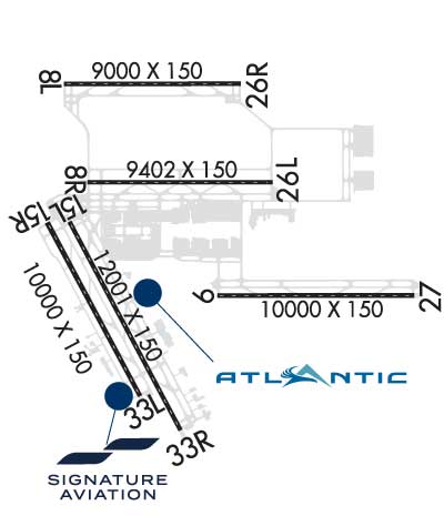
| 9000x150 | 9000' | 111.55 - 086° | 9000x150 | 9000' | 111.55 - 266° | |||
| 9402x150 | 9402' | 109.70 - 086° | 9402x150 | 9402' | 109.70 - 266° | |||
| 10000x150 | 10000' | 110.90 - 086° | 10000x150 | 10000' | 110.90 - 266° | |||
| 12001x150 | 12001' | 12001x150 | 12001' | 111.90 - 328° | ||||
| 10000x150 | 10000' | 111.15 - 148° | 10000x150 | 10000' | ||||
| Runway ID | Single Wheel | Double Wheel | Double Tandem Wheel | Dual Double Wheel |
| 08L/26R | 75,000 | 210,000 | 409,000 | 873,000 |
| 08R/26L | 75,000 | 210,000 | 498,000 | 873,000 |
| 09/27 | N/A | 210,000 | 560,000 | N/A |
| 15L/33R | 100,000 | 200,000 | 400,000 | 800,000 |
| 15R/33L | 75,000 | 200,000 | 400,000 | 873,000 |
| These numbers are Advisory and are not limits. The Airport Manager should have more accurate Weight Limits | ||||
 Airport Diagram might not be current. | |
| Facility Name: | GEORGE BUSH INTCNTL/HOUSTON |
| City Name: | HOUSTON |
| County: | HARRIS |
| State abbrev: | TX |
| State Name: | TEXAS |
| Ownership: | PUBLICLY OWNED |
| Use: | OPEN TO THE PUBLIC |
| Owner's Name: | CITY OF HOUSTON |
| Address: | PO BOX 60106 |
| HOUSTON, TX 77205 | |
| Owner's Phone: | 281-233-3000; DEPT OF AVIATION, ADMIN OFFICE. |
| Manager's Name: | STEVEN RUNGE |
| Address: | PO BOX 60106 |
| HOUSTON, TX 77205 | |
| Phone: | 281-230-3100 |
| FAA Region: | SOUTHWEST |
| FAA Field Office: | TEX |
| Date | Sunrise | Sunset |
|---|---|---|
| 09/24/21 Friday | 7:11 | 19:16 |
| 09/25/21 Saturday | 7:11 | 19:14 |
| 09/26/21 Sunday | 7:12 | 19:13 |
| 09/27/21 Monday | 7:12 | 19:12 |
| 09/28/21 Tuesday | 7:13 | 19:11 |
| 09/29/21 Wednesday | 7:13 | 19:09 |
| 09/30/21 Thursday | 7:14 | 19:08 |
| 10/01/21 Friday | 7:15 | 19:07 |
| 10/02/21 Saturday | 7:15 | 19:06 |
| 10/03/21 Sunday | 7:16 | 19:05 |
| 10/04/21 Monday | 7:16 | 19:03 |
| 10/05/21 Tuesday | 7:17 | 19:02 |
| 10/06/21 Wednesday | 7:18 | 19:01 |
| 10/07/21 Thursday | 7:18 | 19:00 |
| Airport Attendance Schedule | CONTINUOUS |
| Airport Status | OPERATIONAL (This Status can change at any time - please check NOTAMS) |
| Airport Lighting Schedule | SS-SR |
| Airport Storage Available | Tie Downs, Hanger |
| Extra Services Available | Air Freight, Avionics, Cargo Handling |
| Wind Indicator | YES - (lighted) |
| Control Tower | YES |
| CTAF Frequency | |
| Unicom Frequency | 122.950 |
| Rotating Beacon Color | CLEAR-GREEN (Light Land Airport) |
| Segmented Circle | NO |
| Landing Fee |
| Airport Inspected | FEDERAL - performed by FAA AIRPORTS FIELD PERSONNEL |
| Inspection Date | 03/21/2019 |
| Type of Fuel Available | Grade 100LL, JET A (freeze point -40C) |
| Airframe Repair Service | MAJOR |
| Power Plant Repair Service | MAJOR |
| Latitude | N2959.1 |
| Longitude | W09520.5 (ESTIMATED) |
| Arpt Elevation | 95ft (SURVEYED) |
| Magnetic Variation | 03E |
| 15 miles N | of HOUSTON |
| Traffic Pattern Altitude | |
| Sectional Chart | HOUSTON |
| Operations (Reported) | Yearly | Avg. Daily |
|---|---|---|
| General Aviation Transient | 6209 | 17 |
| General Aviation Local | 0 | 0 |
| Air Taxi | 51990 | 142 |
| Commerical | 192856 | 528 |
| Commuter | 0 | 0 |
| Military | 200 | 1 |
| Aircraft based on Field | |
|---|---|
| General Aviation Singles | 0 |
| General Aviation Multi | 0 |
| Jet Aircraft | 36 |
| General Aviation Helicopters | 0 |
| Military Aircraft | 0 |
| Gliders | 0 |
| Ultralights | 0 |
| FSS on field | NO |
| FSS tie-in | MONTGOMERY COUNTY |
| FSS Phone | 1-800-WX-BRIEF |
| Who issues Notams | IAH |
| Notam D service at airport | YES |
| ARTCC Name | HOUSTON |
| Airport Certification | AIRPORT RECEIVING SCHEDULED AIR CARRIER SERVICE FROM CARRIERS CERTIFICATED BY THE CIVIL AERONAUTICS BOARD |
| Aircraft Rescue & Firefighting Index | AIRPORT HAS A CERTIFICATE UNDER CFR PART 139 |
| Airport of Entry | No |
| Custom Landing Rights | YES |
| Joint Civil/Military | No |
| Military Landing rights | YES |
| NATIONAL PLAN OF INTEGRATED AIRPORT SYSTEMS (NPIAS) |
| GRANT AGREEMENTS UNDER FAAP/ADAP/AIP |
| ASSURANCES PURSUANT TO TITLE VI, CIVIL RIGHTS ACT OF 1964 |
| TWY 'NR' CLSD TO ACFT WITH WING SPANS GREATER THAN 125 FT BTN TWY 'WD' & TWY 'WB'. |
| TWY 'SF' BTN TWY 'NB' AND TXLN 'RA' IS DSGND NON-MOVEMENT AREA. |
| DUAL TWY OPNS TWY NK BTN TWY NB & NORTH RAMP; WEST CNTRLN RSTRD TO ACFT MAX WING SPANS 125 FT & EAST CNTRLN MAX WING SPANS 214 FT. |
| BIRDS ON & IN VCNTY OF ARPT. |
| THE FLWG MOVEMENT AREAS ARE NOT VSB FM THE ATCT: PORTIONS OF TWYS 'WA' & 'WB' FM TWY 'WH' TO THE AER 33R; TWYS 'WA' & 'WB' FM TWY 'WD' NORTH FOR 400 FT; TWY 'WD' FM TWY 'WA' TO TWY 'NR'; TWY 'NR'; TWY 'WL' FM RY 15L TO TWY 'WB' & TWY 'WM'. |
| NORTH RAMP NORTH & SOUTH TAXI LANES CLSD TO ACFT WITH WING SPANS GREATER THAN 125 FT. |
| TXLN 'RA', 'RB', 'RC', 'R2', AND TWY 'SC' NORTH OF TWY 'SB' ARE DSGND NON-MOVEMENT AREAS OPERD BY UAL RAMP CTL. |
| RY 15L/33R MAGNETIC ANOMALIES MAY AFFECT COMPASS HDG FOR TKOF. |
| TWYS WA & WB MAGNETIC ANOMALIES MAY AFFECT COMPASS HDG. |
| NORTH RAMP TAXILANE BTN TWYS NF & NR RSTRD TO ACFT WITH WING SPAN 125 FT & BLO. |
| TWY WC WEST OF RY 15R/33L RSTRD TO ACFT WITH 118 FT WING SPAN AND BLO. |
| ASDE-X IN USE. OPERATE TRANSPONDERS WITH ALTITUDE REPORTING MODE AND ADS-B (IF EQUIPPED) ENABLED ON ALL AIRPORT SURFACES. |
| NOISE SENSITIVE AREA N, E AND W OF ARPT. |
| TXLN RC CLSD TO ACFT WITH WINGSPAN GREATER THAN 135 FT. |
| RY STATUS LGTS ARE IN OPN. |
| TWY WW RUN UP PAD FOR RY 15L CLSD TO ACFT WITH WINGSPAN 135 FT & OVER. |
| RY 09/27 CLSD TO ACFT WITH WINGSPAN 215 FT & ABOVE. |
| TWY SF BTN RY 09/27 UP TO AND INCLUDING THE EAST BRIDGE CLSD TO ACFT WITH WINGSPAN 215 FT & OVER. |
| TWY NR BTN TWY NC AND TWY WW CLSD TO ACFT WINGSPAN MORE THAN 214 FT. |
| TWY WW BTN TWY NR AND TWY WB CLSD TO ACFT WINGSPAN MORE THAN 214 FT. |
| TWY NR BTN WW AND TWY WB DSGND NON-MOVEMENT AREA. |
| TWY NK BTN TWY NB AND TERMINAL D RAMP SIMULTANEOUS ACFT OPS PROHIBITED WHEN MIDDLE TAXILANE IN USE. |
| HELICOPTER HOVER/TAXI RSTRD TO HARD SFC MOVEMENT AREAS ONLY. |
| GBAS APCH SVC VOL 20NM FR THLD, ALL GLS APCHS. |
| HEL HOVER/TAXI RSTRD TO HARD SFC MOVEMENT AREAS ONLY. |
| 9 FT AGL UNMKD SECURITY FENCE ADJ TO FBO & CORPORATE BASE OPERATOR RAMPS AND NONMOVEMENT AREA TAXILANES. |
| GBAS APCH SVC VOL 20NM FR THLD, ALL GLS APCHS. |
| TWY NA LGT ALL BTN TWY WP AND TWY NP NOT STD |
| PILOTS & CREWS SHOULD BE AWARE OF DEP TURNS ON CRS IN EXCESS OF 180 DEGS. PILOT READ BACK OF DRCTN OF TURN IS HIGHLY ENCOURAGED. |
Airport Communications & Frequencies:
| |||||||||||||||||||||||||||||||||||||||||||||||||||||||
| Runway: 08L | Runway: 26R | ||
| Mag heading: | 87° | Mag heading: | 267° |
| Rwy Slope: | .04% Up | Rwy Slope: | -.04% Down |
| Approach: | ILS/DME | Approach: | ILS/DME |
| Pattern: | Left Traffic | Pattern: | Left Traffic |
| Markings: | PRECISION INSTRUMENT | Markings: | PRECISION INSTRUMENT |
| Marking Condition: | GOOD | Marking Condition: | GOOD |
| Arresting Dev: | Arresting Dev: | ||
| Lat & Long: | N3000.4 W09521.5 | Lat. & Long.: | N3000.4 W09519.8 |
| Elev: | 90.6 ft. MSL | Elev: | 94.2 ft. MSL |
| TCH: | TCH: | ||
| Visual Glide Path: | Visual Glide Path: | ||
| Displaced Threshold: | No | Displaced Threshold: | No |
| Touchdown Zone: | YES | Touchdown Zone: | YES |
| Touchdown Elev.: | 94.0 feet | Touchdown Elev.: | 95.3 feet |
| Visual Glide Slope: | Visual Glide Slope: | ||
| RVR Equipment: | TOUCHDOWN-MIDFIELD-ROLLOUT | RVR Equipment: | TOUCHDOWN-MIDFIELD-ROLLOUT |
| RVV Equipment: | NO | RVV Equipment: | NO |
| Approach Lights: | ALSF2 - standard 2,400 foot high intensity approach lighting system with sequenced flashers, Category II or III | Approach Lights: | ALSF2 - standard 2,400 foot high intensity approach lighting system with sequenced flashers, Category II or III |
| REIL: | NO | REIL: | NO |
| Centerline Lights: | YES | Centerline Lights: | YES |
| Touchdown lights: | YES | Touchdown lights: | YES |
| Runway Category: | Precision Instrument Runway | Runway Category: | Precision Instrument Runway |
| Declared Distances: | TORA:9000' TODA:9000' ASDA:9000' LDA:9000' | Declared Distances: | TORA:9000' TODA:9000' ASDA:9000' LDA:9000' |
| Runway: 08R | Runway: 26L | ||
| Mag heading: | 87° | Mag heading: | 267° |
| Rwy Slope: | -.02% Down | Rwy Slope: | .02% Up |
| Approach: | ILS/DME | Approach: | ILS/DME |
| Pattern: | Left Traffic | Pattern: | Left Traffic |
| Markings: | PRECISION INSTRUMENT | Markings: | PRECISION INSTRUMENT |
| Marking Condition: | GOOD | Marking Condition: | GOOD |
| Arresting Dev: | Arresting Dev: | ||
| Lat & Long: | N2959.6 W09521.3 | Lat. & Long.: | N2959.6 W09519.5 |
| Elev: | 94.3 ft. MSL | Elev: | 92.3 ft. MSL |
| TCH: | 72 ft. AGL | TCH: | 71 ft. AGL |
| Visual Glide Path: | 3.00 degrees | Visual Glide Path: | 3.00 degrees |
| Displaced Threshold: | No | Displaced Threshold: | No |
| Touchdown Zone: | YES | Touchdown Zone: | YES |
| Touchdown Elev.: | 95.3 feet | Touchdown Elev.: | 94.6 feet |
| Visual Glide Slope: | 4-Light PAPI on LEFT side of Runway | Visual Glide Slope: | 4-Light PAPI on RIGHT side of Runway |
| RVR Equipment: | TOUCHDOWN-MIDFIELD-ROLLOUT | RVR Equipment: | TOUCHDOWN-MIDFIELD-ROLLOUT |
| RVV Equipment: | NO | RVV Equipment: | NO |
| Approach Lights: | MALSR - 1,400 foot medium intensity approach lighting system with runway alignment indicator lights | Approach Lights: | ALSF2 - standard 2,400 foot high intensity approach lighting system with sequenced flashers, Category II or III |
| REIL: | NO | REIL: | NO |
| Centerline Lights: | YES | Centerline Lights: | YES |
| Touchdown lights: | YES | Touchdown lights: | YES |
| Runway Category: | Precision Instrument Runway | Runway Category: | Precision Instrument Runway |
| Declared Distances: | TORA:9402' TODA:9402' ASDA:9402' LDA:9402' | Declared Distances: | TORA:9402' TODA:9402' ASDA:9402' LDA:9402' |
| Runway: 09 | Runway: 27 | ||
| Mag heading: | 87° | Mag heading: | 267° |
| Rwy Slope: | -.06% Down | Rwy Slope: | .06% Up |
| Approach: | ILS/DME | Approach: | ILS/DME |
| Pattern: | Left Traffic | Pattern: | Left Traffic |
| Markings: | PRECISION INSTRUMENT | Markings: | PRECISION INSTRUMENT |
| Marking Condition: | GOOD | Marking Condition: | GOOD |
| Arresting Dev: | Arresting Dev: | ||
| Lat & Long: | N2958.7 W09520.0 | Lat. & Long.: | N2958.7 W09518.2 |
| Elev: | 89.9 ft. MSL | Elev: | 84.3 ft. MSL |
| TCH: | 71 ft. AGL | TCH: | 70 ft. AGL |
| Visual Glide Path: | 3.00 degrees | Visual Glide Path: | 3.00 degrees |
| Displaced Threshold: | No | Displaced Threshold: | No |
| Touchdown Zone: | YES | Touchdown Zone: | YES |
| Touchdown Elev.: | 90.1 feet | Touchdown Elev.: | 86.2 feet |
| Visual Glide Slope: | 4-Light PAPI on RIGHT side of Runway | Visual Glide Slope: | 4-Light PAPI on LEFT side of Runway |
| RVR Equipment: | TOUCHDOWN-MIDFIELD-ROLLOUT | RVR Equipment: | TOUCHDOWN-MIDFIELD-ROLLOUT |
| RVV Equipment: | NO | RVV Equipment: | NO |
| Approach Lights: | MALSR - 1,400 foot medium intensity approach lighting system with runway alignment indicator lights | Approach Lights: | ALSF2 - standard 2,400 foot high intensity approach lighting system with sequenced flashers, Category II or III |
| REIL: | NO | REIL: | NO |
| Centerline Lights: | YES | Centerline Lights: | YES |
| Touchdown lights: | NO | Touchdown lights: | YES |
| Runway Category: | Precision Instrument Runway | Runway Category: | Precision Instrument Runway |
| Declared Distances: | TORA:10000' TODA:10000' ASDA:10000' LDA:10000' | Declared Distances: | TORA:10000' TODA:10000' ASDA:10000' LDA:10000' |
| Runway: 15L | Runway: 33R | ||
| Mag heading: | 149° | Mag heading: | 329° |
| Rwy Slope: | -.08% Down | Rwy Slope: | .08% Up |
| Approach: | Approach: | ILS | |
| Pattern: | Left Traffic | Pattern: | Left Traffic |
| Markings: | NONPRECISION INSTRUMENT | Markings: | PRECISION INSTRUMENT |
| Marking Condition: | GOOD | Marking Condition: | GOOD |
| Arresting Dev: | Arresting Dev: | ||
| Lat & Long: | N2959.3 W09521.5 | Lat. & Long.: | N2957.5 W09520.4 |
| Elev: | 94.6 ft. MSL | Elev: | 84.9 ft. MSL |
| TCH: | 58 ft. AGL | TCH: | |
| Visual Glide Path: | 3.00 degrees | Visual Glide Path: | |
| Displaced Threshold: | No | Displaced Threshold: | No |
| Touchdown Zone: | YES | Touchdown Zone: | YES |
| Touchdown Elev.: | 95.2 feet | Touchdown Elev.: | 88.0 feet |
| Visual Glide Slope: | 4-Light PAPI on RIGHT side of Runway | Visual Glide Slope: | |
| RVR Equipment: | TOUCHDOWN-MIDFIELD-ROLLOUT | RVR Equipment: | TOUCHDOWN-MIDFIELD-ROLLOUT |
| RVV Equipment: | NO | RVV Equipment: | NO |
| Approach Lights: | Approach Lights: | MALSR - 1,400 foot medium intensity approach lighting system with runway alignment indicator lights | |
| REIL: | NO | REIL: | NO |
| Centerline Lights: | YES | Centerline Lights: | YES |
| Touchdown lights: | NO | Touchdown lights: | NO |
| Runway Category: | Runway with a Visual Approach | Runway Category: | Precision Instrument Runway |
| Declared Distances: | TORA:12001' TODA:12001' ASDA:12001' LDA:12001' | Declared Distances: | TORA:12001' TODA:12001' ASDA:12001' LDA:12001' |
| Runway: 15R | Runway: 33L | ||
| Mag heading: | 149° | Mag heading: | 329° |
| Rwy Slope: | -.08% Down | Rwy Slope: | .08% Up |
| Approach: | LOC/GS | Approach: | |
| Pattern: | Left Traffic | Pattern: | Left Traffic |
| Markings: | PRECISION INSTRUMENT | Markings: | NONPRECISION INSTRUMENT |
| Marking Condition: | GOOD | Marking Condition: | GOOD |
| Arresting Dev: | Arresting Dev: | ||
| Lat & Long: | N2959.3 W09521.7 | Lat. & Long.: | N2957.8 W09520.8 |
| Elev: | 94.8 ft. MSL | Elev: | 86.5 ft. MSL |
| TCH: | 71 ft. AGL | TCH: | 59 ft. AGL |
| Visual Glide Path: | 3.00 degrees | Visual Glide Path: | 3.00 degrees |
| Displaced Threshold: | No | Displaced Threshold: | No |
| Touchdown Zone: | YES | Touchdown Zone: | YES |
| Touchdown Elev.: | 94.8 feet | Touchdown Elev.: | 89.3 feet |
| Visual Glide Slope: | 4-Light PAPI on LEFT side of Runway | Visual Glide Slope: | 4-Light PAPI on RIGHT side of Runway |
| RVR Equipment: | TOUCHDOWN-MIDFIELD-ROLLOUT | RVR Equipment: | TOUCHDOWN-MIDFIELD-ROLLOUT |
| RVV Equipment: | NO | RVV Equipment: | NO |
| Approach Lights: | MALSR - 1,400 foot medium intensity approach lighting system with runway alignment indicator lights | Approach Lights: | |
| REIL: | NO | REIL: | NO |
| Centerline Lights: | YES | Centerline Lights: | YES |
| Touchdown lights: | YES | Touchdown lights: | YES |
| Runway Category: | Precision Instrument Runway | Runway Category: | Runway with a Visual Approach |
| Declared Distances: | TORA:9999' TODA:9999' ASDA:9999' LDA:9999' | Declared Distances: | TORA:9999' TODA:9999' ASDA:9999' LDA:9999' |
Thanks for using FltPlan.com
all rights reserved © 1999-2021 by Flight Plan LLC