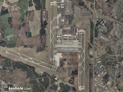
| WASHINGTON DULLES INTL WASHINGTON DC VA |
| |
| Lat: N 3856.8 Long: W 07727.6 Elev: 313 Var: +10 Longest Runway: 11500 | ||
| Clr Del: 135.7 Dept. ATIS: 134.85 Arr. ATIS: 134.85 Ground: 121.9 /121.62 Tower: 120.1/120.25 | ||

| |||||||||||||||||||||||||||||||||||||||||||||||||||||||||||||||||||||
| |||||||||||||||||||||||||||||||||||||||||||||||||||||||||||||||||||||
| |||||||||||||||||||||||||||||||||||||||||||||||||||||||||||||||||||||
| |||||||||||||||||||||||||||||||||||||||||||||||||||||||||||||||||||||
| |||||||||||||||||||||||||||||||||||||||||||||||||||||||||||||||||||||
| FBOs at nearby airports who want your business: | |||||||||||||||||
| |||||||||||||||||
| |||||||||||||||||
| |||||||||||||||||
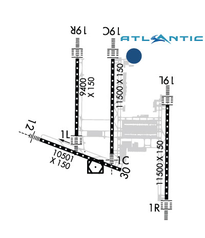
| Rwy | Rwy | |||||||
| 11500x150 | 11500' | 111.30 - 010° | 11500x150 | 11500' | 111.30 - 190° | |||
| 9400x150 | 9400' | 110.75 - 010° | 9400x150 | 9400' | 110.75 - 191° | |||
| 11500x150 | 11500' | 110.10 - 010° | 11500x150 | 11500' | 110.10 - 190° | |||
| 10501x150 | 10501' | 109.30 - 120° | 10501x150 | 10501' | ||||
| Runway ID | Single Wheel | Double Wheel | Double Tandem Wheel | Dual Double Wheel |
| 01C/19C | 200,000 | 250,000 | 450,000 | 875,000 |
| 01L/19R | 200,000 | 250,000 | 450,000 | 875,000 |
| 01R/19L | 200,000 | 250,000 | 450,000 | 875,000 |
| 12/30 | 200,000 | 250,000 | 450,000 | 875,000 |
| These numbers are Advisory and are not limits. The Airport Manager should have more accurate Weight Limits | ||||
 Airport Diagram might not be current. | |
| Facility Name: | WASHINGTON DULLES INTL |
| City Name: | WASHINGTON |
| County: | LOUDOUN; LOCATED IN BOTH FAIRFAX COUNTY VA AND LOUDOUN COUNTY VA. |
| State abbrev: | DC |
| State Name: | DIST. OF COLUMBIA |
| Ownership: | PUBLICLY OWNED |
| Use: | OPEN TO THE PUBLIC |
| Owner's Name: | METRO WASH ARPT AUTHORITY |
| Address: | 1 AVIATION CIRCLE |
| WASHINGTON, DC 20001-6000 | |
| Owner's Phone: | 703-417-8600 |
| Manager's Name: | MIKE STEWART |
| Address: | 1 SAARINEN CIRCLE, SAARINEN CENTER MA-210 |
| DULLES, VA 20166 | |
| Phone: | 703-572-2730 |
| FAA Region: | EASTERN |
| FAA Field Office: | DCA |
| Date | Sunrise | Sunset |
|---|---|---|
| 09/24/21 Friday | 6:59 | 19:04 |
| 09/25/21 Saturday | 7:00 | 19:02 |
| 09/26/21 Sunday | 7:01 | 19:01 |
| 09/27/21 Monday | 7:02 | 18:59 |
| 09/28/21 Tuesday | 7:03 | 18:58 |
| 09/29/21 Wednesday | 7:04 | 18:56 |
| 09/30/21 Thursday | 7:05 | 18:54 |
| 10/01/21 Friday | 7:06 | 18:53 |
| 10/02/21 Saturday | 7:06 | 18:51 |
| 10/03/21 Sunday | 7:07 | 18:50 |
| 10/04/21 Monday | 7:08 | 18:48 |
| 10/05/21 Tuesday | 7:09 | 18:47 |
| 10/06/21 Wednesday | 7:10 | 18:45 |
| 10/07/21 Thursday | 7:11 | 18:44 |
| Airport Attendance Schedule | CONTINUOUS |
| Airport Status | OPERATIONAL (This Status can change at any time - please check NOTAMS) |
| Airport Lighting Schedule | |
| Airport Storage Available | Tie Downs, Hanger |
| Extra Services Available | Air Freight, Avionics, Cargo Handling, Aircraft Sales |
| Wind Indicator | YES - (lighted) |
| Control Tower | YES |
| CTAF Frequency | |
| Unicom Frequency | 122.950 |
| Rotating Beacon Color | CLEAR-GREEN (Light Land Airport) |
| Segmented Circle | NO |
| Landing Fee | YES |
| Airport Inspected | FEDERAL - performed by FAA AIRPORTS FIELD PERSONNEL |
| Inspection Date | 10/13/2020 |
| Type of Fuel Available | Grade 100LL, JET A (freeze point -40C) |
| Airframe Repair Service | MAJOR |
| Power Plant Repair Service | MAJOR |
| Latitude | N3856.8 |
| Longitude | W07727.6 (ESTIMATED) |
| Arpt Elevation | 313ft (SURVEYED) |
| Magnetic Variation | 10W |
| 20 miles W | of WASHINGTON |
| Traffic Pattern Altitude | |
| Sectional Chart | WASHINGTON |
| Operations (Reported) | Yearly | Avg. Daily |
|---|---|---|
| General Aviation Transient | 33470 | 92 |
| General Aviation Local | 0 | 0 |
| Air Taxi | 87816 | 241 |
| Commerical | 169555 | 465 |
| Commuter | 0 | 0 |
| Military | 1120 | 3 |
| Aircraft based on Field | |
|---|---|
| General Aviation Singles | 9 |
| General Aviation Multi | 0 |
| Jet Aircraft | 56 |
| General Aviation Helicopters | 1 |
| Military Aircraft | 0 |
| Gliders | 0 |
| Ultralights | 0 |
| FSS on field | NO |
| FSS tie-in | LEESBURG |
| FSS Phone | 1-800-WX-BRIEF |
| Who issues Notams | IAD |
| Notam D service at airport | YES |
| ARTCC Name | WASHINGTON |
| Airport Certification | AIRPORT RECEIVING SCHEDULED AIR CARRIER SERVICE FROM CARRIERS CERTIFICATED BY THE CIVIL AERONAUTICS BOARD |
| Aircraft Rescue & Firefighting Index | AIRPORT HAS A CERTIFICATE UNDER CFR PART 139 |
| Airport of Entry | No |
| Custom Landing Rights | YES |
| Joint Civil/Military | No |
| Military Landing rights | YES |
| NATIONAL PLAN OF INTEGRATED AIRPORT SYSTEMS (NPIAS) |
| GRANT AGREEMENTS UNDER FAAP/ADAP/AIP |
| COMPLIANCE WITH ACCESSIBILITY TO THE HANDICAPPED |
| SURPLUS PROPERTY AGREEMENT UNDER PUBLIC LAW 289 |
| ASSURANCES PURSUANT TO TITLE VI, CIVIL RIGHTS ACT OF 1964 |
| TAXILANE 'C' ACTIVE; PUSHBACK CLNCS ON NORTH SIDE OF MIDFIELD TERMINAL ARE ONTO TAXILANE 'D' ONLY UNLESS OTHERWISE AUTH. |
| ITNRNT ACFT CTC FBO ON 122.95 OR 129.77 FOR SVCS. |
| ALL AIRCRAFT WITH WINGSPAN EXCEEDING 118 FT ARE RESTRICTED FROM USING TAXILANE A BTN A1 & A5. |
| RUNUP BLX FOR RWY 30 DSGND AS NON-MOVEMENT AREA. |
| ALL 180 DEG TURNS OUT OF APRON POSITIONS SHALL BE MADE USING MINIMUM POWER. |
| LDG FEE. FLIGHT NOTIFICATION SERVICE (ADCUS) AVBL. NOTE: SEE SPECIAL NOTICES --CONTINUOUS POWER FACILITIES. |
| ASDE-X IN USE. OPERATE TRANSPONDERS WITH ALTITUDE REPORTING MODE AND ADS-B (IF EQUIPPED) ENABLED ON ALL AIRPORT SURFACES. |
| TWY E1 RESTRICTED TO ACFT WITH A WINGSPAN LESS THAN 79 FT. |
| B747-8 RESTRICTED TO MAXIMUM TAXI SPEED 17 KTS (20 MPH) ON TWY J. |
| ENGINE RUN-UPS BTW 2200L & 0700L REQUIRE PRIOR APPROVAL FM ARPT OPS. |
| RY 30 DEPARTURES USE UPPER ANTENNA FOR ATC COMMUNICATIONS. |
| RY STATUS LGTS ARE IN OPN. |
| ACR PUSH BACKS & PWR FM ALL APRON PSNS REQUIRE CLNC FM MWAA RAMP TWR. |
| LARGE FLOCKS OF BIRDS ON & INVOF ARPT/DEER INVOF ARPT. |
| DURING PERIODS OF ACFT SATURATION LONG TERM PARKING MAY NOT BE AVAILABLE. SERVICES FOR FUEL AND GO ONLY WILL BE AVAILABLE. |
| FLIGHT TRAINING BETWEEN 2200-0700 IS PROHIBITED. |
Airport Communications & Frequencies:
| |||||||||||||||||||||||||||||||||||||||||||||||||||||||||||||||
| Runway: 01C | Runway: 19C | ||
| Mag heading: | 11° | Mag heading: | 191° |
| Rwy Slope: | -.15% Down | Rwy Slope: | .15% Up |
| Approach: | ILS | Approach: | ILS |
| Pattern: | Left Traffic | Pattern: | Left Traffic |
| Markings: | PRECISION INSTRUMENT | Markings: | PRECISION INSTRUMENT |
| Marking Condition: | GOOD | Marking Condition: | GOOD |
| Arresting Dev: | Arresting Dev: | ||
| Lat & Long: | N3856.3 W07727.6 | Lat. & Long.: | N3858.2 W07727.6 |
| Elev: | 286.1 ft. MSL | Elev: | 268.5 ft. MSL |
| TCH: | 70 ft. AGL | TCH: | 72 ft. AGL |
| Visual Glide Path: | 3.00 degrees | Visual Glide Path: | 3.00 degrees |
| Displaced Threshold: | No | Displaced Threshold: | No |
| Touchdown Zone: | YES | Touchdown Zone: | YES |
| Touchdown Elev.: | 286.3 feet | Touchdown Elev.: | 271.3 feet |
| Visual Glide Slope: | 4-Light PAPI on LEFT side of Runway | Visual Glide Slope: | 4-Light PAPI on RIGHT side of Runway |
| RVR Equipment: | TOUCHDOWN-MIDFIELD-ROLLOUT | RVR Equipment: | TOUCHDOWN-MIDFIELD-ROLLOUT |
| RVV Equipment: | NO | RVV Equipment: | NO |
| Approach Lights: | MALSR - 1,400 foot medium intensity approach lighting system with runway alignment indicator lights | Approach Lights: | ALSF2 - standard 2,400 foot high intensity approach lighting system with sequenced flashers, Category II or III |
| REIL: | NO | REIL: | NO |
| Centerline Lights: | YES | Centerline Lights: | YES |
| Touchdown lights: | YES | Touchdown lights: | YES |
| Runway Category: | Precision Instrument Runway | Runway Category: | Precision Instrument Runway |
| Declared Distances: | TORA:11500' TODA:11500' ASDA:11500' LDA:11500' | Declared Distances: | TORA:11500' TODA:11500' ASDA:11500' LDA:11089' |
| Runway: 01L | Runway: 19R | ||
| Mag heading: | 11° | Mag heading: | 191° |
| Rwy Slope: | -.20% Down | Rwy Slope: | .20% Up |
| Approach: | ILS/DME | Approach: | ILS/DME |
| Pattern: | Left Traffic | Pattern: | Left Traffic |
| Markings: | PRECISION INSTRUMENT | Markings: | PRECISION INSTRUMENT |
| Marking Condition: | GOOD | Marking Condition: | GOOD |
| Arresting Dev: | Arresting Dev: | ||
| Lat & Long: | N3856.7 W07728.5 | Lat. & Long.: | N3858.2 W07728.5 |
| Elev: | 296.0 ft. MSL | Elev: | 276.9 ft. MSL |
| TCH: | 70 ft. AGL | TCH: | 70 ft. AGL |
| Visual Glide Path: | 3.00 degrees | Visual Glide Path: | 3.00 degrees |
| Displaced Threshold: | No | Displaced Threshold: | No |
| Touchdown Zone: | YES | Touchdown Zone: | YES |
| Touchdown Elev.: | 296.1 feet | Touchdown Elev.: | 278.4 feet |
| Visual Glide Slope: | 4-Light PAPI on LEFT side of Runway | Visual Glide Slope: | 4-Light PAPI on LEFT side of Runway |
| RVR Equipment: | TOUCHDOWN-MIDFIELD-ROLLOUT | RVR Equipment: | TOUCHDOWN-MIDFIELD-ROLLOUT |
| RVV Equipment: | NO | RVV Equipment: | NO |
| Approach Lights: | ALSF2 - standard 2,400 foot high intensity approach lighting system with sequenced flashers, Category II or III | Approach Lights: | ALSF2 - standard 2,400 foot high intensity approach lighting system with sequenced flashers, Category II or III |
| REIL: | NO | REIL: | NO |
| Centerline Lights: | YES | Centerline Lights: | YES |
| Touchdown lights: | YES | Touchdown lights: | YES |
| Runway Category: | Precision Instrument Runway | Runway Category: | Precision Instrument Runway |
| Declared Distances: | TORA:9400' TODA:9400' ASDA:9400' LDA:9400' | Declared Distances: | TORA:9400' TODA:9400' ASDA:9400' LDA:9400' |
| Runway: 01R | Runway: 19L | ||
| Mag heading: | 11° | Mag heading: | 191° |
| Rwy Slope: | -.16% Down | Rwy Slope: | .16% Up |
| Approach: | ILS/DME | Approach: | ILS/DME |
| Pattern: | Left Traffic | Pattern: | Left Traffic |
| Markings: | PRECISION INSTRUMENT | Markings: | PRECISION INSTRUMENT |
| Marking Condition: | GOOD | Marking Condition: | GOOD |
| Arresting Dev: | Arresting Dev: | ||
| Lat & Long: | N3855.4 W07726.2 | Lat. & Long.: | N3857.3 W07726.2 |
| Elev: | 311.7 ft. MSL | Elev: | 293.2 ft. MSL |
| TCH: | 72 ft. AGL | TCH: | 75 ft. AGL |
| Visual Glide Path: | 3.00 degrees | Visual Glide Path: | 3.00 degrees |
| Displaced Threshold: | No | Displaced Threshold: | No |
| Touchdown Zone: | YES | Touchdown Zone: | YES |
| Touchdown Elev.: | 312.4 feet | Touchdown Elev.: | 302.2 feet |
| Visual Glide Slope: | 4-Light PAPI on RIGHT side of Runway | Visual Glide Slope: | 4-Light PAPI on LEFT side of Runway |
| RVR Equipment: | TOUCHDOWN-MIDFIELD-ROLLOUT | RVR Equipment: | TOUCHDOWN-MIDFIELD-ROLLOUT |
| RVV Equipment: | NO | RVV Equipment: | NO |
| Approach Lights: | ALSF2 - standard 2,400 foot high intensity approach lighting system with sequenced flashers, Category II or III | Approach Lights: | ALSF2 - standard 2,400 foot high intensity approach lighting system with sequenced flashers, Category II or III |
| REIL: | NO | REIL: | NO |
| Centerline Lights: | YES | Centerline Lights: | YES |
| Touchdown lights: | YES | Touchdown lights: | NO |
| Runway Category: | Precision Instrument Runway | Runway Category: | Precision Instrument Runway |
| Declared Distances: | TORA:11500' TODA:11500' ASDA:11500' LDA:11500' | Declared Distances: | TORA:11500' TODA:11500' ASDA:11500' LDA:11500' |
| Obstructions: | Obstructions: | POLE | |
| Marked: | Marked: | NOT Marked/Lighted | |
| Clearance slope: | 50:1 | Clearance slope: | 44:1 |
| Obstruction height: | Obstruction height: | 38 feet AGL | |
| Dist. from runway: | Dist. from runway: | 1900 feet | |
| Centerline offset: | Centerline offset: | 720 feet right of centerline | |
| Comments: | Comments: |
| Runway: 12 | Runway: 30 | ||
| Mag heading: | 121° | Mag heading: | 301° |
| Rwy Slope: | -.21% Down | Rwy Slope: | .21% Up |
| Approach: | ILS | Approach: | |
| Pattern: | Left Traffic | Pattern: | Left Traffic |
| Markings: | PRECISION INSTRUMENT | Markings: | PRECISION INSTRUMENT |
| Marking Condition: | GOOD | Marking Condition: | GOOD |
| Arresting Dev: | Arresting Dev: | ||
| Lat & Long: | N3856.6 W07729.4 | Lat. & Long.: | N3856.0 W07727.4 |
| Elev: | 309.8 ft. MSL | Elev: | 287.8 ft. MSL |
| TCH: | 66 ft. AGL | TCH: | 84 ft. AGL |
| Visual Glide Path: | 3.00 degrees | Visual Glide Path: | 3.00 degrees |
| Displaced Threshold: | No | Displaced Threshold: | No |
| Touchdown Zone: | YES | Touchdown Zone: | YES |
| Touchdown Elev.: | 309.8 feet | Touchdown Elev.: | 287.8 feet |
| Visual Glide Slope: | 4-Light PAPI on RIGHT side of Runway | Visual Glide Slope: | 4-Light PAPI on LEFT side of Runway |
| RVR Equipment: | TOUCHDOWN-ROLLOUT | RVR Equipment: | TOUCHDOWN-ROLLOUT |
| RVV Equipment: | NO | RVV Equipment: | NO |
| Approach Lights: | MALSR - 1,400 foot medium intensity approach lighting system with runway alignment indicator lights | Approach Lights: | |
| REIL: | NO | REIL: | YES |
| Centerline Lights: | YES | Centerline Lights: | YES |
| Touchdown lights: | YES | Touchdown lights: | NO |
| Runway Category: | Precision Instrument Runway | Runway Category: | Runway with a Visual Approach |
| Declared Distances: | TORA:10501' TODA:10501' ASDA:10501' LDA:10501' | Declared Distances: | TORA:10501' TODA:10501' ASDA:10501' LDA:10501' |
Thanks for using FltPlan.com
all rights reserved © 1999-2021 by Flight Plan LLC