
| GRIMES FIELD URBANA OH |
| |
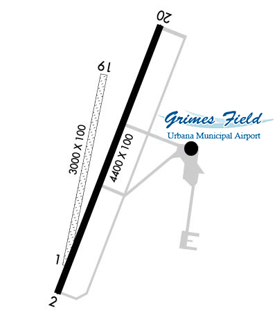
| Lat: N 4007.9 Long: W 08345.2 Elev: 1068 Var: +04 Longest Runway: 4400 | ||
| AWOS: 118.32 CTAF: 122.7 | ||
| ||||||||||||||||||||||||||||||||||||||||||||||||||||||||||||||||||||
| ||||||||||||||||||||||||||||||||||||||||||||||||||||||||||||||||||||
| ||||||||||||||||||||||||||||||||||||||||||||||||||||||||||||||||||||
| Rwy | Rwy | |||||||
| 3000x100 | 3000' | 3000x100 | 3000' | |||||
| 4400x100 | 4400' | 4400x100 | 4400' | |||||
| Runway ID | Single Wheel | Double Wheel | Double Tandem Wheel | Dual Double Wheel |
| 01/19 | N/A | N/A | N/A | N/A |
| 02/20 | N/A | N/A | N/A | N/A |
| These numbers are Advisory and are not limits. The Airport Manager should have more accurate Weight Limits | ||||
 Airport Diagram might not be current. | |
| Facility Name: | GRIMES FLD |
| City Name: | URBANA |
| County: | CHAMPAIGN |
| State abbrev: | OH |
| State Name: | OHIO |
| Ownership: | PUBLICLY OWNED |
| Use: | OPEN TO THE PUBLIC |
| Owner's Name: | CITY OF URBANA |
| Address: | 205 S MAIN ST |
| URBANA, OH 43078-2113 | |
| Owner's Phone: | 937-652-4304 |
| Manager's Name: | DRAKE HUFFMAN |
| Address: | 1636 N MAIN ST |
| URBANA, OH 43078-5001 | |
| Phone: | 937-652-4319; CELL 740-995-9919. |
| FAA Region: | GREAT LAKES |
| FAA Field Office: | DET |
| Date | Sunrise | Sunset |
|---|---|---|
| 06/08/26 Monday | 6:06 | 21:03 |
| 06/09/26 Tuesday | 6:06 | 21:03 |
| 06/10/26 Wednesday | 6:05 | 21:04 |
| 06/11/26 Thursday | 6:05 | 21:04 |
| 06/12/26 Friday | 6:05 | 21:05 |
| 06/13/26 Saturday | 6:05 | 21:05 |
| 06/14/26 Sunday | 6:05 | 21:05 |
| 06/15/26 Monday | 6:05 | 21:06 |
| 06/16/26 Tuesday | 6:05 | 21:06 |
| 06/17/26 Wednesday | 6:05 | 21:07 |
| 06/18/26 Thursday | 6:05 | 21:07 |
| 06/19/26 Friday | 6:05 | 21:07 |
| 06/20/26 Saturday | 6:06 | 21:07 |
| 06/21/26 Sunday | 6:06 | 21:08 |
| Airport Attendance Schedule | MON-FRI 0800-1600; UNATNDD MAJOR HOLS. |
| Airport Status | OPERATIONAL (This Status can change at any time - please check NOTAMS) |
| Airport Lighting Schedule | ACTVT REIL RWY 02 & 20; MIRL RWY 02/20 - CTAF. |
| Airport Storage Available | Tie Downs, Hanger |
| Extra Services Available | Crop Dusting, Air Ambulance, Charter, Flight Instruction |
| Wind Indicator | YES - (lighted) |
| Control Tower | NO |
| CTAF Frequency | 122.700 |
| Unicom Frequency | 122.700 |
| Rotating Beacon Color | WG |
| Segmented Circle | NO |
| Landing Fee | YES; LDG FEE FOR ACFT WITH MAX LDG WT 6000 LB OR GTR - WAIVED WITH MNM FUEL PURCHASE. |
| Airport Inspected | STATE - performed by STATE AERONAUTICAL PERSONNEL |
| Inspection Date | 08/01/2025 |
| Type of Fuel Available | Grade 100LL, JET A; -10100LL & JET A+ AVBL H24 SELF SVC VIA CREDIT CARD. |
| Airframe Repair Service | MINOR |
| Power Plant Repair Service | MINOR |
| Latitude | N4007.9 |
| Longitude | W08345.2 (ESTIMATED) |
| Arpt Elevation | 1067ft (SURVEYED) |
| Magnetic Variation | 04W |
| 1 miles N | of URBANA |
| Traffic Pattern Altitude | |
| Sectional Chart | DETROIT |
| Operations (Reported) | Yearly | Avg. Daily |
|---|---|---|
| General Aviation Transient | 0 | 0 |
| General Aviation Local | 0 | 0 |
| Air Taxi | 0 | 0 |
| Commerical | 0 | 0 |
| Commuter | 0 | 0 |
| Military | 0 | 0 |
| Aircraft based on Field | |
|---|---|
| General Aviation Singles | 0 |
| General Aviation Multi | 0 |
| Jet Aircraft | 0 |
| General Aviation Helicopters | 0 |
| Military Aircraft | 0 |
| Gliders | 0 |
| Ultralights | 0 |
| FSS on field | NO |
| FSS tie-in | DAYTON |
| FSS Phone | 1-800-WX-BRIEF |
| Who issues Notams | I74 |
| Notam D service at airport | YES |
| ARTCC Name | INDIANAPOLIS |
| Airport Certification | |
| Aircraft Rescue & Firefighting Index | None |
| Airport of Entry | No |
| Custom Landing Rights | No |
| Joint Civil/Military | No |
| Military Landing rights | YES |
| NATIONAL PLAN OF INTEGRATED AIRPORT SYSTEMS (NPIAS) |
| GRANT AGREEMENTS UNDER FAAP/ADAP/AIP |
| ASSURANCES PURSUANT TO TITLE VI, CIVIL RIGHTS ACT OF 1964 |
| FOR CD CTC COLUMBUS APCH AT 614-338-8537. |
| BIRDS & DEER ON & INVOF ARPT. |
| 125 FT WATER TWR, 1 NM SOUTH. |
| RWY 20 CALM WIND RWY. |
Airport Communications & Frequencies:
| ||||||||||||||
| Runway: 01 | Runway: 19 | ||
| Mag heading: | 12° | Mag heading: | 192° |
| Rwy Slope: | .00% | Rwy Slope: | .00% |
| Approach: | Approach: | ||
| Pattern: | Left Traffic | Pattern: | Left Traffic |
| Markings: | Markings: | ||
| Marking Condition: | GOOD; YELLOW CONES. | Marking Condition: | GOOD; YELLOW CONES. |
| Arresting Dev: | Arresting Dev: | ||
| Lat & Long: | N4007.7 W08345.3 | Lat. & Long.: | N4008.2 W08345.2 |
| Elev: | 1060.0 ft. MSL | Elev: | 1060.0 ft. MSL |
| TCH: | TCH: | ||
| Visual Glide Path: | Visual Glide Path: | ||
| Displaced Threshold: | No | Displaced Threshold: | No |
| Touchdown Zone: | NO | Touchdown Zone: | NO |
| Touchdown Elev.: | Touchdown Elev.: | ||
| Visual Glide Slope: | Visual Glide Slope: | ||
| RVR Equipment: | RVR Equipment: | ||
| RVV Equipment: | NO | RVV Equipment: | NO |
| Approach Lights: | Approach Lights: | ||
| REIL: | NO | REIL: | NO |
| Centerline Lights: | NO | Centerline Lights: | NO |
| Touchdown lights: | NO | Touchdown lights: | NO |
| Runway Category: | Runway with a Visual Approach | Runway Category: | Runway with a Visual Approach |
| Declared Distances: | Declared Distances: |
| Runway: 02 | Runway: 20 | ||
| Mag heading: | 22° | Mag heading: | 202° |
| Rwy Slope: | .22% Up | Rwy Slope: | -.22% Down |
| Approach: | Approach: | ||
| Pattern: | Left Traffic | Pattern: | Left Traffic |
| Markings: | NONPRECISION INSTRUMENT | Markings: | NONPRECISION INSTRUMENT |
| Marking Condition: | FAIR | Marking Condition: | FAIR |
| Arresting Dev: | Arresting Dev: | ||
| Lat & Long: | N4007.6 W08345.4 | Lat. & Long.: | N4008.3 W08345.1 |
| Elev: | 1057.8 ft. MSL | Elev: | 1067.5 ft. MSL |
| TCH: | 44 ft. AGL | TCH: | 38 ft. AGL |
| Visual Glide Path: | 3.00 degrees | Visual Glide Path: | 3.00 degrees |
| Displaced Threshold: | No | Displaced Threshold: | No |
| Touchdown Zone: | YES | Touchdown Zone: | YES |
| Touchdown Elev.: | 1067.7 feet | Touchdown Elev.: | 1067.9 feet |
| Visual Glide Slope: | 4-Light PAPI on RIGHT side of Runway | Visual Glide Slope: | 4-Light PAPI on LEFT side of Runway |
| RVR Equipment: | RVR Equipment: | ||
| RVV Equipment: | NO | RVV Equipment: | NO |
| Approach Lights: | Approach Lights: | ||
| REIL: | YES | REIL: | YES |
| Centerline Lights: | NO | Centerline Lights: | NO |
| Touchdown lights: | NO | Touchdown lights: | NO |
| Runway Category: | Runway with a Non-precision Approach | Runway Category: | Runway with a Non-precision Approach |
| Declared Distances: | Declared Distances: |
Thanks for using FltPlan.com
all rights reserved © 1999-2026 by Flight Plan LLC


