
| MORGAN COUNTY MC CONNELSVILLE OH |
| |
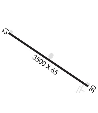
| Lat: N 3939.3 Long: W 08148.2 Elev: 1000 Var: +06 Longest Runway: 3500 | ||
| CTAF: 122.8 | ||
| ||||||||||||||||||||||||||||||||||||||||||||
| ||||||||||||||||||||||||||||||||||||||||||||
| Rwy | Rwy | |||||||
| 3500x65 | 3150' | 3500x65 | 3500' | |||||
| Runway ID | Single Wheel | Double Wheel | Double Tandem Wheel | Dual Double Wheel |
| 12/30 | 12,000 | N/A | N/A | N/A |
| These numbers are Advisory and are not limits. The Airport Manager should have more accurate Weight Limits | ||||
| FltPlan does not have IFR approach charts available for KI71. |
 Airport Diagram might not be current. | |
| Facility Name: | MORGAN COUNTY |
| City Name: | MC CONNELSVILLE |
| County: | MORGAN |
| State abbrev: | OH |
| State Name: | OHIO |
| Ownership: | PUBLICLY OWNED |
| Use: | OPEN TO THE PUBLIC |
| Owner's Name: | MORGAN COUNTY AIRPORT AUTH |
| Address: | 995 E AIRPORT RD NE |
| MCCONNELSVILLE, OH 43756-9323 | |
| Owner's Phone: | 334-447-0624 |
| Manager's Name: | KURT JOHNSON |
| Address: | 995 E AIRPORT RD NE |
| MCCONNELLSVILLE, OH 43756-9323 | |
| Phone: | 334-447-0624; EMERG TEL 740-962-3333-SHERIFF OFC. |
| FAA Region: | GREAT LAKES |
| FAA Field Office: | DET |
| Date | Sunrise | Sunset |
|---|---|---|
| 06/08/26 Monday | 5:59 | 20:53 |
| 06/09/26 Tuesday | 5:59 | 20:54 |
| 06/10/26 Wednesday | 5:59 | 20:54 |
| 06/11/26 Thursday | 5:59 | 20:55 |
| 06/12/26 Friday | 5:59 | 20:55 |
| 06/13/26 Saturday | 5:59 | 20:56 |
| 06/14/26 Sunday | 5:59 | 20:56 |
| 06/15/26 Monday | 5:59 | 20:57 |
| 06/16/26 Tuesday | 5:59 | 20:57 |
| 06/17/26 Wednesday | 5:59 | 20:57 |
| 06/18/26 Thursday | 5:59 | 20:58 |
| 06/19/26 Friday | 5:59 | 20:58 |
| 06/20/26 Saturday | 5:59 | 20:58 |
| 06/21/26 Sunday | 6:00 | 20:58 |
| Airport Attendance Schedule | UNATTENDED |
| Airport Status | OPERATIONAL (This Status can change at any time - please check NOTAMS) |
| Airport Lighting Schedule | ACTVT MIRL RWY 12/30 - CTAF. |
| Airport Storage Available | Tie Downs, Hanger |
| Extra Services Available | NONE |
| Wind Indicator | YES - (lighted) |
| Control Tower | NO |
| CTAF Frequency | 122.800 |
| Unicom Frequency | 122.800 |
| Rotating Beacon Color | WG |
| Segmented Circle | NO |
| Landing Fee | NO |
| Airport Inspected | STATE - performed by STATE AERONAUTICAL PERSONNEL |
| Inspection Date | 10/03/2024 |
| Type of Fuel Available | Grade 100LL; -10FOR FUEL REFER TO LIST IN ADMIN BLDG. |
| Airframe Repair Service | NONE |
| Power Plant Repair Service | NONE |
| Latitude | N3939.3 |
| Longitude | W08148.2 (ESTIMATED) |
| Arpt Elevation | 1000ft (ESTIMATED) |
| Magnetic Variation | 06W |
| 3 miles E | of MC CONNELSVILLE |
| Traffic Pattern Altitude | 800 |
| Sectional Chart | CINCINNATI |
| Operations (Reported) | Yearly | Avg. Daily |
|---|---|---|
| General Aviation Transient | 0 | 0 |
| General Aviation Local | 0 | 0 |
| Air Taxi | 0 | 0 |
| Commerical | 0 | 0 |
| Commuter | 0 | 0 |
| Military | 0 | 0 |
| Aircraft based on Field | |
|---|---|
| General Aviation Singles | 0 |
| General Aviation Multi | 0 |
| Jet Aircraft | 0 |
| General Aviation Helicopters | 0 |
| Military Aircraft | 0 |
| Gliders | 0 |
| Ultralights | 0 |
| FSS on field | NO |
| FSS tie-in | CLEVELAND |
| FSS Phone | 1-800-WX-BRIEF |
| Who issues Notams | CLE |
| Notam D service at airport | YES |
| ARTCC Name | INDIANAPOLIS |
| Airport Certification | |
| Aircraft Rescue & Firefighting Index | None |
| Airport of Entry | No |
| Custom Landing Rights | No |
| Joint Civil/Military | No |
| Military Landing rights | No |
| DEER ON & INVOF ARPT. |
| FOR CD CTC INDIANAPOLIS ARTCC AT 317-247-2411. |
| Runway: 12 | Runway: 30 | ||
| Mag heading: | 125° | Mag heading: | 305° |
| Rwy Slope: | .00% | Rwy Slope: | .00% |
| Approach: | Approach: | ||
| Pattern: | Left Traffic | Pattern: | Left Traffic |
| Markings: | BASIC | Markings: | BASIC |
| Marking Condition: | GOOD | Marking Condition: | GOOD |
| Arresting Dev: | Arresting Dev: | ||
| Lat & Long: | N3939.4 W08148.5 | Lat. & Long.: | N3939.1 W08147.9 |
| Elev: | 1000.0 ft. MSL | Elev: | 1000.0 ft. MSL |
| TCH: | TCH: | ||
| Visual Glide Path: | Visual Glide Path: | ||
| Displaced Threshold: | 350 feet | Displaced Threshold: | No |
| Touchdown Zone: | NO | Touchdown Zone: | NO |
| Touchdown Elev.: | Touchdown Elev.: | ||
| Visual Glide Slope: | Visual Glide Slope: | ||
| RVR Equipment: | RVR Equipment: | ||
| RVV Equipment: | NO | RVV Equipment: | NO |
| Approach Lights: | Approach Lights: | ||
| REIL: | NO | REIL: | NO |
| Centerline Lights: | NO | Centerline Lights: | NO |
| Touchdown lights: | NO | Touchdown lights: | NO |
| Runway Category: | Runway with a Visual Approach | Runway Category: | Runway with a Visual Approach |
| Declared Distances: | Declared Distances: | ||
| Obstructions: | ROAD | Obstructions: | HILL |
| Marked: | LIGHTED | Marked: | NOT Marked/Lighted |
| Clearance slope: | 1:1; APCH SLP 0:1 TO DTHR OVR 20 FT HILL, 0 FT DIST, 96 FT L. | Clearance slope: | 8:1; ALSO APCH SLP 17:1 OVR 74 FT TREES, 1527 FT DIST, 62 FT R. |
| Obstruction height: | 25 feet AGL | Obstruction height: | 6 feet AGL |
| Dist. from runway: | 225 feet | Dist. from runway: | 250 feet |
| Centerline offset: | 125 left of centerline | Centerline offset: | 125 feet right of centerline |
| Comments: | +12 FT TRRN, 0 FT DIST, 125 FT L. | Comments: | +7 FT TRRN, 0 FT DIST, 125 FT R. |
Thanks for using FltPlan.com
all rights reserved © 1999-2026 by Flight Plan LLC
