| CLINTON FIELD WILMINGTON OH |
| |
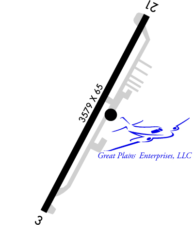
| Lat: N 3930.1 Long: W 08351.8 Elev: 1033 Var: +05 Longest Runway: 3579 | ||
| CTAF: 122.72 | ||
| |||||||||||||||||||||||||||||||||||||||||||||||||||||||||||||
| |||||||||||||||||||||||||||||||||||||||||||||||||||||||||||||
| |||||||||||||||||||||||||||||||||||||||||||||||||||||||||||||
| Rwy | Rwy | |||||||
| 3579x60 | 3579' | 3579x60 | 3579' | |||||
| Runway ID | Single Wheel | Double Wheel | Double Tandem Wheel | Dual Double Wheel |
| 03/21 | 12,500 | N/A | N/A | N/A |
| These numbers are Advisory and are not limits. The Airport Manager should have more accurate Weight Limits | ||||
 Airport Diagram might not be current. | |
| Facility Name: | CLINTON FLD |
| City Name: | WILMINGTON |
| County: | CLINTON |
| State abbrev: | OH |
| State Name: | OHIO |
| Ownership: | PUBLICLY OWNED |
| Use: | OPEN TO THE PUBLIC |
| Owner's Name: | CLINTON CO BOARD OF COMM |
| Address: | 1850 DAVIDS DR STE 208 |
| WILMINGTON, OH 45177-7205 | |
| Owner's Phone: | 937-382-2103 |
| Manager's Name: | MELODY WALDMANN; CLINTONCOUNTYAIRPORT@YAHOO.COM. |
| Address: | 1581 N CURRY RD |
| WILMINGTON, OH 45177-9048 | |
| Phone: | 937-382-4638; CELL 937-725-1946. |
| FAA Region: | GREAT LAKES |
| FAA Field Office: | DET |
| Date | Sunrise | Sunset |
|---|---|---|
| 06/08/26 Monday | 6:08 | 21:01 |
| 06/09/26 Tuesday | 6:08 | 21:02 |
| 06/10/26 Wednesday | 6:08 | 21:02 |
| 06/11/26 Thursday | 6:08 | 21:03 |
| 06/12/26 Friday | 6:08 | 21:03 |
| 06/13/26 Saturday | 6:08 | 21:03 |
| 06/14/26 Sunday | 6:08 | 21:04 |
| 06/15/26 Monday | 6:08 | 21:04 |
| 06/16/26 Tuesday | 6:08 | 21:05 |
| 06/17/26 Wednesday | 6:08 | 21:05 |
| 06/18/26 Thursday | 6:08 | 21:05 |
| 06/19/26 Friday | 6:08 | 21:06 |
| 06/20/26 Saturday | 6:08 | 21:06 |
| 06/21/26 Sunday | 6:08 | 21:06 |
| Airport Attendance Schedule | UNATTENDED |
| Airport Status | OPERATIONAL (This Status can change at any time - please check NOTAMS) |
| Airport Lighting Schedule | ACTVT MIRL RWY 03/21 - CTAF. PAPI RWY 03 & 21 OPR CONSLY. |
| Airport Storage Available | Tie Downs, Hanger |
| Extra Services Available | Flight Instruction, Aircraft Rental |
| Wind Indicator | YES - (lighted) |
| Control Tower | NO |
| CTAF Frequency | 122.725 |
| Unicom Frequency | 122.725 |
| Rotating Beacon Color | WG |
| Segmented Circle | NO |
| Landing Fee | NO |
| Airport Inspected | STATE - performed by STATE AERONAUTICAL PERSONNEL |
| Inspection Date | 09/26/2025 |
| Type of Fuel Available | Grade 100LL; -10AVBL SELF SVC VIA CREDIT CARD ONLY. |
| Airframe Repair Service | NONE |
| Power Plant Repair Service | NONE |
| Latitude | N3930.1 |
| Longitude | W08351.8 (ESTIMATED) |
| Arpt Elevation | 1033ft (SURVEYED) |
| Magnetic Variation | 05W |
| 4 miles NW | of WILMINGTON |
| Traffic Pattern Altitude | |
| Sectional Chart | CINCINNATI |
| Operations (Reported) | Yearly | Avg. Daily |
|---|---|---|
| General Aviation Transient | 0 | 0 |
| General Aviation Local | 0 | 0 |
| Air Taxi | 0 | 0 |
| Commerical | 0 | 0 |
| Commuter | 0 | 0 |
| Military | 0 | 0 |
| Aircraft based on Field | |
|---|---|
| General Aviation Singles | 0 |
| General Aviation Multi | 0 |
| Jet Aircraft | 0 |
| General Aviation Helicopters | 0 |
| Military Aircraft | 0 |
| Gliders | 0 |
| Ultralights | 0 |
| FSS on field | NO |
| FSS tie-in | DAYTON |
| FSS Phone | 1-800-WX-BRIEF |
| Who issues Notams | DAY |
| Notam D service at airport | YES |
| ARTCC Name | INDIANAPOLIS |
| Airport Certification | |
| Aircraft Rescue & Firefighting Index | None |
| Airport of Entry | No |
| Custom Landing Rights | No |
| Joint Civil/Military | No |
| Military Landing rights | No |
| NATIONAL PLAN OF INTEGRATED AIRPORT SYSTEMS (NPIAS) |
| DEER & BIRDS ON & INVOF ARPT. |
| FOR CD CTC COLUMBUS APCH AT 614-338-8537. |
Airport Communications & Frequencies:
| ||||||||||||||
| Runway: 03 | Runway: 21 | ||
| Mag heading: | 33° | Mag heading: | 213° |
| Rwy Slope: | .15% Up | Rwy Slope: | -.15% Down |
| Approach: | Approach: | ||
| Pattern: | Left Traffic | Pattern: | Left Traffic |
| Markings: | NONPRECISION INSTRUMENT | Markings: | NONPRECISION INSTRUMENT |
| Marking Condition: | GOOD | Marking Condition: | GOOD |
| Arresting Dev: | Arresting Dev: | ||
| Lat & Long: | N3929.9 W08352.0 | Lat. & Long.: | N3930.4 W08351.6 |
| Elev: | 1025.2 ft. MSL | Elev: | 1030.7 ft. MSL |
| TCH: | 35 ft. AGL | TCH: | 32 ft. AGL |
| Visual Glide Path: | 3.00 degrees | Visual Glide Path: | 3.75 degrees |
| Displaced Threshold: | No | Displaced Threshold: | No |
| Touchdown Zone: | YES | Touchdown Zone: | YES |
| Touchdown Elev.: | 1033.1 feet | Touchdown Elev.: | 1033.1 feet |
| Visual Glide Slope: | 2-Light PAPI on LEFT side of Runway | Visual Glide Slope: | 2-Light PAPI on LEFT side of Runway |
| RVR Equipment: | RVR Equipment: | ||
| RVV Equipment: | NO | RVV Equipment: | NO |
| Approach Lights: | Approach Lights: | ||
| REIL: | NO | REIL: | NO |
| Centerline Lights: | NO | Centerline Lights: | NO |
| Touchdown lights: | NO | Touchdown lights: | NO |
| Runway Category: | Runway with a Non-precision Approach | Runway Category: | Runway with a Non-precision Approach |
| Declared Distances: | Declared Distances: | ||
| Obstructions: | TREES | Obstructions: | TREE |
| Marked: | NOT Marked/Lighted | Marked: | NOT Marked/Lighted |
| Clearance slope: | 4:1 | Clearance slope: | 2:1 |
| Obstruction height: | 55 feet AGL | Obstruction height: | 30 feet AGL |
| Dist. from runway: | 460 feet | Dist. from runway: | 281 feet |
| Centerline offset: | 256 right of centerline | Centerline offset: | 250 feet left of centerline |
| Comments: | Comments: | +70 FT TREE, 94 FT DIST, 220 FT L. |
Thanks for using FltPlan.com
all rights reserved © 1999-2026 by Flight Plan LLC