
| WAKEMAN WAKEMAN OH |
| |
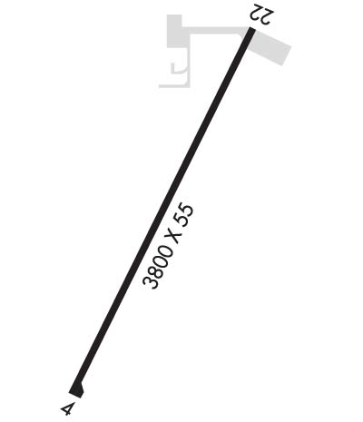
| Lat: N 4117.6 Long: W 08222.3 Elev: 848 Var: +06 Longest Runway: 3800 | ||
| CTAF: 122.8 | ||
| ||||||||||||||||||||||||||||||||||||||||||||
| ||||||||||||||||||||||||||||||||||||||||||||
| Rwy | Rwy | |||||||
| 3800x55 | 3800' | 3800x55 | 3800' | |||||
| Runway ID | Single Wheel | Double Wheel | Double Tandem Wheel | Dual Double Wheel |
| 04/22 | N/A | N/A | N/A | N/A |
| These numbers are Advisory and are not limits. The Airport Manager should have more accurate Weight Limits | ||||
| FltPlan does not have IFR approach charts available for KI64. |
 Airport Diagram might not be current. | |
| Facility Name: | ORTNER |
| City Name: | WAKEMAN |
| County: | ERIE |
| State abbrev: | OH |
| State Name: | OHIO |
| Ownership: | PRIVATELY OWNED |
| Use: | OPEN TO THE PUBLIC |
| Owner's Name: | COURTNEY ORTNER |
| Address: | 10715 STATE ROUTE 60 |
| WAKEMAN, OH 44889-9059 | |
| Owner's Phone: | 440-839-1935 |
| Manager's Name: | COURTNEY ORTNER |
| Address: | 9620 STATE ROUTE 60 |
| WAKEMAN, OH 44889-9236 | |
| Phone: | 440-965-7787; OTR 440-960-6911. |
| FAA Region: | GREAT LAKES |
| FAA Field Office: | DET |
| Date | Sunrise | Sunset |
|---|---|---|
| 06/08/26 Monday | 5:56 | 21:01 |
| 06/09/26 Tuesday | 5:56 | 21:01 |
| 06/10/26 Wednesday | 5:56 | 21:02 |
| 06/11/26 Thursday | 5:56 | 21:02 |
| 06/12/26 Friday | 5:56 | 21:03 |
| 06/13/26 Saturday | 5:56 | 21:03 |
| 06/14/26 Sunday | 5:56 | 21:04 |
| 06/15/26 Monday | 5:56 | 21:04 |
| 06/16/26 Tuesday | 5:56 | 21:05 |
| 06/17/26 Wednesday | 5:56 | 21:05 |
| 06/18/26 Thursday | 5:56 | 21:05 |
| 06/19/26 Friday | 5:56 | 21:06 |
| 06/20/26 Saturday | 5:56 | 21:06 |
| 06/21/26 Sunday | 5:56 | 21:06 |
| Airport Attendance Schedule | MON-SAT 0800-DUSK, SUN 0900-1700 |
| Airport Status | OPERATIONAL (This Status can change at any time - please check NOTAMS) |
| Airport Lighting Schedule | ACTVT NSTD LIRL RWY 04/22 - CTAF. |
| Airport Storage Available | Hanger |
| Extra Services Available | Glider, Glider Towing |
| Wind Indicator | YES - (unlit) |
| Control Tower | NO |
| CTAF Frequency | 122.800 |
| Unicom Frequency | 122.800 |
| Rotating Beacon Color | |
| Segmented Circle | NO |
| Landing Fee | NO |
| Airport Inspected | STATE - performed by STATE AERONAUTICAL PERSONNEL |
| Inspection Date | 07/17/2025 |
| Type of Fuel Available | Grade 100LL |
| Airframe Repair Service | MAJOR |
| Power Plant Repair Service | MAJOR |
| Latitude | N4117.6 |
| Longitude | W08222.3 (ESTIMATED) |
| Arpt Elevation | 848ft (SURVEYED) |
| Magnetic Variation | 06W |
| 3 miles NE | of WAKEMAN |
| Traffic Pattern Altitude | |
| Sectional Chart | DETROIT |
| Operations (Reported) | Yearly | Avg. Daily |
|---|---|---|
| General Aviation Transient | 0 | 0 |
| General Aviation Local | 0 | 0 |
| Air Taxi | 0 | 0 |
| Commerical | 0 | 0 |
| Commuter | 0 | 0 |
| Military | 0 | 0 |
| Aircraft based on Field | |
|---|---|
| General Aviation Singles | 0 |
| General Aviation Multi | 0 |
| Jet Aircraft | 0 |
| General Aviation Helicopters | 0 |
| Military Aircraft | 0 |
| Gliders | 0 |
| Ultralights | 0 |
| FSS on field | NO |
| FSS tie-in | CLEVELAND |
| FSS Phone | 1-800-WX-BRIEF |
| Who issues Notams | CLE |
| Notam D service at airport | YES |
| ARTCC Name | CLEVELAND |
| Airport Certification | |
| Aircraft Rescue & Firefighting Index | None |
| Airport of Entry | No |
| Custom Landing Rights | No |
| Joint Civil/Military | No |
| Military Landing rights | No |
| DEER, BIRDS, & OTR WILDLIFE ON & INVOF ARPT. |
| GLDR ACT ON & INVOF ARPT. |
| RWY 04/2 2 NSTD LIRL DUE TO LGTS 28 FT FM RWY EDGE; UNLGTD 134 FT FM AER 22. |
| Runway: 04 | Runway: 22 | ||
| Mag heading: | 35° | Mag heading: | 215° |
| Rwy Slope: | .00% | Rwy Slope: | .00% |
| Approach: | Approach: | ||
| Pattern: | Left Traffic | Pattern: | Left Traffic |
| Markings: | NONSTANDARD | Markings: | NONSTANDARD |
| Marking Condition: | FAIR; NSTD BASIC DUE TO RWY NR DSPLCD 338 FT FM THR. | Marking Condition: | FAIR; NSTD BASIC DUE TO RWY NR DSPLCD 210 FT FM THR. |
| Arresting Dev: | Arresting Dev: | ||
| Lat & Long: | N4117.3 W08222.5 | Lat. & Long.: | N4117.9 W08222.1 |
| Elev: | 848.0 ft. MSL | Elev: | 848.0 ft. MSL |
| TCH: | TCH: | ||
| Visual Glide Path: | Visual Glide Path: | ||
| Displaced Threshold: | No | Displaced Threshold: | No |
| Touchdown Zone: | NO | Touchdown Zone: | NO |
| Touchdown Elev.: | Touchdown Elev.: | ||
| Visual Glide Slope: | Visual Glide Slope: | ||
| RVR Equipment: | RVR Equipment: | ||
| RVV Equipment: | NO | RVV Equipment: | NO |
| Approach Lights: | Approach Lights: | ||
| REIL: | NO | REIL: | NO |
| Centerline Lights: | NO | Centerline Lights: | NO |
| Touchdown lights: | NO | Touchdown lights: | NO |
| Runway Category: | Runway with a Visual Approach | Runway Category: | Runway with a Visual Approach |
| Declared Distances: | Declared Distances: | ||
| Obstructions: | TREES | Obstructions: | CROPS |
| Marked: | NOT Marked/Lighted | Marked: | NOT Marked/Lighted |
| Clearance slope: | 6:1; CTLG OBSTN EXCEEDS A 45 DEG SLP. | Clearance slope: | |
| Obstruction height: | 82 feet AGL | Obstruction height: | 8 feet AGL |
| Dist. from runway: | 735 feet | Dist. from runway: | 200 feet |
| Centerline offset: | 153 right of centerline | Centerline offset: | 7 feet right of centerline |
| Comments: | Comments: | 8 FT CROPS, 160-200 FT DIST, 55-125 FT R, OBSTN CLNC SLP 0:1. |
Thanks for using FltPlan.com
all rights reserved © 1999-2026 by Flight Plan LLC
