
| MOUNT STERLING MUNI MOUNT STERLING IL |
| |
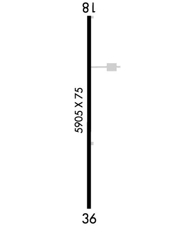
| Lat: N 3959.1 Long: W 09048.2 Elev: 734 Var: -01 Longest Runway: 5905 | ||
| AWOS: 118.32 CTAF: 122.8 | ||
| ||||||||||||||||||||||||||||||||||||||||||||
| ||||||||||||||||||||||||||||||||||||||||||||
| ||||||||||||||||||||||||||||||||||||||||||||
| Rwy | Rwy | |||||||
| 5905x75 | 5905' | 5905x75 | 5905' | |||||
| Runway ID | Single Wheel | Double Wheel | Double Tandem Wheel | Dual Double Wheel |
| 18/36 | N/A | N/A | N/A | N/A |
| These numbers are Advisory and are not limits. The Airport Manager should have more accurate Weight Limits | ||||
 Airport Diagram might not be current. | |
| Facility Name: | MOUNT STERLING MUNI |
| City Name: | MOUNT STERLING |
| County: | BROWN |
| State abbrev: | IL |
| State Name: | ILLINOIS |
| Ownership: | PUBLICLY OWNED |
| Use: | OPEN TO THE PUBLIC |
| Owner's Name: | CITY OF MOUNT STERLING |
| Address: | 145 W. MAIN |
| MOUNT STERLING, IL 62353 | |
| Owner's Phone: | 217-773-4411; EXT 12644 |
| Manager's Name: | PAUL WALKER |
| Address: | 145 W. MAIN |
| MOUNT STERLING, IL 62353 | |
| Phone: | 217-779-7329 |
| FAA Region: | GREAT LAKES |
| FAA Field Office: | CHI |
| Date | Sunrise | Sunset |
|---|---|---|
| 06/08/26 Monday | 5:34 | 20:30 |
| 06/09/26 Tuesday | 5:34 | 20:31 |
| 06/10/26 Wednesday | 5:34 | 20:31 |
| 06/11/26 Thursday | 5:34 | 20:32 |
| 06/12/26 Friday | 5:34 | 20:32 |
| 06/13/26 Saturday | 5:34 | 20:33 |
| 06/14/26 Sunday | 5:34 | 20:33 |
| 06/15/26 Monday | 5:34 | 20:34 |
| 06/16/26 Tuesday | 5:34 | 20:34 |
| 06/17/26 Wednesday | 5:34 | 20:34 |
| 06/18/26 Thursday | 5:34 | 20:35 |
| 06/19/26 Friday | 5:34 | 20:35 |
| 06/20/26 Saturday | 5:34 | 20:35 |
| 06/21/26 Sunday | 5:34 | 20:35 |
| Airport Attendance Schedule | IRREGULAR |
| Airport Status | OPERATIONAL (This Status can change at any time - please check NOTAMS) |
| Airport Lighting Schedule | ACTVT MIRL RWY 18/36; PAPI RWY 18 & 36 - CTAF. |
| Airport Storage Available | Tie Downs |
| Extra Services Available | Crop Dusting |
| Wind Indicator | YES - (lighted) |
| Control Tower | NO |
| CTAF Frequency | 122.800 |
| Unicom Frequency | 122.800 |
| Rotating Beacon Color | WG |
| Segmented Circle | NO |
| Landing Fee |
| Airport Inspected | STATE - performed by STATE AERONAUTICAL PERSONNEL |
| Inspection Date | 06/13/2023 |
| Type of Fuel Available | Grade 100LL, JET A (freeze point -40C); -10FUEL NOW AVBL TO PUBLIC - SELF SERVICE. |
| Airframe Repair Service | None |
| Power Plant Repair Service | None |
| Latitude | N3959.1 |
| Longitude | W09048.2 (ESTIMATED) |
| Arpt Elevation | 733ft (SURVEYED) |
| Magnetic Variation | 01E |
| 2 miles W | of MOUNT STERLING |
| Traffic Pattern Altitude | |
| Sectional Chart | ST LOUIS |
| Operations (Reported) | Yearly | Avg. Daily |
|---|---|---|
| General Aviation Transient | 0 | 0 |
| General Aviation Local | 0 | 0 |
| Air Taxi | 0 | 0 |
| Commerical | 0 | 0 |
| Commuter | 0 | 0 |
| Military | 0 | 0 |
| Aircraft based on Field | |
|---|---|
| General Aviation Singles | 0 |
| General Aviation Multi | 0 |
| Jet Aircraft | 0 |
| General Aviation Helicopters | 0 |
| Military Aircraft | 0 |
| Gliders | 0 |
| Ultralights | 0 |
| FSS on field | NO |
| FSS tie-in | SAINT LOUIS |
| FSS Phone | 1-800-WX-BRIEF |
| Who issues Notams | STL |
| Notam D service at airport | YES |
| ARTCC Name | KANSAS CITY |
| Airport Certification | |
| Aircraft Rescue & Firefighting Index | None |
| Airport of Entry | No |
| Custom Landing Rights | No |
| Joint Civil/Military | No |
| Military Landing rights | No |
| NATIONAL PLAN OF INTEGRATED AIRPORT SYSTEMS (NPIAS) |
| FOR CD CTC KANSAS CITY ARTCC AT 913-254-8508. |
Airport Communications & Frequencies:
| |||||||||
| Runway: 18 | Runway: 36 | ||
| Mag heading: | 180° | Mag heading: | 0° |
| Rwy Slope: | -.31% Down | Rwy Slope: | .31% Up |
| Approach: | Approach: | ||
| Pattern: | Left Traffic | Pattern: | Left Traffic |
| Markings: | NONPRECISION INSTRUMENT | Markings: | NONPRECISION INSTRUMENT |
| Marking Condition: | FAIR | Marking Condition: | FAIR |
| Arresting Dev: | Arresting Dev: | ||
| Lat & Long: | N3959.6 W09048.2 | Lat. & Long.: | N3958.6 W09048.3 |
| Elev: | 733.7 ft. MSL | Elev: | 715.2 ft. MSL |
| TCH: | 43 ft. AGL | TCH: | 42 ft. AGL |
| Visual Glide Path: | 3.00 degrees | Visual Glide Path: | 3.00 degrees |
| Displaced Threshold: | No | Displaced Threshold: | No |
| Touchdown Zone: | YES | Touchdown Zone: | YES |
| Touchdown Elev.: | 733.7 feet | Touchdown Elev.: | 725.0 feet |
| Visual Glide Slope: | 4-Light PAPI on LEFT side of Runway | Visual Glide Slope: | 4-Light PAPI on LEFT side of Runway |
| RVR Equipment: | RVR Equipment: | ||
| RVV Equipment: | NO | RVV Equipment: | NO |
| Approach Lights: | Approach Lights: | ||
| REIL: | NO | REIL: | NO |
| Centerline Lights: | NO | Centerline Lights: | NO |
| Touchdown lights: | NO | Touchdown lights: | NO |
| Runway Category: | Runway with a Non-precision Approach having visibility minimums greater than 3/4 mile | Runway Category: | Runway with a Non-precision Approach having visibility minimums greater than 3/4 mile |
| Declared Distances: | Declared Distances: | ||
| Obstructions: | POLE | Obstructions: | |
| Marked: | MARKED | Marked: | |
| Clearance slope: | 31:1 | Clearance slope: | 34:1 |
| Obstruction height: | 44 feet AGL | Obstruction height: | |
| Dist. from runway: | 1577 feet | Dist. from runway: | |
| Centerline offset: | 255 left of centerline | Centerline offset: | |
| Comments: | Comments: |
Thanks for using FltPlan.com
all rights reserved © 1999-2026 by Flight Plan LLC
