| RANDOLPH COUNTY WINCHESTER IN |
| |
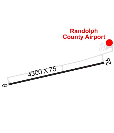
| Lat: N 4010.1 Long: W 08455.8 Elev: 1123 Var: +05 Longest Runway: 4300 | ||
| CTAF: 123.0 | ||
| |||||||||||||||||||||||||||||||||||||||||||||||||||||||||||||
| |||||||||||||||||||||||||||||||||||||||||||||||||||||||||||||
| Rwy | Rwy | |||||||
| 4300x75 | 4300' | 4300x75 | 4300' | |||||
| Runway ID | Single Wheel | Double Wheel | Double Tandem Wheel | Dual Double Wheel |
| 08/26 | 64,000 | 90,000 | 176,000 | N/A |
| These numbers are Advisory and are not limits. The Airport Manager should have more accurate Weight Limits | ||||
 Airport Diagram might not be current. | |
| Facility Name: | RANDOLPH COUNTY |
| City Name: | WINCHESTER |
| County: | RANDOLPH |
| State abbrev: | IN |
| State Name: | INDIANA |
| Ownership: | PUBLICLY OWNED |
| Use: | OPEN TO THE PUBLIC |
| Owner's Name: | RANDOLPH CO BOAC |
| Address: | 2937 E STATE RD32 |
| WINCHESTER, IN 47394 | |
| Owner's Phone: | 765-584-3611 |
| Manager's Name: | ERIC LIVINGSTON |
| Address: | 2937 E STATE RD 32 |
| WINCHESTER, IN 47394 | |
| Phone: | 765-584-3611 |
| FAA Region: | GREAT LAKES |
| FAA Field Office: | CHI |
| Date | Sunrise | Sunset |
|---|---|---|
| 09/24/21 Friday | 7:29 | 19:34 |
| 09/25/21 Saturday | 7:30 | 19:32 |
| 09/26/21 Sunday | 7:31 | 19:31 |
| 09/27/21 Monday | 7:32 | 19:29 |
| 09/28/21 Tuesday | 7:33 | 19:27 |
| 09/29/21 Wednesday | 7:34 | 19:26 |
| 09/30/21 Thursday | 7:35 | 19:24 |
| 10/01/21 Friday | 7:36 | 19:22 |
| 10/02/21 Saturday | 7:37 | 19:21 |
| 10/03/21 Sunday | 7:38 | 19:19 |
| 10/04/21 Monday | 7:39 | 19:17 |
| 10/05/21 Tuesday | 7:40 | 19:16 |
| 10/06/21 Wednesday | 7:41 | 19:14 |
| 10/07/21 Thursday | 7:42 | 19:13 |
| Airport Attendance Schedule | MON-SAT 0800-1700, SUN 1300-1700; ARPT CLSD THANKSGIVING & CHRISTMAS DAY. |
| Airport Status | OPERATIONAL (This Status can change at any time - please check NOTAMS) |
| Airport Lighting Schedule | ACTVT MIRL RY 08/26; REIL RY 08/26; PAPI RY 08/26 - CTAF. |
| Airport Storage Available | Tie Downs, Hanger |
| Extra Services Available | Flight Instruction, Aircraft Rental |
| Wind Indicator | YES - (lighted) |
| Control Tower | NO |
| CTAF Frequency | 123.000 |
| Unicom Frequency | 123.000 |
| Rotating Beacon Color | CLEAR-GREEN (Light Land Airport) |
| Segmented Circle | NO |
| Landing Fee | NO |
| Airport Inspected | STATE - performed by STATE AERONAUTICAL PERSONNEL |
| Inspection Date | 08/05/2019 |
| Type of Fuel Available | Grade 100LL, JET A (freeze point -40C) |
| Airframe Repair Service | MINOR |
| Power Plant Repair Service | MINOR |
| Latitude | N4010.1 |
| Longitude | W08455.8 (ESTIMATED) |
| Arpt Elevation | 1122ft (SURVEYED) |
| Magnetic Variation | 05W |
| 3 miles E | of WINCHESTER |
| Traffic Pattern Altitude | 800 |
| Sectional Chart | DETROIT |
| Operations (Reported) | Yearly | Avg. Daily |
|---|---|---|
| General Aviation Transient | 1039 | 3 |
| General Aviation Local | 977 | 3 |
| Air Taxi | 62 | 0 |
| Commerical | 0 | 0 |
| Commuter | 0 | 0 |
| Military | 0 | 0 |
| Aircraft based on Field | |
|---|---|
| General Aviation Singles | 12 |
| General Aviation Multi | 0 |
| Jet Aircraft | 0 |
| General Aviation Helicopters | 0 |
| Military Aircraft | 0 |
| Gliders | 0 |
| Ultralights | 0 |
| FSS on field | NO |
| FSS tie-in | TERRE HAUTE |
| FSS Phone | 1-800-WX-BRIEF |
| Who issues Notams | HUF |
| Notam D service at airport | YES |
| ARTCC Name | INDIANAPOLIS |
| Airport Certification | |
| Aircraft Rescue & Firefighting Index | None |
| Airport of Entry | No |
| Custom Landing Rights | No |
| Joint Civil/Military | No |
| Military Landing rights | No |
| NATIONAL PLAN OF INTEGRATED AIRPORT SYSTEMS (NPIAS) |
| COLUMBUS APCH CD (614) 338-8537. |
Airport Communications & Frequencies:
| ||||||||||||||||||
| Runway: 08 | Runway: 26 | ||
| Mag heading: | 82° | Mag heading: | 262° |
| Rwy Slope: | .16% Up | Rwy Slope: | -.16% Down |
| Approach: | Approach: | ||
| Pattern: | Left Traffic | Pattern: | Left Traffic |
| Markings: | NONPRECISION INSTRUMENT | Markings: | NONPRECISION INSTRUMENT |
| Marking Condition: | GOOD | Marking Condition: | GOOD |
| Arresting Dev: | Arresting Dev: | ||
| Lat & Long: | N4010.0 W08456.2 | Lat. & Long.: | N4010.1 W08455.3 |
| Elev: | 1115.9 ft. MSL | Elev: | 1122.8 ft. MSL |
| TCH: | 25 ft. AGL | TCH: | 25 ft. AGL |
| Visual Glide Path: | 3.00 degrees | Visual Glide Path: | 3.00 degrees |
| Displaced Threshold: | No | Displaced Threshold: | No |
| Touchdown Zone: | YES | Touchdown Zone: | YES |
| Touchdown Elev.: | 1120.8 feet | Touchdown Elev.: | 1122.8 feet |
| Visual Glide Slope: | 2-Light PAPI on LEFT side of Runway | Visual Glide Slope: | 2-Light PAPI on LEFT side of Runway |
| RVR Equipment: | RVR Equipment: | ||
| RVV Equipment: | NO | RVV Equipment: | NO |
| Approach Lights: | Approach Lights: | ||
| REIL: | YES | REIL: | YES |
| Centerline Lights: | NO | Centerline Lights: | NO |
| Touchdown lights: | NO | Touchdown lights: | NO |
| Runway Category: | Runway with a Non-precision Approach | Runway Category: | Runway with a Non-precision Approach |
| Declared Distances: | Declared Distances: | ||
| Obstructions: | CROPS | Obstructions: | ROAD |
| Marked: | NOT Marked/Lighted | Marked: | NOT Marked/Lighted |
| Clearance slope: | 34:1 | Clearance slope: | 34:1 |
| Obstruction height: | 17 feet AGL | Obstruction height: | 13 feet AGL |
| Dist. from runway: | 780 feet | Dist. from runway: | 650 feet |
| Centerline offset: | 210 right of centerline | Centerline offset: | |
| Comments: | Comments: |
Thanks for using FltPlan.com
all rights reserved © 1999-2021 by Flight Plan LLC