
| CITY OF TULIA/SWISHER COUNTY M TULIA TX |
| |
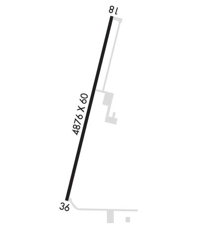
| Lat: N 3434.0 Long: W 10146.9 Elev: 3503 Var: -09 Longest Runway: 4876 | ||
| CTAF: 122.7 | ||
| ||||||
|
| Rwy | Rwy | |||||||
| 4876x60 | 4876' | 4876x60 | 4876' | |||||
| Runway ID | Single Wheel | Double Wheel | Double Tandem Wheel | Dual Double Wheel |
| 01/19 | 12,500 | N/A | N/A | N/A |
| These numbers are Advisory and are not limits. The Airport Manager should have more accurate Weight Limits | ||||
| FltPlan does not have IFR approach charts available for KI06. |
 Airport Diagram might not be current. | |
| Facility Name: | CITY OF TULIA/SWISHER COUNTY MUNI |
| City Name: | TULIA |
| County: | SWISHER |
| State abbrev: | TX |
| State Name: | TEXAS |
| Ownership: | PUBLICLY OWNED |
| Use: | OPEN TO THE PUBLIC |
| Owner's Name: | CITY OF TULIA & SWISHER COUNTY |
| Address: | CITY HALL, 127 S.W. 2ND |
| TULIA, TX 79088 | |
| Owner's Phone: | 806-995-3547 |
| Manager's Name: | MICHAEL CLAWSON, CO. JUDGE; ADD'L CONTACTS: B.J. POTTS, CITY MGR, 806-995-3547; DOUG BARNES, A&P, 806-786-2773. |
| Address: | SWISHER CO. COURTHOUSE, 119 S. MAXWELL |
| TULIA, TX 79088 | |
| Phone: | 806-786-2773 |
| FAA Region: | SOUTHWEST |
| FAA Field Office: | TEX |
| Date | Sunrise | Sunset |
|---|---|---|
| 06/07/26 Sunday | 6:34 | 20:58 |
| 06/08/26 Monday | 6:34 | 20:58 |
| 06/09/26 Tuesday | 6:34 | 20:59 |
| 06/10/26 Wednesday | 6:34 | 20:59 |
| 06/11/26 Thursday | 6:34 | 21:00 |
| 06/12/26 Friday | 6:34 | 21:00 |
| 06/13/26 Saturday | 6:34 | 21:01 |
| 06/14/26 Sunday | 6:34 | 21:01 |
| 06/15/26 Monday | 6:34 | 21:01 |
| 06/16/26 Tuesday | 6:34 | 21:02 |
| 06/17/26 Wednesday | 6:34 | 21:02 |
| 06/18/26 Thursday | 6:34 | 21:02 |
| 06/19/26 Friday | 6:34 | 21:03 |
| 06/20/26 Saturday | 6:34 | 21:03 |
| Airport Attendance Schedule | 7 Days A Week INTMNT |
| Airport Status | OPERATIONAL (This Status can change at any time - please check NOTAMS) |
| Airport Lighting Schedule | MIRL RWY 01/19 PRESET LOW INTST; TO INCR INTST ACTVT - 122.8. |
| Airport Storage Available | Tie Downs |
| Extra Services Available | NONE |
| Wind Indicator | YES - (lighted) |
| Control Tower | NO |
| CTAF Frequency | 122.700 |
| Unicom Frequency | 122.700 |
| Rotating Beacon Color | WG |
| Segmented Circle | YES |
| Landing Fee | NO |
| Airport Inspected | STATE - performed by PRIVATE CONTRACT PERSONNEL |
| Inspection Date | 04/16/2024 |
| Type of Fuel Available | Grade 100LL; -10FUEL SELF SERVE. FOR ASSISTANCE CALL 806-995-3504 DURING REG. BUS. HRS. |
| Airframe Repair Service | None |
| Power Plant Repair Service | None |
| Latitude | N3434.0 |
| Longitude | W10146.9 (ESTIMATED) |
| Arpt Elevation | 3503ft (SURVEYED) |
| Magnetic Variation | 09E |
| 2 miles NW | of TULIA |
| Traffic Pattern Altitude | |
| Sectional Chart | DALLAS-FT WORTH |
| Operations (Reported) | Yearly | Avg. Daily |
|---|---|---|
| General Aviation Transient | 0 | 0 |
| General Aviation Local | 0 | 0 |
| Air Taxi | 0 | 0 |
| Commerical | 0 | 0 |
| Commuter | 0 | 0 |
| Military | 0 | 0 |
| Aircraft based on Field | |
|---|---|
| General Aviation Singles | 0 |
| General Aviation Multi | 0 |
| Jet Aircraft | 0 |
| General Aviation Helicopters | 0 |
| Military Aircraft | 0 |
| Gliders | 0 |
| Ultralights | 0 |
| FSS on field | NO |
| FSS tie-in | FORT WORTH |
| FSS Phone | 1-800-WX-BRIEF |
| Who issues Notams | FTW |
| Notam D service at airport | YES |
| ARTCC Name | FORT WORTH |
| Airport Certification | |
| Aircraft Rescue & Firefighting Index | None |
| Airport of Entry | No |
| Custom Landing Rights | No |
| Joint Civil/Military | No |
| Military Landing rights | YES |
| NATIONAL PLAN OF INTEGRATED AIRPORT SYSTEMS (NPIAS) |
| GRANT AGREEMENTS UNDER FAAP/ADAP/AIP |
| ASSURANCES PURSUANT TO TITLE VI, CIVIL RIGHTS ACT OF 1964 |
| THIS AIRPORT HAS BEEN SURVEYED BY THE NATIONAL GEODETIC SURVEY. |
| LIVESTOCK INVOF ARPT. |
| FOR CD CTC FORT WORTH ARTCC AT 817-858-7584. |
| Runway: 01 | Runway: 19 | ||
| Mag heading: | N/A | Mag heading: | N/A |
| Rwy Slope: | .31% Up | Rwy Slope: | -.31% Down |
| Approach: | Approach: | ||
| Pattern: | Left Traffic | Pattern: | Left Traffic |
| Markings: | NONPRECISION INSTRUMENT | Markings: | NONPRECISION INSTRUMENT |
| Marking Condition: | GOOD | Marking Condition: | GOOD |
| Arresting Dev: | Arresting Dev: | ||
| Lat & Long: | N3433.6 W10147.0 | Lat. & Long.: | N3434.4 W10146.8 |
| Elev: | 3487.7 ft. MSL | Elev: | 3502.9 ft. MSL |
| TCH: | TCH: | ||
| Visual Glide Path: | Visual Glide Path: | ||
| Displaced Threshold: | No | Displaced Threshold: | No |
| Touchdown Zone: | YES | Touchdown Zone: | YES |
| Touchdown Elev.: | 3497.0 feet | Touchdown Elev.: | 3503.0 feet |
| Visual Glide Slope: | Visual Glide Slope: | ||
| RVR Equipment: | RVR Equipment: | ||
| RVV Equipment: | NO | RVV Equipment: | NO |
| Approach Lights: | Approach Lights: | ||
| REIL: | NO | REIL: | NO |
| Centerline Lights: | NO | Centerline Lights: | NO |
| Touchdown lights: | NO | Touchdown lights: | NO |
| Runway Category: | Runway with a Visual Approach | Runway Category: | Runway with a Visual Approach |
| Declared Distances: | Declared Distances: | ||
| Obstructions: | ROAD | Obstructions: | |
| Marked: | NOT Marked/Lighted | Marked: | |
| Clearance slope: | 23:1 | Clearance slope: | 20:1 |
| Obstruction height: | 15 feet AGL | Obstruction height: | |
| Dist. from runway: | 550 feet | Dist. from runway: | |
| Centerline offset: | 160B | Centerline offset: | |
| Comments: | Comments: |
Thanks for using FltPlan.com
all rights reserved © 1999-2026 by Flight Plan LLC
