
| MERCER COUNTY RGNL HAZEN ND |
| |
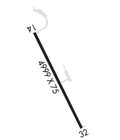
| Lat: N 4717.4 Long: W 10134.9 Elev: 1814 Var: -09 Longest Runway: 4999 | ||
| CTAF: 122.8 | ||
| ||||||||||||||||||||||||||||||||
| ||||||||||||||||||||||||||||||||
| ||||||||||||||||||||||||||||||||
| ||||||||||||||||||||||||||||||||
| Rwy | Rwy | |||||||
| 4999x75 | 4999' | 4999x75 | 4999' | |||||
| Runway ID | Single Wheel | Double Wheel | Double Tandem Wheel | Dual Double Wheel |
| 14/32 | 17,000 | N/A | N/A | N/A |
| These numbers are Advisory and are not limits. The Airport Manager should have more accurate Weight Limits | ||||
 Airport Diagram might not be current. | |
| Facility Name: | MERCER COUNTY RGNL |
| City Name: | HAZEN |
| County: | MERCER |
| State abbrev: | ND |
| State Name: | NORTH DAKOTA |
| Ownership: | PUBLICLY OWNED |
| Use: | OPEN TO THE PUBLIC |
| Owner's Name: | MERCER CO REG ARPT AUTH |
| Address: | PO BOX 507; APT. MANAGER - STEVE FROVARP |
| HAZEN, ND 58545 | |
| Owner's Phone: | (701) 880-0042; CHAIR OF APT. AUTHORITY - WAYNE ENTZE. |
| Manager's Name: | STEVE FROVARP; APT. MANAGER AND CLERK OF ARPT AUTH. |
| Address: | PO BOX 507 |
| HAZEN, ND 58545 | |
| Phone: | (701) 748-6501 |
| FAA Region: | GREAT LAKES |
| FAA Field Office: | DMA |
| Date | Sunrise | Sunset |
|---|---|---|
| 09/24/21 Friday | 7:35 | 19:40 |
| 09/25/21 Saturday | 7:37 | 19:38 |
| 09/26/21 Sunday | 7:38 | 19:36 |
| 09/27/21 Monday | 7:40 | 19:34 |
| 09/28/21 Tuesday | 7:41 | 19:32 |
| 09/29/21 Wednesday | 7:42 | 19:30 |
| 09/30/21 Thursday | 7:44 | 19:28 |
| 10/01/21 Friday | 7:45 | 19:26 |
| 10/02/21 Saturday | 7:46 | 19:24 |
| 10/03/21 Sunday | 7:48 | 19:22 |
| 10/04/21 Monday | 7:49 | 19:20 |
| 10/05/21 Tuesday | 7:50 | 19:18 |
| 10/06/21 Wednesday | 7:52 | 19:16 |
| 10/07/21 Thursday | 7:53 | 19:14 |
| Airport Attendance Schedule | UNATTENDED |
| Airport Status | OPERATIONAL (This Status can change at any time - please check NOTAMS) |
| Airport Lighting Schedule | ACTVT MIRL RY 14/32, REIL RY 32 AND PAPI RYS 14 & 32 - CTAF. |
| Airport Storage Available | Tie Downs, Hanger |
| Extra Services Available | Crop Dusting |
| Wind Indicator | YES - (lighted) |
| Control Tower | NO |
| CTAF Frequency | 122.800 |
| Unicom Frequency | 122.800 |
| Rotating Beacon Color | CLEAR-GREEN (Light Land Airport) |
| Segmented Circle | YES |
| Landing Fee | NO |
| Airport Inspected | STATE - performed by STATE AERONAUTICAL PERSONNEL |
| Inspection Date | 08/10/2017 |
| Type of Fuel Available | Grade 100LL, JET A (freeze point -40C); -A SINGLE POINT JET FUELING AVBL.; -10SELF SVC FUEL AVBL 24HRS WITH CREDIT CARD. |
| Airframe Repair Service | MINOR |
| Power Plant Repair Service | MINOR |
| Latitude | N4717.4 |
| Longitude | W10134.9 (ESTIMATED) |
| Arpt Elevation | 1814ft (SURVEYED) |
| Magnetic Variation | 09E |
| 2 miles E | of HAZEN |
| Traffic Pattern Altitude | |
| Sectional Chart | BILLINGS |
| Operations (Reported) | Yearly | Avg. Daily |
|---|---|---|
| General Aviation Transient | 500 | 1 |
| General Aviation Local | 800 | 2 |
| Air Taxi | 200 | 1 |
| Commerical | 0 | 0 |
| Commuter | 0 | 0 |
| Military | 30 | 0 |
| Aircraft based on Field | |
|---|---|
| General Aviation Singles | 16 |
| General Aviation Multi | 0 |
| Jet Aircraft | 0 |
| General Aviation Helicopters | 0 |
| Military Aircraft | 0 |
| Gliders | 0 |
| Ultralights | 0 |
| FSS on field | NO |
| FSS tie-in | GRAND FORKS |
| FSS Phone | 1-800-WX-BRIEF |
| Who issues Notams | GFK |
| Notam D service at airport | YES |
| ARTCC Name | MINNEAPOLIS |
| Airport Certification | |
| Aircraft Rescue & Firefighting Index | None |
| Airport of Entry | No |
| Custom Landing Rights | No |
| Joint Civil/Military | No |
| Military Landing rights | No |
| NATIONAL PLAN OF INTEGRATED AIRPORT SYSTEMS (NPIAS) |
| CFM SNOW REMOVAL OCT-APR; CALL 701-880-0042. |
| TRANSPORTATION SVC CALL 701-880-0042. |
| 654 FT LIGHTED TOWER 3.8 NM FM THLD RY 14. |
| ACFT PAINT & UPHOLSTRY SHOP AVBL CALL 701-748-5592/6714. |
| COLD TEMPERTURE RESTRICTED AIRPORT, ALTITUDE CORRECTION REQUIRED AT OR BELOW -41 DEG C/ -42 DEG F. |
| BIRDS & DEER ON & INVOF ARPT. |
| FOR CD IF UNA TO CTC ON FSS FREQ, CTC MINNEAPOLIS ARTCC AT 651-463-5588. |
| RWY 14/3 2 APRON HAS 2 CONC 20000 LB SW TIEDOWN SPACES. |
| RWY 14/32 TWY & APRON MARKED WITH REFLECTORS. |
Airport Communications & Frequencies:
| |||||||||
| Runway: 14 | Runway: 32 | ||
| Mag heading: | 144° | Mag heading: | 324° |
| Rwy Slope: | .56% Up | Rwy Slope: | -.56% Down |
| Approach: | Approach: | ||
| Pattern: | Left Traffic | Pattern: | Left Traffic |
| Markings: | NONPRECISION INSTRUMENT | Markings: | NONPRECISION INSTRUMENT |
| Marking Condition: | GOOD | Marking Condition: | GOOD |
| Arresting Dev: | Arresting Dev: | ||
| Lat & Long: | N4717.8 W10135.1 | Lat. & Long.: | N4717.0 W10134.6 |
| Elev: | 1786.4 ft. MSL | Elev: | 1814.3 ft. MSL |
| TCH: | 27 ft. AGL | TCH: | 29 ft. AGL |
| Visual Glide Path: | 3.00 degrees | Visual Glide Path: | 3.00 degrees |
| Displaced Threshold: | No | Displaced Threshold: | No |
| Touchdown Zone: | YES | Touchdown Zone: | YES |
| Touchdown Elev.: | 1786.5 feet | Touchdown Elev.: | 1814.3 feet |
| Visual Glide Slope: | 2-Light PAPI on LEFT side of Runway | Visual Glide Slope: | 2-Light PAPI on LEFT side of Runway |
| RVR Equipment: | RVR Equipment: | ||
| RVV Equipment: | NO | RVV Equipment: | NO |
| Approach Lights: | Approach Lights: | ||
| REIL: | NO | REIL: | YES |
| Centerline Lights: | NO | Centerline Lights: | NO |
| Touchdown lights: | NO | Touchdown lights: | NO |
| Runway Category: | Runway with a Non-precision Approach having visibility minimums greater than 3/4 mile | Runway Category: | Runway with a Non-precision Approach having visibility minimums greater than 3/4 mile |
| Declared Distances: | Declared Distances: |
Thanks for using FltPlan.com
all rights reserved © 1999-2021 by Flight Plan LLC
