
| SAWYER COUNTY HAYWARD WI |
| |
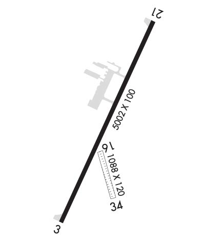
| Lat: N 4601.5 Long: W 09126.7 Elev: 1216 Var: -00 Longest Runway: 5003 | ||
| AWOS: 113.4 CTAF: 122.8 | ||
| ||||||||||||||||||||||||||||||||||||||||||||
| ||||||||||||||||||||||||||||||||||||||||||||
| ||||||||||||||||||||||||||||||||||||||||||||
| Rwy | Rwy | |||||||
| 5003x100 | 5003' | 5003x100 | 5003' | 108.50 - 204° | ||||
| 1088x120 | 1088' | 1088x120 | 1088' | |||||
| Runway ID | Single Wheel | Double Wheel | Double Tandem Wheel | Dual Double Wheel |
| 03/21 | 74,000 | 106,000 | 173,000 | N/A |
| 16/34 | N/A | N/A | N/A | N/A |
| These numbers are Advisory and are not limits. The Airport Manager should have more accurate Weight Limits | ||||
 Airport Diagram might not be current. | |
| Facility Name: | SAWYER COUNTY |
| City Name: | HAYWARD |
| County: | SAWYER |
| State abbrev: | WI |
| State Name: | WISCONSIN |
| Ownership: | PUBLICLY OWNED |
| Use: | OPEN TO THE PUBLIC |
| Owner's Name: | SAWYER COUNTY |
| Address: | COURTHOUSE |
| HAYWARD, WI 54843 | |
| Owner's Phone: | 715-634-4866 |
| Manager's Name: | DEREK LESLIE |
| Address: | 10930 N ARPT RD |
| HAYWARD, WI 54843 | |
| Phone: | 715-634-4624 |
| FAA Region: | GREAT LAKES |
| FAA Field Office: | CHI |
| Date | Sunrise | Sunset |
|---|---|---|
| 06/08/26 Monday | 5:15 | 20:54 |
| 06/09/26 Tuesday | 5:15 | 20:55 |
| 06/10/26 Wednesday | 5:15 | 20:56 |
| 06/11/26 Thursday | 5:15 | 20:56 |
| 06/12/26 Friday | 5:14 | 20:57 |
| 06/13/26 Saturday | 5:14 | 20:57 |
| 06/14/26 Sunday | 5:14 | 20:58 |
| 06/15/26 Monday | 5:14 | 20:58 |
| 06/16/26 Tuesday | 5:14 | 20:59 |
| 06/17/26 Wednesday | 5:14 | 20:59 |
| 06/18/26 Thursday | 5:14 | 20:59 |
| 06/19/26 Friday | 5:14 | 21:00 |
| 06/20/26 Saturday | 5:15 | 21:00 |
| 06/21/26 Sunday | 5:15 | 21:00 |
| Airport Attendance Schedule | MAY-OCT 7 Days A Week 0800-1800, NOV - APR 7 Days A Week 0800 -1700 |
| Airport Status | OPERATIONAL (This Status can change at any time - please check NOTAMS) |
| Airport Lighting Schedule | ACTVT MALSR RWY 21; REIL RWY 03; PAPI RWY 03 & 21; HIRL RWY 03/21 - CTAF. SS-SR HIRL RWY 03/21 PRESET TO LOW; TO INCR INTST - CTAF. |
| Airport Storage Available | Tie Downs, Hanger |
| Extra Services Available | Flight Instruction, Aircraft Rental |
| Wind Indicator | YES - (lighted) |
| Control Tower | NO |
| CTAF Frequency | 122.800 |
| Unicom Frequency | 122.800 |
| Rotating Beacon Color | WG |
| Segmented Circle | NO |
| Landing Fee | NO |
| Airport Inspected | STATE - performed by STATE AERONAUTICAL PERSONNEL |
| Inspection Date | 06/20/2024 |
| Type of Fuel Available | Grade 100LL, JET A |
| Airframe Repair Service | NONE |
| Power Plant Repair Service | NONE |
| Latitude | N4601.5 |
| Longitude | W09126.7 (ESTIMATED) |
| Arpt Elevation | 1215ft (SURVEYED) |
| Magnetic Variation | 00E |
| 2 miles NE | of HAYWARD |
| Traffic Pattern Altitude | |
| Sectional Chart | GREEN BAY |
| Operations (Reported) | Yearly | Avg. Daily |
|---|---|---|
| General Aviation Transient | 0 | 0 |
| General Aviation Local | 0 | 0 |
| Air Taxi | 0 | 0 |
| Commerical | 0 | 0 |
| Commuter | 0 | 0 |
| Military | 0 | 0 |
| Aircraft based on Field | |
|---|---|
| General Aviation Singles | 0 |
| General Aviation Multi | 0 |
| Jet Aircraft | 0 |
| General Aviation Helicopters | 0 |
| Military Aircraft | 0 |
| Gliders | 0 |
| Ultralights | 0 |
| FSS on field | NO |
| FSS tie-in | GREEN BAY |
| FSS Phone | 1-800-WX-BRIEF |
| Who issues Notams | HYR |
| Notam D service at airport | YES |
| ARTCC Name | MINNEAPOLIS |
| Airport Certification | |
| Aircraft Rescue & Firefighting Index | None |
| Airport of Entry | No |
| Custom Landing Rights | No |
| Joint Civil/Military | No |
| Military Landing rights | YES |
| NATIONAL PLAN OF INTEGRATED AIRPORT SYSTEMS (NPIAS) |
| GRANT AGREEMENTS UNDER FAAP/ADAP/AIP |
| ASSURANCES PURSUANT TO TITLE VI, CIVIL RIGHTS ACT OF 1964 |
| BIRDS ON & INVOF ARPT. |
| ARPT COND UNMON 1700-0800. |
| FOR CD IF UNA VIA FREQ CTC MINNEAPOLIS ARTCC AT 651-463-5588. |
| RWY 16/3 4 CLSD DEC 1 - APR 15. |
| RWY 03/2 1 PCR VALUE: 290/F/C/X/T |
Airport Communications & Frequencies:
| |||||||||
| Runway: 03 | Runway: 21 | ||
| Mag heading: | 25° | Mag heading: | 205° |
| Rwy Slope: | .15% Up | Rwy Slope: | -.15% Down |
| Approach: | Approach: | ILS/DME | |
| Pattern: | Left Traffic | Pattern: | Left Traffic |
| Markings: | NONPRECISION INSTRUMENT | Markings: | PRECISION INSTRUMENT |
| Marking Condition: | GOOD | Marking Condition: | GOOD |
| Arresting Dev: | Arresting Dev: | ||
| Lat & Long: | N4601.2 W09126.9 | Lat. & Long.: | N4601.9 W09126.4 |
| Elev: | 1208.4 ft. MSL | Elev: | 1215.8 ft. MSL |
| TCH: | 34 ft. AGL | TCH: | 45 ft. AGL |
| Visual Glide Path: | 3.00 degrees | Visual Glide Path: | 3.00 degrees |
| Displaced Threshold: | No | Displaced Threshold: | No |
| Touchdown Zone: | YES | Touchdown Zone: | YES |
| Touchdown Elev.: | 1213.7 feet | Touchdown Elev.: | 1215.9 feet |
| Visual Glide Slope: | 4-Light PAPI on LEFT side of Runway | Visual Glide Slope: | 4-Light PAPI on RIGHT side of Runway |
| RVR Equipment: | RVR Equipment: | ||
| RVV Equipment: | NO | RVV Equipment: | NO |
| Approach Lights: | Approach Lights: | MALSR - 1,400 foot medium intensity approach lighting system with runway alignment indicator lights | |
| REIL: | YES | REIL: | NO |
| Centerline Lights: | NO | Centerline Lights: | NO |
| Touchdown lights: | NO | Touchdown lights: | NO |
| Runway Category: | Runway with a Non-precision Approach having visibility minimums greater than 3/4 mile | Runway Category: | Precision Instrument Runway |
| Declared Distances: | Declared Distances: | ||
| Obstructions: | FENCE | Obstructions: | TREES |
| Marked: | LIGHTED | Marked: | NOT Marked/Lighted |
| Clearance slope: | 8:1 | Clearance slope: | 34:1 |
| Obstruction height: | 7 feet AGL | Obstruction height: | 88 feet AGL |
| Dist. from runway: | 260 feet | Dist. from runway: | 3200 feet |
| Centerline offset: | 500 left of centerline | Centerline offset: | 330 feet left of centerline |
| Comments: | Comments: |
| Runway: 16 | Runway: 34 | ||
| Mag heading: | 163° | Mag heading: | 343° |
| Rwy Slope: | -.11% Down | Rwy Slope: | .11% Up |
| Approach: | Approach: | ||
| Pattern: | Left Traffic | Pattern: | Left Traffic |
| Markings: | Markings: | ||
| Marking Condition: | YELLOW CONES. | Marking Condition: | YELLOW CONES. |
| Arresting Dev: | Arresting Dev: | ||
| Lat & Long: | N4601.4 W09126.7 | Lat. & Long.: | N4601.3 W09126.6 |
| Elev: | 1210.9 ft. MSL | Elev: | 1209.7 ft. MSL |
| TCH: | TCH: | ||
| Visual Glide Path: | Visual Glide Path: | ||
| Displaced Threshold: | No | Displaced Threshold: | No |
| Touchdown Zone: | YES | Touchdown Zone: | YES |
| Touchdown Elev.: | 1211.1 feet | Touchdown Elev.: | 1211.1 feet |
| Visual Glide Slope: | Visual Glide Slope: | ||
| RVR Equipment: | RVR Equipment: | ||
| RVV Equipment: | NO | RVV Equipment: | NO |
| Approach Lights: | Approach Lights: | ||
| REIL: | NO | REIL: | NO |
| Centerline Lights: | NO | Centerline Lights: | NO |
| Touchdown lights: | NO | Touchdown lights: | NO |
| Runway Category: | Runway with a Visual Approach | Runway Category: | Runway with a Visual Approach |
| Declared Distances: | Declared Distances: | ||
| Obstructions: | TREES | Obstructions: | TREES |
| Marked: | NOT Marked/Lighted | Marked: | NOT Marked/Lighted |
| Clearance slope: | 17:1 | Clearance slope: | 13:1 |
| Obstruction height: | 60 feet AGL | Obstruction height: | 53 feet AGL |
| Dist. from runway: | 1030 feet | Dist. from runway: | 700 feet |
| Centerline offset: | 200 right of centerline | Centerline offset: | 175 feet right of centerline |
| Comments: | Comments: |
Thanks for using FltPlan.com
all rights reserved © 1999-2026 by Flight Plan LLC
