
| SAN MARCOS MUNI AUSTIN TX |
| |
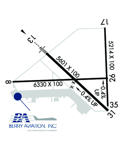
| Lat: N 2953.6 Long: W 09751.8 Elev: 595 Var: -07 Longest Runway: 6330 | ||
| Clr Del: 121.35 Dept. ATIS: 120.82 Arr. ATIS: 120.82 AWOS: 120.82 Ground: 120.12 Tower: 126.82 | ||
| |||||||||||||||||||||||||||||||||||||||||||||||||||||||||||||||||||||
| |||||||||||||||||||||||||||||||||||||||||||||||||||||||||||||||||||||
| |||||||||||||||||||||||||||||||||||||||||||||||||||||||||||||||||||||
| |||||||||||||||||||||||||||||||||||||||||||||||||||||||||||||||||||||
| |||||||||||||||||||||||||||||||||||||||||||||||||||||||||||||||||||||
| |||||||||||||||||||||||||||||||||||||||||||||||||||||||||||||||||||||
| Rwy | Rwy | |||||||
| 6330x100 | 6330' | 6330x100 | 6330' | |||||
| 5601x100 | 5601' | 108.70 - 125° | 5601x100 | 5601' | ||||
| 5214x100 | 5214' | 5214x100 | 5214' | |||||
| Runway ID | Single Wheel | Double Wheel | Double Tandem Wheel | Dual Double Wheel |
| 08/26 | 80,000 | N/A | N/A | N/A |
| 13/31 | 60,000 | N/A | N/A | N/A |
| 17/35 | 20,000 | N/A | N/A | N/A |
| These numbers are Advisory and are not limits. The Airport Manager should have more accurate Weight Limits | ||||
 Airport Diagram might not be current. | |
| Facility Name: | SAN MARCOS RGNL |
| City Name: | AUSTIN |
| County: | CALDWELL |
| State abbrev: | TX |
| State Name: | TEXAS |
| Ownership: | PUBLICLY OWNED |
| Use: | OPEN TO THE PUBLIC |
| Owner's Name: | CITY OF SAN MARCOS |
| Address: | 630 E. HOPKINS STREET |
| SAN MARCOS, TX 78666 | |
| Owner's Phone: | 512-216-6039 |
| Manager's Name: | TEXAS AVIATION PARTNERS; STEPHEN ALEXANDER PRIM CTC. |
| Address: | 4400 HWY 21, SUITE 200 |
| SAN MARCOS, TX 78666 | |
| Phone: | 512-216-6039; EMERG CTC: CITY OF SAN MARCOS POLICE DISPATCH - 512-753-2108 |
| FAA Region: | SOUTHWEST |
| FAA Field Office: | TEX |

| Date | Sunrise | Sunset |
|---|---|---|
| 09/24/21 Friday | 7:21 | 19:26 |
| 09/25/21 Saturday | 7:21 | 19:25 |
| 09/26/21 Sunday | 7:22 | 19:23 |
| 09/27/21 Monday | 7:22 | 19:22 |
| 09/28/21 Tuesday | 7:23 | 19:21 |
| 09/29/21 Wednesday | 7:24 | 19:20 |
| 09/30/21 Thursday | 7:24 | 19:18 |
| 10/01/21 Friday | 7:25 | 19:17 |
| 10/02/21 Saturday | 7:25 | 19:16 |
| 10/03/21 Sunday | 7:26 | 19:15 |
| 10/04/21 Monday | 7:26 | 19:14 |
| 10/05/21 Tuesday | 7:27 | 19:12 |
| 10/06/21 Wednesday | 7:28 | 19:11 |
| 10/07/21 Thursday | 7:28 | 19:10 |
| Airport Attendance Schedule | 7 Days A Week SR-SS |
| Airport Status | OPERATIONAL (This Status can change at any time - please check NOTAMS) |
| Airport Lighting Schedule | MIRL RWYS 08/26, 13/31 & 17/35 PRESET LOW INTST; TO INCR INTST AND ACTVT MALS RWY 13; PAPI RWYS 17, 13 & 31 - CTAF. |
| Airport Storage Available | Tie Downs, Hanger |
| Extra Services Available | Avionics, Charter, Flight Instruction, Aircraft Rental, Aircraft Sales |
| Wind Indicator | YES - (lighted) |
| Control Tower | YES |
| CTAF Frequency | 126.825 |
| Unicom Frequency | |
| Rotating Beacon Color | CLEAR-GREEN (Light Land Airport) |
| Segmented Circle | YES |
| Landing Fee | NO |
| Airport Inspected | STATE - performed by STATE AERONAUTICAL PERSONNEL |
| Inspection Date | 04/26/2017 |
| Type of Fuel Available | Grade 100LL, JET A (freeze point -40C); -10100LL SELF SERVICE WITH MAJOR CREDIT CARD. |
| Airframe Repair Service | MAJOR |
| Power Plant Repair Service | None |
| Latitude | N2953.6 |
| Longitude | W09751.8 (ESTIMATED) |
| Arpt Elevation | 594ft (SURVEYED) |
| Magnetic Variation | 07E |
| 31 miles S | of AUSTIN |
| Traffic Pattern Altitude | |
| Sectional Chart | SAN ANTONIO |
| Operations (Reported) | Yearly | Avg. Daily |
|---|---|---|
| General Aviation Transient | 24000 | 66 |
| General Aviation Local | 20000 | 55 |
| Air Taxi | 0 | 0 |
| Commerical | 0 | 0 |
| Commuter | 0 | 0 |
| Military | 1000 | 3 |
| Aircraft based on Field | |
|---|---|
| General Aviation Singles | 89 |
| General Aviation Multi | 22 |
| Jet Aircraft | 13 |
| General Aviation Helicopters | 1 |
| Military Aircraft | 0 |
| Gliders | 0 |
| Ultralights | 0 |
| FSS on field | NO |
| FSS tie-in | SAN ANGELO |
| FSS Phone | 1-800-WX-BRIEF |
| Who issues Notams | HYI |
| Notam D service at airport | YES |
| ARTCC Name | HOUSTON |
| Airport Certification | |
| Aircraft Rescue & Firefighting Index | EQUIVALENT ARFF INDEX A EQUIP AVBL ON REQ. |
| Airport of Entry | No |
| Custom Landing Rights | No |
| Joint Civil/Military | No |
| Military Landing rights | YES |
| NATIONAL PLAN OF INTEGRATED AIRPORT SYSTEMS (NPIAS) |
| GRANT AGREEMENTS UNDER FAAP/ADAP/AIP |
| SURPLUS PROPERTY AGREEMENT UNDER PUBLIC LAW 289 |
| ASSURANCES PURSUANT TO TITLE VI, CIVIL RIGHTS ACT OF 1964 |
| EQUIVALENT ARFF INDEX A EQUIP AVBL ON REQ. |
| 6 FT - 8 FT CULTIVATION OCNLY OBSTS APCHS. |
| FOR CD CTC AUSTIN APCH AT 512-369-7865. |
| APN ALL IREG SFC. |
Airport Communications & Frequencies:
| ||||||||||||||||||||||
| Runway: 08 | Runway: 26 | ||
| Mag heading: | 81° | Mag heading: | 261° |
| Rwy Slope: | -.12% Down | Rwy Slope: | .12% Up |
| Approach: | Approach: | ||
| Pattern: | Left Traffic | Pattern: | Left Traffic |
| Markings: | NONPRECISION INSTRUMENT | Markings: | NONPRECISION INSTRUMENT |
| Marking Condition: | FAIR | Marking Condition: | FAIR |
| Arresting Dev: | Arresting Dev: | ||
| Lat & Long: | N2953.5 W09752.6 | Lat. & Long.: | N2953.5 W09751.4 |
| Elev: | 587.8 ft. MSL | Elev: | 580.0 ft. MSL |
| TCH: | TCH: | ||
| Visual Glide Path: | Visual Glide Path: | ||
| Displaced Threshold: | No | Displaced Threshold: | No |
| Touchdown Zone: | YES | Touchdown Zone: | YES |
| Touchdown Elev.: | 589.3 feet | Touchdown Elev.: | 586.8 feet |
| Visual Glide Slope: | Visual Glide Slope: | ||
| RVR Equipment: | RVR Equipment: | ||
| RVV Equipment: | NO | RVV Equipment: | NO |
| Approach Lights: | Approach Lights: | ||
| REIL: | YES | REIL: | YES |
| Centerline Lights: | NO | Centerline Lights: | NO |
| Touchdown lights: | NO | Touchdown lights: | NO |
| Runway Category: | D | Runway Category: | D |
| Declared Distances: | Declared Distances: | ||
| Obstructions: | FENCE | Obstructions: | |
| Marked: | NOT Marked/Lighted | Marked: | |
| Clearance slope: | Clearance slope: | 50:1 | |
| Obstruction height: | 5 feet AGL | Obstruction height: | |
| Dist. from runway: | 200 feet | Dist. from runway: | |
| Centerline offset: | 351 left of centerline | Centerline offset: | |
| Comments: | 5 FT FENCE 168-200 FT FM THR 411-351 FT L. | Comments: |
| Runway: 13 | Runway: 31 | ||
| Mag heading: | 126° | Mag heading: | 306° |
| Rwy Slope: | -.35% Down | Rwy Slope: | .35% Up |
| Approach: | ILS | Approach: | |
| Pattern: | Left Traffic | Pattern: | Left Traffic |
| Markings: | PRECISION INSTRUMENT | Markings: | PRECISION INSTRUMENT |
| Marking Condition: | GOOD | Marking Condition: | GOOD |
| Arresting Dev: | Arresting Dev: | ||
| Lat & Long: | N2953.8 W09752.2 | Lat. & Long.: | N2953.2 W09751.4 |
| Elev: | 593.1 ft. MSL | Elev: | 573.4 ft. MSL |
| TCH: | 57 ft. AGL | TCH: | 60 ft. AGL |
| Visual Glide Path: | 3.00 degrees | Visual Glide Path: | 3.00 degrees |
| Displaced Threshold: | No | Displaced Threshold: | No |
| Touchdown Zone: | YES | Touchdown Zone: | YES |
| Touchdown Elev.: | 593.3 feet | Touchdown Elev.: | 583.3 feet |
| Visual Glide Slope: | 2-Light PAPI on LEFT side of Runway | Visual Glide Slope: | 2-Light PAPI on LEFT side of Runway |
| RVR Equipment: | RVR Equipment: | ||
| RVV Equipment: | NO | RVV Equipment: | NO |
| Approach Lights: | MALS - 1,400 foot medium intensity approach lighting system | Approach Lights: | |
| REIL: | NO | REIL: | NO |
| Centerline Lights: | NO | Centerline Lights: | NO |
| Touchdown lights: | NO | Touchdown lights: | NO |
| Runway Category: | Precision Instrument Runway | Runway Category: | Runway with a Non-precision Approach having visibility minimums greater than 3/4 mile |
| Declared Distances: | Declared Distances: |
| Runway: 17 | Runway: 35 | ||
| Mag heading: | 171° | Mag heading: | 351° |
| Rwy Slope: | -.37% Down | Rwy Slope: | .37% Up |
| Approach: | Approach: | ||
| Pattern: | Left Traffic | Pattern: | Left Traffic |
| Markings: | NONPRECISION INSTRUMENT | Markings: | NONPRECISION INSTRUMENT |
| Marking Condition: | FAIR | Marking Condition: | FAIR |
| Arresting Dev: | Arresting Dev: | ||
| Lat & Long: | N2954.1 W09751.5 | Lat. & Long.: | N2953.2 W09751.4 |
| Elev: | 594.5 ft. MSL | Elev: | 575.0 ft. MSL |
| TCH: | 55 ft. AGL | TCH: | |
| Visual Glide Path: | 3.00 degrees | Visual Glide Path: | |
| Displaced Threshold: | No | Displaced Threshold: | No |
| Touchdown Zone: | YES | Touchdown Zone: | YES |
| Touchdown Elev.: | 594.7 feet | Touchdown Elev.: | 582.9 feet |
| Visual Glide Slope: | 2-Light PAPI on LEFT side of Runway | Visual Glide Slope: | |
| RVR Equipment: | RVR Equipment: | ||
| RVV Equipment: | NO | RVV Equipment: | NO |
| Approach Lights: | Approach Lights: | ||
| REIL: | NO | REIL: | NO |
| Centerline Lights: | NO | Centerline Lights: | NO |
| Touchdown lights: | NO | Touchdown lights: | NO |
| Runway Category: | Runway with a Non-precision Approach having visibility minimums greater than 3/4 mile | Runway Category: | D |
| Declared Distances: | Declared Distances: |
Thanks for using FltPlan.com
all rights reserved © 1999-2021 by Flight Plan LLC


