
| CAPE COD GATEWAY HYANNIS MA |
| |
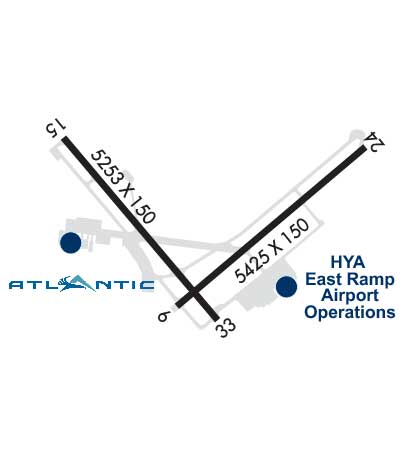
| Lat: N 4140.2 Long: W 07016.8 Elev: 54 Var: +16 Longest Runway: 5425 | ||
| Clr Del: 125.15 Dept. ATIS: 123.8 Arr. ATIS: 123.8 Ground: 118.45 Tower: 119.5 | ||
| |||||||||||||||||||||||||||||||||||||||||||||||||||||||||||||||||||||
| |||||||||||||||||||||||||||||||||||||||||||||||||||||||||||||||||||||
| |||||||||||||||||||||||||||||||||||||||||||||||||||||||||||||||||||||
| |||||||||||||||||||||||||||||||||||||||||||||||||||||||||||||||||||||
| |||||||||||||||||||||||||||||||||||||||||||||||||||||||||||||||||||||
| |||||||||||||||||||||||||||||||||||||||||||||||||||||||||||||||||||||
| Rwy | Rwy | |||||||
| 5425x150 | 5019' | 5425x150 | 5425' | 109.15 - 246° | ||||
| 5255x150 | 5255' | 108.95 - 156° | 5255x150 | 5105' | ||||
| Runway ID | Single Wheel | Double Wheel | Double Tandem Wheel | Dual Double Wheel |
| 06/24 | 30,000 | 108,000 | N/A | N/A |
| 15/33 | 30,000 | 108,000 | N/A | N/A |
| These numbers are Advisory and are not limits. The Airport Manager should have more accurate Weight Limits | ||||
 Airport Diagram might not be current. | |
| Facility Name: | CAPE COD GATEWAY |
| City Name: | HYANNIS |
| County: | BARNSTABLE |
| State abbrev: | MA |
| State Name: | MASSACHUSETTS |
| Ownership: | PUBLICLY OWNED |
| Use: | OPEN TO THE PUBLIC |
| Owner's Name: | TOWN OF BARNSTABLE |
| Address: | TOWN HALL 367 MAIN ST |
| HYANNIS, MA 02601 | |
| Owner's Phone: | 508-862-4600 |
| Manager's Name: | MICHAEL NELSON |
| Address: | 480 BARNSTABLE RD |
| HYANNIS, MA 02601 | |
| Phone: | 508-775-2020 |
| FAA Region: | NEW ENGLAND |
| FAA Field Office: | NONE |
| Date | Sunrise | Sunset |
|---|---|---|
| 06/08/26 Monday | 5:07 | 20:14 |
| 06/09/26 Tuesday | 5:07 | 20:14 |
| 06/10/26 Wednesday | 5:06 | 20:15 |
| 06/11/26 Thursday | 5:06 | 20:15 |
| 06/12/26 Friday | 5:06 | 20:16 |
| 06/13/26 Saturday | 5:06 | 20:16 |
| 06/14/26 Sunday | 5:06 | 20:17 |
| 06/15/26 Monday | 5:06 | 20:17 |
| 06/16/26 Tuesday | 5:06 | 20:18 |
| 06/17/26 Wednesday | 5:06 | 20:18 |
| 06/18/26 Thursday | 5:06 | 20:18 |
| 06/19/26 Friday | 5:06 | 20:19 |
| 06/20/26 Saturday | 5:06 | 20:19 |
| 06/21/26 Sunday | 5:07 | 20:19 |
| Airport Attendance Schedule | CONTINUOUS; AVGAS UNAVBL BTN 1900 & 0600 LCL DLY. CALL GRIFFIN AFT HRS 508-367-2140. |
| Airport Status | OPERATIONAL (This Status can change at any time - please check NOTAMS) |
| Airport Lighting Schedule | ACTVT MALSR RWY 15; MALSF RWY 24; HIRL RWYS 06/24 & 15/33 - CTAF. |
| Airport Storage Available | Tie Downs, Hanger |
| Extra Services Available | Air Freight, Avionics, Charter, Flight Instruction, Aircraft Rental, Aircraft Sales |
| Wind Indicator | YES - (lighted) |
| Control Tower | YES |
| CTAF Frequency | 119.500 |
| Unicom Frequency | 122.950 |
| Rotating Beacon Color | WG |
| Segmented Circle | YES |
| Landing Fee | NO; LDG FEE FOR ALL ACFT OVER 6000 LBS. |
| Airport Inspected | FEDERAL - performed by FAA AIRPORTS FIELD PERSONNEL |
| Inspection Date | 04/18/2025 |
| Type of Fuel Available | Grade 100LL, JET A (freeze point -40C) |
| Airframe Repair Service | MAJOR |
| Power Plant Repair Service | MAJOR |
| Latitude | N4140.2 |
| Longitude | W07016.8 (ESTIMATED) |
| Arpt Elevation | 54ft (SURVEYED) |
| Magnetic Variation | 16W |
| 1 miles N | of HYANNIS |
| Traffic Pattern Altitude | |
| Sectional Chart | NEW YORK |
| Operations (Reported) | Yearly | Avg. Daily |
|---|---|---|
| General Aviation Transient | 0 | 0 |
| General Aviation Local | 0 | 0 |
| Air Taxi | 0 | 0 |
| Commerical | 0 | 0 |
| Commuter | 0 | 0 |
| Military | 0 | 0 |
| Aircraft based on Field | |
|---|---|
| General Aviation Singles | 0 |
| General Aviation Multi | 0 |
| Jet Aircraft | 0 |
| General Aviation Helicopters | 0 |
| Military Aircraft | 0 |
| Gliders | 0 |
| Ultralights | 0 |
| FSS on field | NO |
| FSS tie-in | BRIDGEPORT |
| FSS Phone | 1-800-WX-BRIEF |
| Who issues Notams | HYA |
| Notam D service at airport | YES |
| ARTCC Name | BOSTON |
| Airport Certification | AIRPORT RECEIVING SCHEDULED AIR CARRIER SERVICE FROM CARRIERS CERTIFICATED BY THE CIVIL AERONAUTICS BOARD; CLSD TO UNSKED ACR OPS WITH MORE THAN 9 PAX SEATS 0000-0600 EXCP 1 HR PPR AMGR 508-778-7770. |
| Aircraft Rescue & Firefighting Index | AIRPORT HAS A CERTIFICATE UNDER CFR PART 139 |
| Airport of Entry | No |
| Custom Landing Rights | YES |
| Joint Civil/Military | No |
| Military Landing rights | YES |
| NATIONAL PLAN OF INTEGRATED AIRPORT SYSTEMS (NPIAS) |
| GRANT AGREEMENTS UNDER FAAP/ADAP/AIP |
| SURPLUS PROPERTY AGREEMENT UNDER PUBLIC LAW 289 |
| ASSURANCES PURSUANT TO TITLE VI, CIVIL RIGHTS ACT OF 1964 |
| AGREEMENT UNDER DLAND OR DCLA HAS EXPIRED. |
| ANT ON TANK 4600 FT SE ELEV 208 FT; STANDPIPE 7050 FT NORTH 236 FT; OBSTN LGTD. |
| TWY B CLSD TO ACFT WITH WINGSPAN GTR THAN 118 FT. TWY B BTN TWY D & RWY 6-24 CLSD TO ACFT WITH WINGSPAN GTR THAN 78 FT. |
| BE AWARE OF HIGH-SPD MIL JET & HVY HEL TFC VCNTY JOINT BASE CAPE COD. DO NOT CONFUSE JOINT BASE CAPE COD, 10NM W WITH CAPE COD GATEWAY. |
| ARFF INDEX B SVCS PRVDD BTN 0600 AND 2159 LCL DLY. ARFF INDEX A SVCS PRVDD DRG OTR TIMES. FOR INDEX B SVCS BTN 2200 AND 0559 LCL, 1HR 30MIN PPR AT 508-778-7770. |
| BIRDS, COYOTES ON & INVOF ARPT. |
| ARPT HAS NOISE ABATEMENT CTC AMGR 508-778-7765. |
| TGL OPS PROHIBITED BTN 2100-0559, PPR BY AMGR. |
| ALL TSNT & GA PILOTS MUST CTC ARPT OPS ON FREQ 122.95 PRIOR TO ENG SHTDN FOR AIRFIELD ESCORT BTN 2200-0559 LCL. |
| RWY 06/2 4 PCR VALUE: 384/F/A/X/T |
| RWY 15/3 3 PCR VALUE: 355/F/A/X/T |
Airport Communications & Frequencies:
| ||||||||||||||||||||||||||
| Runway: 06 | Runway: 24 | ||
| Mag heading: | 66° | Mag heading: | 246° |
| Rwy Slope: | -.10% Down | Rwy Slope: | .10% Up |
| Approach: | Approach: | ILS/DME | |
| Pattern: | Left Traffic | Pattern: | Left Traffic |
| Markings: | PRECISION INSTRUMENT | Markings: | PRECISION INSTRUMENT |
| Marking Condition: | GOOD | Marking Condition: | GOOD |
| Arresting Dev: | Arresting Dev: | EMAS; ENGINEERING MTRLS ARST SYS (EMAS) 200 FT IN LEN BY 176 FT WID LCTD AT THE DER 24. | |
| Lat & Long: | N4139.9 W07017.0 | Lat. & Long.: | N4140.5 W07016.1 |
| Elev: | 44.4 ft. MSL | Elev: | 39.1 ft. MSL |
| TCH: | 37 ft. AGL | TCH: | 50 ft. AGL |
| Visual Glide Path: | 3.00 degrees | Visual Glide Path: | 3.00 degrees |
| Displaced Threshold: | 406 feet | Displaced Threshold: | No |
| Touchdown Zone: | YES | Touchdown Zone: | YES |
| Touchdown Elev.: | 44.7 feet | Touchdown Elev.: | 43.1 feet |
| Visual Glide Slope: | 4-Light PAPI on LEFT side of Runway | Visual Glide Slope: | 4-Light PAPI on LEFT side of Runway |
| RVR Equipment: | ROLLOUT | RVR Equipment: | TOUCHDOWN |
| RVV Equipment: | NO | RVV Equipment: | YES |
| Approach Lights: | Approach Lights: | MALSF - 1,400 foot medium intensity approach lighting system with sequenced flashers | |
| REIL: | YES | REIL: | NO |
| Centerline Lights: | NO | Centerline Lights: | NO |
| Touchdown lights: | NO | Touchdown lights: | NO |
| Runway Category: | Runway with a Non-precision Approach having visibility minimums greater than 3/4 mile | Runway Category: | Precision Instrument Runway |
| Declared Distances: | TORA:5425' TODA:5425' ASDA:5425' LDA:5019' | Declared Distances: | TORA:5425' TODA:5425' ASDA:5425' LDA:5425' |
| Obstructions: | TREE | Obstructions: | RR |
| Marked: | NOT Marked/Lighted | Marked: | NOT Marked/Lighted |
| Clearance slope: | 14:1; APCH RATIO 50:1 TO DTHR. | Clearance slope: | 10:1 |
| Obstruction height: | 17 feet AGL | Obstruction height: | 20 feet AGL |
| Dist. from runway: | 450 feet | Dist. from runway: | 400 feet |
| Centerline offset: | 300 left of centerline | Centerline offset: | 300 feet left of centerline |
| Comments: | Comments: |
| Runway: 15 | Runway: 33 | ||
| Mag heading: | 156° | Mag heading: | 336° |
| Rwy Slope: | -.22% Down | Rwy Slope: | .22% Up |
| Approach: | ILS/DME | Approach: | |
| Pattern: | Left Traffic | Pattern: | Left Traffic |
| Markings: | PRECISION INSTRUMENT | Markings: | PRECISION INSTRUMENT |
| Marking Condition: | GOOD | Marking Condition: | GOOD |
| Arresting Dev: | Arresting Dev: | ||
| Lat & Long: | N4140.5 W07017.5 | Lat. & Long.: | N4139.8 W07016.8 |
| Elev: | 54.1 ft. MSL | Elev: | 42.4 ft. MSL |
| TCH: | TCH: | 53 ft. AGL | |
| Visual Glide Path: | Visual Glide Path: | 3.00 degrees | |
| Displaced Threshold: | No | Displaced Threshold: | 150 feet; APCH RATIO 34:1 TO DTHR. |
| Touchdown Zone: | YES | Touchdown Zone: | YES |
| Touchdown Elev.: | 54.1 feet | Touchdown Elev.: | 50.0 feet |
| Visual Glide Slope: | Visual Glide Slope: | 4-Light PAPI on LEFT side of Runway | |
| RVR Equipment: | TOUCHDOWN | RVR Equipment: | ROLLOUT |
| RVV Equipment: | NO | RVV Equipment: | NO |
| Approach Lights: | MALSR - 1,400 foot medium intensity approach lighting system with runway alignment indicator lights | Approach Lights: | |
| REIL: | NO | REIL: | NO |
| Centerline Lights: | NO | Centerline Lights: | NO |
| Touchdown lights: | NO | Touchdown lights: | NO |
| Runway Category: | Precision Instrument Runway | Runway Category: | Runway with a Non-precision Approach having visibility minimums greater than 3/4 mile |
| Declared Distances: | TORA:5255' TODA:5255' ASDA:5255' LDA:5255' | Declared Distances: | TORA:5255' TODA:5255' ASDA:5255' LDA:5105' |
| Obstructions: | PLINE | Obstructions: | |
| Marked: | LIGHTED | Marked: | |
| Clearance slope: | 34:1 | Clearance slope: | 34:1 |
| Obstruction height: | 146 feet AGL | Obstruction height: | |
| Dist. from runway: | 5175 feet | Dist. from runway: | |
| Centerline offset: | Centerline offset: | ||
| Comments: | Comments: |
Thanks for using FltPlan.com
all rights reserved © 1999-2026 by Flight Plan LLC


