
| HARTFORD MUNI HARTFORD WI |
| |
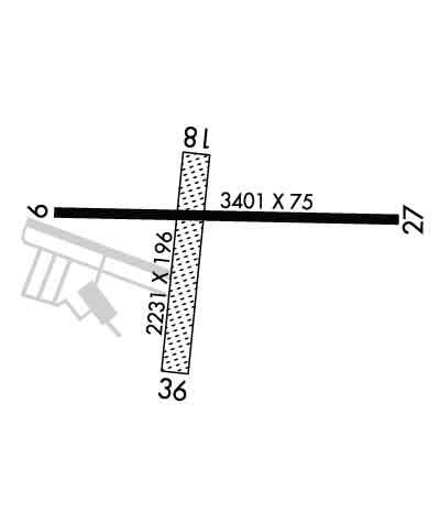
| Lat: N 4321.0 Long: W 08823.4 Elev: 1070 Var: +03 Longest Runway: 3401 | ||
| CTAF: 123.0 | ||
| ||||||
|
| Rwy | Rwy | |||||||
| 3401x75 | 3401' | 3401x75 | 3401' | |||||
| 2231x196 | 2231' | 2231x196 | 2231' | |||||
| Runway ID | Single Wheel | Double Wheel | Double Tandem Wheel | Dual Double Wheel |
| 09/27 | 8,000 | N/A | N/A | N/A |
| 18/36 | N/A | N/A | N/A | N/A |
| These numbers are Advisory and are not limits. The Airport Manager should have more accurate Weight Limits | ||||
 Airport Diagram might not be current. | |
| Facility Name: | HARTFORD MUNI |
| City Name: | HARTFORD |
| County: | WASHINGTON |
| State abbrev: | WI |
| State Name: | WISCONSIN |
| Ownership: | PUBLICLY OWNED |
| Use: | OPEN TO THE PUBLIC |
| Owner's Name: | CITY OF HARTFORD |
| Address: | 109 N. MAIN |
| HARTFORD, WI 53027 | |
| Owner's Phone: | 262-673-8263 |
| Manager's Name: | DARRYL KRANZ |
| Address: | 109 N MAIN; EMAIL ADDRESS: DKRANZ@CI.HARTFORD.WI.US (ALL LOWER CASE) |
| HARTFORD, WI 53027 | |
| Phone: | 262-673-8225 |
| FAA Region: | GREAT LAKES |
| FAA Field Office: | CHI |
| Date | Sunrise | Sunset |
|---|---|---|
| 09/24/21 Friday | 6:43 | 18:48 |
| 09/25/21 Saturday | 6:44 | 18:46 |
| 09/26/21 Sunday | 6:45 | 18:44 |
| 09/27/21 Monday | 6:46 | 18:42 |
| 09/28/21 Tuesday | 6:47 | 18:40 |
| 09/29/21 Wednesday | 6:48 | 18:39 |
| 09/30/21 Thursday | 6:50 | 18:37 |
| 10/01/21 Friday | 6:51 | 18:35 |
| 10/02/21 Saturday | 6:52 | 18:33 |
| 10/03/21 Sunday | 6:53 | 18:31 |
| 10/04/21 Monday | 6:54 | 18:30 |
| 10/05/21 Tuesday | 6:55 | 18:28 |
| 10/06/21 Wednesday | 6:56 | 18:26 |
| 10/07/21 Thursday | 6:58 | 18:24 |
| Airport Attendance Schedule | UNATTENDED |
| Airport Status | OPERATIONAL (This Status can change at any time - please check NOTAMS) |
| Airport Lighting Schedule | ACTVT REIL RWY 9 & 27; MIRL RWY 9/27 - CTAF |
| Airport Storage Available | Tie Downs, Hanger |
| Extra Services Available | Glider, Flight Instruction, Aircraft Rental, Glider Towing |
| Wind Indicator | YES - (lighted) |
| Control Tower | NO |
| CTAF Frequency | 123.000 |
| Unicom Frequency | 123.000 |
| Rotating Beacon Color | CLEAR-GREEN (Light Land Airport) |
| Segmented Circle | YES |
| Landing Fee | NO |
| Airport Inspected | STATE - performed by STATE AERONAUTICAL PERSONNEL |
| Inspection Date | 09/09/2019 |
| Type of Fuel Available | Grade 100LLMOGAS; -1024 HR FUEL AVBL WITH CREDIT CARD. |
| Airframe Repair Service | NONE |
| Power Plant Repair Service | NONE |
| Latitude | N4321.0 |
| Longitude | W08823.4 (ESTIMATED) |
| Arpt Elevation | 1070ft (SURVEYED) |
| Magnetic Variation | 03W |
| 2 miles NW | of HARTFORD |
| Traffic Pattern Altitude | 500; TPA: 500 FT AGL ULTRALIGHTS. |
| Sectional Chart | CHICAGO |
| Operations (Reported) | Yearly | Avg. Daily |
|---|---|---|
| General Aviation Transient | 5000 | 14 |
| General Aviation Local | 10000 | 27 |
| Air Taxi | 400 | 1 |
| Commerical | 0 | 0 |
| Commuter | 0 | 0 |
| Military | 100 | 0 |
| Aircraft based on Field | |
|---|---|
| General Aviation Singles | 81 |
| General Aviation Multi | 1 |
| Jet Aircraft | 1 |
| General Aviation Helicopters | 3 |
| Military Aircraft | 0 |
| Gliders | 11 |
| Ultralights | 0 |
| FSS on field | NO |
| FSS tie-in | GREEN BAY |
| FSS Phone | 1-800-WX-BRIEF |
| Who issues Notams | GRB |
| Notam D service at airport | YES |
| ARTCC Name | CHICAGO |
| Airport Certification | |
| Aircraft Rescue & Firefighting Index | None |
| Airport of Entry | No |
| Custom Landing Rights | No |
| Joint Civil/Military | No |
| Military Landing rights | YES |
| NATIONAL PLAN OF INTEGRATED AIRPORT SYSTEMS (NPIAS) |
| GRANT AGREEMENTS UNDER FAAP/ADAP/AIP |
| ASSURANCES PURSUANT TO TITLE VI, CIVIL RIGHTS ACT OF 1964 |
| GLIDER & ULTRALIGHT ACTVTY ON ARPT. |
| (A23) RIGHT TFC PAT ULTRALIGHT & GLIDER ACFT. |
| FOR CD CTC CHICAGO ARTCC AT 630-906-8921. |
| RWY 18 SLIGHT DOWNHILL SLOPE. |
| RWY 36 +78 FT WATER TWR 3885 FT FM APCH END. |
Airport Communications & Frequencies:
| ||||||||||||||
| Runway: 09 | Runway: 27 | ||
| Mag heading: | 94° | Mag heading: | 274° |
| Rwy Slope: | .57% Up | Rwy Slope: | -.57% Down |
| Approach: | Approach: | ||
| Pattern: | Left Traffic | Pattern: | Left Traffic |
| Markings: | NONPRECISION INSTRUMENT | Markings: | NONPRECISION INSTRUMENT |
| Marking Condition: | GOOD | Marking Condition: | GOOD |
| Arresting Dev: | Arresting Dev: | ||
| Lat & Long: | N4321.0 W08823.8 | Lat. & Long.: | N4321.0 W08823.0 |
| Elev: | 1050.6 ft. MSL | Elev: | 1070.0 ft. MSL |
| TCH: | 40 ft. AGL | TCH: | 40 ft. AGL |
| Visual Glide Path: | 3.00 degrees | Visual Glide Path: | 3.00 degrees |
| Displaced Threshold: | No | Displaced Threshold: | No |
| Touchdown Zone: | YES | Touchdown Zone: | YES |
| Touchdown Elev.: | 1067.8 feet | Touchdown Elev.: | 1070.0 feet |
| Visual Glide Slope: | 4-Light PAPI on LEFT side of Runway | Visual Glide Slope: | 4-Light PAPI on LEFT side of Runway |
| RVR Equipment: | RVR Equipment: | ||
| RVV Equipment: | NO | RVV Equipment: | NO |
| Approach Lights: | Approach Lights: | ||
| REIL: | YES | REIL: | YES |
| Centerline Lights: | NO | Centerline Lights: | NO |
| Touchdown lights: | NO | Touchdown lights: | NO |
| Runway Category: | Runway with a Non-precision Approach | Runway Category: | Runway with a Non-precision Approach |
| Declared Distances: | Declared Distances: |
| Runway: 18 | Runway: 36 | ||
| Mag heading: | 188° | Mag heading: | 8° |
| Rwy Slope: | -1.51% Down | Rwy Slope: | 1.51% Up |
| Approach: | Approach: | ||
| Pattern: | Left Traffic | Pattern: | Left Traffic |
| Markings: | Markings: | ||
| Marking Condition: | THR MARKED WITH ORANGE & WHITE WOODEN A-FRAMES. | Marking Condition: | THR MARKED WITH ORANGE & WHITE WOODEN A-FRAMES. |
| Arresting Dev: | Arresting Dev: | ||
| Lat & Long: | N4321.1 W08823.4 | Lat. & Long.: | N4320.8 W08823.5 |
| Elev: | 1069.5 ft. MSL | Elev: | 1035.8 ft. MSL |
| TCH: | TCH: | ||
| Visual Glide Path: | Visual Glide Path: | ||
| Displaced Threshold: | No | Displaced Threshold: | No |
| Touchdown Zone: | YES | Touchdown Zone: | YES |
| Touchdown Elev.: | 1069.5 feet | Touchdown Elev.: | 1069.5 feet |
| Visual Glide Slope: | Visual Glide Slope: | ||
| RVR Equipment: | RVR Equipment: | ||
| RVV Equipment: | NO | RVV Equipment: | NO |
| Approach Lights: | Approach Lights: | ||
| REIL: | NO | REIL: | NO |
| Centerline Lights: | NO | Centerline Lights: | NO |
| Touchdown lights: | NO | Touchdown lights: | NO |
| Runway Category: | Runway with a Visual Approach | Runway Category: | Runway with a Visual Approach |
| Declared Distances: | Declared Distances: | ||
| Obstructions: | ROAD | Obstructions: | TREES |
| Marked: | NOT Marked/Lighted | Marked: | NOT Marked/Lighted |
| Clearance slope: | 27:1 | Clearance slope: | 25:1 |
| Obstruction height: | 21 feet AGL | Obstruction height: | 52 feet AGL |
| Dist. from runway: | 580 feet | Dist. from runway: | 1300 feet |
| Centerline offset: | 180 left of centerline | Centerline offset: | 100 feet left of centerline |
| Comments: | Comments: |
Thanks for using FltPlan.com
all rights reserved © 1999-2021 by Flight Plan LLC
