
| HILTON HEAD HILTON HEAD ISLAND SC |
| |
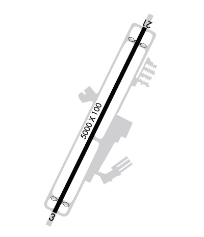
| Lat: N 3213.5 Long: W 08041.8 Elev: 19 Var: +07 Longest Runway: 5000 | ||
| Clr Del: 121.1 Dept. ATIS: 121.4 Arr. ATIS: 121.4 AWOS: 121.4 Ground: 121.1 Tower: 118.97 | ||
| ||||||||||||||||||||||||||||||||||||||||||||
| ||||||||||||||||||||||||||||||||||||||||||||
| ||||||||||||||||||||||||||||||||||||||||||||
| Rwy | Rwy | |||||||
| 5000x100 | 4703' | 5000x100 | 4597' | 111.30 - 213° | ||||
| Runway ID | Single Wheel | Double Wheel | Double Tandem Wheel | Dual Double Wheel |
| 03/21 | 55,000 | 75,000 | N/A | N/A |
| These numbers are Advisory and are not limits. The Airport Manager should have more accurate Weight Limits | ||||
 Airport Diagram might not be current. | |
| Facility Name: | HILTON HEAD |
| City Name: | HILTON HEAD ISLAND |
| County: | BEAUFORT |
| State abbrev: | SC |
| State Name: | SOUTH CAROLINA |
| Ownership: | PUBLICLY OWNED |
| Use: | OPEN TO THE PUBLIC |
| Owner's Name: | BEAUFORT COUNTY |
| Address: | 120 BEACH CITY ROAD |
| HILTON HEAD ISLAND, SC 29926 | |
| Owner's Phone: | 843-255-2950 |
| Manager's Name: | JON REMBOLD |
| Address: | 120 BEACH CITY ROAD |
| HILTON HEAD ISLAND, SC 29926 | |
| Phone: | 843-255-2952 |
| FAA Region: | SOUTHERN |
| FAA Field Office: | ATL |

| Date | Sunrise | Sunset |
|---|---|---|
| 09/24/21 Friday | 7:12 | 19:17 |
| 09/25/21 Saturday | 7:13 | 19:16 |
| 09/26/21 Sunday | 7:13 | 19:14 |
| 09/27/21 Monday | 7:14 | 19:13 |
| 09/28/21 Tuesday | 7:15 | 19:12 |
| 09/29/21 Wednesday | 7:15 | 19:10 |
| 09/30/21 Thursday | 7:16 | 19:09 |
| 10/01/21 Friday | 7:17 | 19:08 |
| 10/02/21 Saturday | 7:17 | 19:07 |
| 10/03/21 Sunday | 7:18 | 19:05 |
| 10/04/21 Monday | 7:19 | 19:04 |
| 10/05/21 Tuesday | 7:19 | 19:03 |
| 10/06/21 Wednesday | 7:20 | 19:01 |
| 10/07/21 Thursday | 7:21 | 19:00 |
| Airport Attendance Schedule | 7 Days A Week 0600-2200 |
| Airport Status | OPERATIONAL (This Status can change at any time - please check NOTAMS) |
| Airport Lighting Schedule | ACTVT MIRL 03/21 AND REIL RYS 03 & 21 - CTAF. |
| Airport Storage Available | Tie Downs |
| Extra Services Available | Air Ambulance, Avionics, Charter, Flight Instruction, Aircraft Rental |
| Wind Indicator | YES - (lighted) |
| Control Tower | YES |
| CTAF Frequency | 118.975 |
| Unicom Frequency | |
| Rotating Beacon Color | CLEAR-GREEN (Light Land Airport) |
| Segmented Circle | YES |
| Landing Fee | NO |
| Airport Inspected | FEDERAL - performed by FAA AIRPORTS FIELD PERSONNEL |
| Inspection Date | 08/07/2019 |
| Type of Fuel Available | Grade 100LL, JET A (freeze point -40C) |
| Airframe Repair Service | MAJOR |
| Power Plant Repair Service | MAJOR |
| Latitude | N3213.5 |
| Longitude | W08041.8 (ESTIMATED) |
| Arpt Elevation | 19ft (SURVEYED) |
| Magnetic Variation | 07W |
| 3 miles E | of HILTON HEAD ISLAND |
| Traffic Pattern Altitude | |
| Sectional Chart | CHARLOTTE |
| Operations (Reported) | Yearly | Avg. Daily |
|---|---|---|
| General Aviation Transient | 26746 | 73 |
| General Aviation Local | 3588 | 10 |
| Air Taxi | 6476 | 18 |
| Commerical | 0 | 0 |
| Commuter | 0 | 0 |
| Military | 822 | 2 |
| Aircraft based on Field | |
|---|---|
| General Aviation Singles | 55 |
| General Aviation Multi | 23 |
| Jet Aircraft | 8 |
| General Aviation Helicopters | 2 |
| Military Aircraft | 0 |
| Gliders | 0 |
| Ultralights | 1 |
| FSS on field | NO |
| FSS tie-in | ANDERSON |
| FSS Phone | 1-800-WX-BRIEF |
| Who issues Notams | HXD |
| Notam D service at airport | YES |
| ARTCC Name | JACKSONVILLE |
| Airport Certification | AIRPORT RECEIVING SCHEDULED AIR CARRIER SERVICE FROM CARRIERS CERTIFICATED BY THE CIVIL AERONAUTICS BOARD; CLSD TO UNSKED ACR OPNS WITH MORE THAN 30 PSGR SEATS EXCP 24 HRS PPR CALL AMGR (843) 255-2950 |
| Aircraft Rescue & Firefighting Index | AIRPORT HAS A CERTIFICATE UNDER CFR PART 139 |
| Airport of Entry | No |
| Custom Landing Rights | No |
| Joint Civil/Military | No |
| Military Landing rights | YES |
| NATIONAL PLAN OF INTEGRATED AIRPORT SYSTEMS (NPIAS) |
| GRANT AGREEMENTS UNDER FAAP/ADAP/AIP |
| ASSURANCES PURSUANT TO TITLE VI, CIVIL RIGHTS ACT OF 1964 |
| NOISE ABATEMENT PROCS IN EFC, CTC OPS (843) 255-2960. |
| BIRDS ON & INVOF ARPT. |
| PARASAIL OPNS WITHIN 3 NM RADIUS OF SAV 009 DEGS/15 NM, SFC TO 1500 DURG DALGT HRS. |
| DEER ON AND INVOF ARPT. |
Airport Communications & Frequencies:
| |||||||||||||||||||||||
| Runway: 03 | Runway: 21 | ||
| Mag heading: | 33° | Mag heading: | 213° |
| Rwy Slope: | -.15% Down | Rwy Slope: | .15% Up |
| Approach: | Approach: | LOC/DME | |
| Pattern: | Left Traffic | Pattern: | Left Traffic |
| Markings: | NONPRECISION INSTRUMENT | Markings: | NONPRECISION INSTRUMENT |
| Marking Condition: | GOOD | Marking Condition: | GOOD |
| Arresting Dev: | EMAS; ENGINEERED MATERIALS ARRESTING SYSTEM (EMAS) 207 FT IN LENGTH BY 105 FT IN WIDTH LCTD AT THE DER 03. | Arresting Dev: | EMAS; ENGINEERED MATERIALS ARRESTING SYSTEM (EMAS) 211 FT IN LENGTH BY 105 FT IN WIDTH LCTD AT THE DER 21. |
| Lat & Long: | N3213.1 W08042.1 | Lat. & Long.: | N3213.8 W08041.6 |
| Elev: | 18.9 ft. MSL | Elev: | 11.2 ft. MSL |
| TCH: | 40 ft. AGL | TCH: | 40 ft. AGL |
| Visual Glide Path: | 3.00 degrees | Visual Glide Path: | 3.00 degrees |
| Displaced Threshold: | 297 feet | Displaced Threshold: | 403 feet |
| Touchdown Zone: | YES | Touchdown Zone: | YES |
| Touchdown Elev.: | 19.4 feet | Touchdown Elev.: | 18.2 feet |
| Visual Glide Slope: | 4-Light PAPI on LEFT side of Runway; PAPI UNUSBL BYD 7 DEGS LEFT OF CNTRLN. | Visual Glide Slope: | 4-Light PAPI on RIGHT side of Runway |
| RVR Equipment: | RVR Equipment: | ||
| RVV Equipment: | NO | RVV Equipment: | NO |
| Approach Lights: | Approach Lights: | ||
| REIL: | YES | REIL: | YES |
| Centerline Lights: | NO | Centerline Lights: | NO |
| Touchdown lights: | NO | Touchdown lights: | NO |
| Runway Category: | Runway with a Non-precision Approach having visibility minimums greater than 3/4 mile | Runway Category: | Runway with a Non-precision Approach having visibility minimums greater than 3/4 mile |
| Declared Distances: | TORA:5000' TODA:5000' ASDA:5000' LDA:4703' | Declared Distances: | TORA:5000' TODA:5000' ASDA:5000' LDA:4597' |
| Obstructions: | TREE | Obstructions: | TREE |
| Marked: | NOT Marked/Lighted | Marked: | NOT Marked/Lighted |
| Clearance slope: | 20:1 | Clearance slope: | 20:1; 33:1 TO DSPLCD THLD ; TREES AT 1600 FT. |
| Obstruction height: | 56 feet AGL | Obstruction height: | 55 feet AGL |
| Dist. from runway: | 1325 feet | Dist. from runway: | 1300 feet |
| Centerline offset: | 250 right of centerline | Centerline offset: | 225 feet right of centerline |
| Comments: | Comments: |
Thanks for using FltPlan.com
all rights reserved © 1999-2021 by Flight Plan LLC