| HAYWARD EXECUTIVE HAYWARD CA |
| |
| Lat: N 3739.5 Long: W 12207.3 Elev: 52 Var: -15 Longest Runway: 5694 | ||
| Clr Del: 128.05 Dept. ATIS: 126.7 Arr. ATIS: 126.7 AWOS: 126.7 Ground: 121.4 Tower: 120.2/118.9 | ||

| |||||||||||||||||||||||||||||||||||||||||||||||||||||||||||||||||||||
| |||||||||||||||||||||||||||||||||||||||||||||||||||||||||||||||||||||
| |||||||||||||||||||||||||||||||||||||||||||||||||||||||||||||||||||||
| |||||||||||||||||||||||||||||||||||||||||||||||||||||||||||||||||||||
| |||||||||||||||||||||||||||||||||||||||||||||||||||||||||||||||||||||
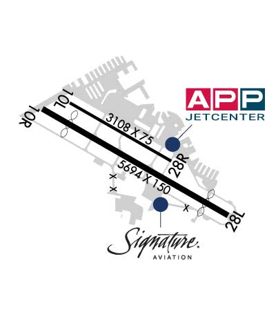
| Rwy | Rwy | |||||||
| 3108x75 | 3108' | 3108x75 | 3108' | |||||
| 5694x150 | 4868' | 5694x150 | 5018' | 111.50 - 287° | ||||
| Runway ID | Single Wheel | Double Wheel | Double Tandem Wheel | Dual Double Wheel |
| 10L/28R | 13,000 | N/A | N/A | N/A |
| 10R/28L | 30,000 | 75,000 | N/A | N/A |
| These numbers are Advisory and are not limits. The Airport Manager should have more accurate Weight Limits | ||||
 Airport Diagram might not be current. | |
| Facility Name: | HAYWARD EXEC |
| City Name: | HAYWARD |
| County: | ALAMEDA |
| State abbrev: | CA |
| State Name: | CALIFORNIA |
| Ownership: | PUBLICLY OWNED |
| Use: | OPEN TO THE PUBLIC |
| Owner's Name: | CITY OF HAYWARD; CITY MANAGER |
| Address: | 777 B ST |
| HAYWARD, CA 94541 | |
| Owner's Phone: | 510-583-4310 |
| Manager's Name: | DOUG MCNEELEY |
| Address: | 20301 SKYWEST DR |
| HAYWARD, CA 94541-4699 | |
| Phone: | (510) 293-8678 |
| FAA Region: | WESTERN-PACIFIC |
| FAA Field Office: | SFO |
| Date | Sunrise | Sunset |
|---|---|---|
| 06/08/26 Monday | 5:47 | 20:29 |
| 06/09/26 Tuesday | 5:47 | 20:29 |
| 06/10/26 Wednesday | 5:46 | 20:30 |
| 06/11/26 Thursday | 5:46 | 20:30 |
| 06/12/26 Friday | 5:46 | 20:30 |
| 06/13/26 Saturday | 5:46 | 20:31 |
| 06/14/26 Sunday | 5:46 | 20:31 |
| 06/15/26 Monday | 5:46 | 20:32 |
| 06/16/26 Tuesday | 5:46 | 20:32 |
| 06/17/26 Wednesday | 5:46 | 20:32 |
| 06/18/26 Thursday | 5:47 | 20:33 |
| 06/19/26 Friday | 5:47 | 20:33 |
| 06/20/26 Saturday | 5:47 | 20:33 |
| 06/21/26 Sunday | 5:47 | 20:33 |
| Airport Attendance Schedule | 7 Days A Week 0800-1700 |
| Airport Status | OPERATIONAL (This Status can change at any time - please check NOTAMS) |
| Airport Lighting Schedule | WHEN ATCT CLSD MIRL RWY 10R/28L PRESET LOW INTST; TO INCREASE INTST ACTVT - CTAF. WHEN ATCT CLSD VASI RWY 10R & 28L OPER SS-SR; PAPI RWY 10L & 28R, REIL RWY 10R & 28L UNAVBL. |
| Airport Storage Available | Tie Downs |
| Extra Services Available | Charter, Flight Instruction, Aircraft Rental |
| Wind Indicator | YES - (lighted) |
| Control Tower | YES |
| CTAF Frequency | 120.200 |
| Unicom Frequency | 122.950 |
| Rotating Beacon Color | WG |
| Segmented Circle | YES |
| Landing Fee | NO |
| Airport Inspected | STATE - performed by STATE AERONAUTICAL PERSONNEL |
| Inspection Date | 01/14/2025 |
| Type of Fuel Available | Grade 100LL, JET A (freeze point -40C)UL94; -ULAVBL AT SELF-SERVE ISLAND. |
| Airframe Repair Service | MAJOR |
| Power Plant Repair Service | MAJOR |
| Latitude | N3739.5 |
| Longitude | W12207.3 (ESTIMATED) |
| Arpt Elevation | 52ft (SURVEYED) |
| Magnetic Variation | 15E |
| 2 miles W | of HAYWARD |
| Traffic Pattern Altitude | |
| Sectional Chart | SAN FRANCISCO |
| Operations (Reported) | Yearly | Avg. Daily |
|---|---|---|
| General Aviation Transient | 0 | 0 |
| General Aviation Local | 0 | 0 |
| Air Taxi | 0 | 0 |
| Commerical | 0 | 0 |
| Commuter | 0 | 0 |
| Military | 0 | 0 |
| Aircraft based on Field | |
|---|---|
| General Aviation Singles | 0 |
| General Aviation Multi | 0; INCLUDES 1 AMPHIBIAN. |
| Jet Aircraft | 0 |
| General Aviation Helicopters | 0 |
| Military Aircraft | 0 |
| Gliders | 0 |
| Ultralights | 0 |
| FSS on field | NO |
| FSS tie-in | OAKLAND |
| FSS Phone | 1-800-WX-BRIEF |
| Who issues Notams | HWD |
| Notam D service at airport | YES |
| ARTCC Name | OAKLAND |
| Airport Certification | |
| Aircraft Rescue & Firefighting Index | None |
| Airport of Entry | No |
| Custom Landing Rights | No |
| Joint Civil/Military | No |
| Military Landing rights | YES |
| NATIONAL PLAN OF INTEGRATED AIRPORT SYSTEMS (NPIAS) |
| GRANT AGREEMENTS UNDER FAAP/ADAP/AIP |
| SURPLUS PROPERTY AGREEMENT UNDER PUBLIC LAW 289 |
| SURPLUS PROPERTY AGREEMENT UNDER REGULATION 16-WAA |
| ASSURANCES PURSUANT TO TITLE VI, CIVIL RIGHTS ACT OF 1964 |
| 155 FT ENERGY COMPLEX EXHAUST STACK 1 1/2 NM SW OF ARPT. DO NOT OVERFLY ENERGY COMPLEX FACILITY BELOW 1,000 FT MSL. |
| TWY Z1 CLSD TO ACFT WITH WINGSPAN GTR THAN 94 FT. |
| TWY A NOT VSB FM ATCT BTB TWY B & C |
| FOR CD WHEN ATCT IS CLSD CTC NORCAL APCH AT 916-361-0516. |
| TWY A1 CLSD TO ACFT WITH WINGSPAN GTR THAN 100 FT. |
| WHEN ATCT CLSD RWY 10L/28R CLSD. |
| RY 10R HAS LANDING DISTANCE REMAINING SIGNS (LGTD) NORTH SIDE OF RY. |
| RY 28L HAS LANDING DISTANCE REMAINING SIGNS (LGTD) SOUTH SIDE OF RY. |
| FLOCKS OF BIRDS FEEDING ALONG THE SHORELINE, CREEK AREAS AND AT THE GOLF COURSE TO THE NORTH, ON OCCASION MAY FLY ACROSS VARIOUS PARTS OF THE ARPT. |
| NOISE ABATEMENT PROCEDURES IN EFFECT CTC ARPT FOR NOISE RULES 510-293-8669. |
| TRANSIENT HELICOPTER TFC USE HELIPADS WEST OF GREEN RAMP LCTD AT BASE OF ATCT. |
| RWY 10R/ 28LSTRENGTH LIMITED BY STRENGTH OF CONNECTING TAXIWAYS. |
Airport Communications & Frequencies:
| |||||||||||||||||||||||||||||||||||||||||
| Runway: 10L | Runway: 28R | ||
| Mag heading: | 105° | Mag heading: | 285° |
| Rwy Slope: | .29% Up | Rwy Slope: | -.29% Down |
| Approach: | Approach: | ||
| Pattern: | Left Traffic | Pattern: | Right Traffic |
| Markings: | NONPRECISION INSTRUMENT | Markings: | NONPRECISION INSTRUMENT |
| Marking Condition: | GOOD | Marking Condition: | GOOD |
| Arresting Dev: | Arresting Dev: | ||
| Lat & Long: | N3739.7 W12207.6 | Lat. & Long.: | N3739.5 W12207.1 |
| Elev: | 28.1 ft. MSL | Elev: | 37.1 ft. MSL |
| TCH: | 29 ft. AGL | TCH: | 44 ft. AGL |
| Visual Glide Path: | 3.00 degrees | Visual Glide Path: | 3.00 degrees |
| Displaced Threshold: | No | Displaced Threshold: | No |
| Touchdown Zone: | YES | Touchdown Zone: | YES |
| Touchdown Elev.: | 36.9 feet | Touchdown Elev.: | 37.2 feet |
| Visual Glide Slope: | 4-Light PAPI on LEFT side of Runway | Visual Glide Slope: | 4-Light PAPI on LEFT side of Runway |
| RVR Equipment: | RVR Equipment: | ||
| RVV Equipment: | NO | RVV Equipment: | NO |
| Approach Lights: | Approach Lights: | ||
| REIL: | NO | REIL: | NO |
| Centerline Lights: | NO | Centerline Lights: | NO |
| Touchdown lights: | NO | Touchdown lights: | NO |
| Runway Category: | Runway with a Visual Approach | Runway Category: | Runway with a Visual Approach |
| Declared Distances: | Declared Distances: | ||
| Obstructions: | TREE | Obstructions: | |
| Marked: | NOT Marked/Lighted | Marked: | |
| Clearance slope: | 14:1 | Clearance slope: | 50:1 |
| Obstruction height: | 60 feet AGL | Obstruction height: | |
| Dist. from runway: | 1085 feet | Dist. from runway: | |
| Centerline offset: | 143 left of centerline | Centerline offset: | |
| Comments: | Comments: |
| Runway: 10R | Runway: 28L | ||
| Mag heading: | 105° | Mag heading: | 285° |
| Rwy Slope: | .43% Up | Rwy Slope: | -.43% Down |
| Approach: | Approach: | LOC/DME | |
| Pattern: | Right Traffic | Pattern: | Left Traffic |
| Markings: | PRECISION INSTRUMENT | Markings: | PRECISION INSTRUMENT |
| Marking Condition: | GOOD | Marking Condition: | GOOD |
| Arresting Dev: | Arresting Dev: | ||
| Lat & Long: | N3739.7 W12207.8 | Lat. & Long.: | N3739.3 W12206.8 |
| Elev: | 27.7 ft. MSL | Elev: | 52.1 ft. MSL |
| TCH: | 25 ft. AGL | TCH: | 35 ft. AGL |
| Visual Glide Path: | 3.00 degrees | Visual Glide Path: | 4.00 degrees |
| Displaced Threshold: | 826 feet | Displaced Threshold: | 676 feet |
| Touchdown Zone: | YES | Touchdown Zone: | YES |
| Touchdown Elev.: | 41.7 feet | Touchdown Elev.: | 50.0 feet |
| Visual Glide Slope: | 4-BOX VASI ON RIGHT SIDE OF RUNWAY | Visual Glide Slope: | 4-BOX VASI ON LEFT SIDE OF RUNWAY |
| RVR Equipment: | RVR Equipment: | ||
| RVV Equipment: | NO | RVV Equipment: | NO |
| Approach Lights: | Approach Lights: | ||
| REIL: | YES | REIL: | YES |
| Centerline Lights: | NO | Centerline Lights: | NO |
| Touchdown lights: | NO | Touchdown lights: | NO |
| Runway Category: | Runway with a Visual Approach | Runway Category: | Runway with a Non-precision Approach having visibility minimums greater than 3/4 mile |
| Declared Distances: | Declared Distances: | ||
| Obstructions: | TREE | Obstructions: | Unknown |
| Marked: | NOT Marked/Lighted | Marked: | NOT Marked/Lighted |
| Clearance slope: | 20:1; APCH RATIO 45:1 FM DSPLCD THR. | Clearance slope: | 50:1 |
| Obstruction height: | 40 feet AGL | Obstruction height: | 0 feet AGL |
| Dist. from runway: | 1000 feet | Dist. from runway: | |
| Centerline offset: | 250 left of centerline | Centerline offset: | |
| Comments: | Comments: |
Thanks for using FltPlan.com
all rights reserved © 1999-2026 by Flight Plan LLC