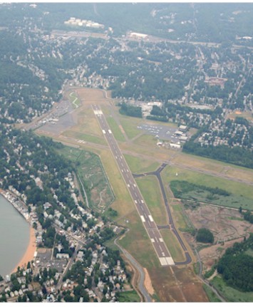
| TWEED-NEW HAVEN NEW HAVEN CT |
| |
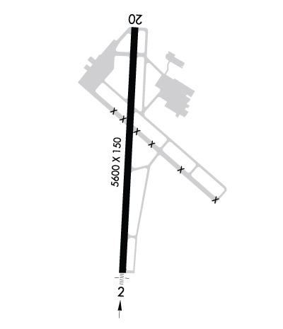
| Lat: N 4115.8 Long: W 07253.2 Elev: 13 Var: +13 Longest Runway: 5600 | ||
| Clr Del: 121.7 TWR CLD Dept. ATIS: 133.65 Arr. ATIS: 133.65 Ground: 121.7 Tower: 124.8 | ||
| |||||||||||||||||||||||||||||||||||||||||||||||||||||||||||||||||||||
| |||||||||||||||||||||||||||||||||||||||||||||||||||||||||||||||||||||
| |||||||||||||||||||||||||||||||||||||||||||||||||||||||||||||||||||||
| Rwy | Rwy | |||||||
| 5600x150 | 5600' | 109.10 - 016° | 5600x150 | 5248' | ||||
| 3626x100 | 3265' | 3626x100 | 3326' | |||||
| Runway ID | Single Wheel | Double Wheel | Double Tandem Wheel | Dual Double Wheel |
| 02/20 | 110,000 | 160,000 | N/A | N/A |
| 14/32 | 30,000 | 60,000 | N/A | N/A |
| These numbers are Advisory and are not limits. The Airport Manager should have more accurate Weight Limits | ||||
 Airport Diagram might not be current. | |
| Facility Name: | TWEED-NEW HAVEN |
| City Name: | NEW HAVEN |
| County: | NEW HAVEN |
| State abbrev: | CT |
| State Name: | CONNECTICUT |
| Ownership: | PUBLICLY OWNED |
| Use: | OPEN TO THE PUBLIC |
| Owner's Name: | CITY OF NEW HAVEN |
| Address: | 155 BURR STREET |
| NEW HAVEN, CT 06510 | |
| Owner's Phone: | 203-466-8833 |
| Manager's Name: | JEREMY NIELSON |
| Address: | 155 BURR ST |
| NEW HAVEN, CT 06512 | |
| Phone: | 203-466-8833 |
| FAA Region: | NEW ENGLAND |
| FAA Field Office: | NONE |
| Date | Sunrise | Sunset |
|---|---|---|
| 09/24/21 Friday | 6:41 | 18:46 |
| 09/25/21 Saturday | 6:42 | 18:44 |
| 09/26/21 Sunday | 6:43 | 18:42 |
| 09/27/21 Monday | 6:44 | 18:41 |
| 09/28/21 Tuesday | 6:45 | 18:39 |
| 09/29/21 Wednesday | 6:46 | 18:37 |
| 09/30/21 Thursday | 6:47 | 18:36 |
| 10/01/21 Friday | 6:48 | 18:34 |
| 10/02/21 Saturday | 6:49 | 18:32 |
| 10/03/21 Sunday | 6:50 | 18:31 |
| 10/04/21 Monday | 6:51 | 18:29 |
| 10/05/21 Tuesday | 6:52 | 18:27 |
| 10/06/21 Wednesday | 6:53 | 18:26 |
| 10/07/21 Thursday | 6:54 | 18:24 |
| Airport Attendance Schedule | 7 Days A Week 0600-2200; FUEL AVBL AFT HRS PPR 203-467-9555. |
| Airport Status | OPERATIONAL (This Status can change at any time - please check NOTAMS) |
| Airport Lighting Schedule | WHEN ATCT CLSD ACTVT MALSF RWY 02; HIRL RWY 02/20 - CTAF. |
| Airport Storage Available | Tie Downs, Hanger |
| Extra Services Available | Charter, Flight Instruction, Aircraft Rental, Aircraft Sales |
| Wind Indicator | YES - (lighted) |
| Control Tower | YES |
| CTAF Frequency | 124.800 |
| Unicom Frequency | 122.950 |
| Rotating Beacon Color | CLEAR-GREEN (Light Land Airport) |
| Segmented Circle | YES |
| Landing Fee | YES; LDG FEE FOR ALL ACFT EXC MIL, GOVT, EMERG & MED. |
| Airport Inspected | FEDERAL - performed by FAA AIRPORTS FIELD PERSONNEL |
| Inspection Date | 06/15/2021 |
| Type of Fuel Available | Grade 100LL, JET A (freeze point -40C) |
| Airframe Repair Service | MAJOR |
| Power Plant Repair Service | MAJOR |
| Latitude | N4115.8 |
| Longitude | W07253.2 (ESTIMATED) |
| Arpt Elevation | 12ft (SURVEYED) |
| Magnetic Variation | 13W |
| 3 miles SE | of NEW HAVEN |
| Traffic Pattern Altitude | 999; TPA: 999 FT AGL RECIPROCATING ENG, 1499 FT AGL TURBOPROP/JET. |
| Sectional Chart | NEW YORK |
| Operations (Reported) | Yearly | Avg. Daily |
|---|---|---|
| General Aviation Transient | 11241 | 31 |
| General Aviation Local | 21981 | 60 |
| Air Taxi | 1998 | 5 |
| Commerical | 499 | 1 |
| Commuter | 0 | 0 |
| Military | 310 | 1 |
| Aircraft based on Field | |
|---|---|
| General Aviation Singles | 46 |
| General Aviation Multi | 4 |
| Jet Aircraft | 13 |
| General Aviation Helicopters | 0 |
| Military Aircraft | 0 |
| Gliders | 0 |
| Ultralights | 0 |
| FSS on field | NO |
| FSS tie-in | BRIDGEPORT |
| FSS Phone | 1-800-WX-BRIEF |
| Who issues Notams | HVN |
| Notam D service at airport | YES |
| ARTCC Name | NEW YORK |
| Airport Certification | AIRPORT RECEIVING SCHEDULED AIR CARRIER SERVICE FROM CARRIERS CERTIFICATED BY THE CIVIL AERONAUTICS BOARD; CLSD TO UNSKED ACR OPS WITH MORE THAN 30 PAX SEATS EXCP 24 HR PPR-CALL OPS 203-907-9818. |
| Aircraft Rescue & Firefighting Index | AIRPORT HAS A CERTIFICATE UNDER CFR PART 139 |
| Airport of Entry | No |
| Custom Landing Rights | YES |
| Joint Civil/Military | No |
| Military Landing rights | YES |
| NATIONAL PLAN OF INTEGRATED AIRPORT SYSTEMS (NPIAS) |
| GRANT AGREEMENTS UNDER FAAP/ADAP/AIP |
| ASSURANCES PURSUANT TO TITLE VI, CIVIL RIGHTS ACT OF 1964 |
| AGREEMENT UNDER DLAND OR DCLA HAS EXPIRED. |
| NOISE ABATEMENT PROCS IN EFCT. DEPARTING RWY 20, RIGHT AND LEFT TURN MADE ONLY AFT PASSING SHORELINE. |
| WILDLIFE FQTLY ON OR INVOF ARPT. |
| TSNT PRKG ON EAST RAMP ONLY. |
| PAEW ADJ TO ALL OPR SFCS DALGT HRS APR-OCT. |
| LDG HELS USE TWYS A & G INTXN. |
| STANDING WATER AT INTXN OF TWY G & E RAMP, AND TWY D & C AFT HVY RAIN. |
| FOR CD WHEN TWR CLSD CTC NEW YORK APCH AT 516-683-2449 OR 121.7. |
| TGL OPNS PMTD 0700-2200 MON-SAT; 0800-2200 SUN. |
| AVOID CLOSE-IN BASE LEGS AND SHORT APCHS LDG RWY 20. |
| FLT NOTIFICATION SVC (ADCUS) AVBL. |
| CLSD TO ACFT OVER 78 DB 0700-2200; 73 DB 2200-0000 & 0600-0700; 68 DB 0000-0600 EXCP MIL EMERG & MED ACFT; PPR CALL 203-907-9818 |
| EXTSV HOP SFC-10000 FT WI 20 MI NNW. |
| RWY 14/3 2 CLSD PERMLY. |
Airport Communications & Frequencies:
| ||||||||||||||||||||||||
| Runway: 02 | Runway: 20 | ||
| Mag heading: | 16° | Mag heading: | 196° |
| Rwy Slope: | .11% Up | Rwy Slope: | -.11% Down |
| Approach: | ILS/DME | Approach: | |
| Pattern: | Left Traffic | Pattern: | Left Traffic |
| Markings: | PRECISION INSTRUMENT | Markings: | NONPRECISION INSTRUMENT |
| Marking Condition: | GOOD | Marking Condition: | GOOD |
| Arresting Dev: | Arresting Dev: | ||
| Lat & Long: | N4115.4 W07253.3 | Lat. & Long.: | N4116.3 W07253.2 |
| Elev: | 6.5 ft. MSL | Elev: | 12.6 ft. MSL |
| TCH: | 50 ft. AGL | TCH: | 57 ft. AGL |
| Visual Glide Path: | 3.00 degrees | Visual Glide Path: | 4.00 degrees |
| Displaced Threshold: | No | Displaced Threshold: | 352 feet |
| Touchdown Zone: | YES | Touchdown Zone: | YES |
| Touchdown Elev.: | 6.5 feet | Touchdown Elev.: | 9.7 feet |
| Visual Glide Slope: | 4-Light PAPI on LEFT side of Runway | Visual Glide Slope: | 4-BOX VASI ON LEFT SIDE OF RUNWAY |
| RVR Equipment: | TOUCHDOWN | RVR Equipment: | ROLLOUT |
| RVV Equipment: | NO | RVV Equipment: | NO |
| Approach Lights: | MALSF - 1,400 foot medium intensity approach lighting system with sequenced flashers | Approach Lights: | |
| REIL: | NO | REIL: | NO |
| Centerline Lights: | NO | Centerline Lights: | NO |
| Touchdown lights: | NO | Touchdown lights: | NO |
| Runway Category: | Precision Instrument Runway | Runway Category: | Runway with a Visual Approach |
| Declared Distances: | TORA:5600' TODA:5600' ASDA:5600' LDA:5600' | Declared Distances: | TORA:5600' TODA:5600' ASDA:5600' LDA:5248' |
| Obstructions: | TREES | Obstructions: | TREES |
| Marked: | NOT Marked/Lighted | Marked: | NOT Marked/Lighted |
| Clearance slope: | 33:1 | Clearance slope: | 20:1 |
| Obstruction height: | 36 feet AGL | Obstruction height: | 55 feet AGL |
| Dist. from runway: | 1400 feet | Dist. from runway: | 1300 feet |
| Centerline offset: | Centerline offset: | ||
| Comments: | Comments: |
| Runway: 14 | Runway: 32 | ||
| Mag heading: | 144° | Mag heading: | 324° |
| Rwy Slope: | -.01% Down | Rwy Slope: | .01% Up |
| Approach: | Approach: | ||
| Pattern: | Left Traffic | Pattern: | Left Traffic |
| Markings: | BASIC | Markings: | BASIC |
| Marking Condition: | GOOD | Marking Condition: | GOOD |
| Arresting Dev: | Arresting Dev: | ||
| Lat & Long: | N4116.0 W07253.4 | Lat. & Long.: | N4115.6 W07252.8 |
| Elev: | 4.9 ft. MSL | Elev: | 4.4 ft. MSL |
| TCH: | TCH: | 50 ft. AGL | |
| Visual Glide Path: | Visual Glide Path: | 3.50 degrees | |
| Displaced Threshold: | 361 feet | Displaced Threshold: | 300 feet |
| Touchdown Zone: | YES | Touchdown Zone: | YES |
| Touchdown Elev.: | 6.0 feet | Touchdown Elev.: | 6.0 feet |
| Visual Glide Slope: | Visual Glide Slope: | 4-Light PAPI on LEFT side of Runway; PAPI OTS UFN. | |
| RVR Equipment: | RVR Equipment: | ||
| RVV Equipment: | NO | RVV Equipment: | NO |
| Approach Lights: | Approach Lights: | ||
| REIL: | NO | REIL: | NO |
| Centerline Lights: | NO | Centerline Lights: | NO |
| Touchdown lights: | NO | Touchdown lights: | NO |
| Runway Category: | Runway with a Visual Approach | Runway Category: | Runway with a Non-precision Approach having visibility minimums greater than 3/4 mile |
| Declared Distances: | TORA:3630' TODA:3630' ASDA:3392' LDA:3028' | Declared Distances: | TORA:3630' TODA:3630' ASDA:3630' LDA:3329' |
| Obstructions: | TREES | Obstructions: | TREES |
| Marked: | NOT Marked/Lighted | Marked: | NOT Marked/Lighted |
| Clearance slope: | 6:1 | Clearance slope: | 8:1 |
| Obstruction height: | 124 feet AGL | Obstruction height: | 45 feet AGL |
| Dist. from runway: | 1000 feet | Dist. from runway: | 570 feet |
| Centerline offset: | 400 left of centerline | Centerline offset: | 200 feet left of centerline |
| Comments: | Comments: |
Thanks for using FltPlan.com
all rights reserved © 1999-2021 by Flight Plan LLC