
| REDSTONE AAF HUNTSVILLE AL |
| |
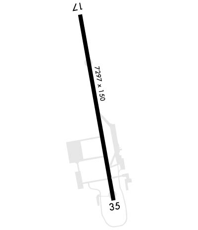
| Lat: N 3440.7 Long: W 08641.1 Elev: 685 Var: +04 Longest Runway: 7300 | ||
| Dept. ATIS: 120.65 Arr. ATIS: 120.65 Tower: 126.95 | ||
| ||||||
| ||||||
|
| Rwy | Rwy | |||||||
| 7300x150 | 7300' | 7300x150 | 7300' | |||||
| Runway ID | Single Wheel | Double Wheel | Double Tandem Wheel | Dual Double Wheel |
| 17/35 | N/A | N/A | N/A | N/A |
| These numbers are Advisory and are not limits. The Airport Manager should have more accurate Weight Limits | ||||
 Airport Diagram might not be current. | |
| Facility Name: | REDSTONE AAF |
| City Name: | REDSTONE ARSNL HUNTSVILLE |
| County: | MADISON |
| State abbrev: | AL |
| State Name: | ALABAMA |
| Ownership: | ARMY OWNED |
| Use: | PRIVATE |
| Owner's Name: | COMMANDER USAASA |
| Address: | 9325 GUNSTON ROAD, BLDG 1466 SUITE N319 |
| FORT BELVOIR, VA 22060 | |
| Owner's Phone: | |
| Manager's Name: | US ARMY |
| Address: | AMSAM-RA-EPW-BA BLDG 4488 |
| HUNSTVILLE, AL 35898 | |
| Phone: | |
| FAA Region: | SOUTHERN |
| FAA Field Office: | JAN |

| Date | Sunrise | Sunset |
|---|---|---|
| 06/07/26 Sunday | 5:33 | 19:58 |
| 06/08/26 Monday | 5:33 | 19:58 |
| 06/09/26 Tuesday | 5:33 | 19:59 |
| 06/10/26 Wednesday | 5:33 | 19:59 |
| 06/11/26 Thursday | 5:33 | 20:00 |
| 06/12/26 Friday | 5:33 | 20:00 |
| 06/13/26 Saturday | 5:33 | 20:01 |
| 06/14/26 Sunday | 5:33 | 20:01 |
| 06/15/26 Monday | 5:33 | 20:01 |
| 06/16/26 Tuesday | 5:33 | 20:02 |
| 06/17/26 Wednesday | 5:33 | 20:02 |
| 06/18/26 Thursday | 5:33 | 20:02 |
| 06/19/26 Friday | 5:34 | 20:03 |
| 06/20/26 Saturday | 5:34 | 20:03 |
| Airport Attendance Schedule | MON-FRI 0700-1800, CLDS HOLS |
| Airport Status | OPERATIONAL (This Status can change at any time - please check NOTAMS) |
| Airport Lighting Schedule | WHEN ATCT CLSD ACTVT MALSR RWY 17; PAPI RWY 17 & 35; HIRL RWY 17/35 - CTAF. |
| Airport Storage Available | NONE |
| Extra Services Available | NONE |
| Wind Indicator | NONE |
| Control Tower | YES |
| CTAF Frequency | 126.950 |
| Unicom Frequency | |
| Rotating Beacon Color | SWG |
| Segmented Circle | NO |
| Landing Fee |
| Airport Inspected | No Inspection Data Available performed by the OWNER |
| Inspection Date | Unknown |
| Type of Fuel Available | Grade 100LL |
| Airframe Repair Service | None |
| Power Plant Repair Service | None |
| Latitude | N3440.7 |
| Longitude | W08641.1 (ESTIMATED) |
| Arpt Elevation | 685ft (ESTIMATED) |
| Magnetic Variation | 04W |
| 6 miles SW | of REDSTONE ARSNL HUNTSVILLE |
| Traffic Pattern Altitude | |
| Sectional Chart | ATLANTA |
| Operations (Reported) | Yearly | Avg. Daily |
|---|---|---|
| General Aviation Transient | 0 | 0 |
| General Aviation Local | 0 | 0 |
| Air Taxi | 0 | 0 |
| Commerical | 0 | 0 |
| Commuter | 0 | 0 |
| Military | 0 | 0 |
| Aircraft based on Field | |
|---|---|
| General Aviation Singles | 0 |
| General Aviation Multi | 0 |
| Jet Aircraft | 0 |
| General Aviation Helicopters | 0 |
| Military Aircraft | 0 |
| Gliders | 0 |
| Ultralights | 0 |
| FSS on field | NO |
| FSS tie-in | ANNISTON |
| FSS Phone | 1-800-WX-BRIEF |
| Who issues Notams | HUA |
| Notam D service at airport | YES |
| ARTCC Name | MEMPHIS |
| Airport Certification | |
| Aircraft Rescue & Firefighting Index | None |
| Airport of Entry | No |
| Custom Landing Rights | No |
| Joint Civil/Military | No |
| Military Landing rights | No |
| FUEL: A ++ (AVBL 1230-0330Z++ MON-FRI EXC HOL; OT O/R). |
| TRAN ALERT: LTD SVC. |
| RSTD: 24 HR PPR ALL ACFT, 48 HR PPR ACFT WITH HAZ CARGO. CTC BASE OPS DSN 746-7916/4299 C256-876-1916/4299. REFUL EXP DELAY. ACFT MUST ADHERE TO PPR ARR BLOCK TIME +/- 30 MIN OF SKED LDG. |
| MISC: LTD PRK. NO PHOTOGRAPHY ALLOWED WO BASE OPS APVL. |
| CAUTION: DEER, TUKEY, COYOTE HAZ. ACFT LARGER THAN C-12 USE EXTREME CAUTION WHILE TAXIING DUE TO MIN WG TIP CLNC. |
| RADAR: SEE TERMINAL FLIP FOR RADAR MINIMA. |
| PAR AND PAPI RWY 17-35 ARE COINCIDENTAL. |
| MISC: F/W LARGER THAN C130 RSTD TO TWY D, E, AND N RAMP AREA. LAWRS. ALL TRAN ACFT OPN OTHER THAN KHUA MUST RCV RNG BRIEFING FROM BASE OPS PRIOR TO OPN. |
| BASE OPS - OPR 1300-0300Z++ MON-FRI EXC HOL. OT O/R. 126.2 OR 239.275. |
| AVOID OVFT SATELLITE COM COMPLEX BLW 2000 FT 1.8 NM SE OF AFLD. |
| FOR CD CTC HUNTSVILLE APCH AT 256-542-2070/2080. |
Airport Communications & Frequencies:
| |||||||||||||||||||||||||
| Runway: 17 | Runway: 35 | ||
| Mag heading: | N/A | Mag heading: | N/A |
| Rwy Slope: | -.42% Down | Rwy Slope: | .42% Up |
| Approach: | Approach: | ||
| Pattern: | Left Traffic | Pattern: | Right Traffic; TFC PAT: RGT TFC RWY 35 R/W 1400 FT, F/W SENG 1700 FT, F/W TURBOPROP/JET 2200 FT, OVERHEAD 2700 FT. |
| Markings: | PRECISION INSTRUMENT | Markings: | PRECISION INSTRUMENT |
| Marking Condition: | GOOD | Marking Condition: | GOOD |
| Arresting Dev: | Arresting Dev: | ||
| Lat & Long: | N3441.3 W08641.2 | Lat. & Long.: | N3440.1 W08641.0 |
| Elev: | 685.4 ft. MSL | Elev: | 654.9 ft. MSL |
| TCH: | 46 ft. AGL | TCH: | 50 ft. AGL |
| Visual Glide Path: | 3.00 degrees | Visual Glide Path: | 3.00 degrees |
| Displaced Threshold: | No | Displaced Threshold: | No |
| Touchdown Zone: | YES | Touchdown Zone: | YES |
| Touchdown Elev.: | 685.4 feet | Touchdown Elev.: | 661.3 feet |
| Visual Glide Slope: | 4-Light PAPI on LEFT side of Runway | Visual Glide Slope: | 4-Light PAPI on LEFT side of Runway |
| RVR Equipment: | RVR Equipment: | ||
| RVV Equipment: | NO | RVV Equipment: | NO |
| Approach Lights: | MALSR - 1,400 foot medium intensity approach lighting system with runway alignment indicator lights | Approach Lights: | |
| REIL: | NO | REIL: | NO |
| Centerline Lights: | NO | Centerline Lights: | NO |
| Touchdown lights: | NO | Touchdown lights: | NO |
| Runway Category: | Runway Category: | ||
| Declared Distances: | Declared Distances: |
Thanks for using FltPlan.com
all rights reserved © 1999-2026 by Flight Plan LLC