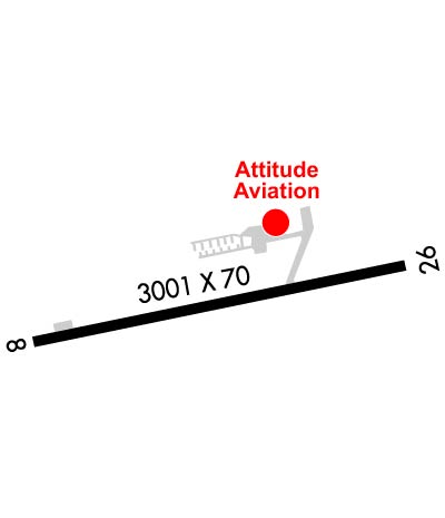
| LAWRENCE COUNTY AIRPARK CHESAPEAKE/HUNTINGTO OH |
| |
| Lat: N 3825.1 Long: W 08229.7 Elev: 567 Var: +05 Longest Runway: 2998 | ||
| CTAF: 122.7 | ||
| |||||||||||||||||||||||
| |||||||||||||||||||||||
| Rwy | Rwy | |||||||
| 2998x70 | 2826' | 2998x70 | 2998' | |||||
| Runway ID | Single Wheel | Double Wheel | Double Tandem Wheel | Dual Double Wheel |
| 08/26 | N/A | N/A | N/A | N/A |
| These numbers are Advisory and are not limits. The Airport Manager should have more accurate Weight Limits | ||||
| FltPlan does not have IFR approach charts available for KHTW. |
 Airport Diagram might not be current. | |
| Facility Name: | LAWRENCE COUNTY AIRPARK |
| City Name: | CHESAPEAKE/HUNTINGTON WVA |
| County: | LAWRENCE |
| State abbrev: | OH |
| State Name: | OHIO |
| Ownership: | PUBLICLY OWNED |
| Use: | OPEN TO THE PUBLIC |
| Owner's Name: | LAWRENCE CO BOARD OF COMMISSIONERS |
| Address: | COURTHOUSE, 111 S 4TH ST |
| IRONTON, OH 45638-1522 | |
| Owner's Phone: | 740-533-4300 |
| Manager's Name: | NELSON WHITT & MARIE PHILLIPS |
| Address: | 9564 COUNTY ROAD 1 |
| SOUTH POINT, OH 45680 | |
| Phone: | 304-634-0291; OR 304-633-1023. |
| FAA Region: | GREAT LAKES |
| FAA Field Office: | DET |
| Date | Sunrise | Sunset |
|---|---|---|
| 09/24/21 Friday | 7:19 | 19:24 |
| 09/25/21 Saturday | 7:20 | 19:23 |
| 09/26/21 Sunday | 7:21 | 19:21 |
| 09/27/21 Monday | 7:22 | 19:19 |
| 09/28/21 Tuesday | 7:23 | 19:18 |
| 09/29/21 Wednesday | 7:24 | 19:16 |
| 09/30/21 Thursday | 7:25 | 19:15 |
| 10/01/21 Friday | 7:26 | 19:13 |
| 10/02/21 Saturday | 7:26 | 19:12 |
| 10/03/21 Sunday | 7:27 | 19:10 |
| 10/04/21 Monday | 7:28 | 19:09 |
| 10/05/21 Tuesday | 7:29 | 19:07 |
| 10/06/21 Wednesday | 7:30 | 19:06 |
| 10/07/21 Thursday | 7:31 | 19:04 |
| Airport Attendance Schedule | OCT-APR 7 Days A Week 0900-DUSK, MAY-SEP 7 Days A Week 0800-DUSK |
| Airport Status | OPERATIONAL (This Status can change at any time - please check NOTAMS) |
| Airport Lighting Schedule | ACTVT MIRL RWY 08/26 - CTAF. |
| Airport Storage Available | Tie Downs, Hanger |
| Extra Services Available | Flight Instruction, Aircraft Rental |
| Wind Indicator | YES - (unlit) |
| Control Tower | NO |
| CTAF Frequency | 122.700 |
| Unicom Frequency | 122.700 |
| Rotating Beacon Color | CLEAR-GREEN (Light Land Airport) |
| Segmented Circle | NO |
| Landing Fee | NO |
| Airport Inspected | STATE - performed by STATE AERONAUTICAL PERSONNEL |
| Inspection Date | 10/01/2020 |
| Type of Fuel Available | Grade 100LL; -10AVBL H24 SELF SER VIA CREDIT CARD. |
| Airframe Repair Service | MAJOR |
| Power Plant Repair Service | MAJOR |
| Latitude | N3825.1 |
| Longitude | W08229.7 (ESTIMATED) |
| Arpt Elevation | 567ft (SURVEYED) |
| Magnetic Variation | 05W |
| 2 miles W | of CHESAPEAKE/HUNTINGTON WVA |
| Traffic Pattern Altitude | 1040 |
| Sectional Chart | CINCINNATI |
| Operations (Reported) | Yearly | Avg. Daily |
|---|---|---|
| General Aviation Transient | 2750 | 8 |
| General Aviation Local | 38500 | 105 |
| Air Taxi | 495 | 1 |
| Commerical | 0 | 0 |
| Commuter | 0 | 0 |
| Military | 165 | 0 |
| Aircraft based on Field | |
|---|---|
| General Aviation Singles | 27 |
| General Aviation Multi | 2 |
| Jet Aircraft | 0 |
| General Aviation Helicopters | 0 |
| Military Aircraft | 0 |
| Gliders | 0 |
| Ultralights | 0 |
| FSS on field | NO |
| FSS tie-in | DAYTON |
| FSS Phone | 1-800-WX-BRIEF |
| Who issues Notams | DAY |
| Notam D service at airport | YES |
| ARTCC Name | INDIANAPOLIS |
| Airport Certification | |
| Aircraft Rescue & Firefighting Index | None |
| Airport of Entry | No |
| Custom Landing Rights | No |
| Joint Civil/Military | No |
| Military Landing rights | No |
| NATIONAL PLAN OF INTEGRATED AIRPORT SYSTEMS (NPIAS) |
| FOR CD CTC INDIANAPOLIS ARTCC AT 317-247-2411. |
| Runway: 08 | Runway: 26 | ||
| Mag heading: | 80° | Mag heading: | 260° |
| Rwy Slope: | .32% Up | Rwy Slope: | -.32% Down |
| Approach: | Approach: | ||
| Pattern: | Left Traffic | Pattern: | Left Traffic |
| Markings: | BASIC | Markings: | BASIC |
| Marking Condition: | GOOD | Marking Condition: | GOOD |
| Arresting Dev: | Arresting Dev: | ||
| Lat & Long: | N3825.1 W08230.0 | Lat. & Long.: | N3825.2 W08229.4 |
| Elev: | 554.9 ft. MSL | Elev: | 564.6 ft. MSL |
| TCH: | TCH: | ||
| Visual Glide Path: | Visual Glide Path: | ||
| Displaced Threshold: | 172 feet | Displaced Threshold: | No |
| Touchdown Zone: | YES | Touchdown Zone: | YES |
| Touchdown Elev.: | 567.1 feet | Touchdown Elev.: | 567.1 feet |
| Visual Glide Slope: | Visual Glide Slope: | ||
| RVR Equipment: | RVR Equipment: | ||
| RVV Equipment: | NO | RVV Equipment: | NO |
| Approach Lights: | Approach Lights: | ||
| REIL: | NO | REIL: | NO |
| Centerline Lights: | NO | Centerline Lights: | NO |
| Touchdown lights: | NO | Touchdown lights: | NO |
| Runway Category: | Runway with a Visual Approach | Runway Category: | Runway with a Visual Approach |
| Declared Distances: | Declared Distances: | ||
| Obstructions: | BRUSH | Obstructions: | |
| Marked: | NOT Marked/Lighted | Marked: | |
| Clearance slope: | APCH SLP TO DTHR 12:1 DUE TO +55 FT TREE, 882 FT DIST, 50 FT R. | Clearance slope: | 20:1 |
| Obstruction height: | 2 feet AGL | Obstruction height: | |
| Dist. from runway: | 201 feet | Dist. from runway: | |
| Centerline offset: | 70 left of centerline | Centerline offset: | |
| Comments: | +10 FT ROAD, 0 FT DIST, 45 FT R; +4-15 FT BRUSH, 90-200 FT DIST, 70-125 FT L; +2-13 FT BRUSH, 0-200 FT DIST, 80-125 FT R. | Comments: | +1-2 FT BRUSH, 63 FT DIST EXTDG TO DROP-OFF, 125 FT L/R. |
Thanks for using FltPlan.com
all rights reserved © 1999-2021 by Flight Plan LLC